
Characteristics of the Region
Administratively, the region is part of the Askizsky District of the Krasnoyarsk Krai and borders on the Kemerovo Oblast to the east.
The mountain-taiga steel railway line Novokuznetsk—Abakan connects the remote, previously hard-to-reach areas of Khakassia and Kuznetsk Alatau.
Departing from Novokuznetsk station at 17:25, the train arrives at Luzba station at 23:30 local time.
The region's climate is sharply continental and harsh. Abundant precipitation contributes to the lush development of vegetation in the summer.
During the winter months, a thick snow cover accumulates; in river valleys, it reaches a thickness of 2–3 meters, hiding buildings under it. In settlements:
- Footpaths are laid at the level of eaves;
- Train compositions run along tracks in deep snow trenches.
The administrative boundary of the regions almost coincides with the climatic boundary: the eastern slopes of Kuznetsk Alatau, located in Khakassia, differ significantly from the western slopes in terms of precipitation, and in winter, the snow cover is much less beyond the Tiger-Tyshsky and Surgassky ridges. This area has significantly more sunny days than the valleys of the Kozyr, Bel-Su, Amzas rivers, etc.
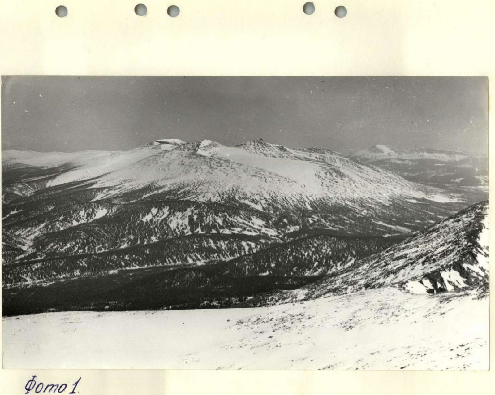
Relief. Kuznetsk Alatau, bordering the Kuznetsk depression to the east, is an orographically complex massif where absolute heights reach 2000–2100 m above sea level. The region is generally characterized by mid-mountain relief, transitioning into small-hilly, hilly-ridge relief to the east (Photo 1).
Rocky screes are widespread in the ridge, especially above the limits of tree vegetation, which rises to 1100 m in the north and to 1400–1500 m in the south. Kuznetsk Alatau:
- merges with the elevations of Gornaya Shoria to the south;
- rises and diverges into separate ridges fan-shaped to the northwest, north, and northeast, gradually losing height and turning into gentle ridges.
Near the Siberian railway line, Kuznetsk Alatau merges with the West Siberian Plain.
The central part of Kuznetsk Alatau, which is the area of the planned ascents, is a sharply expressed, high-mountain, highly dissected country.
There are no clearly defined mountain ranges within Kuznetsk Alatau. Among the randomly located mountain peaks, it is only possible to outline the main line along which the highest peaks are located and which can be conditionally called a ridge.
The alpine areas are characterized by high-mountain landscape forms along with steep rocky cliffs; huge rocky screes are almost ubiquitous. Glacial cirques and lakes are frequently observed.
Such alpine zones are remnants of the most ancient relief of Kuznetsk Alatau. They existed before the glaciation, as traces of the latter are preserved on individual alpine peaks. The alpine relief zone is likely of Mesozoic or Tertiary age. The crust of the most ancient weathering is preserved on the surface of the peneplain.
The most acute alpine relief forms are expressed on the Tiger-Tysh ridge, which translates to "Heavenly Teeth" in Russian. The Tiger-Tysh ridge, covering an area of 100 sq.km, makes a strong impression with its picturesque rocky cliffs, cliffs (Photo 2), pointed peaks covered with individual snow patches, and an abundance of mountain lakes.
The central part of the ridge is stretched in the latitudinal direction. The northern end, curved like a horseshoe, forms huge cirques of the sources of rivers:
- Bel-Su;
- Karatash;
- Turalyg.
The western part of the ridge circularly borders the sources of the Tuyuk-Su and Bel-Su rivers.
In this cirque, a glacial landscape with numerous stepped cirques is sharply expressed. The ledges of the lower part of the cliffs are covered with firn fields descending to the glacial "Graduates'" lake. The eastern part of the lake is dammed by a moraine rampart, which steeply descends to the valley of the Tuyuk-Su river, flowing into the Bel-Su river.
Similar glacial relief forms are traced in the southern end of the ridge, circularly bordering the sources of the Kazyr river. Stepped cirques and lakes are also observed in this part.
Vegetation: the vegetation cover of the mountain-taiga zone is not uniform and is characterized by significant diversity. In the dark coniferous taiga on deeply podzolic soils, fir and aspen dominate in the tree layer. In the upper reaches of mountain rivers on the same soils, cedar-fir taiga is widespread, but pure cedar areas are rare. In the eastern regions, on the border with Khakassia, larch appears.
Herbaceous vegetation in mountain forests is distinguished by its extraordinarily lush development. Some grasses reach 2 m or more in height.
For example:
- bright blue delphinium;
- umbellifers;
- composites;
- ranunculaceae.
These giant dark coniferous grasses form impenetrable thickets, a kind of dark coniferous prairies.
In the fir-spruce-cedar taiga, herbaceous vegetation is poorer. Among the flowering plants on the mossy soil cover, one usually finds:
- wintergreen;
- lily of the valley;
- bogulnik, etc.
Among shrubs, here as well as throughout the Kemerovo Oblast, one finds:
- bird cherry;
- rowan;
- viburnum;
- raspberry;
- red and black currant;
- elderberry;
- honeysuckle;
- acacia.
The slopes of alpine meadows are covered with orange marigolds, beautiful lush peonies, violets, and forget-me-nots in the spring. A wonderful world.
Wildlife. The "Heavenly Teeth" region is rich in game hunting. Maral deer, roe deer, musk deer, reindeer, and elk inhabit the areas of Kuznetsk Alatau. Many of the game mammals were exterminated by the beginning of our century, but thanks to the conservation measures of the Soviet government, their numbers have significantly increased. The stocks of maral deer and roe deer have especially replenished.
Both these species make migrations in spring and autumn:
- in autumn, in September, they move in large herds to Khakassia, overcoming mountains and turbulent rivers on their way;
- in spring, in May, they return to their old places.
These migrations are explained by the deep snow cover in the mountains, making it difficult for animals to move and find food in winter. For this reason, it is almost impossible to meet a wolf in the taiga. This predator sticks to open areas and is not found in the mountains.
The mountain taiga is rich in predators such as:
- bear;
- lynx;
- wolverine. The sable is still preserved in these places.
On secluded taiga rivers, otters live; grayling and perch are found in the rivers.
In the taiga, one can also meet foxes, many squirrels, kolinsky, ermine, hares, many weasels, and chipmunks. In the coniferous taiga, among birds, one finds black grouse and many hazel grouse. On the alpine areas, white partridges are often encountered.
Approach. It is recommended to make a winter ski approach to "Graduates'" lake at the end of March — beginning of April, when the ski trail goes along a good crust, but a sharp warming has not yet begun, which entails:
- rapid snowmelt;
- the opening of streams and rivers;
- cutting off the path to the exit to the railway.
The path lies along the Amzas river to its upper reaches through the Bel-Su pass to the Tuyuk-Su river and further up to "Graduates'" lake.
Map of the ascent area.
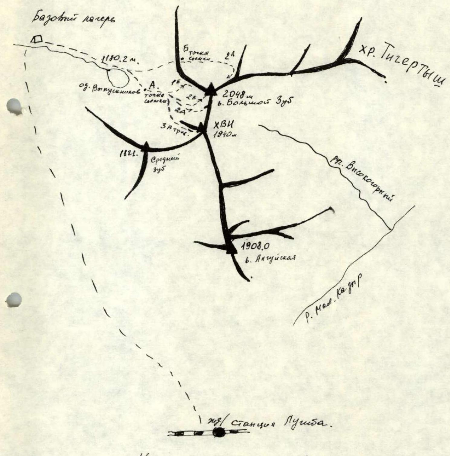
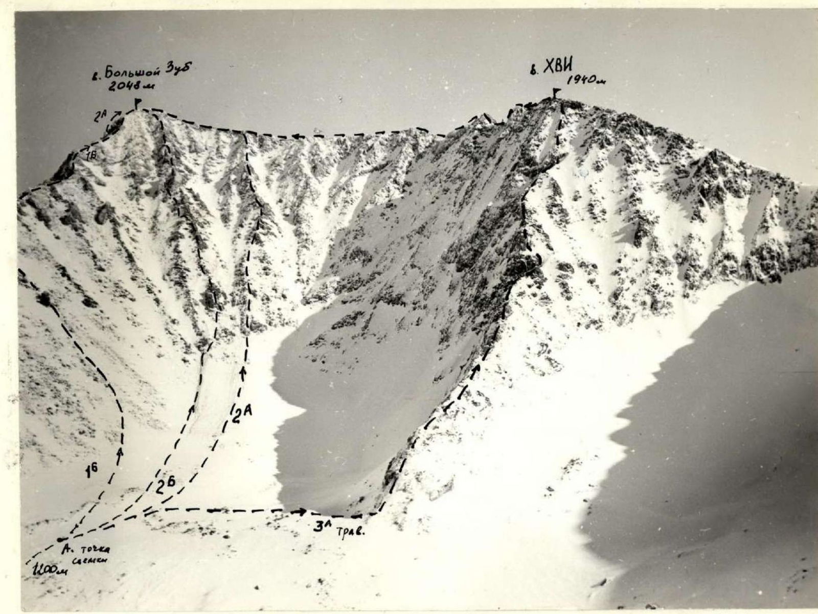
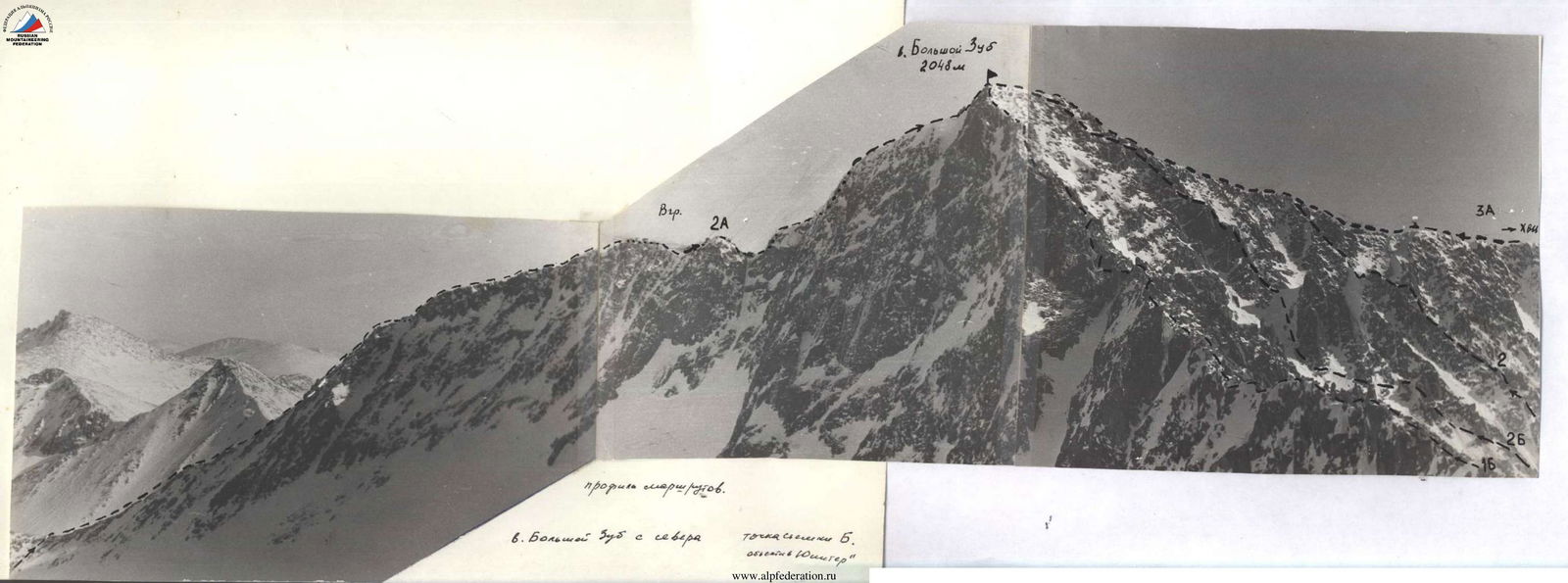
Bolshoy Zub via the Southeast Ridge. (Combined route, 1B category of difficulty)
From "Graduates'" lake, approach on skis along the northern slope of the southeast ridge of Bolshoy Zub to the snow plateau. Travel time — 1.5 hours. Leave skis on the plateau and move along the steep slope under the gendarmes with a simultaneous traverse towards the summit.
Passage scheme:
- The first sharp gendarme is bypassed on the left;
- From it, straight up to the ridge.
Up to the gendarmes, insurance is through an ice axe, further — alternate insurance through ledges until exiting onto the ridge. Attention! There are many snow cornices on the ridge. Movement along easy rocks with variable insurance. The route is ridge-like. Encountering gendarmes are passed "head-on". Sections of accrued ice are encountered.
The key section of the route is the passage of the last gendarme:
- Climbing of medium difficulty;
- In case of strong wind, a bypass to the right is possible, insurance is alternate.
Exit to the summit along easy snowy rocks, insurance through ledges, movement is simultaneous. Ascent from the plateau — 4 hours 30 minutes.
Descent from the summit along the ascent path takes 3 hours. Recommended equipment for a group of 6 people:
- Crampons — 6 pairs
- Main rope — 3 × 30 m
- Rock hammers — 2 pcs.
- Rock pitons — 6 pcs.
- Ice axes — 6 pcs.
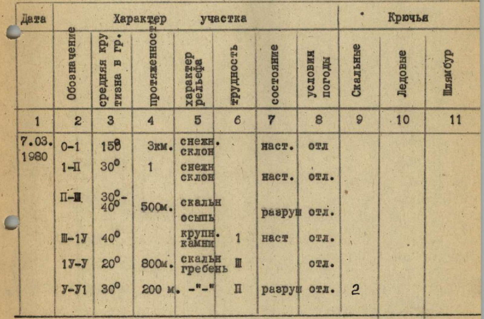
TABLE of main characteristics of the ascent route area
General view of the summit. Photo from a helicopter from the west.
General data (Information about the summit) from the website.
Photo 1.
 Profile of the routes. Bolshoy Zub from the north.
| Date | Designation | Average steepness, ° | Length | Character of relief | Difficulty | Condition | Weather conditions | Rock | Ice | Bolts |
|---|---|---|---|---|---|---|---|---|---|---|
| 7.03.1980 | R0–R1 | 15° | 3 km | snow slope | crust | excellent | ||||
| R1–R2 | 30° | 1 | snow slope | crust | excellent | |||||
| R2–R3 | 30°–40° | 500 m | rocky scree | destroyed | excellent | |||||
| R3–R4 | 40° | large stones | 1 | crust | excellent | |||||
| R4–R5 | 20° | 800 m | rocky ridge | excellent | ||||||
| R5–R6 | 30° | 200 m | 2 | destroyed | excellent | 2 |
Photo 2. H.Vi-B.Zub ridge from the western side.
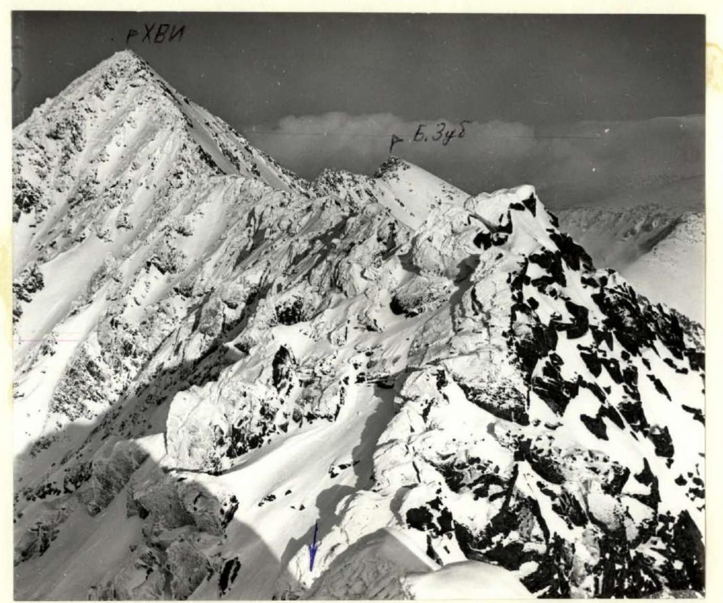
Photo 3. Photo from Sredniy Zub. The arrow indicates a snow plug.
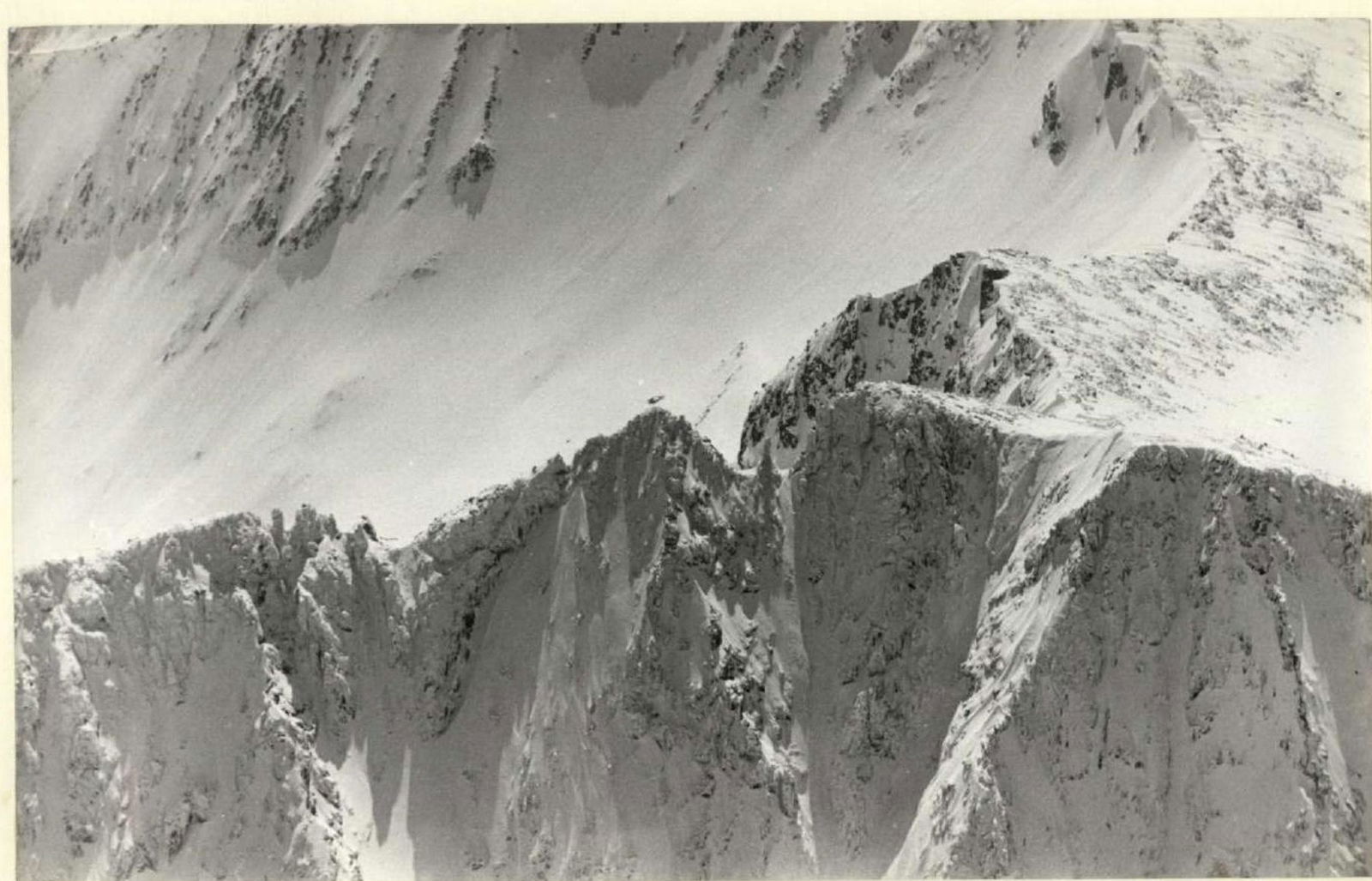
Photo 4. "Mushko" area of Maly Zub.
Comments
Sign in to leave a comment