Ascent Passport
- Altai, Severo-Chuyskie Belki ridge, Akturu valley, section 1.
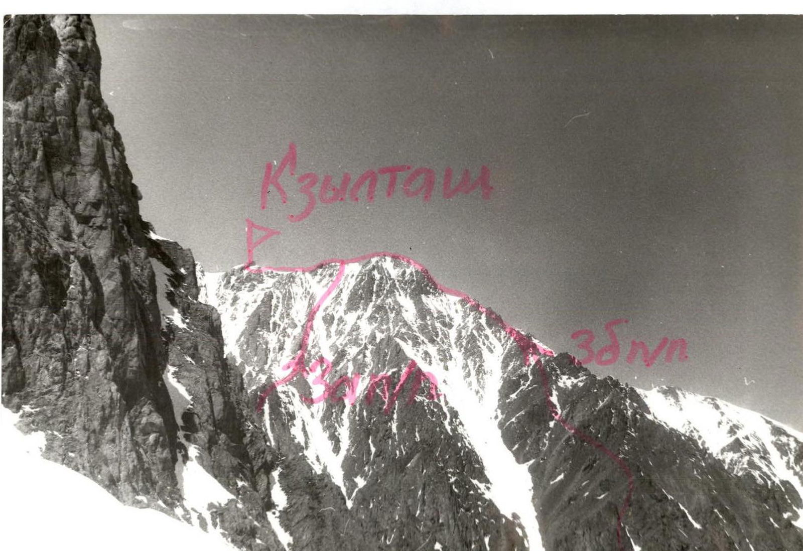
- Kzyl-Tash peak, 3486 m, via the right ridge of the South slope.
- Proposed category 3B, first ascent.
- Route type — rock climbing.
- Height difference — 1200 m, length — 3000 m, average slope — 30°, steepest section — 55°.
- Pitons used: rock and chocks — 15.
- Team's total climbing hours — 12 hours.
- Leader — Afanasiev A.E., Master of Sports. Team members — Salin A.V., 1st sports category, Kuznetsova T.Yu., 2nd sports category.
- Coach — Afanasiev A.E.
- Departure and return — July 21, 1998.
Kzyl-Tash
3486
Route description for ascending Kzyl-Tash peak, 3486 m via the right buttress of the South slope, approximately category 3B.
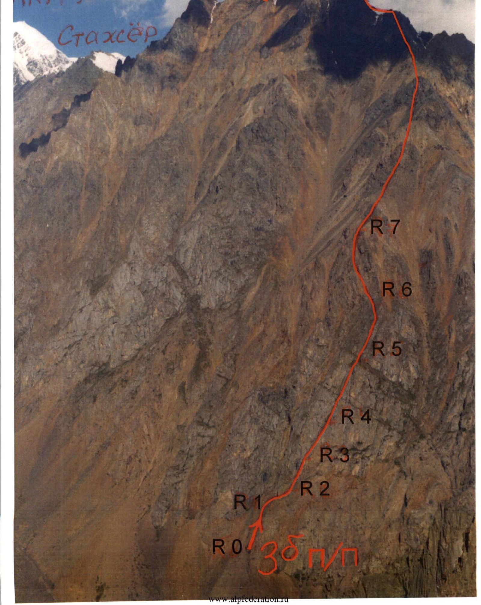
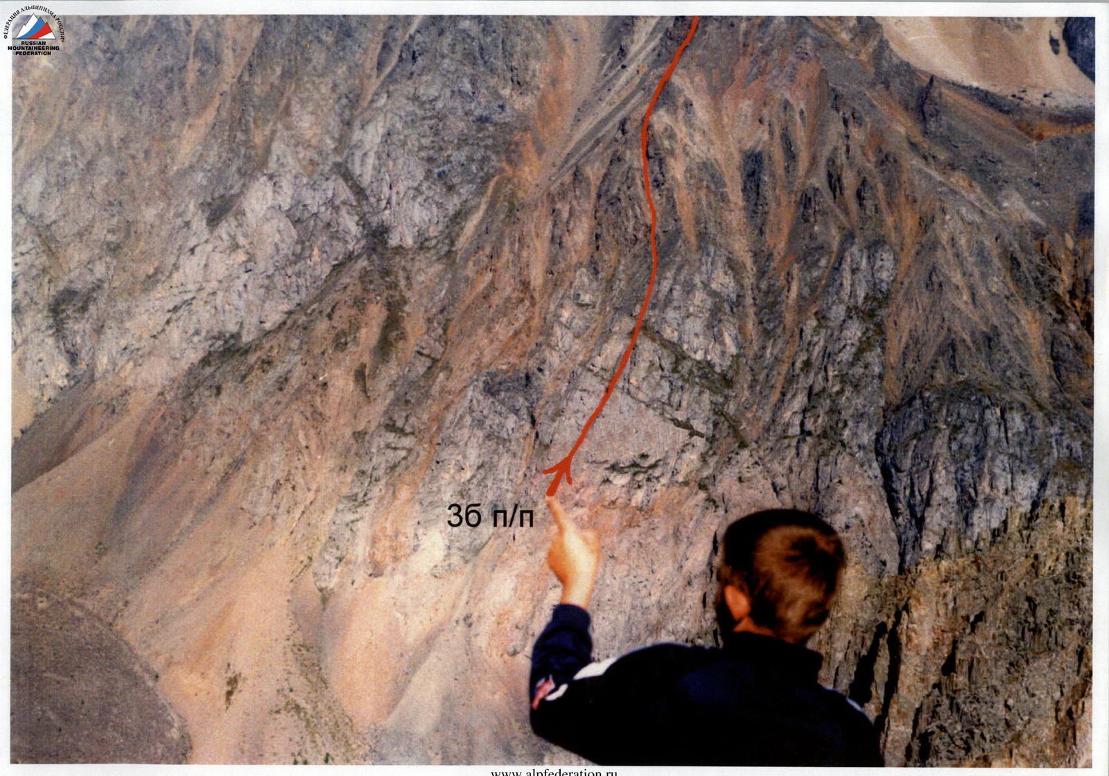
Approach to the route — from Kedrovy Island at the confluence of Bolshaya and Malaya Akturu rivers. Up the slope slightly left towards the black rocks at the top of the black talus cone — half an hour's walk. Then up to the right onto the ridge of red rocks about 150 m. There's a cairn on the ridge. From the ridge, an internal corner-chimney with a large rock plug is visible. The route goes through it.
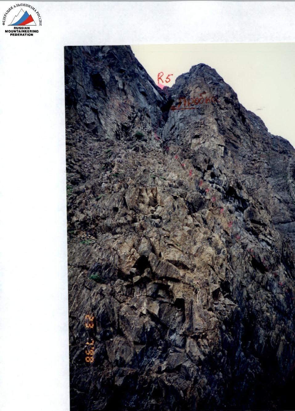
Section 0–1 70 m. 45° II+. From the cairn up to the right and left across slabs, belay with pitons, exit onto the buttress. Section 1–2 50 m. 50° III+. Series of ledges on the wall to the right of the ridge, 3 pitons. Section 2–3 30 m. 50° II−. Diagonal ledge to the right into a chimney with a large plug. From section 2, there's a traverse to the left edge of the buttress and then an equivalent ascent to the top of the buttress. Section 3–4 50 m. 55° II+. Start of the chimney. Approach to the plug. Section 4–5 70 m. 60° IV−. From under the plug to the right and then along the right rock edge of the chimney. Belay with pitons, handrails. Section 5–6 100 m. 55° III+. In the middle of the internal corner, there's a slippery grassy slope with rock outcrops. Alternating movement. Belay via rock pitons. Exit onto the right ridge. Section 6–7 90 m. 50° III−. Broken rocks. Exit onto the main ridge. Section 7–8 750 m. 30° II−. Along the ridge of the right buttress, overcoming gendarmes head-on or from the left, approach under the black gendarme. Section 8–9 80 m. 50° III+. The gendarme is climbed head-on, 3 pitons. Traverse left onto the East snowy ridge of the category 3B route. Section 9–10 90 m. 45° III−. Ice slope. Climbed using crampons and ice axes. Belay via ice screws. Section 10–11 40 m. 60° III+. Crevasse. The key section of the category 3B route. Exit onto a large gendarme. Section 11–12 450 m. II−. Pre-summit ridge. Two gendarmes are bypassed on the left, one on the right. Approach under the summit tower. Section 12–13 25 m. 80° IV−. Crevasse-chimney. Exit onto the summit. Descent via the category 1B route through Konteyner pass. Kzyl-Tash peak 3486 m via the right buttress of the South slope, approximately category 3B.
Kzyl-Tash 3486 m, via the right buttress of the South slope, approximately category 3B.
| Rock and chock pitons | Ice screws | Section | Difficulty | Length | Steepness |
|---|---|---|---|---|---|
| 3 | R12 | IV− | 25 m | 80° | |
| R11 | II− | 450 m | |||
| 4 | R10 | III+ | 40 m | 60° | |
| 3 | R9 | III− | 90 m | 45° | |
| 3 | R8 | III+ | 80 m | 50° | |
| R7 | II− | 750 m | 30° | ||
| 1 | R6 | III− | 90 m | 50° | |
| 1 | R5 | III+ | 100 m | 50° | |
| 3 | R4 | IV− | 70 m | 60° | |
| 2 | R3 | II+ | 50 m | 55° | |
| 1 | R2 | II− | 50 m | 50° | |
| 3 | R1 | III+ | 50 m | 50° | |
| R0 | II+ | 70 m | 45° | ||
| Total: 21 | 3 |
Kzyl-Tash

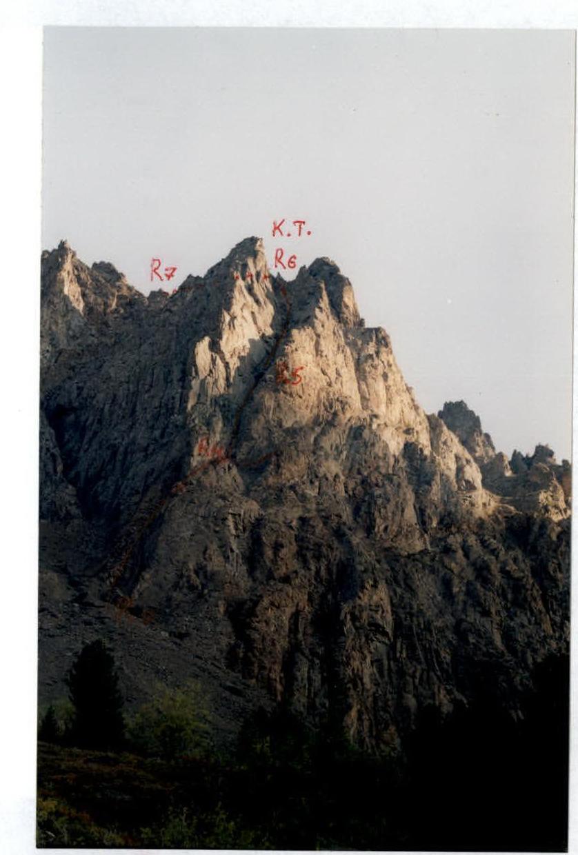
The wall section of the category 3B route on Kzyl-Tash peak via the right buttress of the South slope.