Karatash 4A via North wall V. Kozhin 1956
Between 1990 and 1999, the author climbed all existing routes marked on the map on Karatash peak. During the first ascent of the SE couloir of the NE ridge on October 18, 1990, by a group consisting of:
- Afanasyev A.,
- Arshavsky N.,
- Malashchenko A.,
- Mishkov A.,
- Shilkin E.
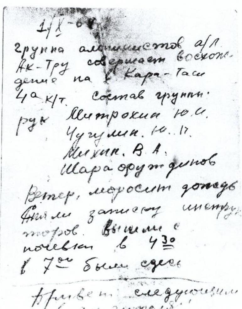
a note was found dated October 1, 1969, from a group consisting of Mitrokhin Yu.I., Chugulin Yu., Mikhin V.A., Sharafutdinov. Later, on July 25, 1998, an ascent was made along the NE buttress, where signs of previous ascents were found in some places:
- a platform on a talus shelf,
- a rock hook,
- remnants of a rope.
Also, from the archives of the Akturu alpine camp, a description of the 4A category route (given below) was preserved, indicating that the route went along the E wall of the NE ridge, to the left of the NE buttress of the NE ridge. When the N wall of Karatash was not yet climbed, the name of the route was not critical for the first ascenders in 1956, or was given incorrectly. Now we believe that the correct name would be:
Karatash 4A via East wall V. Kozhin 1956
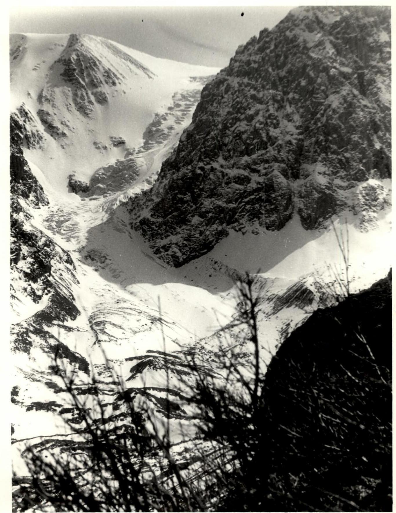
 The approach from the Aktru alpine camp to the northeast ridge is straightforward and initially follows the Aktru river valley, old terminal moraines, and the Maly Akturu glacier. The ascent to the glacier and its lower section is simple. Below the northeast ridge, the glacier turns to the right, its steepness increases, and further movement is only possible with crampons. By bypassing the lower steep ice slope to the left, one needs to reach the start of the second ice slope, keeping direction towards the start of a broad rocky terrace.
After ascending the ice slope with a 30° gradient for two to three rope lengths, descend to a bergschrund opposite a small talus couloir. The width of the bergschrund and the steepness of the ice slopes vary annually and can present a considerable obstacle. The bergschrund is crossed via snow bridges or ice plugs.
The talus couloir leads to a terrace covered with fine debris and green moss. Move up and to the right along the terrace to a broad rocky chute with a 50–60° gradient and 2.5–3 rope lengths long. The left side of the chute is a rocky wall, and the right side is a sharp buttress ridge. The rocks in the chute are of medium difficulty, wet, and thus heavily weathered, though they appear monolithic. Move up the chute with alternating protection via ledges. The chute ends in a sheer wall, which is overcome on the right side via a poorly defined chimney (15–30 m). The rocks are difficult and require piton protection. From the chimney, exit onto the sharp crest of the buttress, where, opposite a red-brown gendarme on the main ridge, the first control cairn is built. The ascent from the glacier to the first control cairn takes 1–1.5 hours.
The buttress is separated from the main ridge by a narrow couloir turning into a vast crevice, which widens further up, approaching the main ridge. The ascent from R1 goes up the buttress on its right side. The buttress crest leads to the base of a rocky wall with a 75–80° gradient, one rope length long, which is climbed on the left side, then across ledges to the right to a small internal corner, from which one exits onto the crest. The ascent on this section involves alternating protection via ledges. The rocks are heavily weathered, with many loose stones. The rocks on this section are of medium difficulty.
After crossing the crest, also heavily weathered, traverse the couloir and exit onto the main ridge below the "Stenka" gendarme. The ascent to the ridge is via rocks of medium difficulty with a 50–55° gradient over 15–20 m. On the ridge below the gendarme, the 2nd control cairn is built. The ascent from R1 to R2 takes 1 hour 20 minutes to 1 hour 40 minutes.
From R2, bypassing the main ridge's steep section to the left via ledges and small vertical walls 5–7 m long on rocks of medium difficulty, exit onto a small talus terrace. Move up and to the right along the terrace to an internal corner bounded by sheer walls on both sides. A short 3–5 m sheer wall with a narrow ledge leads to the internal corner. Move along the ledge to the right to start ascending the internal corner. The rocks are very difficult, nearly devoid of holds. Move with piton protection. The middle section of the corner, completely lacking holds, requires an artificial hold (piton). The upper part of the internal corner has a slight negative incline. Exiting the corner is via a sloping ledge covered with moss and embedded loose stones, significantly hindering passage. The first climber should proceed without a backpack. The internal corner has an 86–90° gradient and is one rope length long.
After passing the corner, descend into a depression to the left of the "Balda" gendarme and then bypass it via a ledge on the left. On the main ridge, after bypassing the gendarme, the 3rd control cairn is built. On this section, a broad, then narrowing couloir descends from the main ridge to the east. North of the "Balda" gendarme, a distinctive rocky spire ("Ukazuyushchiy perst" or "Pointing finger") stands out. From R3, move along rocks of medium difficulty slightly left of the main ridge. Then, after ascending a vertical wall 8 m high, exit to the right onto a section of inclined slabs via a ledge. The slabs are 2 rope lengths long with a 30° gradient. The upper part of the slabs is snowy, wet, and rough. After ascending the lower part of the slabs (30–35 m), traverse to the right through a small ice couloir (45–50°) with piton protection and then exit onto a red-brown, heavily weathered rocky crest. Along a weathered ledge, approach the base of a gendarme, which is bypassed on the right. The bypass is along the boundary between rocks and ice with piton protection and step cutting, as the ice has a 55–60° gradient. Exit from under the gendarme via an ice ledge overhung by rocks (crawl) into a crevice leading to the main rocky ridge. Further along rocks of medium difficulty, with frequent vertical walls (3–5 m), and narrow ledges, approach the next gendarme. The gendarme is bypassed on the left via ledges. On the shoulder of this gendarme is the 4th control cairn. The ascent from R2 to R4 takes 4.5–5 hours.
After the cairn, a short descent along easy rocks to the right onto the ridge. The ridge is talus-covered and snow-capped. Below the gendarme, there's a convenient platform for an overnight bivouac. The journey from camp to the bivouac takes 9–10 hours.
The next day, continue along the snowy ridge and onto the rocks of a gendarme. Bypass the gendarme on the left via ledges on rocks of medium difficulty, exiting to an ice couloir between gendarmes. Cross the couloir in its upper part. Further along rocks of medium difficulty, via small walls and ledges, ascend the gendarme. Then, also along rocks of medium difficulty, exit onto the next gendarme. The entire path along these three gendarmes is not particularly technically challenging, but the climbing is monotonous and thus tiring. Descending from the last gendarme leads to a snowy ridge, which gradually becomes less steep and ends at the summit. The ridge has a 35–40° gradient and is bounded on the left by cornices and on the right by steep snow and ice slopes. Move along the snowy ridge initially in three pitches with protection via rocky outcrops protruding from the snow.
The journey from the bivouac to the summit takes 4.5–5 hours. Descend from the summit to the south along fine and medium talus onto a snowy plateau, then move across the snowy plateau towards the Kupol peak. Traverse the slopes of Kupol peak and descend along fine talus to the "green hotel", from where a broad couloir with coarse talus leads into the Aktru valley, and return to camp. The descent from the summit takes 3.5 hours. The descent route from Karatash peak is described in detail.
Itinerary.
Day 1:
- From camp, ascend via Maly Akturu glacier to the start of the rocky ascent – 2–2.5 hours.
- Ascent to R1 – 1.5 hours.
- Ascent from R1 to R2 below "Stenka" gendarme – 1.5 hours.
- Ascent from R2 to R4, overnight bivouac – 5 hours.
Total ascent time on Day 1 – 10.5 hours.
Day 2:
- Crossing the last three gendarmes to reach the summit – 4.5–5 hours.
- Descent from the summit – 3.5–4 hours.
Total travel time on Day 2 – 8–9 hours.
East wall of Karatash. Maly Akturu Glacier.