Passport
- Class of technical ascents.
- Altai, Severo-Chuysky ridge, Karagem gorge.
- Karagem peak (3) via the northern wall.
- 5B category of difficulty.
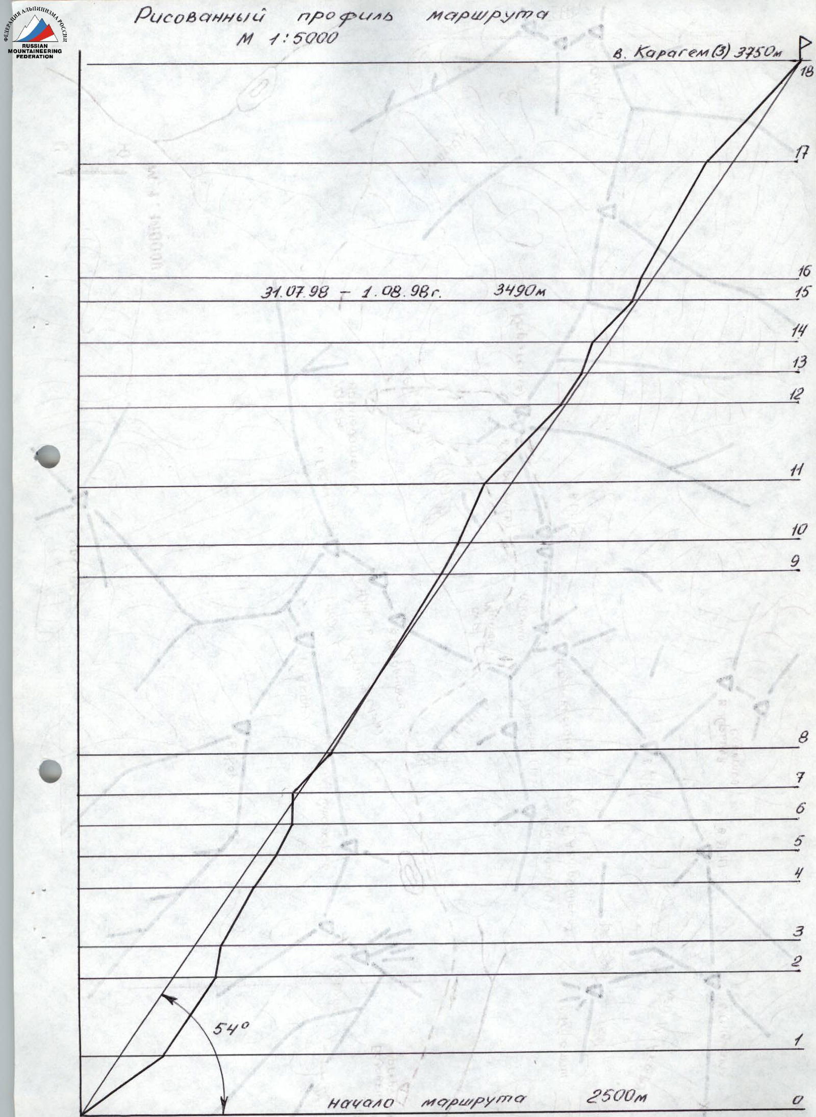
- Elevation gain — 1250 m, length — 1450 m, average steepness — 54°.
- Pitons hammered: rock — , ice — 8, chocks — 136.
- Climbing hours: 29 hours, 2 days.
- Overnight stay on a platform made on the ridge.
- Leader: Sergeev Viktor Platonovich — Master of Sports, 658218, Altai Krai, Rubtsovsk, 64-14 Svetlova St. Participants: Vinnikov Evgeny Anatolyevich — 1st sports category. Tumyalis Vladimir Vitalius — Master of Sports.
- Coach: Sadykov Vladislav Zanievich — 1st category coach.
- Departure on the route: July 31, 1998. Summit: August 1, 1998. Return: August 1, 1998.
- Organization: Sports Committee of Rubtsovsk.
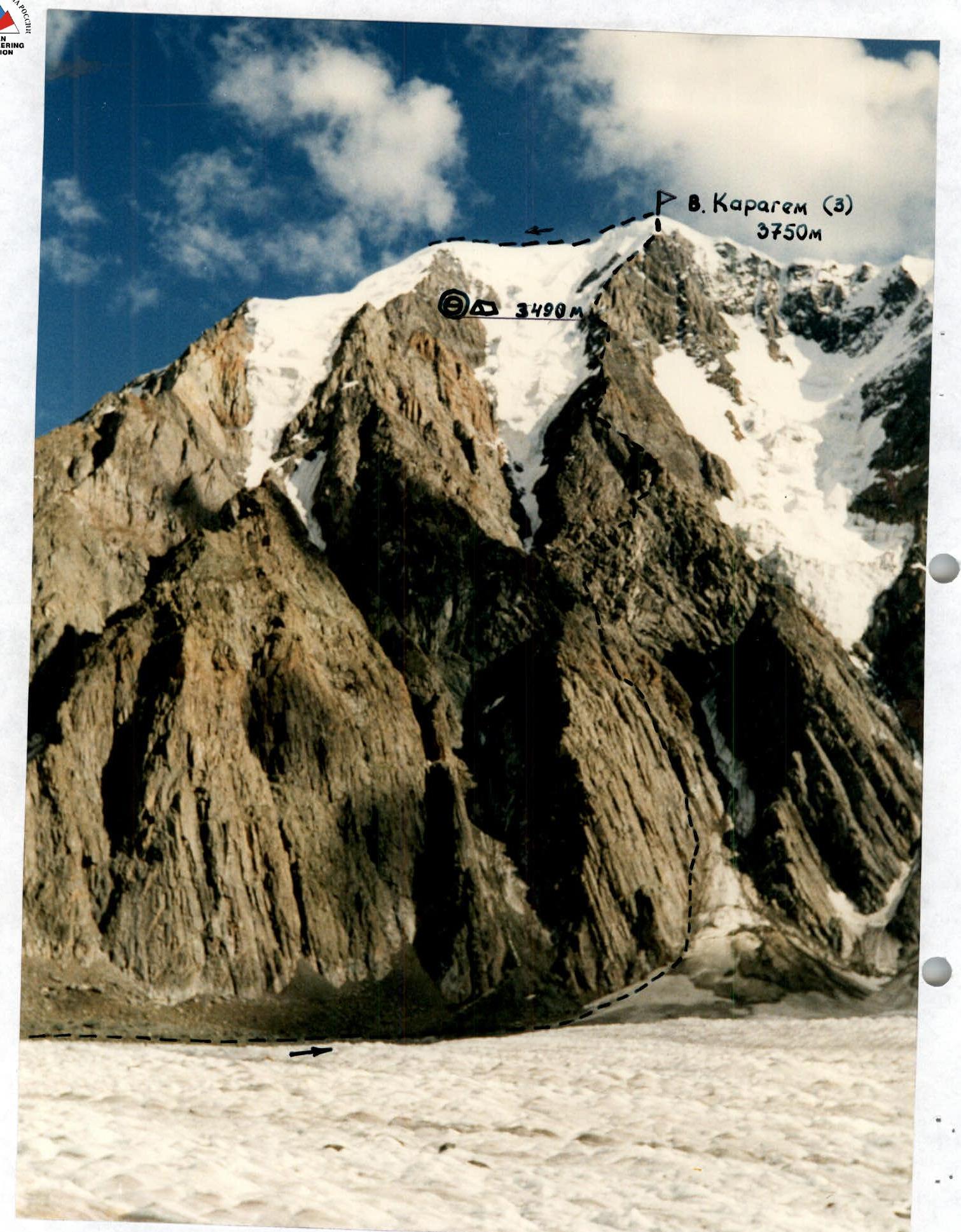
Photo # 1. General photo of the summit.
- Θ
- △
- Overnight stay
Taken with a "PENTAX-PC-100" camera. Shooting point # 1.
Brief overview of the ascent area
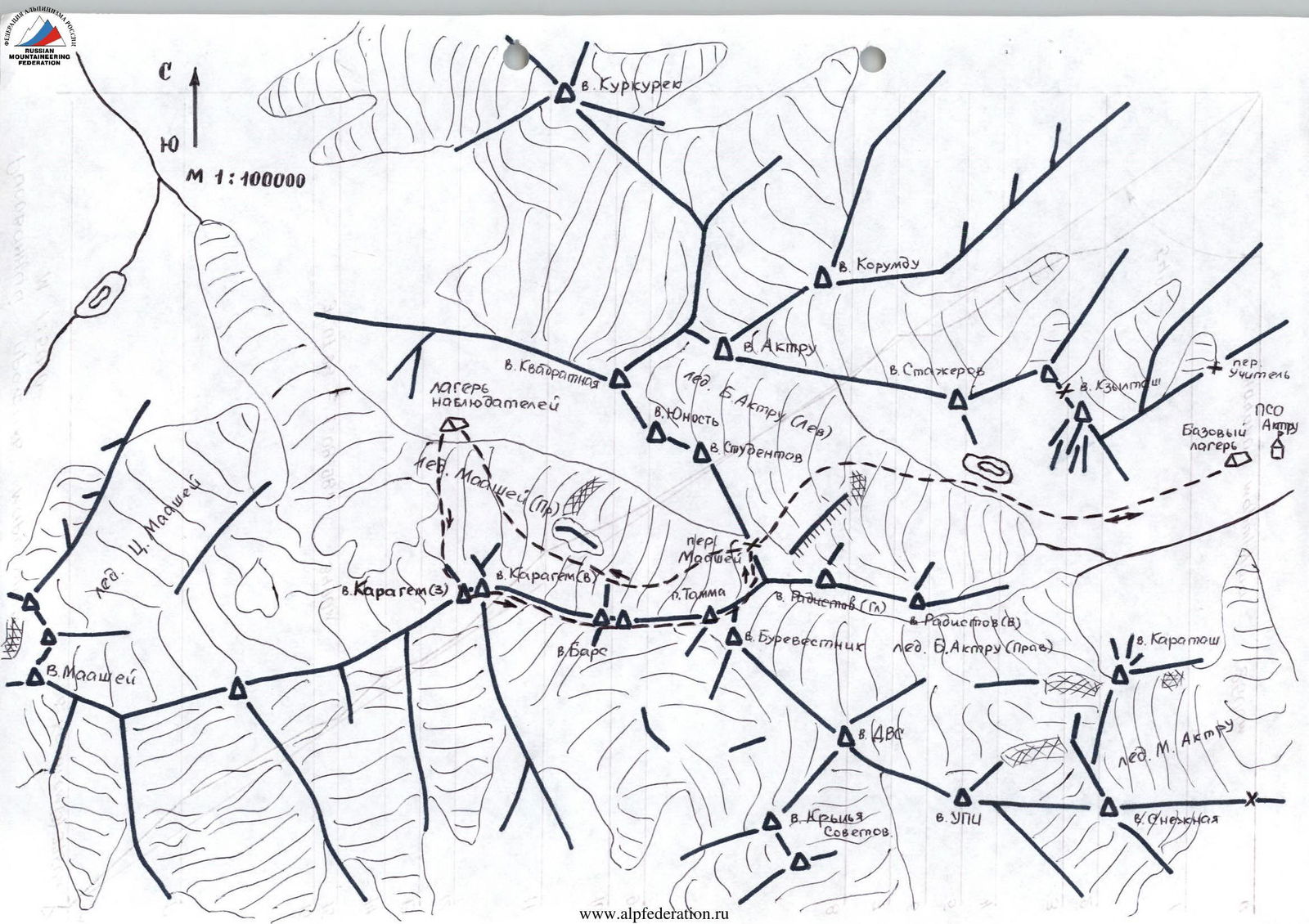
Karagem peak (3972 m) is located in the central ridge of the Severo-Chuyskie Belki, Altai, to the west of Karagem; in the same ridge stands Mt. Maashey (4173 m) — the highest point of the area. To the east, the ridge from Karagem peak goes to Pass Tamsha and further north to Maashey Pass.
To the north, towards the Maashey glacier, Karagem peak drops with a one-and-a-half-kilometer wall. From the left peak of the summit, icefalls hang to the north, separated by rock buttresses. The wall has a northern aspect.
3 routes: 2 — to the eastern summit (4B, 5B), 1 — to the western summit (5B) during the existence of Ak-Tru alpine camp. You can reach the area by the following path: to Biysk by any transport (train, bus). In Biysk, it is necessary to hire a high-clearance vehicle. Follow the Chuya Highway to the village of Chibit (440 km from Biysk). In Chibit, cross the Chuya river and on a poor road, a high-clearance vehicle can travel 10–12 km along the Maashey river. Then move on foot along the trail. The hike from the drop-off point to the foot of Karagem peak takes 5–6 hours. The base camp is located on the moraine of the glacier, 30 minutes' walk from the start of the route.
Another path lies through the Ak-Tru gorge:
- From Biysk to Kurai (480 km) along the Chuya Highway;
- Then 20 km across the Kuraisteppe and 10 km through the Ak-Tru gorge to the PCO;
- A high-clearance vehicle is required for the last 30 km. From the Ak-Tru gorge to Karagem peak, the path lies through Maashey Pass, category 2B. Approach time is 6–8 hours. This path was used by the instructors of Ak-Tru alpine camp. This path was chosen by the team from Rubtsovsk Sports Committee to Karagem peak (3) via the northern wall, category 5B. (V. Andreev).
Preparation for the ascent
The initial material for preparation for the ascent was: a) A copy of the report on the first ascent of the route. b) Reconnaissance and photography done in 1997, during the approach and return from the ascent to Karagem peak as part of the Russian Championship.
The information obtained allowed us to determine the tactics of the ascent and select the corresponding equipment. Considering the unstable weather in this area, the group, planning an ascent with one overnight stay, took a reserve of food and fuel for two additional days in case of a forced wait.
All team members, before departing on the route, made two ascents with participants of the gathering for acclimatization and training in the Ak-Tru gorge area (Kyzyltash peak, Radistov peak, Trainees peak).
The ascent was made in a different gorge, so an observer group was organized, consisting of 4 people with communication means and equipment to provide assistance if necessary. The observers were in a camp under the start of the route. Interaction with Ak-Tru Rescue Team was also organized.
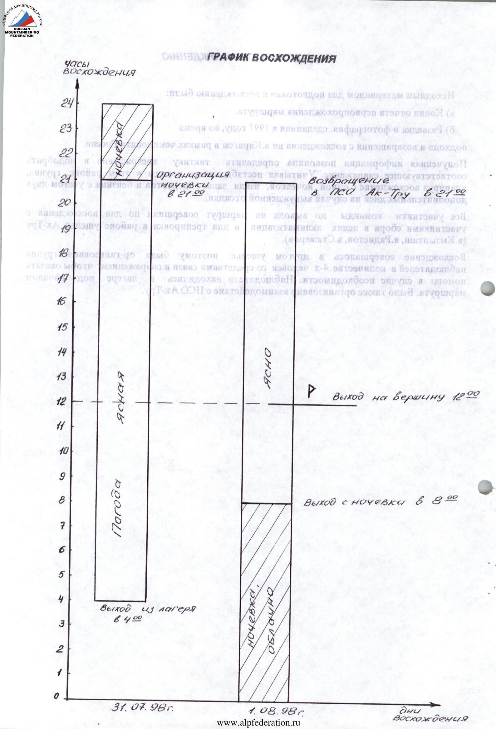
July 31, 1998.
Tactical actions of the team
The passage of the route to Karagem peak was carried out within the framework of the tactical plan, taking into account bad weather. The route took 29 hours. Organization of rope team movement and their interaction according to the tactical plan. On all sections of the route, piton belays were used; the first team to work was E. Vinnikov, V. Sergeev. All participants moved on fixed ropes with belays. Difficult sections were passed on double ropes using artificial climbing techniques. The heavily destroyed rocks on the route greatly complicated the passage of steep sections. The first climber had to be extremely cautious during movement and organization of belay points.
The weather was stable, clear. Radio communication sessions — according to the route sheet. Communication with observers was maintained via the "ASCOM" radio station. Observers were located within 30 minutes' walk from the start of the route. There were no falls or injuries among the team.
Table of food products and fuel.
| # | Name | Weight (kg) |
|---|---|---|
| 1 | Sausage | 1.0 |
| 2 | Lard | 1.0 |
| 3 | Chinese noodles – 10 packs | 0.7 |
| 4 | Canned fish – 6 cans | 1.5 |
| 5 | Canned meat – 3 cans | 1.2 |
| 6 | Rusks | 1.0 |
| 7 | Sugar | 0.5 |
| 8 | Tea | 0.1 |
| 9 | Chocolate | 0.9 |
| 10 | Nuts | 0.5 |
| 11 | Raisins | 0.5 |
| 12 | Dry drinks | 0.4 |
| 13 | Stove | 1.2 |
| 14 | Gasoline | 1.2 |
| TOTAL: | 11.9 kg |
Two days of ascent, two reserve days in case of a forced wait.
ROUTE SCHEME IN SYMBOLS 1:2000
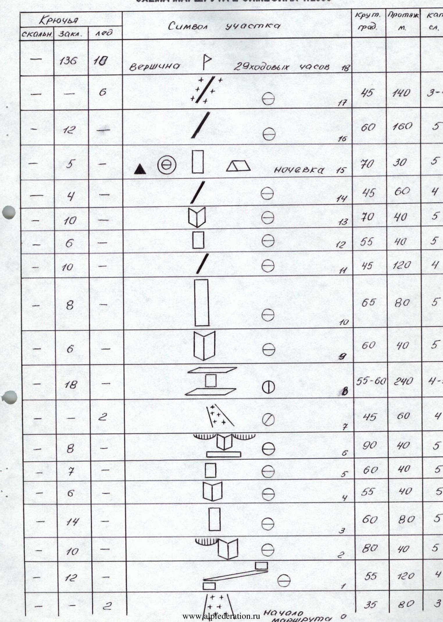
Description of the route by sections
R0–R1. Ice couloir. After the second rope, exit to rocks. At the top, there is a hanging icefall. Simultaneous movement. R1–R2. Series of steep walls and inclined ledges. Belay (piton) through chocks. R2–R3. Internal corner. Organization of fixed ropes. Belay through chocks. R3–R4. Wall. Many loose rocks. Belay through chocks. R4–R5. Internal corner with few handholds. Belay through chocks. R5–R7. Steep wall. Many loose rocks. Exit to a wide ledge, then a very difficult internal corner. Old pitons are found. Belay through chocks. Organization of fixed ropes. R7–R9. Ice-snow couloir passes under a hanging icefall. Requires increased attention and caution. Then a series of ledges and walls. Belay is hampered by heavily destroyed rocks. The most destroyed section on the entire route. R9–R15. At the beginning, an internal corner, then a wall. Heavily destroyed rocks limit the organization of belay. Then a ridge, which abuts a wall, turning into an internal corner, leading again to the ridge. Belay through outcrops and chocks. On the ridge before the wall, a lying overnight stay. Control cairn. R15–R18. Wall is passed by free climbing. Then a rocky ridge, turning into an ice-snow ridge. Belay through chocks, ice axes, rock outcrops.
Throughout the entire route, you can find good places for overnight stays.
Protocol
of the analysis of the ascent to Karagem peak (3) via the northern wall (3750 m) as part of the Russian Alpine Championship, carried out by the team from Rubtsovsk Sports Committee on 31.07.1998 – 01.08.1998.
- Sergeev V.P. — leader. Good access, a large number of routes, as well as a rescue team gives Ak-Tru undisputed advantages over other Altai regions for holding training camps and ascents. Their main task is the growth of young climbers. We planned and scouted the route to Karagem peak (3) via the northern wall back in 1997 during the ascent to Maashey peak. A feature of the route is the presence of two hanging icefalls, which overhang the lower part of the route, as well as heavily destroyed rocks. You need to start the route early in the morning to avoid rockfall. The team completed the ascent in accordance with the tactical plan. On the first day, we reached the planned overnight stay. On the next day, we were at the summit. Descent via the normal route to Maashey Pass. Here we met our observers and at 21:00 descended to Ak-Tru base camp.
- Tumyalis V.V. — participant. This is my first ascent of category 5B in this area. The area is characterized by unstable weather. The length of the route is almost one and a half kilometers, and the heavily destroyed rocks require increased attention and extreme caution from the participants during movement and organization of belay. All this quickly tires. The route was passed at a good pace and according to the tactical plan.
- Vinnikov E.A. — participant — worked as the first. I passed the entire route by free climbing. I had to move very cautiously, especially in the second part of the route. It is the most rockfall-prone due to the heavy destruction of rocks. During bad weather, the complexity of the route increases significantly. But we were lucky, and we completed the ascent in good weather. There were no comments from the team regarding movement and organization of belay.
- Semenov E.B. — observer. We were located just 30 minutes' walk from the route. Almost the entire route was visible from our camp. The team made radio contact according to the route sheet. On the second day, after receiving a radio signal that they had started their descent, we went to meet them at Maashey Pass, and then descended together to Ak-Tru.


