10 173 2А
- Class - first ascent.
- Altai, Severo-Chuysky ridge, Karakabak gorge.
- V. Dvoynaya (C) via the northern ridge.
- Proposed 2A cat. difficulty (first ascent).
- Height 3480 m, elevation gain 540 m, length 1250 m, average slope 25 °.
- 11 hours of climbing time (from camp to camp).
- Overnight stays - no need.
- In a team of two: Drakin A. V., CMS; Okhremenko I. N., 1st sports category.
- Coach Drakin A. V., 1st category No. 68.
- Date of ascent August 27, 1999.
- Organisation - Altai Regional Alpine Federation.
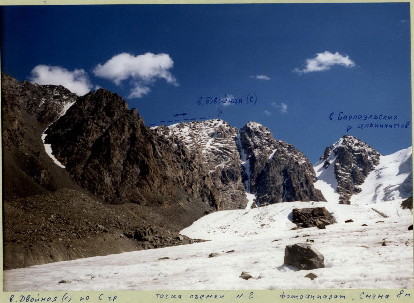 View of the summit Dvoynaya (C) from the N ridge. Shooting point No. 2. Camera "Smena 8M", lens LOMO T-43 4/40.
 View of the summit Dvoynaya (C) from the N ridge. Shooting point No. 1. Camera "Smena 8M", lens LOMO T-43 4/40.
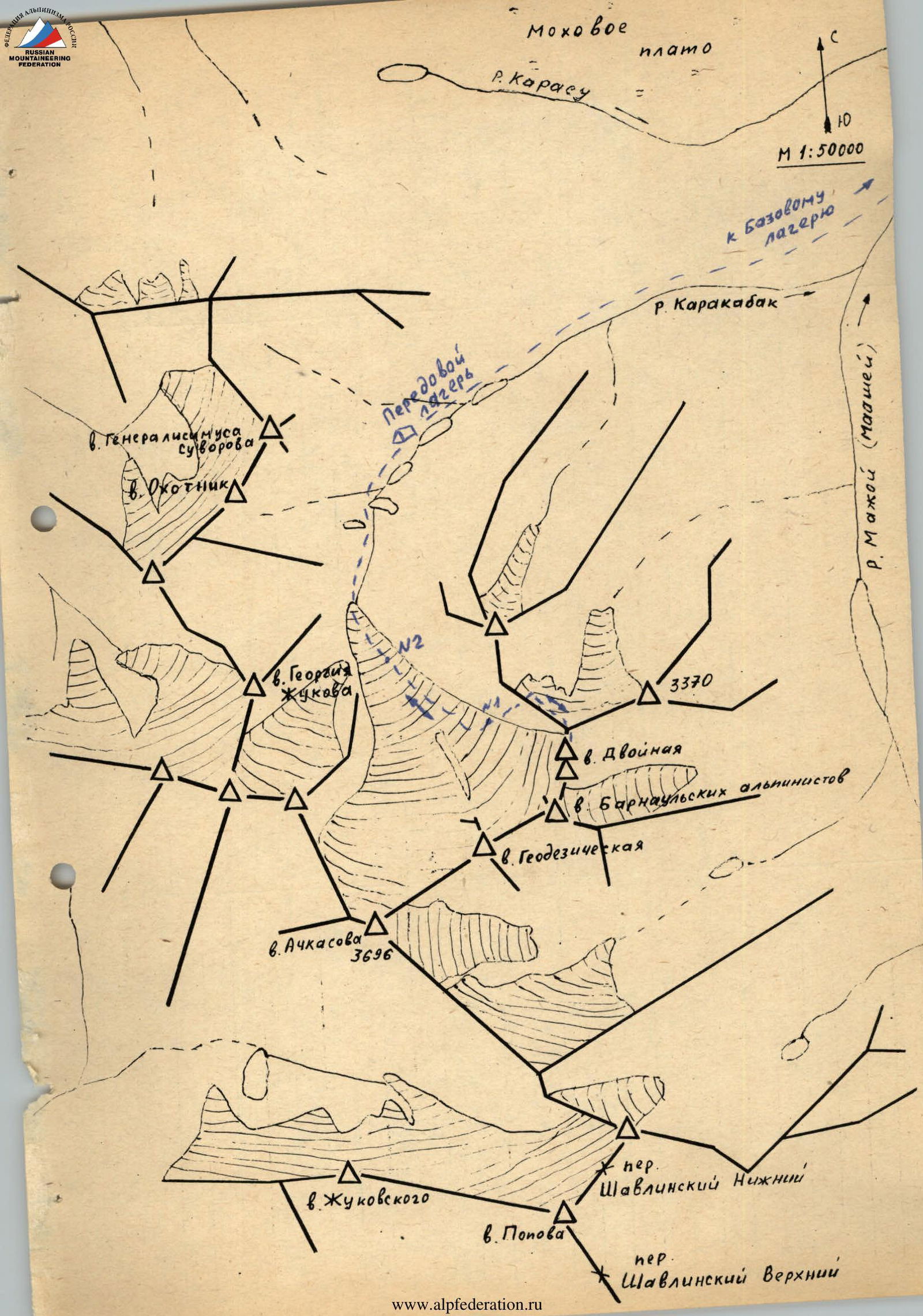 Map of the climbing area.
Brief description of the area
The Karakabak River is a left orographic tributary of the Mazhoy (Maashey) River. Different maps may have different names for this river. Mazhoy and Mashey are found on topographic maps. Moreover, the name Makhoy is more common. The name Maashey is predominantly found on tourist maps.
Encountered names:
- Makhoy - more common, present on topographic maps.
- Maashey - predominantly on tourist maps.
Access to the area is via the Chuy tract to the village of Chibit. In Chibit, turn off the Chuy tract and then drive along the Chuya River for 15 km to the mouth of the Mazhoy (Maashey) River. At this point, there is a road bridge across the Chuya. Cross the Chuya, overcome a steep climb with hairpin bends and drive along the valley of the Mazhoy (Maashey) River to the upper zimovye. There is no road beyond this point.
The section from the village of Chibit to the upper zimovye can only be traversed by a high-clearance vehicle.
From the zimovye to the upper reaches of the Karakabak River, one can proceed:
- along the Karakabak River, ascending a forested slope;
- via a small ridge separating the Karakabak River valley from the swampy plateau.
Above the forest zone along the river, there is a series of lakes. The approach to the lower lake takes 2-3 hours from the upper zimovye.
An expedition of climbers from Barnaul set up a base camp near the upper zimovye and a forward camp above the second lake. All ascents were made from the forward camp.
The area is rarely visited by climbers. Although climbers have been to most of the high and prominent peaks. Cairns with notes have been built. Climbs were made in 1976 and 1982 by climbers from the Lokomotiv sports society from Novosibirsk and Barnaul.
Apparently, reports were not submitted to the classification committee. Although a report was submitted for the route to the summit of Achkasova.
V. Dvoynaya (C) via the northern ridge
From the forward camp, located above the second lake, move upstream along the river, bypassing the third and fourth lakes to a moraine rampart blocking the Karakabak River valley. Climb onto the rampart and continue along the river to the tongue of the glacier. Reach the glacier and move along it to the talus slope of the northern ridge of the summit Dvoynaya (C). Approach time is 3-3.5 hours.
On the slope, talus gullies alternate with rock walls. The ascent begins in the direction of a long gully leading left of the depression in the northern ridge of the summit Dvoynaya (C). To enter the gully, it is necessary to overcome a 30 m rock step. Move alternately with protection via a projection.
Ascend the talus gully to its upper part and traverse to the neighbouring gully on the right via a rock ridge. Movement along the rock ridge is alternate, with protection via a projection. The right gully leads to the depression in the northern ridge of the summit Dvoynaya (C).
Further movement follows the ridge. On the ridge, there are two ice pitches:
- The first is 20 m, the second is 45 m.
- Their steepness is 35-40 °.
- They are traversed alternately with protection via ice screws.
A straightforward ridge then leads to the summit.
Descent is via the ascent route.
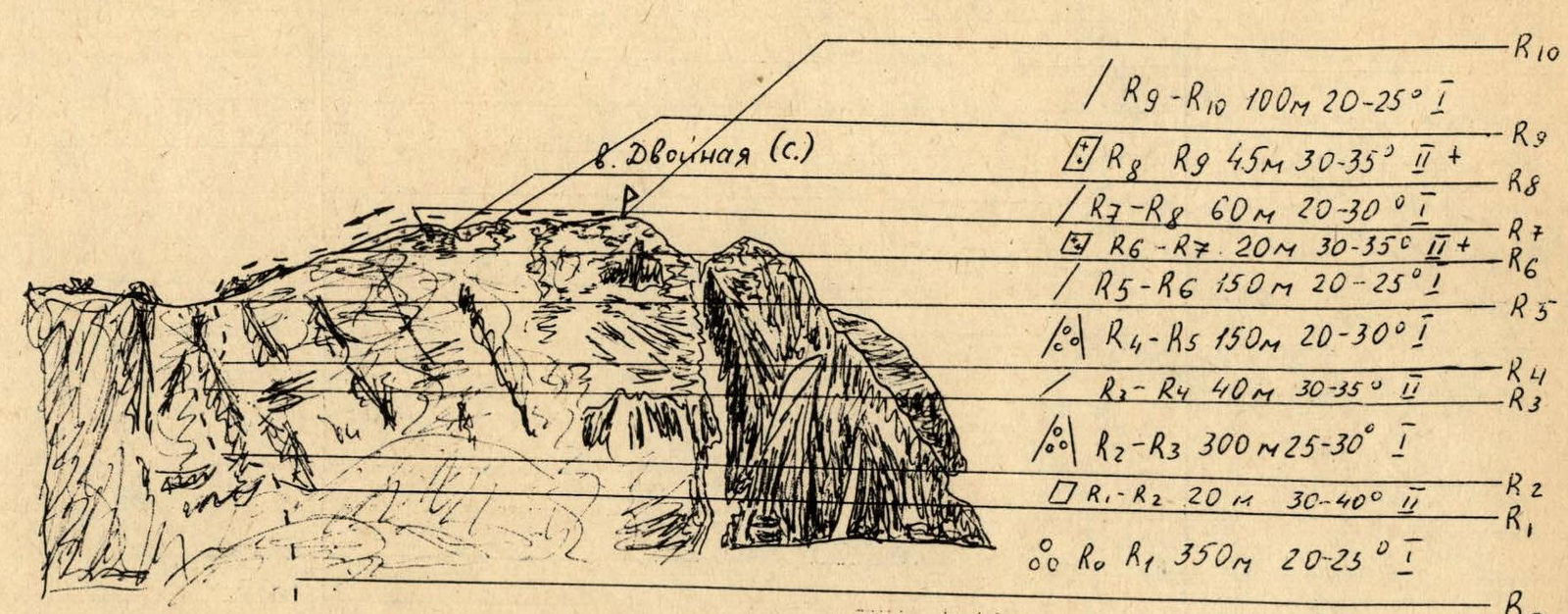
Description of route sections
- R9–R10: 100 m, 20–25 °, 1
- R8–R9: 45 m, 30–35 °, 2+
- R7–R8: 60 m, 20–30 °, 1
- R6–R7: 20 m, 30–35 °, 1+
- R5–R6: 150 m, 20–25 °, 1
- R4–R5: 150 m, 20–30 °, 1
- R3–R4: 40 m, 30–35 °, 2
- R2–R3: 300 m, 25–30 °, 1
- R1–R2: 20 m, 30–40 °, 2
- R0–R1: 350 m, 20–25 °, 1


