
5р. 529, № 9 22/XI–83 55 п/м Петрашко
Brief Overview of the Climbing Area
I. Climbing Object
The peak XX let Oktyabrya is located next to the Belukha massif and to the right closes the so-called Akkemskaya wall. To the northeast of the peak stand out pronounced pre-summit gendarmes, one of which is reached by the route taken by the team. Further to the northeast, the ridge leads to the peaks:
- Urusvati,
- Yu. Rerikh,
- N. Rerikh.
To the southwest of the peak is a snow-firn plateau adjacent to Western Belukha. The overall orientation of the peak massif is northeast-southwest. In June-August.
The climate in the climbing area in June-August is mostly rainy. According to long-term observations, the most favorable weather for climbing is in March and September.
Unfavorable climatic conditions, inaccessibility, and relatively low altitude of the area determine the low attendance of the area. Although it should be noted that the area is promising in terms of the presence of interesting "unclimbed" routes and peaks up to 4200 m high. The path to the described route starts from Barnaul, through Gorno-Altaisk, Ust-Koksa, which can be reached by plane on a local airline. From Ust-Koksa to Tyungur, there is a bus (84 km). From Tyungur to Akkem Lake, you can only get by pack transport on a mountain trail, having previously overcome a forested pass on a mountain taiga road. This 58 km path is traveled with pack transport in three days. The second option is a helicopter, but due to prolonged bad weather, it can be expected for 10 days. We crossed the pass to Akkem valley from Kucherlinskoe Lake by geologists' car to the "kosh". Then all the cargo was carried to Akkem Lake on foot for 5 hours (in 3 trips) as we were unable to obtain horses due to the field work in the kolkhoz. However, we got excellent acclimatization.
The area around Akkem Lake (altitude 2000 m) is characterized by swampiness (even in dry weather), so there are very few places to set up a base camp. The presence of forest solves the problem of cooking in the base camp.
For staying in the base camp and for approaches, boots are essential.
II. Preparation for the Ascent
II.1. Route Selection
The team received information about this wall from the instructors of the MAL "Altai-82", and was also familiar with the route from photographs of the mentioned wall. It should be said that the initial intention to climb the left counterfort, leading directly to the peak, turned out to be unfeasible - the route is marked on 2/3 of the lower part. This became clear during preliminary observation of the wall from close proximity. As a result, the central counterfort was chosen, running practically along the direction to the main ridge, but 400 meters to the right of the peak.
II.2. Team Preparation
The team's intention to climb a good route in such a beautiful mountain area as Altai had been formed long ago. And only the conditions of the RSFSR championship this year made it possible to implement this. Naturally, the team was prepared for this route based on their long-standing climbing experience, regular winter training, and rock climbing trips near their home, in the Krynka River area. In addition, before coming to Altai, everyone had already completed May or February ascents.
Here in Altai, this proved to be useful, as due to weather conditions, the team made only one training ascent before starting the route. And within a single "window" of 7 days out of 22, the team "rushed through" the route.
As expected from observations, the main difficulty of the route turned out to be in the second half, i.e., at the top. The route is very safe, with not a single stone falling during the four days.
Following a long-established tradition in the team, the progress of each participant, regardless of whether they were leading or following, was ensured by a double rope.
We always take ropes - half domestic for fixed ropes, and half foreign - for belaying.
III. Tactical Actions of the Team
Preliminary observations and inspection of the route revealed the following:
- route length in height: 1300-1400 m;
- the route is mainly rock, except for the lower snow-ice section with a height of 150-200 m;
- average steepness of the route is around 70°;
- character of the rocks: well-jointed monolithic blocks;
- the upper third of the route is the most technically challenging;
- the route is safe and very logical;
- no suitable places for overnight stays were identified during observation;
- a 4-5 m high bergschrund in two places is almost completely covered by avalanche cones, which are pierced by small stones during the day.
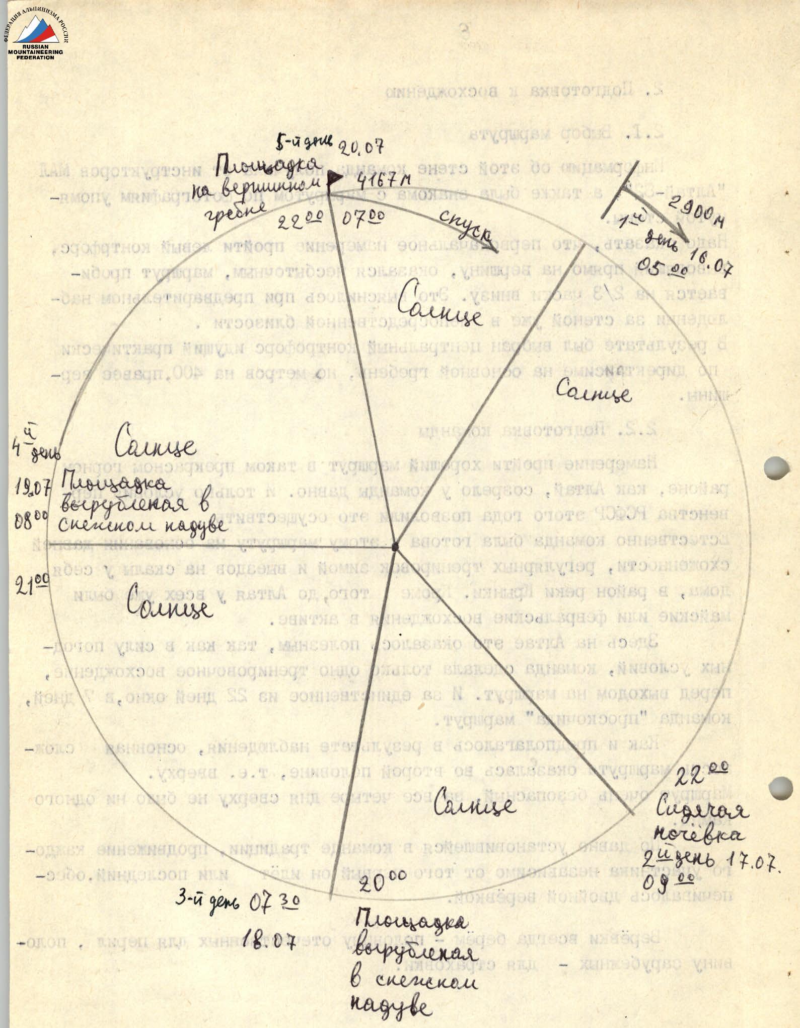
The above determined the team's tactical actions when passing the route and the set of equipment for the ascent (see table on page 12). The route was divided into 4 sections, each of which was supposed to be covered in one day. On the first day, an early start was planned (at 5:00) to overcome the bergschrund and most of the snow-ice section before sunrise and to be under the cover of rocks. For this reason, on the day of the approach, they organized an overnight stay on the glacier within 20 minutes' walk from the bergschrund. Preliminary processing of the route was deemed impractical, as its lower part does not present significant difficulties, and approaching the route during the day is not safe. Belaying of each participant was carried out using a double rope. Given the large number of complex sections (5B, 6 cat. diff.) on the route, it was planned to widely use ascending such sections on fixed ropes with the help of jumar ascenders. The nature of the route did not allow the team to gather in one place during the day, so no special stops for rest and food were planned. Hot meals were provided in the morning and evening at the bivouacs, and each participant received an individual ration for the day.
A team of two observers was constantly on duty under the route, visually monitoring the team with 8x binoculars and maintaining communication with the base camp. Communication between the team and the observers was carried out using a "Vi-talk" radio station 3 times a day + 2 emergency communications. Additionally, the group had 2 signal flares on the route.
Descent from the route is possible only via the ascent route or through the summit and then either along the eastern edge (4A cat. diff.) to the Akkem glacier, or along the northwestern ridge through p. N. Rerikh to the base camp area.
The main provisions of the planned route tactics were implemented. The route turned out to be somewhat more complicated than expected, especially after prolonged bad weather before the ascent, when huge snow drifts in the most unexpected places, often under rock overhangs, significantly hindered progress. Practically the entire wall had to be equipped with fixed ropes. Only in one place (section R3) was it possible to climb in autonomous rope teams. The rest of the wall was traversed by fixing ropes and using jumar ascenders. The use of ascenders, lightweight metal equipment, optimal selection of its quantity and assortment, and correct distribution of food according to the tactical plan - all this made it possible to climb with relatively light backpacks, without pulling them up the route. Only in two places - sections above the first and third bivouacs - did the first climber go without a backpack. For belaying participants, only double ropes were used. The autoclave taken on the route proved to be very helpful, significantly saving fuel and time for cooking. The tactical plan was fulfilled day by day.
On the first day, Shebolkov worked on the ice part of the route first, then Gnoevsky climbed the rock part, and was replaced by Mashchenko at the end of the day. On the second day, Gnoevsky climbed most of the route first, and Mashchenko replaced him on the last three ropes. On the third day, Gnoevsky started the movement, then Varavin took over, followed by Mashchenko. On the fourth day, Mashchenko started first, then Varavin, followed by Mashchenko again, then Gnoevsky, and finally Varavin climbed the last two ropes before reaching the main ridge. Bratsev (first day) and Shebolkov (second to fourth days) were the last in the team.
Movement throughout the days was practically without special stops for rest. Each participant received an individual food ration in the morning and had a flask with water, tea, or fruit drink mixture like "Veloton".
IV. Route Description by Sections
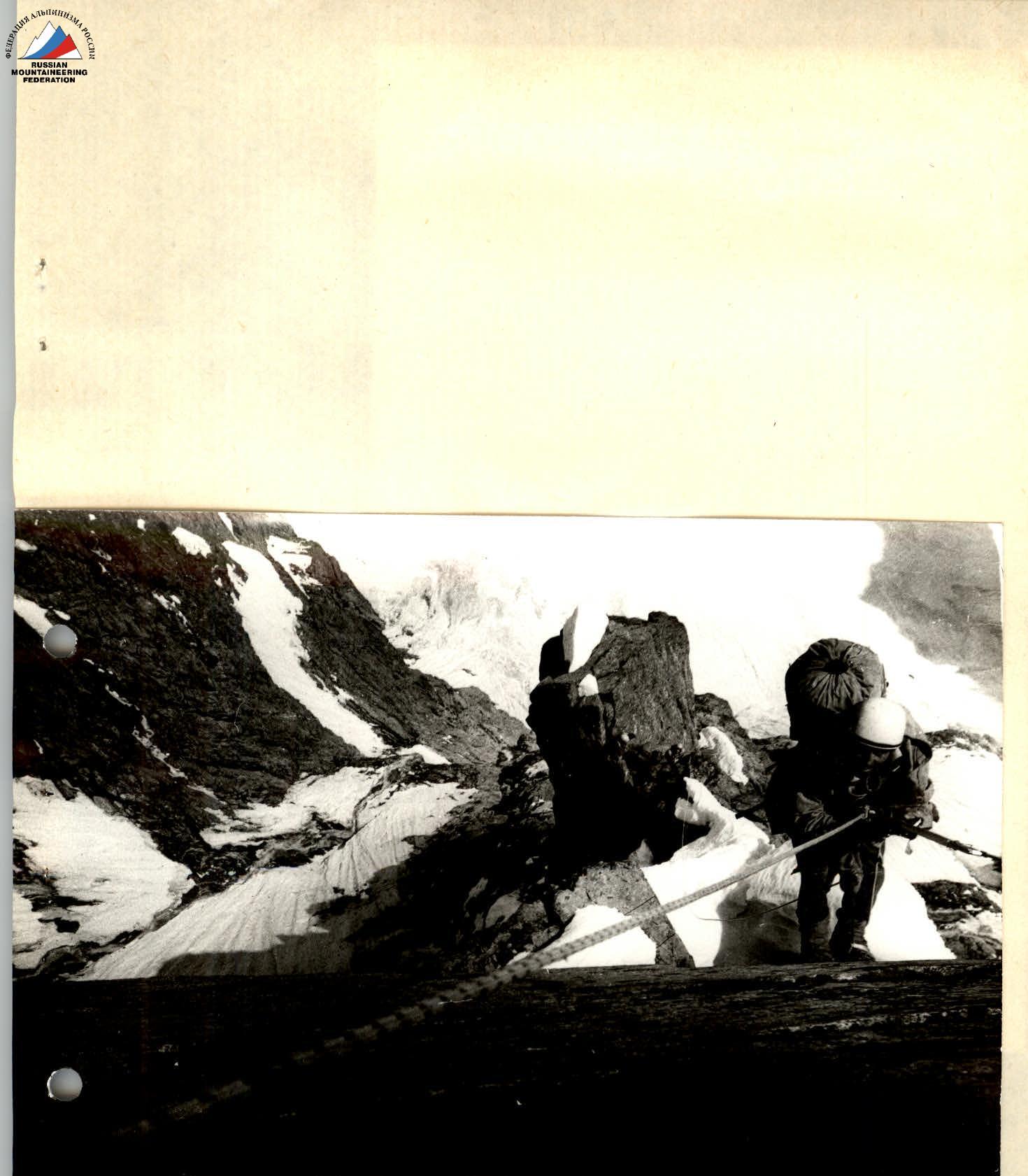
The lower part of the route (section R1) is snow-ice. Its passage does not present particular difficulty. The snow is dense, and the 4-5 m high bergschrund is overcome along one of the avalanche cones. The ice surface is friable, requiring deep holes for pitons. At least one pair of crampons is required per rope team. In the upper part of the section, tying two ropes together may be useful. It is recommended to pass this section very early (before sunrise), as the wall is immediately illuminated, and the section starts to be hit by small stones.
Sections R2-R4 are very logical, passing along a not very pronounced counterfort, which on section R3 crosses a wide inclined ledge leading to the right and upwards. The rocks are monolithic, well-jointed. Section R4 ends before a complex 40-meter wall (section R5), after which a control cairn is left on a small site, the only one on the route, as it is impossible to deviate from it: the wall on both sides of the route is continuously hit by stones.
Section R6 passes along the right "cheek" of the counterfort, 5-15 meters from its edge, along a not very pronounced inner corner, bypassing the rock masses overhanging the edge. The rocks are heavily destroyed, with sharp "feathers" and many "live" stones. This is the most dangerous place on the route. Here, it is advisable to inspect the possibility of transitioning to the left "cheek" of the counterfort approximately in the middle of section R6. Inspection of this route variant from above allowed us to assume that such a variant is safer (and possibly easier). After completing section R6, on a snow drift under a huge rock overhang, there is a small site suitable for a sitting bivouac for 4-5 people.
Section R7 is the most complex part of the route. It is climbed in ladders, without a backpack. The length of the section is 42 meters. From the bivouac site, half a rope length of very complex climbing to the right and upwards along a sheer monolithic wall in the direction of a chimney. The place is very challenging. Here, before entering the chimney, a single bolt piton was hammered in for the route. Further, 20 meters of complex climbing upwards along a wet, and in the upper part covered with ice, chimney lead to an inclined ledge (start of section R8).
Sections R8-R10 pass directly along the counterfort, 2 rope lengths of very complex rocks using artificial aids end with a 25-meter wall of medium complexity, above which there is a small inclined platform with a snow drift, on which, after cutting off its top and compacting, a good site for a tent can be made.
Section R11 - two rope lengths of complex rocks with microrelief pass directly along the counterfort, and then, starting from section R12, the route moves to the left "cheek" of the counterfort and up to section R20 represents a bypass of a rock tower overhanging the edge of the counterfort. The general direction of movement is to the left and upwards on sections R12-R17 and upwards to the right on sections R18-R20.
Sections R12-R13 represent a transition to the left "cheek" of the counterfort along simple rocks, and then, starting from section R14, the actual bypass of the overhanging rock tower begins.
Sections R14-R15 and the beginning of section R16 - 1.5 rope lengths of very complex climbing first along a monolithic inner corner, then after a 10-meter traverse to the left, a complex 20-meter wall is climbed "head-on", followed by a traverse to the right under a small wall turning into an inner corner, which leads to a wide sheer chimney.
Section R16 ends after exiting the chimney before a complex 40-meter wall (section R17), above which is a wet inclined ledge leading to the right and upwards, ending with a small inclined platform with a snow drift under a sheer monolithic wall. By cutting off the top of the drift, a decent site for a tent can be made. In the absence of snow, the bivouac site is inconvenient.
Section R18 begins with the above-mentioned 10-meter sheer monolithic wall. Climbing is very complex, using artificial aids. This is perhaps the second most complex place on the route. Further, the path goes along the left side of the counterfort ridge, along icy, very complex rocks. The general direction of movement is first upwards to the right (sections R18-R20), then directly upwards (sections R21-R24), maintaining the general direction towards the ridge. The most unpleasant place on this part of the route is a 10-meter chimney with a cold "shower" on section R19, and the most dangerous is a 60-meter inner corner on section R21 due to the presence of many "live" stones that can be dislodged by those ahead. Falling snow cornice fragments and snow lumps from snow drifts also pose a certain danger.
Sections R23-R24 initially steep, and then increasingly gentler rocks, after a not very pronounced chimney (live stones) lead to a snow-ice ridge with a steepness of 45° and a length of 80 meters, leading to the main ridge of the peak.
The descent from the peak along the eastern edge to the Akkem glacier does not present difficulties.


Comments
Sign in to leave a comment