
II. Passport
I. Rock class.
-
Altai, Katunsky ridge.
-
Peak 20 let Oktyabrya, 4188 m, via the right part of the E. wall.
-
Complexity category 6A, third ascent.
-
Elevation gain 1100 m, length of 6A–6B category sections — 300 m, average steepness of the main part of the route — 60°/3100–4100 m.
-
Pitons hammered:
| rock | nuts | ice screws |
|---|---|---|
| 47 | 174 | 26 |
| 15 | 10 | 0 |
-
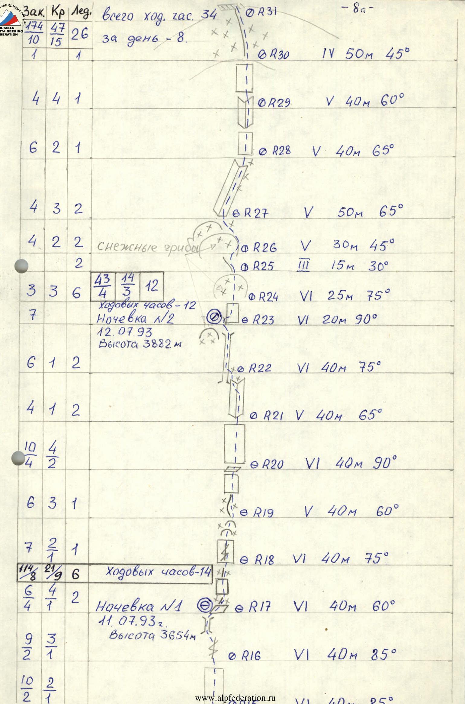
Climbing hours 34, days 3.
-
Overnights: semi-reclined, in tents.
-
Leader: Balevin Valeriy Viktorovich, Master of Sports of International Class. Team members:
- Kokhanov Valeriy Petrovich, Master of Sports
- Kuznetsov Pyotr Valentinovich, Master of Sports
- Pushkarev Semyon Alekseyevich, Master of Sports
- Sagan Sergey Anatolyevich, Candidate for Master of Sports
- Kozyrenko Yevgeniy Viktorovich, 1st sports category
-
Coach: Zakharov Nikolay Nikolayevich, 2nd sports category.
-
Departure to the route: July 11, 1993. Summit: July 13, 1993. Return: July 14, 1993.
-
Organization: Krasnoyarsk Kraysportkomitet.
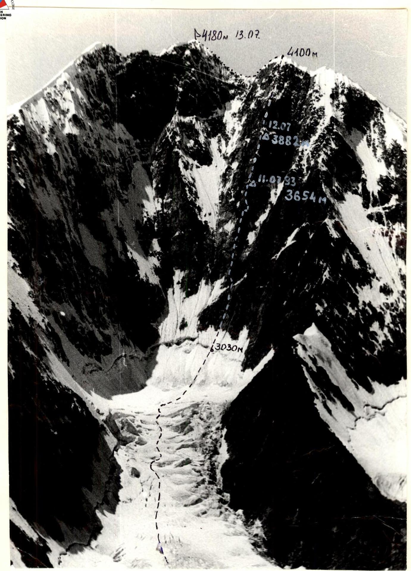
General photo of the summit. Taken on July 7, 1992 at 12:00. Lens "Industar", Φ = 50 mm. Distance 2 km. Height 3100 m.
Brief overview of the climbing area
Peak 20 let Oktyabrya is located in the Katunsky ridge of the Altai Mountains near the Western peak of Belukha. The Belukha area has significant glaciation, with the snow line at an altitude of 2700–2800 m. Altai is known for its unstable weather, with a large amount of precipitation in the summer. The Akkem valley area and the Belukha massif are well-researched and documented in geographical and mountaineering literature, frequently visited, but challenging routes are rarely climbed, likely due to adverse weather conditions.
The base camp is located on the shore of Lake Akkem. The journey to the base camp from the village of Tungur, situated on the Katun River, takes 2–3 days. Cargo is typically transported using horses or helicopters.
The village of Tungur can be reached by bus from:
- Biysk,
- Gorno-Altaisk,
- Ust-Koksa district center.
Approach to the route: from the base camp, ascend the Akkem valley along the left bank of the lake, then cross the river to its right bank. Via moraine — exit to the Akkem glacier. The glacier is calm, gentle, and open, making it convenient for walking. Before reaching the icefall, turn right into the cirque of the E. wall of Peak 20 let Oktyabrya. At the beginning of the medial moraine — overnight stays. From the base camp to the overnight stays — 5 hours of walking. The approach from the overnight stays to the start of the route takes about 1.5 hours. The approach is via a relatively straightforward icefall of the E. wall cirque, with a closed glacier.
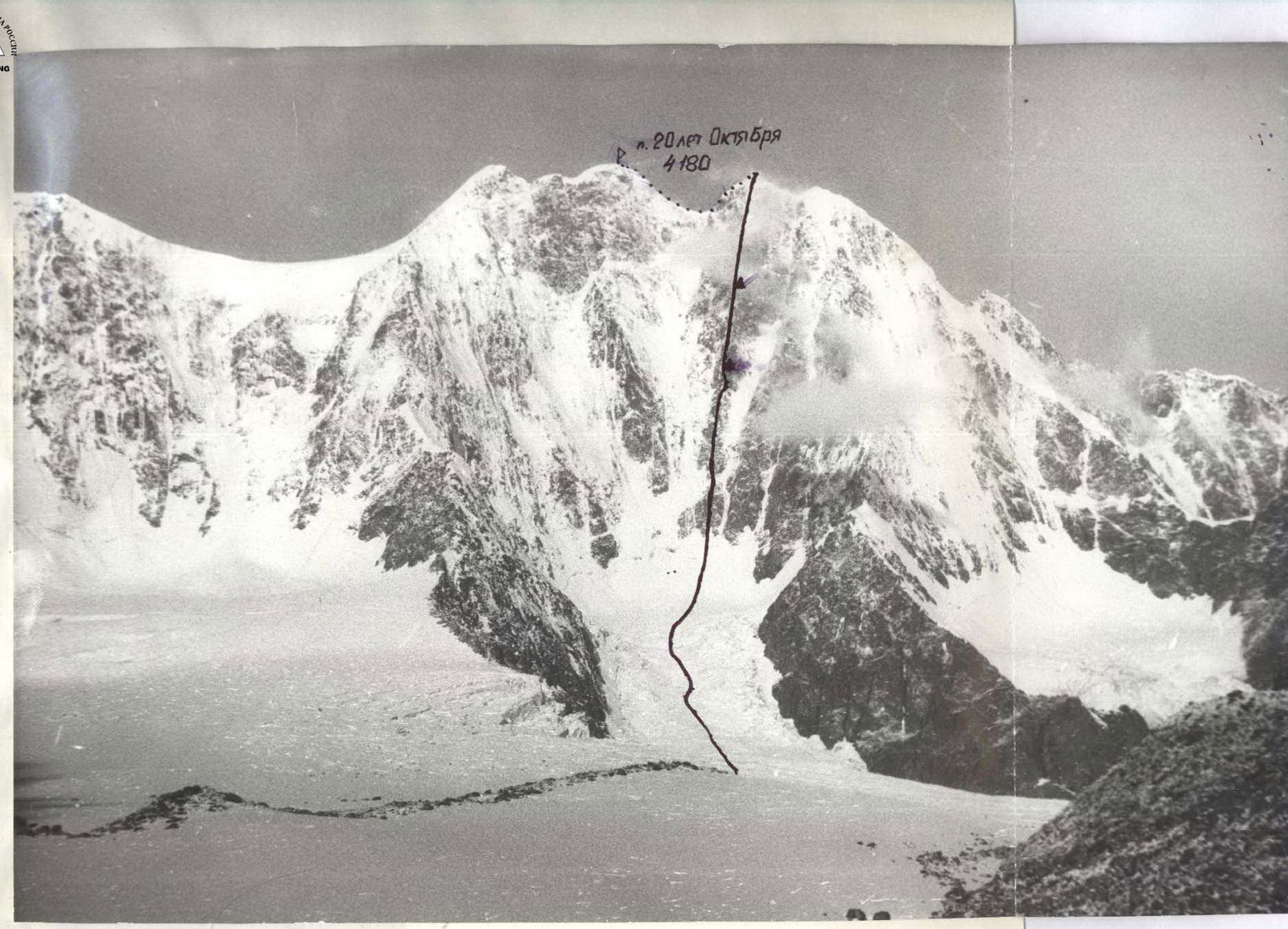
Panorama of the climbing area. Taken on July 9, 1993 at 9:00. Lens T40, Φ = 40 mm. Distance 2 km, height 3000 m.
Tactical actions of the team
The team began moving along the route at 5:00 on July 11. The section R0–R4 had to be traversed early in the morning, as it becomes exposed to rockfall from 10:00. The first rope team was Balevin—Kuznetsov. On snow and ice, Kuznetsov led, while on rocks, Balevin led. The team covered the hazardous section in 2 hours and reached the ridge by 7:00, which was relatively safe: the route was logical, climbing was challenging but free. On the R12–R13 section, a 25 m pendulum was used to bypass a large cornice to the right. The first climber always worked on a double rope, while the others followed on fixed ropes with two jumar clamps, and on rockfall-prone sections, they used additional top-rope protection. Belay points were established on at least three grouped anchors. Mainly nuts were used as anchors, less frequently — pitons, and on ice — ice screws. By 17:00, they reached a good ledge, where an overnight stay was planned. The overnight stay was safe, protected by a rock wall. They covered 40 m of a not-too-steep but very difficult ridge. In the evening, snowfall began and continued throughout the night.
On the next day, July 12, the first rope team to move was Kokhanov—Kozyrenko, with Kuznetsov bringing up the rear. The weather was unstable throughout the day, with several snowfalls. The route featured frequent alternation between challenging rock and snow sections, requiring changes in footwear or crampons, which slowed the pace. By 19:00, they reached the location for the second overnight stay. The platform for the tent was fashioned from snow on a "mushroom," a safe location, with the tent and all team members secured on fixed ropes. During the preparation for the overnight stay, the rope team processed a very challenging section.
On the following day, they departed at 8:00. The first to move were Pushkarev—Sagan. A significant amount of time was spent navigating through snow "mushrooms." The route was heavily snow-covered despite its steepness. By 17:00, the team reached the summit, only 1 hour behind their tactical plan.
All team members performed competently, with excellent physical and technical preparation. There were no falls or injuries. The route was completed with a substantial reserve of physical strength.
Communication with observers was regular, as per the schedule. Along with the observers, a rescue team was stationed on the moraine below the route. Meals were hot in the morning and evening, with individual cold rations during the day.
Product table
| Name | Quantity |
|---|---|
| 1. Fried meat | 0.4 kg |
| 2. Smoked sausage | 0.6 kg |
| 3. Lard | 0.5 kg |
| 4. Crackers | 0.5 kg |
| 5. Dried apricots | 0.2 kg |
| 6. Raisins | 0.2 kg |
| 7. Sublimate cottage | 0.3 kg |
| 8. Sublimate potatoes | 0.3 kg |
| 9. Sports drinks | 1.0 kg |
| 10. Candies | 0.5 kg |
| 11. Tea | 0.1 kg |
| 12. Condensed milk | 1.5 kg |
| 13. Sugar | 0.5 kg |
| 14. Soups | 1.0 kg |
| 15. Onion | 0.1 kg |
| 16. Garlic | 0.1 kg |
| 17. Bell pepper | 0.2 kg |
Total weight of products 8.0 kg.
The total weight of the team's backpacks at the start of the route was approximately 60 kg.
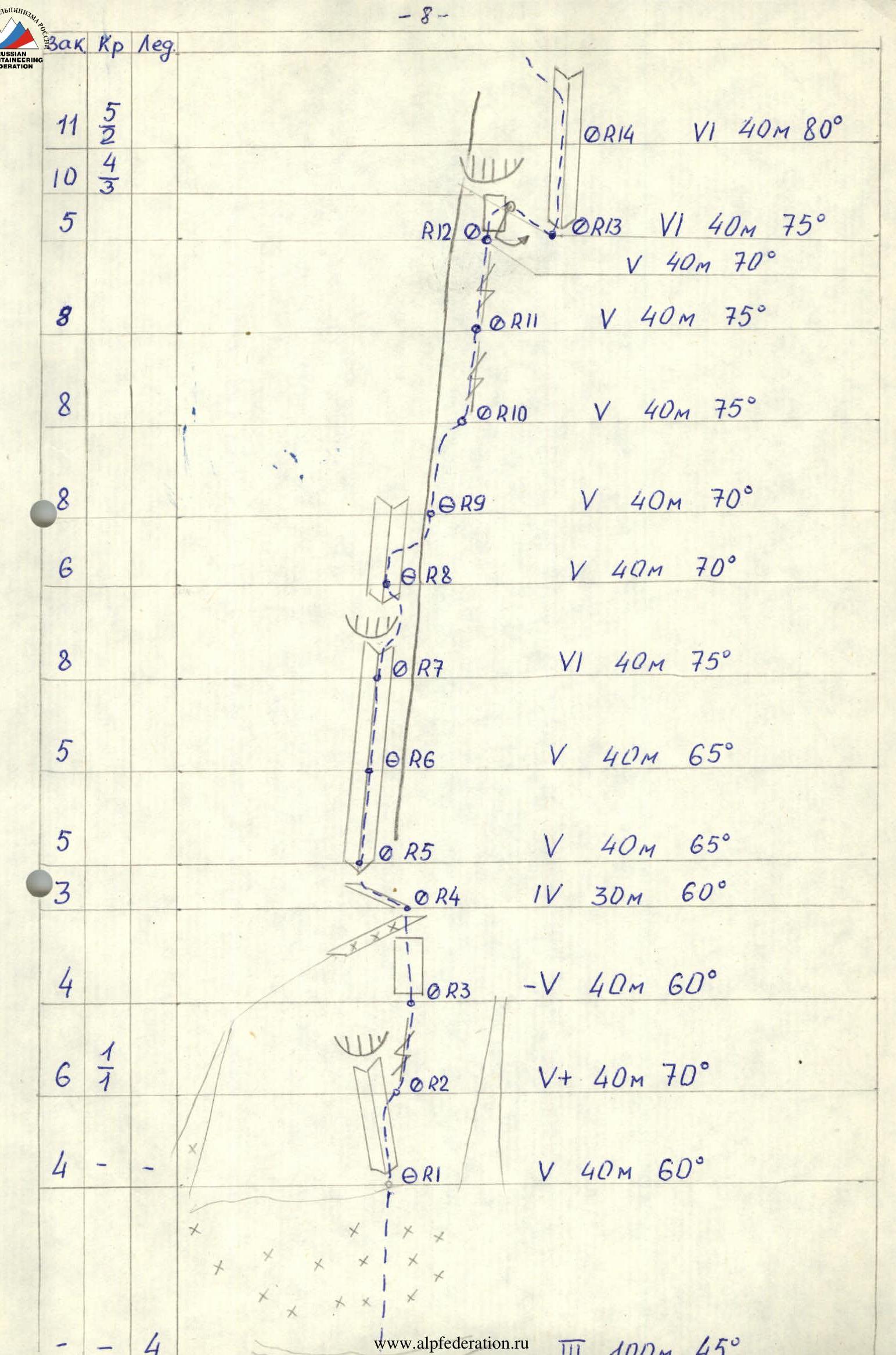
Technical characteristics of sections
- R0: III, 100 m, 45°
- R1: V, 40 m, 60°
- R2: V+, 40 m, 70°
- R3: V, 40 m, 60°
- R4: IV, 30 m, 60°
- R5: V, 40 m, 65°
- R6: V, 40 m, 65°
- R7: VI, 40 m, 75°
- R8: V, 40 m, 70°
- R9: V, 40 m, 70°
- R10: V, 40 m, 75°
- R11: V, 40 m, 75°
- R12: V, 40 m, 70°
- R13: VI, 40 m, 75°
- R14: VI, 40 m, 80°
- R15: VI, 40 m, 85°
- R16: VI, 40 m, 85°
- R17: VI, 40 m, 60°
- R18: VI, 40 m, 75°
- R19: V, 40 m, 60°
- R20: VI, 40 m, 90°
- R21: V, 40 m, 65°
- R22: VI, 40 m, 75°
- R23: VI, 20 m, 90°
- R24: VI, 25 m, 75°
- R25: III, 15 m, 30°
- R26: V, 30 m, 45°
- R27: V, 50 m, 65°
- R28: V, 40 m, 65°
- R29: V, 40 m, 60°
- R30: IV, 50 m, 45°
- R31: (Summit)
Description of the route by sections
- R0–R1. At the start of the section, there is a bergschrund with a vertical ice wall 3 m high, followed by a snow-ice slope.
- R1–R2. Inner corner, traversed on the right side, rocks are damp.
- R2–R3. Rock wall with wide cracks, icy rocks.
- R3–R4. Not too steep but heavily broken rock wall, leads to a snow ledge under a pronounced rock ridge.
- R4–R5. Traverse with a gain in height to the left along broken ledges to the start of a large inner corner.
- R5–R7. Inner corner with a wide gap.
- R7–R8. Inner corner with an overhang in the middle of the section, bypassed on the right. Many "loose" blocks.
- R8–R9. Exit from the corner to the right onto a ridge. Rock ledge.
- R9–R10. Broken rock ridge, at the end of the section, a transition to the right into a large crevice.
- R10–R12. Large crevice, rocks composed of large "loose" blocks, rocks with snow — water flows from the cornice, against which the crevice abuts at its upper part.
- R12–R13. 30 m pendulum from under the cornice to the right into an inner corner.
- R13–R14. Wet inner corner, with artificial handholds used in places.
- R14–R15. Initially a wet and icy inner corner, then a complex transition along steep broken ledges to the left onto the right part of the ridge.
- R15–R16. Monolithic steep complex wall, with good placements for medium and large nuts.
- R16–R17. Steep wall with wide cracks, in the upper part, a transition to the left into an icy chimney. Exit onto a ledge. Overnight stay.
- R17–R18. Snowy and icy ridge with difficult-to-traverse snow "mushrooms" and icy walls. Rocks are monolithic but challenging.
- R18–R19. At the start, a pinnacle is encountered, which is ascended from the left via a vertical wide crack, then wet and snowy ice, very challenging to establish reliable protection.
- R19–R20. Steep rock ridge with snow "mushrooms," exit under a vertical wall.
- R20–R21. Vertical complex wall, with artificial handholds used in places.
- R21–R22. Snowy and icy inner corner, transitioning into a chimney. Many "loose" stones.
- R22–R23. Steep icy wide chimney, abutting a snow "mushroom," which is ascended directly. Requires cutting through a snow cornice. The "mushroom" provides a satisfactory overnight location.
- R23–R24. Steep rock wall with snow cornices, abuts a large snow "mushroom."
- R24–R25. Ascending the snow "mushroom" vertically, requires cutting through an approximately 8 m high snow chimney. Very challenging to establish protection.
- R25–R27. Snow ridge with cornices, which are bypassed on the right.
- R27–R28. Snowy rock corner.
- R28–R30. Alternating between vertical rock walls and snowy slabs.
- R30–R31. Steep snow slope with deep snow, at the top, a cornice about 1.5 m high, exit onto a ridge.
- R31–R32. Snow-ice ridge with rock outcrops. Along the ridge to the summit.
Comments
Sign in to leave a comment