ASCENT CERTIFICATE for Peak XX let Oktyabrya via the NE edge
- Class — technical
- Altai, Katunsky ridge
- XX let Oktyabrya, 4280 m, via the NE edge
- 4B category of difficulty, first ascent
- Elevation gain 850 m, total length of the edge 1900 m, average steepness of the edge 40°
- Pitons driven (for belaying only): rock — 3, bolt — 0, chocks — 0, ice — 31.
- Climbing hours — 10
- Overnight stops on the route — 1 (bivouac)
- Team leader — Meshkov Igor Nikolaevich, Master of Sports Veiko Vadim Pavlovich, Candidate for Master of Sports, Soloboyev Vladimir Evgenievich, Candidate for Master of Sports, Trubnikov Vladimir Ivanovich, Master of Sports
- Team coach — Master of Sports Petrasko Grigory Arsenyevich
- Departure to the route July 23, 1984
Summit July 25, 1984. Return to base camp July 27, 1984
Peak XX let Oktyabrya
NE edge
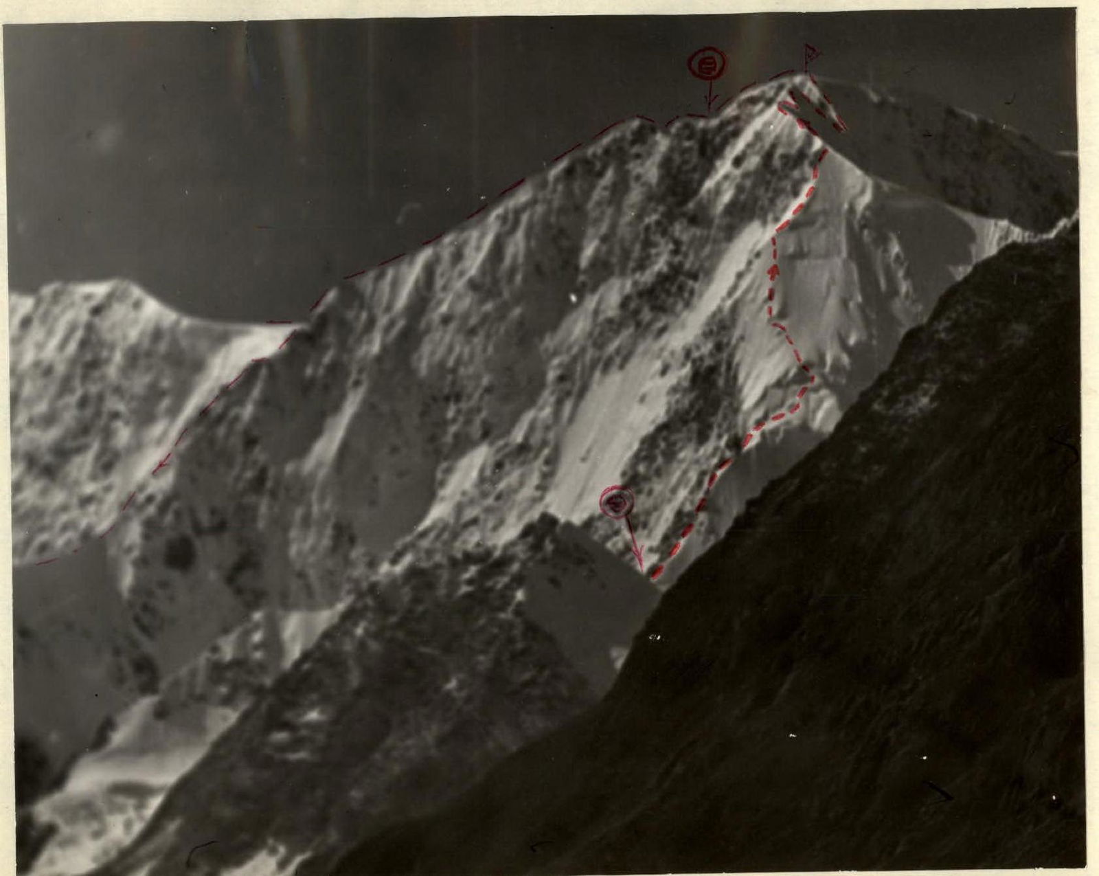
 Massif of Peak XX let Oktyabrya.
Route profile on the NE edge
Massif of Peak XX let Oktyabrya.
Route profile on the NE edge

| Section | Length | Steepness | Category | Description | Pitons |
|---|---|---|---|---|---|
| R1 | 150 m | 35° | III | rocky ridge | |
| R2 | 80 m | 40° | III | mixed ridge, bypassing a gendarme | rock — 2 |
| R3 | 120 m | 35° | III | rocky ridge (rock edges above talus) | rock — 1 |
| R4 | 40 m | 35° | IV | mixed slope | ice — 2 |
| R5 | 40 m | 80° | V | ice chimney | ice — 3 |
| R6 | 280 m | 30° | III | snowy slope, loose snow | ice — 1 |
| R7 | 120 m | 50° | IV | ice slope | ice — 10 |
| R8 | 80 m | 50° | IV | ice slope | ice — 6 |
| R9 | 80 m | 40° | IV | snowy ridge | ice — 2 |
| R10 | 700 m | 30° | IV | mixed ridge with cornices to the gap | ice — 2 |
| R11 | 200 m | 35° | IV | mixed slope with rock outcrops | ice — 3 |
| Total | 1900 m | rock — 3, ice — 28 |
Brief description of the ascent to Peak XX let Oktyabrya via the NE edge.
Approach. From the base camp on Akkem Lake, the approach to the start of the route (saddle of the NE ridge) takes 7–9 hours. Initially, follow the trail to the point where the Akkem River flows into the lake. Here, cross the river (ford or by stones if the water is low).
Then the trail follows the orographic right bank of the river, often getting lost in talus and river branches. Pass by the water gauge post to reach the tongue of the glacier. Continue along the glacier to the level of the NE cirque formed by the NE ridge and the slope of Peak Urusvati. Cross the glacier and ascend to the cirque.
Before reaching the glacier cirque, there is a convenient place for an overnight stop.
Above, there is an icefall that is traversed on the right (in the direction of travel) to reach the plateau of the glacier located in the cirque (beware of crevasses! the icefall and glacier are covered!). The glacier is crossed from right to left in a wide arc, moving under the rocks of the ridge connecting Peaks XX let Oktyabrya and Urusvati (avalanches from the rocks are possible!). From the plateau, ascend to the saddle of the NE ridge (3–5 hours from the overnight stop, depending on snow conditions). There is a convenient overnight stop on the snow at the saddle. The first ascenders processed 200 m of the ridge above the overnight stop.
Sections R1–R2 — snowy ridge, in the upper part of section R2 — bypass (from below to the right) of a rocky gendarme.
Section R3 — movement along the rocky "edge" of a wide ice ridge; the rocks on the left plunge steeply into the Western cirque of the XX let Oktyabrya massif.
Section R4 — crossing a snow-ice slope towards a chain of ice seracs.
Section R5 — ascent onto the seracs via a steep ice chimney.
Section R6 — snowy slope with deep and loose snow (avalanche danger!), belaying only with ice axes. The slope ends with a horizontal ice crevasse — here is a piton.
Sections R7 and R8 — two ice slabs separated by horizontal crevasses. Normal ice climbing.
Section R9 — snowy-ice ridge with gendarmes in the upper part. Exit onto the ridge between Peaks XX let Oktyabrya and Urusvati, passing a cornice.
Section R10 — ridge between Peaks XX let Oktyabrya and Urusvati, with giant cornices to the East, towards Akkem. Movement along a snow-ice slope below the break-off line (extremely cautious — cornices with overhangs of more than 10 m!).
Section R11 — wide pre-summit ridge with rock outcrops leading to a spur connecting the Central and Main peaks of the XX let Oktyabrya massif.
Control point — on the Central peak. From the Central peak, descend southwards, towards Belukha, onto a plateau. Here are convenient overnight stops on the snow.
Descent — via the left ("Studeninsky") buttress onto the Akkem Glacier. The exit to the buttress is at the highest point of the South pre-peak — it is located south of the Central peak on the ridge leading to Belukha and is separated from it by a deep gap.
List of group equipment (4 people):
- Tent "Pamirka" 1 pc. 3 kg
- Stove (with fuel) 1 pc. 1.3 kg
- Ice hammer 1 pc. 1 kg
- Axe 1 pc. 1.5 kg
- Ice axe 3 pcs. 3×1 kg
- Main rope 2 pcs. × 40 m 2×3 kg
- Auxiliary cord 40 m 2 kg
- Rock pitons 10 pcs. 0.7 kg. Note: the number of rock pitons and auxiliary cord is indicated taking into account the descent via the "Studeninsky" ridge.
- Ice screws 12 pcs. 1 kg
- Titanium carabiners 12 pcs. 0.8 kg
- "Jumar" ascenders 3 pcs. 0.2 kg
- Down jackets 4 pcs. 6 kg
- "Karimat" mats 3 pcs. 0.5 kg
- Crampons 12-tooth 4 pairs 4 kg
- Radio 1 pc. 0.5 kg
- First-aid kit 1 pc. 0.5 kg
- Backpacks 4 pcs. 5 kg Total: 36.5 kg


