Passport
- Class — technical
- Pamir-Alay, Turkestan Range, Kara-Su gorge (upper reaches of the Karavshin river)
- Peak "4810", center of the North-West wall (Kritsuk route)
- 6B category of difficulty, third ascent
- Height difference 1210 m Length 1546 m Length of sections 5–6 cat. diff. — 1140 m, Average steepness of the main part of the route — 78° (3600–4660), Sections 6 cat. diff.: 95° (15 m), 90° (370 m), 85° (60 m), 80° (150 m), 70° (80 m)
- Pitons hammered:
| rock | bolt | nuts | holes for sky-hooks |
|---|---|---|---|
| 45 | 9 + 26* | 246 | 30 |
| 15 | 13 | 161 |
* — use of previously hammered pitons and holes for sky-hooks
-
Team's working hours 56 h, days — 7
-
Overnight stays: 1st lying, on a rock shelf; 2nd lying, on a rock shelf; 3rd sitting, five together, one apart
-
Leader: Mikhail Alexandrovich Bruk — CMS Participants:
- Sergey Viktorovich Borisov — Master of Sports of the USSR
- Sergey Lvovich Gerzha — CMS
- Evgeny Vasilyevich Kustov — CMS
- Salavat Zagitovich Khabibullin — CMS
- Valery Amirovich Manirov — CMS
-
Coach: Alexey Veniaminovich Lebedikhin — Master of Sports of International Class
-
Approach to the route: July 7, 1989 Summit: July 13, 1989 Return: July 14, 1989
-
Organization — Sverdlovsk Regional Sports Committee
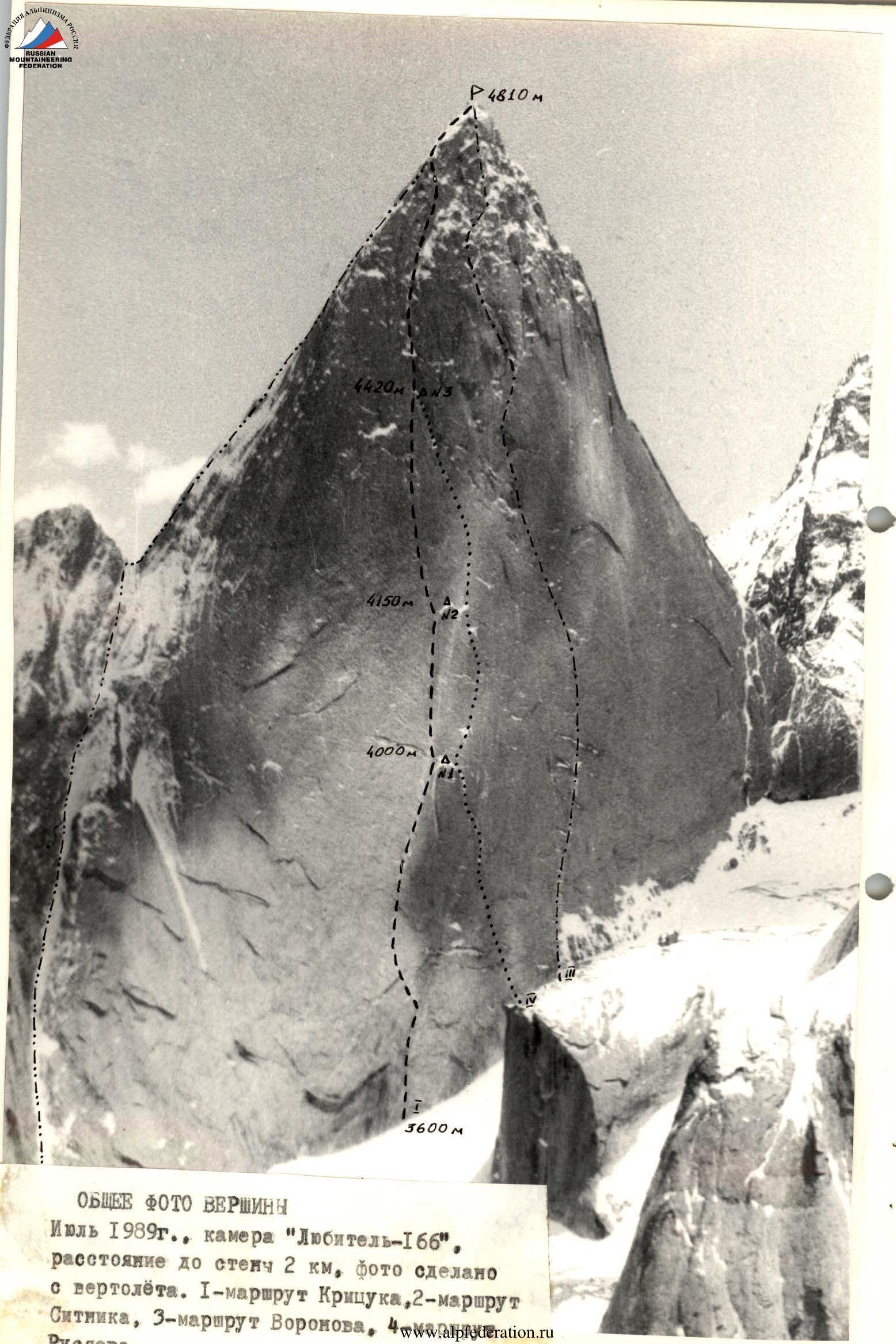
GENERAL PHOTO OF THE SUMMIT
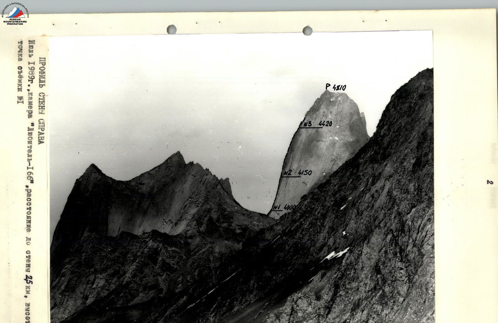
PROFILE OF THE WALL FROM THE RIGHT July 1989, camera "Lyubitel-166", distance to the wall 25 km, height 3500 m, shooting point #1
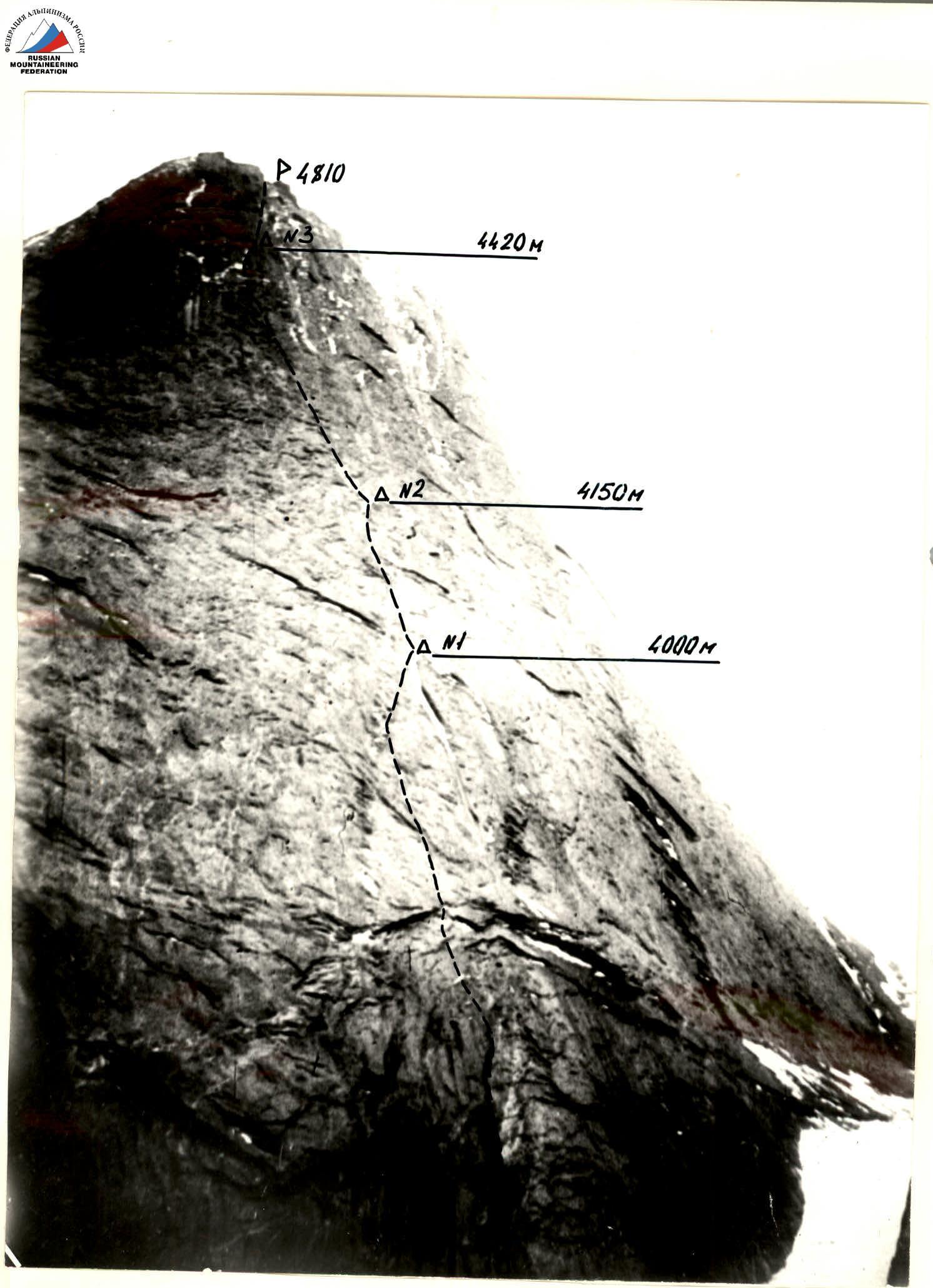
PROFILE OF THE WALL FROM THE LEFT July 1989, camera "Lyubitel-166", distance 1 km, height 3700 m, shooting point #2
 Route diagram in the UIAA system
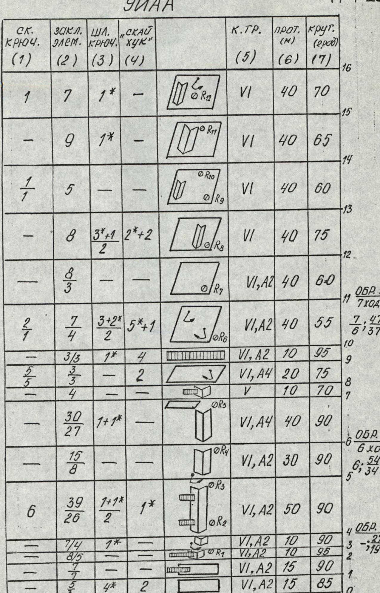
| (1) | (2) | (3) | (4) | (5) | (6) | (7) | Section / Note |
|---|---|---|---|---|---|---|---|
| 3 | 4 | - | - | V+ | 40 | 80° | R0–R1 |
| 3 | 6 | - | - | V+ | 40 | 80° | R1–R2 |
| 3 | 3 | 2 | 2 | V+ | 45 | 75° | R2–R3 |
| 4 | 5 | 3 | 4 | VI A2 | 40 | 80° | R3–R4 |
| 2 | 1 | ||||||
| 4 | 4 | - | - | V+ | 40 | 70° | R4–R5 |
| 4 | 3 | 2 | - | V+ | 40 | 75° | R5–R6 |
| 4 | 3 | 2 | 3 | VI A | 40 | 80° | R6–R7 |
| 5 | 5 | 2 | 6 | VI A | 40 | 85° | R7–R8 |
| 3 | 4 | ||||||
| 4 | 5 | 5 | 12 | VI A2 | 40 | 85° | R8–R9 |
| 2 | 2 | 4 | |||||
| 3 | 4 | 1 | - | VI | 40 | 70° | R9–R10 |
| 1 | 2 | ||||||
| 3+ | 3 | 2 | - | VI A2e | 40 | 85° | R10–R11 |
| 3 | 4 | - | - | V+ | 50 | 80° | R11–R12 |
| 4 | 3 | - | - | V+ | 40 | 70° | R12–R13 |
| 4 | 3 | 2 | 2 | VI A | 40 | 75° | R13–R14 |
| 3 | 2 | 1 | 2 | VI A | 40 | 80° | R14–R15 |
| 4 | 3 | 3 | 2 | VI A1e | 40 | 80° | R15–R16 |
| 10 | 3 | 4 | 8 | VI A2e | 60 | 85° | R16–R17 |
| 2 | 1 | ||||||
| 5 | 2 | 4 | I2 | VI A1e | 40 | 85° | R17–R18 |
| 2 | 1 | ||||||
| 2 | 3 | 2 | 4 | VI A | 40 | 80° | R18–R19 |
| 2 | 1 | ||||||
| 2 | 2 | IX | - | IV | 30 | 60° | R19–R20 |
| 3 | 3 | 2 | 4 | ||||
| 4 | 3 | IX | 3 | VI A | 40 | 80° | R20–R21 |
| IX | |||||||
| -4 | 3 | IX | 6 | VI A | 40 | 80° | R21–R22 |
| 1+IX | IX | ||||||
| 8 | 6 | - | - | VI A | 80 | 85° | R22–R23 |
| 6 | 3 | - | - | V | 40 | 60° | R23–R24 |
| 10 | 5 | - | - | VI A1e | 40 | 80° | R24–R25 |
| 4 | 3 | ||||||
| 4 | 5 | 1 | 3 | VI A | 40 | 80° | R25–R26 |
| 3 | 2 | ||||||
| 5 | 4 | 2 | 4 | VI A | 40 | 80° | R26–R27 |
| 2 | 2 | ||||||
| 6 | 9 | - | - | VI A1e | 40 | 80° | R27–R28 |
| 15 | 8 | ||||||
| 7 | 8 | 2 | 2 | VI A2e | 60 | 80° | R28–R29 |
| 4 | 6 | ||||||
| 3 | 3 | - | - | V+ | 40 | 60° | R29–R30 |
| 3 | 3 | - | - | VI A | 40 | 70° | R30–R31 |
| 3 | 3 | - | - | V+ | 40 | 65° | R31–R32 |
| 3 | 4 | - | - | V+ | 30 | 60° | R32–R33 |
| 2 | 2 | ||||||
| 10 | 10 | - | - | EY | 300 | 50° | R33–R34 |
Team's Tactical Actions
When drawing up the tactical plan for the ascent, we were guided by the time schedule for Kritsuk's team passage, taking into account the increased snowiness of the route.
The main variant of the tactical plan was to complete the route in five days, with one reserve day for bad weather and route conditions. The alternate plan allowed for 1–2 additional days for route processing with a descent to the storm camp.
The weather conditions in the ascent area were extreme. Therefore, one of the main points of the ascent tactics was the choice of a favorable period — a "weather window" and making full use of it.
Another provision on which the team's tactical actions were based was the linkage of the ascent schedule to the overnight stays. Although limited, there were ledges on the route, and the task was to reach them.
The team began processing the route the day after a prolonged period of bad weather, as soon as a satisfactory forecast for the next few days was obtained.
The first few meters showed that the route's difficulty was higher than expected. The cracks and crevices of the hanging giant internal angle were filled with ice, which greatly complicated the organization of protection and minimized free climbing on the rocks.
During the day, intense snow melting began, and work had to be stopped. Under these conditions, 1.5 ropes were processed in the first day for 3 hours of work.
In addition, on the first rope, instead of the expected 10 bolt pitons left by the first ascenders (according to the report), only 4 were found.
Based on the results of the first day's work, it was decided to use the reserve days for processing.
On the second day, there was no radical change in the route's condition, but the weather conditions did not allow for simply sitting under the route. The "window" of good weather could end. On the second day, another 2.5 ropes were covered in 6 hours. However, the main task of processing — to pass the giant internal angle and the big cornice — was not solved.
Without solving it, it was impractical for the team to start the route, as this cast doubt on reaching the initial overnight stay in a day. Therefore, it was decided to continue processing on the third day and start the route as a team on July 10, 1989.
On the third day of processing, the task was accomplished — 3 ropes were covered in 7 hours. On July 10, the team started the route in full force, which was completed in four days according to the tactical plan. The team reached the summit on July 13, 1989, at 17:00.
In terms of physical and technical fitness, the team composition was fairly even. This allowed each participant to work on the route as the first:
- E. Kustov — sections R0–R4, R17–R19, R25–R33
- S. Khabibullin — sections R5–R6, R34–R49
- S. Borisov — sections R7–R11, R20–R23
- M. Bruk — sections R12–R17
- S. Gerzha — sections R24–R25
- V. Manirov — sections R50–R51
The first climber moved on a double rope. One of the ropes was marked UIAA. The second was used as a belay. Everyone else climbed on a fixed rope with two jammers and additional belay, upper or lower. Backpacks were attached to the belt and carried on the back. Every day, the first climber moved in galoshes. For belaying and climbing, the team used the entire arsenal of modern equipment:
- Sky-hooks
- Friends
- Various types of nuts
- Screw-in bolt pitons
During the ascent, movement on the route began at 8:00–9:00. The last participant arrived at the overnight stay no later than 18:00–19:00. The first pair finished the evening processing of the route by 21:00–22:00.
Hot meals were provided:
- In the morning
- In the evening
During the day, all team members received high-calorie "snacks".
A high-altitude arched tent was used for overnight stays.
In the second half of the ascent, the weather deteriorated (temperature drop, strong wind). However, this did not lead to a decrease in the speed of advancement due to the high technical and physical fitness of the participants.
Throughout the ascent and on the descent, a constant and stable radio communication was maintained with the observers. Part of the rescue team was under the route. The main rescue team was in the base camp, with which the observers had stable radio communication.
Description of the Route by Sections
Section R0–R1.
- Smooth wall with sharp fragile holds.
- Bolted route made by the team from Odessa in 1987.
Section R1–R2. Wall with a slight overhang, leading under a cornice with a flake. ITO is used, small nuts.
Sections R2–R4. Along the flake up and right under the overhang, in the middle part — pendulum move to the right.
Section R4–R5. Several meters to the right of the giant internal angle up along the overhanging layers along a wide quartz vein. On the belay station — a bolt, on the bolt — the first control knot (visible from the start). The rocks are heavily destroyed.
Section R5–R6. Pendulum move to the right onto slabs with layers. Water flows. Up to a niche formed by a giant layer and the wall, here — a belay station.
Section R6–R7. From the niche:
- Up and right,
- Then along the overhanging layers in the upper part of the internal angle to a small ledge, where there is a place for an overnight stay.
Sections R7–R9. From the overnight stay:
- Up and right through a small destroyed internal angle onto a slab,
- Pendulum move to the left,
- Exit under a cornice.
Section R9–R10. The cornice is passed using ITO.
Sections R10–R12:
- Gentle monolithic slabs with smoothed holds.
- Free climbing up and left towards a wide quartz vein.
- Limited number of belay points.
Sections R12–R17:
- Along the quartz vein — tense free climbing.
- In the upper part — pendulum move to the right to a flake leading to a large ledge, where there is a good place for an overnight stay.
Sections R17–R19. From the ledge up and left again towards the wide quartz vein, then to the left edge of the system of cornices crossing the wall.
Section R19–R20. From under the cornices up and left. Free climbing alternating with pendulums and ITO movement along flakes. Small nuts are used.
Section R20–R21. Movement up and right towards a ledge with a place for an overnight stay. Strongly smoothed slabs. Free climbing alternates with ITO movement on "heavenly hooks" (sky-hooks).
Section R21–R22. The relief is somewhat richer. Movement is mainly along a crack leading to a ledge with a place for an overnight stay.
Section R22–R23. On the ledge — a bolt, on the bolt — the second control knot. About 7 m straight up from the ledge — free climbing. Then traverse left up towards a large flake. On the ledge of the flake — a belay station.
Section R24–R25. A system of pendulums and traverses. Free climbing and ITO movement left up towards the base of a chimney.
Sections R25–R27. The chimney is passed mainly by free climbing.
Sections R27–R30. Along the system of internal angles and ledges — movement left under the base of a smooth wall with a crack.
Sections R30–R35. A system of vertical walls dissected by cracks. Passed using ITO and free climbing. Monolithic rocks with a minimum number of holds. Sometimes there are:
- Cornices.
Sections R35–R38. An ice-filled chimney leading under a wall ending in a cornice.
Sections R40–R43. A slab with an offshooting crack, tense climbing. The cornice is passed "head-on" using ITO.
Sections R47–R48. A crack passed using ITO on an overhanging slab. Exit to a ledge located 15 m from the pre-summit ridge. There is a good place for an overnight stay.
Sections R49–R51. A simple ridge leading to the summit. Movement is alternating and simultaneous.
Reached the summit 4810. A total of 1760 m covered in 69 working hours. (July 18, 1990)
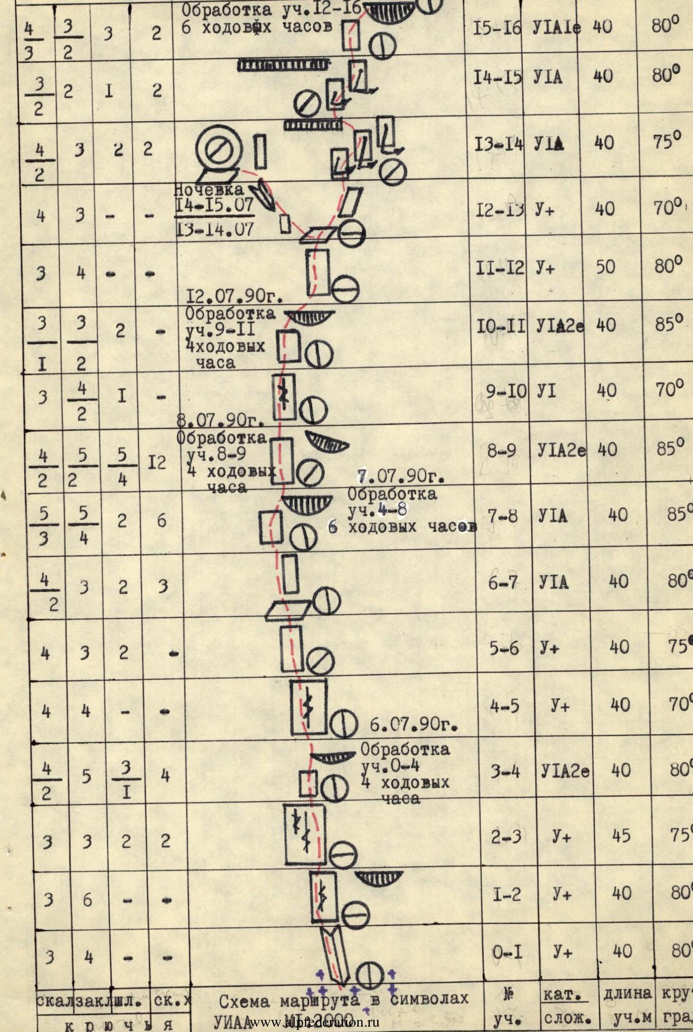
| (1) | (2) | (3) | (4) | (5) | (6) | (7) | Section |
|---|---|---|---|---|---|---|---|
| 3 | 3 | - | - | V+ | 40 | 65° | R31–R32 |
| 3 | 3 | - | - | VI A | 40 | 70° | R30–R31 |
| 3 | 3 | - | - | V+ | 40 | 60° | R29–R30 |
| 7 | 8 | - | 2 | VI A2e | 60 | 80° | R28–R29 |
| 4 | 6 | ||||||
| 6 | 9 | - | - | VI A1e | 40 | 80° | R27–R28 |
| 5 | 8 | - | |||||
| 5 | 4 | 2 | 4 | VI A | 40 | 80° | R26–R27 |
| 4 | 2 | I | 3 | VI A | 40 | 80° | R25–R26 |
| 10 | 5 | - | - | VI A1e | 40 | 80° | R24–R25 |
| 4 | 3 | - | - | ||||
| 6 | 3 | - | - | V | 40 | 60° | R23–R24 |
| 8 | 6 | - | - | VI A | 80 | 85° | R22–R23 |
| 4 | 3 | IX | 6 | VI A | 40 | 80° | R21–R22 |
| 4 | 3 | IX | 3 | VI A | 40 | 80° | R20–R21 |
| 2 | 2 | IX | - | IV | 30 | 60° | R19–R20 |
| 3 | 3 | 2 | 4 | VI A | 40 | 80° | R18–R19 |
| 2 | 3 | 2 | 4 | VI A1e | 40 | 85° | R17–R18 |
| 5 | 2 | 4 | I2 | ||||
| 2 | I | I2 | |||||
| 10 | 3 | 4 | 8 | VI A2e | 60 | 85° | R16–R17 |
| 2 | I | 8 | |||||
| rock piton | nut | bolt | sky-hook | Cat. diff. | prot.m | steep. deg | |
| 3 | 3 | - | - | 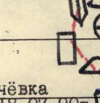 | 29-30 | V+ | 40 |
Total hammered:
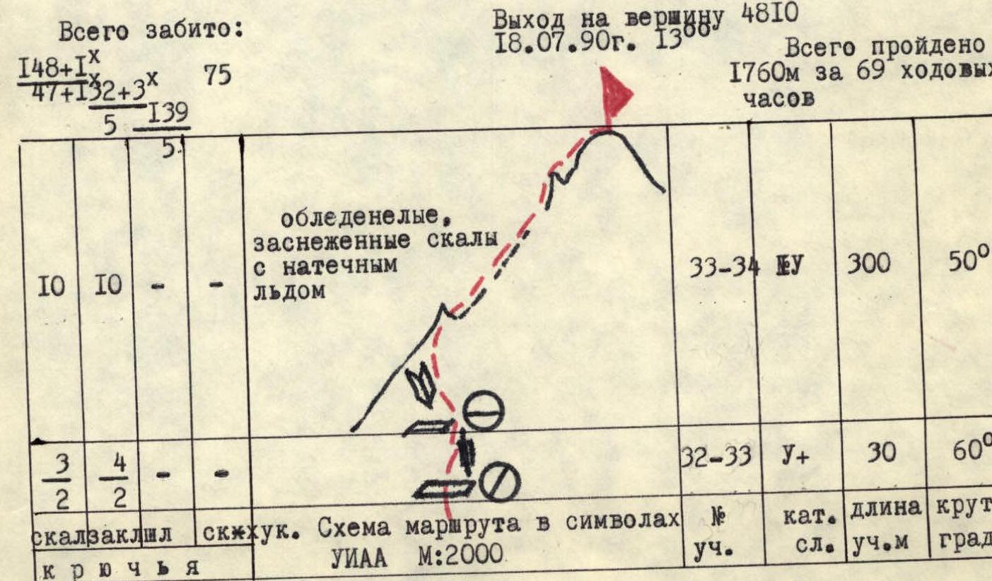
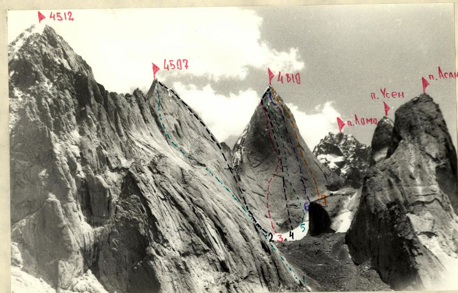
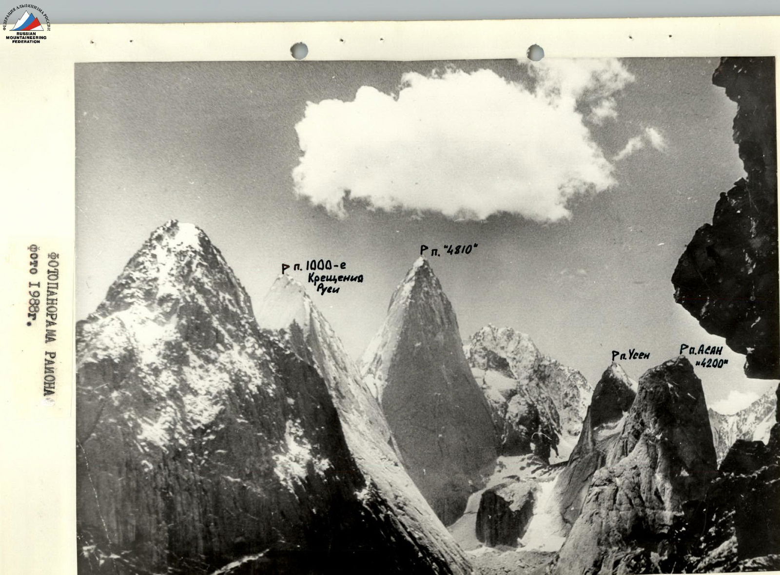
Photo 4. Panoramic photo of the area. Taken on July 22, 1990. Lens "TAKOR" Φ1, height — 3200 m.
- 1 — Skripko route 6A cat. diff. 1988
- 2 — Igolkin route 6A cat. diff. 1988
- 3 — Igolkin route 6B cat. diff., first ascent 1990, category of difficulty is approximate.
- 4 — Kritsuk route 6B cat. diff. 1988
- 5 — Rusyaev route 6B cat. diff. 1988
- 6 — Voronov route 6B cat. diff. 1988
- 7 — Kopeyka route 6B cat. diff. 1988
Description of the Route by Cracks
R1–R3 The route starts from the rank-clutch along the internal angle, passed by free climbing.
R1–R3 — monolithic slab with cracks and flakes, passed by free climbing.
R3–R4 — crack, then a small cornice, belay station on bolt pitons, sky-hooks are used.
R4–R7 — smoothed slabs, wall is wet, climbing is difficult.
R7–R9 — two small cornices in a row, ITO is widely used.
R9–R13 — approach along monolithic slabs under the "bird" cornice, the cornice is passed in the right part, further smoothed slabs. Exit to the overnight stay along the internal angle.
R13–R15 — traverse climbing to the right under a large cornice, "pendulum" technique is widely used to overcome monolithic slabs.
R15–R16 — passage of the cornice on ITO, climbing is difficult.
R16–R20 — monolithic slab with a minimum of holds, extremely difficult climbing, sky-hooks and screw-in bolt pitons are used. Exit to the "chest" overnight stay along a simple internal angle.
R20–R22 — traverse to the left to a chimney using a "pendulum", the wall is wet, climbing is difficult.
R22–R24 — the chimney is passed in a jam, climbing is difficult because the chimney is icy after bad weather.
R24–R26 — a series of internal angles and cracks, after bad weather the rocks are icy, passed on ITO. Exit to the overnight stay.
R26–R28 — monolithic wall, traverse to the right to a crack using "pendulums", due to bad weather, ITO is used.
R28–R29 — crack, then a wet internal angle, exit to the overnight stay.
R29–R33 — along a series of internal angles, exit to the ridge, rocks are covered with rime.
R33–R34 — along the ridge to 4810 m, climbing on icy rocks.
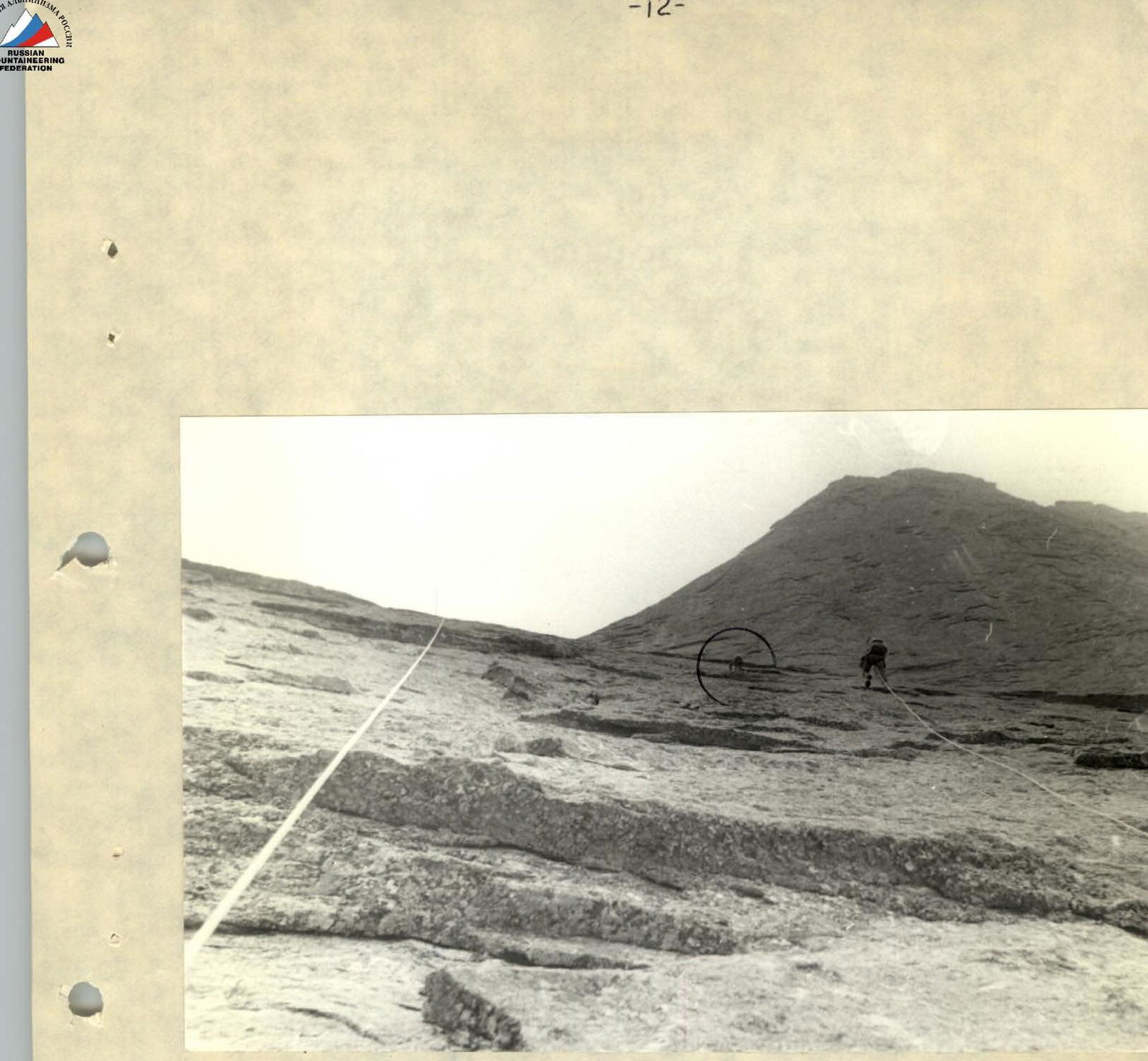
Photo 6. Passage of section R2–R3 on the peripherals. Camera "Smena-Simvol". February 13, 1990.