PASSPORT
- Class — technical
- Pamir-Alay, Turkestan Range, Kara-su gorge
- p.4810(c) via the buttress 10.3. of the wall
- Proposed — 5B category of difficulty
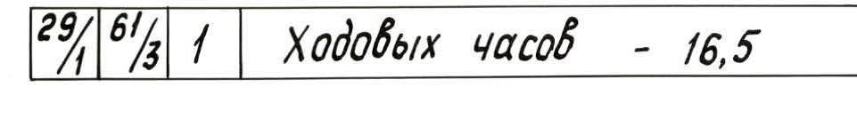
- Height difference 700 m, length 910 m Length of sections of 5–6 category of difficulty — 390 m Average steepness of the main part of the route — 70°
- Pitons hammered in: rock — 29, bolt — 4, chocks — 63
- Team's travel hours — 16.5; days — 2
- Overnight stays on the route — 3 bivouacs (1st — below the route, 2nd — on the route; 3rd — on descent)
- Leader: Nazarov Oleg Vasil'evich MS Participants: Zinchenko Mikhail Nikolaevich CMS, Usevich Dmitriy Antonovich CMS, Belovtov Yuriy Valentinovich CMS
- Team coach — Solonnikov Viktor Aleksandrovich
- Approach to the route July 8, 1988 (July 7, 1988 — approach to the route) Summit July 9, 1988, return July 10, 1988
- Organization — LOS DFCO Trade Unions Leningrad
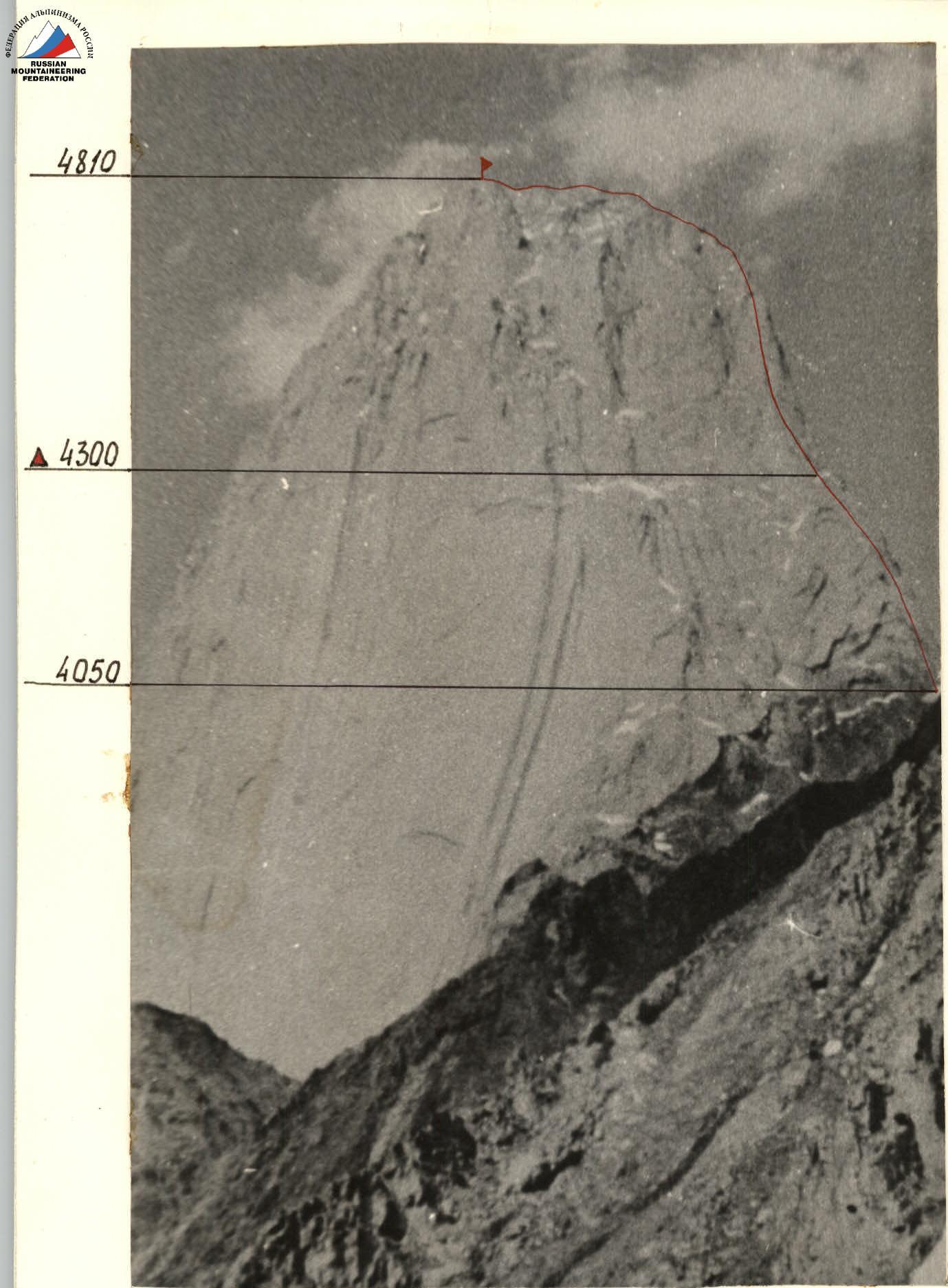
p.4810 m. Route via the buttress 10.3. of the wall. Photo #1. Taken on June 20, 1988. Lens T-43, F.R. 4 cm. Shooting point #1. Height — 3400 m.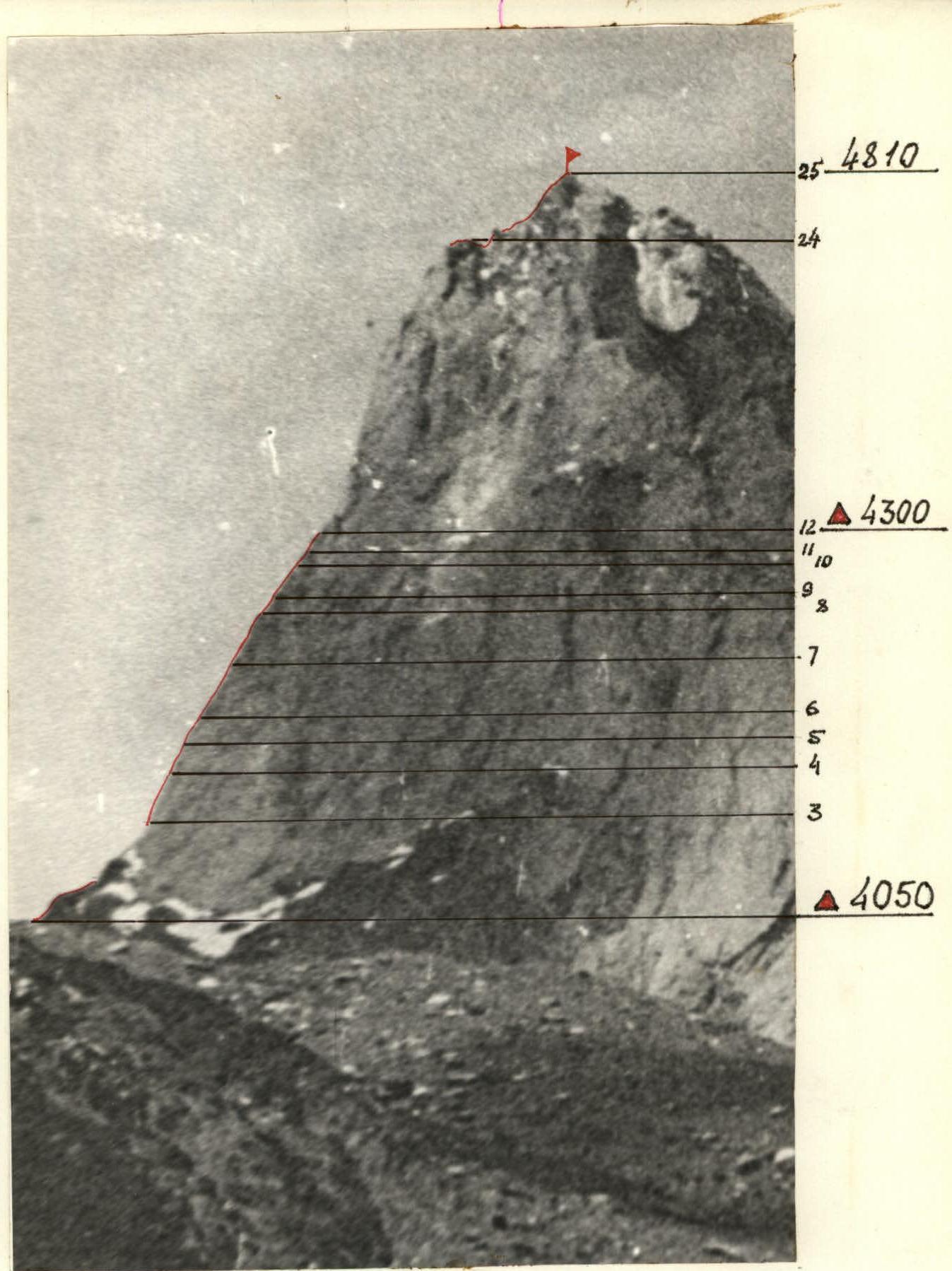
Photo #2. Route profile on the right. Overnight stays and their heights. Taken on June 21, 1988. Lens T-43, F.R. 4 cm. Distance 3.5 km. Shooting point #2. Height — 3600 m.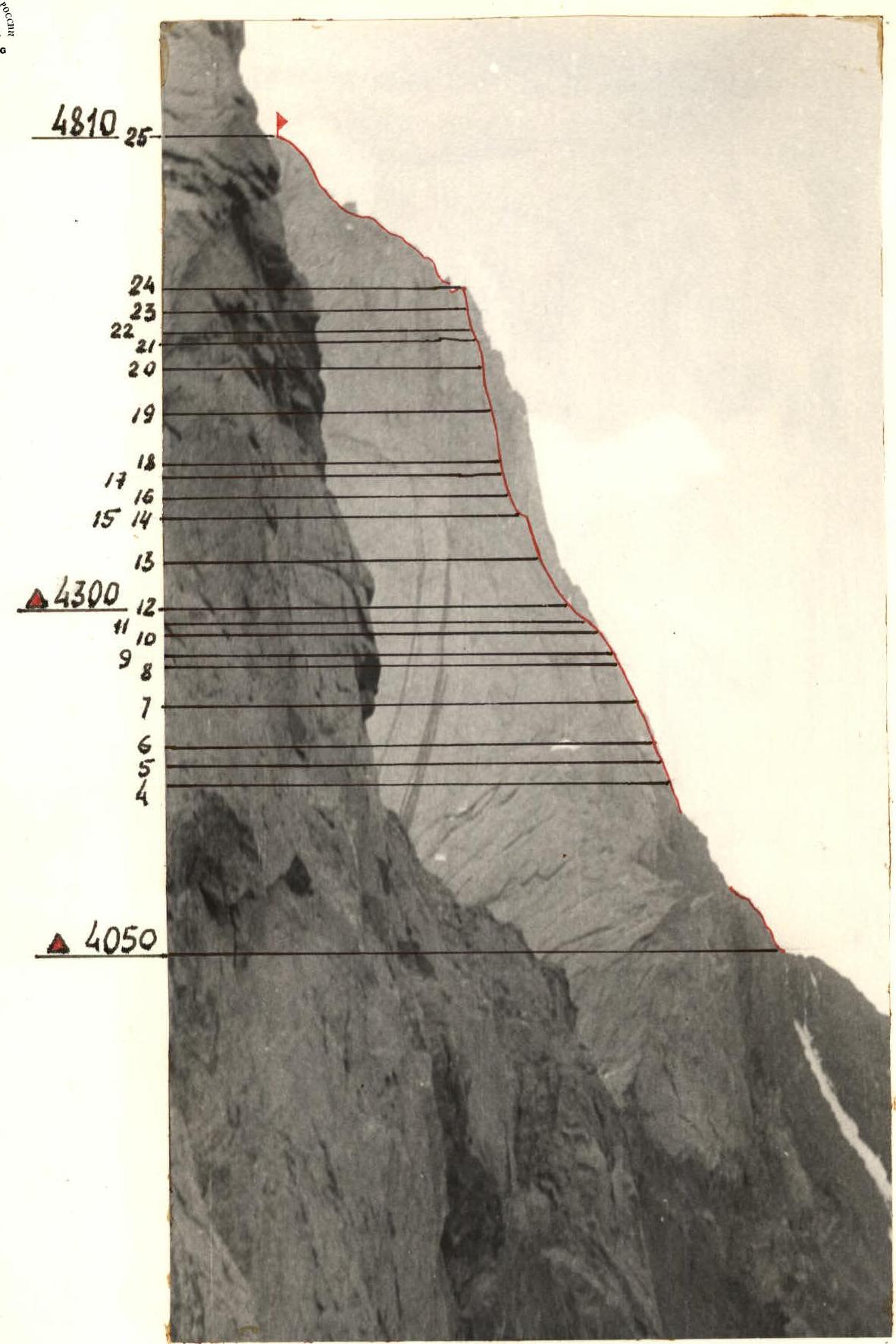
Photo #3. Route profile on the left. Overnight stays and their heights. Taken on July 3, 1988. Lens T-43, F.R. 4 cm. Distance 1.5 km. Shooting point #3. Height — 3600 m.
Tactical Actions of the Team
The team's tactical plan during the ascent included: reaching the pass between p.4810 and 4925, then moving along simple rocks of the buttress to the main part of the route. Overcoming a giant triangular cornice in its lower right part and exiting onto monolithic slabs and faces of the buttress, then bypassing several cornices under the bastion of the buttress. The bastion is overcome from the left along an internal corner, along its right monolithic part, and further to the pre-summit ridge.
Observations established that the main rockfall collectors and paths are located at a significant distance from the route, and the route's rockfall danger is low. This allows the team to work throughout the daylight hours. Since the probability of organizing good overnight stays on the main part of the buttress is low, it was decided to limit the team composition to four athletes.
Based on the estimated length of the route, the following breakdown of the route's passage by days was adopted:
- 1st day — reaching the pass under the start of the buttress p.4810;
- 2nd day — reaching the second overnight stay under the rock bastion of the buttress;
- 3rd day — overcoming the rock bastion, exiting onto the pre-summit ridge;
- 4th day — reaching the summit and descending;
- 5th day — descending to the base camp.
The team's tactical actions were determined by the tactical plan, which was largely executed. Deviations from the tactical plan: the bastion and pre-summit ridge were passed a day earlier.
The determining factor in the team's speed was the time taken to pass sections as the first. The entire group, including the last, managed to catch up and receive necessary equipment. The first worked without a backpack and in galoshes. The route was mostly climbed using free climbing. The leaders changed daily, but during the day, there was no change.
- On the 1st day, the rope team Zinchenko — Nazarov worked;
- On the 2nd day — Usevich — Belovtov.
On sections of 4 and 5 category of difficulty, except for the first, the entire team moved along a fixed rope. Sections R12–R15 were preliminarily processed.
Overnight stays on the route were bivouacs on ledges. The safety of the ascent was ensured by the use of imported ropes with good dynamic characteristics and textile shock absorbers for the first's work. A diverse set of pitons and chocks allowed for reliable belays and fixed ropes, and also gave the possibility, if necessary, to rappel down any part of the route.
There were no falls or injuries during the passage of the route. No принципиально new samples of equipment were used on the ascent (if not counting already established practices like "friends", крюконоги, etc.).
The weather was good throughout the ascent days, with snow falling only on the evening of July 7 and the night of July 8, when the team was at an overnight stay on the pass under the route. Regular and stable communication was maintained with the base camp using the "Lastochka" VHF radio station.
Route Diagram in Symbols
M 1:200
1 mm = 2 m in height
Taverses (traverses) are not to scale.
| Rock Pitons | Chocks | Bolt Pitons | Photo Number | Difficulty | Section Length | Steepness (degrees) | Section Number |
|---|---|---|---|---|---|---|---|
| For the day travel hours — 8.5 | |||||||
| 7 | 34/2 | 1 | 5 | 6 | 7 | R12 | |
| 1 | 1 | 2 | 5 | 15 | 60 | R11 | |
| 5 | 10 | 70 | R10 | ||||
| 5 | 25 | 60 | R9 | ||||
| 8 | 60 | 8 | |||||
| 1 | 3 | 5 | 35 | 60 | R7 | ||
| 1 | 5 | 5 | 45 | 70 | R6 | ||
| 2 | 2 | 4 | 20 | 65 | R5 | ||
| 3 | 5 | 25 | 70 | R4 | |||
| 2 | 5 | 35 | 70 | R3 | |||
| 7/1 | 5 | 25 | 70 | R2 | |||
| 4/1 | 1 | 1 | 6 | 20 | 82 | R1 | |
| 80 | 40 | R0 | |||||
| Travel hours — 6 | |||||||
| 22/4 | 27/4 | 4 | 20 | 70 | R24 | ||
| 3 | 4 | 20 | 60 | R23 | |||
| 1 | 3 | 5 | 15 | 60 | R22 | ||
| 1 | 2 | 5 | 20 | 65 | R21 | ||
| 3 | 2 | 5 | 45 | 70 | R20 | ||
| 3 | 4 | 5 | 5 | 45 | 80 | R19 | |
| 5/1 | 2/1 | 4 | 4 | 20 | 70 | R18 | |
| 3 | 5 | 15 | 70 | R17 | |||
| 2 | 2 | 5 | 25 | 80 | R16 | ||
| 4 | 2 | 5 | 35 | 70 | R14–R15 | ||
| 3 | 4 | 40 | 70 | R13 | |||
| 4 | 3 | R12 |
Total on the buttress
 Rock pitons: 29/1, chocks: 61/3, bolt pitons: 1. Travel hours — 14.5.
The route diagram above the buttress is not provided. Average steepness of the ridge ≈ 40°; 3 category of difficulty, length — 290 m.
From the top of the buttress to the summit: travel hours — 2.
Total on the route
 Rock pitons: 29/1, chocks: 61/3, bolt pitons: 1. Travel hours — 16.5.
Route Description by Sections
R0–R1. Destroyed rocks 2 category of difficulty.
R1–R2. Steep wall. Rime ice. Vertical smooth slots. Blind cracks. Use of ITO, skyhook, chocks, bolt piton.
R2–R3. Monolithic wall without cracks. Internal corner. Free climbing. Use of ITO.
R3–R4. Steep slab with small ledges and a slot. Very difficult free climbing. Chocks.
R4–R5. Vertical narrow slot. Bypassing a cornice on the right. Chocks.
R5–R6. Slot. Movement to the right.
R6–R7. Bypassing a cornice on the left along a monolithic slab. Difficult climbing. Chocks.
R7–R8. Careful movement to the right along a slot. Rime ice. Chocks.
R8–R9. Internal corner. Free climbing.
R9–R10. Wet smooth slab. Free climbing. Chocks.
R10–R11. Oblique, wet, inclined ledge. Movement to the left to an internal corner.
R11–R12. Internal corner. Rime ice. Exit onto a ledge. Overnight stay on the ledge. Snow on the ledge.
R12–R13. Wall of large rock fragments with slots. Free climbing. Chocks.
R13–R14. Vertical internal corner. Monolithic slab on the side. Exit onto a narrow ledge. Free climbing.
R14–R15. Narrow horizontal ledge 10 m. Traverse to the left. Careful free climbing.
R15–R16. Steep internal corner. Rime ice. Very difficult climbing.
R16–R17. Steep wall with small ledges. Free climbing.
R17–R18. Wide internal corner.
R18–R19. Overhanging internal corner, overlapped by a cornice. Strenuous climbing in opposition, hanging. Slots for chocks. ITO.
R19–R20. Steep monolithic slab, slot for chocks. Wet lichen on the slab. Careful complex climbing.
R20–R21. Along a slot, bypassing an overhanging cornice. Along an inclined ledge like a " катушка" there are no slots for chocks and pitons. Exit to the wall. Pendulum to the left into an internal corner.
R21–R22. Vertical slab. Free climbing.
R22–R23. Oblique inclined ledge, cracks for chocks. Movement to the left.
R23–R24. Vertical wall. Exit onto the ridge.
R24–R25. Ridge. Rock walls, slabs, and internal corners 3 category of difficulty.
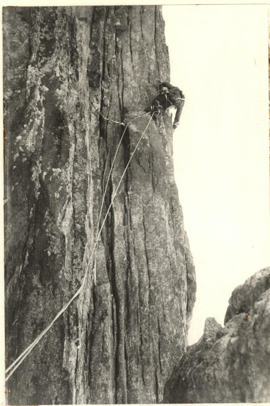 Photo #1. Section R1–R2. July 8. Shot from the start of the section.