- Technical category.
- Pamir-Alay, Turkestan Ridge, Karavshin river basin.
- Peak 4507 (1000th anniversary of the Baptism of Russia) via the SE wall.
- 6B category of difficulty, rock climbing, 3rd ascent.
- Height difference: total in the wall section
| 880 m | 640 m | |
|---|---|---|
| length | 1058 m | 688 m |
| avg. slope | 67° | 75° |
| length of sections | V category of difficulty | 210 m |
| VI category of difficulty | 458 m |
- Pitons hammered in:
| rock | placements | stoppers | ice |
|---|---|---|---|
| 14 | 162 | 0 | 0 |
| 0 | 8 | 0 | 0 |
-
Climbing hours 18+ (5 hours descent) days 3.
-
Overnights: all overnights are comfortable, in a tent.
-
Leader: Kotelnikov A.I. — Master of Sports
Participants: An P.V. — Master of Sports
| Bukreev V.V. | — Master of Sports |
|---|---|
| Zaikin A.A. | — Candidate for Master of Sports |
| Kolabushkin V.A. | — Candidate for Master of Sports |
| Selyaev V.V. | — Master of Sports |
Coaches: Shabanov A.V., Kudakaev T.Z.
10. Approach to the route 12.07.92, summit 14.07.92, descent 14.07.92.
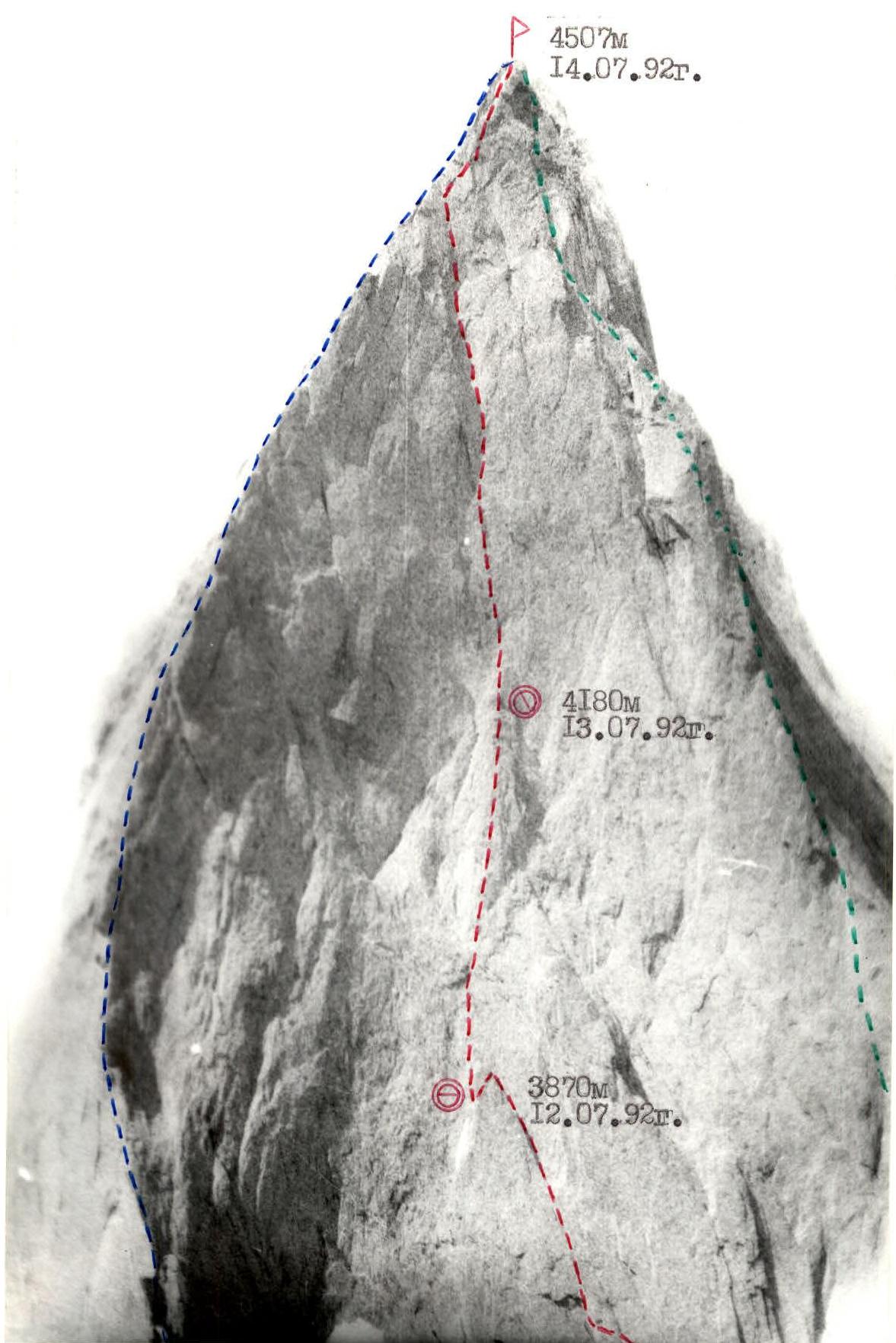
GENERAL PHOTO OF THE SUMMIT Taken on 17.07.92 at 11:00. Camera "Lomo-Compact". Distance – 3 km.
Conventions:
- Route of Moscow sports club, 1989 group
- Route of "Height" sports club, 1991
- Route of Dnipropetrovsk group, 1988
ROUTE SCHEME IN UIAA SYMBOLS
| I | 2 | 3 | 4 | 5 | 6 | 7 | 8 | 9 |
|---|---|---|---|---|---|---|---|---|
| - | 2 | - | - | 26 | 2 | 100 | 20 | |
| - | 2 | - | - | 25 | IV | 40 | 40 | |
| - | 10 | - | - | 24 | VI | 60 | 70 | |
| - | 4 | - | - | 23 | VI+ | 10 | 90 | |
| - | 6 | - | - | 22 | VI+ | 10 | 90 | |
| - | 3 | - | - | 21 | VI | 10 | 75 | |
| - | 8 | - | - | 20 | VI | 10 | 75 | |
| 2 | 9 | - | - | 19 | VI+ | 40 | 80 | |
| I | 6 | - | - | 18 | VI+ | 10 | 95 | |
| 2 | 1/2 | - | - | A3 | VI+ | 40 | 85 | |
| 3 | 1/3 | - | - | A3 | VI+ | 60 | 85 | |
| - | 6 | - | - | 4200 m | 13.07.92. rock pitons –5, placements –48 | IV | 40 | 50 |
| I | 1/1 | - | - | A2 | VI | 60 | ||
| I | 1/2 | - | - | VI+ | 40 | |||
| 2 | 6 | - | - | V | 40 | |||
| I | 4 | - | - | V | 80 | |||
| 7 | 2 | 3 | 4 | 5 | 6 | 7 | 8 | 9 |
| :-: | :---: | :-: | :-: | :----------: | :----------: | :-: | :-: | :-: |
| rock pitons –8, placements –82. | 14.07.92. 4507 m | |||||||
| - | 2 | - | - | 27 | III | 40 | ||
| - | 2 | - | - | 26 | II | 100 |
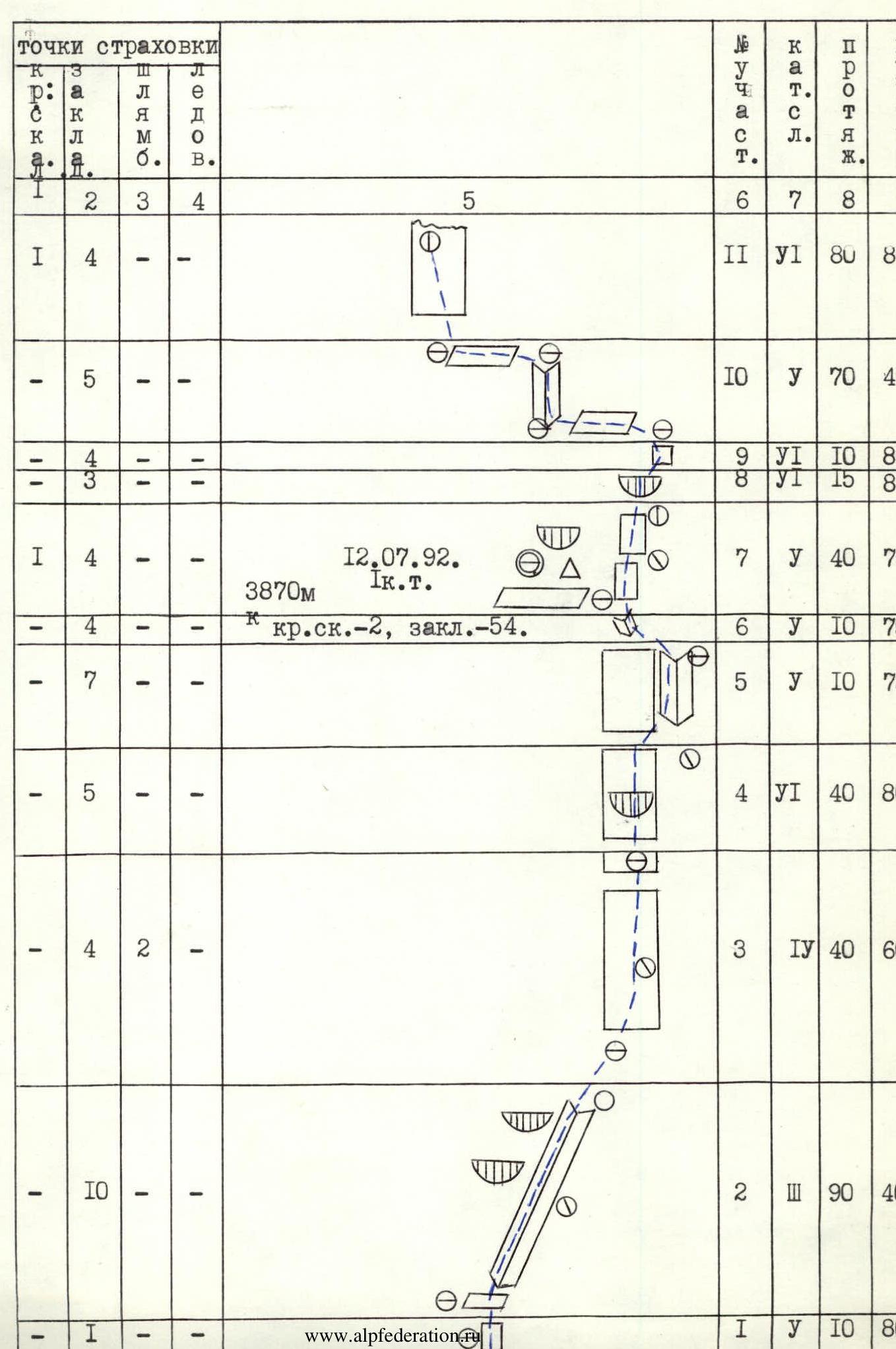
Route description by sections
R0–R1. Crack in a monolithic wall leading to a good ledge. R1–R2. Inner corner going up to the right from the ledge. There is always a stream (first climber works in water). R2–R3. Rocks resembling "sheep's foreheads" leading to the base of a sheer wall with black streaks. R3–R4. Moderately difficult rocks to the right of the wall with black streaks. R4–R5. Very difficult inner corner of S-shape with an overhang in the middle part. The corner is formed by the wall and a sheer ledge. Medium and small-sized placements are used. The section is climbed free. R5–R6. Difficult 3-meter traverse along small overhangs. R6–R7. System of inner corners going up to the left. At the end of the section, there is a good ledge going left. Water is present. On the ledge, there is a bivouac under an overhang, and a control cairn. R7–R8. Climb up to the right along the corner of the ledge. Two rock walls lead to the base of an overhanging flake. R8–R9. Inner corner-crack going up to the right, bypassing the flake. R9–R10. Straight up along the overhanging flake. Then traverse left along the ledge for 20 m to an inner corner. R10–R11. Inner corner with an upper part going up to the left. The section ends with a simple 20-meter traverse left. R11–R12. Very difficult, wet wall with few places for intermediate protection. Climb up to the left to a ledge. The section ends with a simple 8-meter traverse left. R12–R13. Wide inner corner leading to a rock shoulder of a large flake on the wall. Bivouac, no water. R13–R14. Difficult wall with limited intermediate protection. R14–R15. Very difficult wall. Climbed via a system of flakes and cracks. Many loose, unreliable rock formations. R15–R16. Inner corner leading to the summit of a wall spall. Under the cover of the spall, there is a bivouac on a ledge. No water, but there may be ice in a rock depression of the inner corner to the left of the ledge. R16–R17. Extremely difficult wall. Climb up to the left, then up to the right under a characteristic triangular cornice. AIT (Artificial Insulation Technique). Under the cornice, there is a control cairn. R17–R18. Extremely difficult crack to the right of the cornice. The crack is 2 to 20 cm wide. Friends and large placements are used. R18–R19. Extremely difficult overhanging inner corner with a crack. In this place, climb using AIT up a small crack to the left onto an overhang (3 m). Then, pendulum right to the narrowing of the crack. R19–R20. Extremely difficult, wet crack formed by the wall and a flake (crack width from 1 to 20 cm). The left side of the crack overhangs. Climbed with AIT. R20–R21. Inner corner going sharply left, climbed free with wide stemming. R21–R22. Very difficult wall of a spall. Climbed free. R22–R23. Extremely difficult crack with an overhang. Climbed with AIT. R23–R24. Extremely difficult wall of a rock block. Climbed up to the left. At the end of the section, there is a comfortable platform. R24–R25. Very difficult inner corner leading to the left edge of the SE wall. R25–R26. Sharp ridge leading to the summit ridge. There is a characteristic grotto. R26–R27. Knife-like ridge. R27–R28. Crack and inclined slab on the right part of the summit tower.
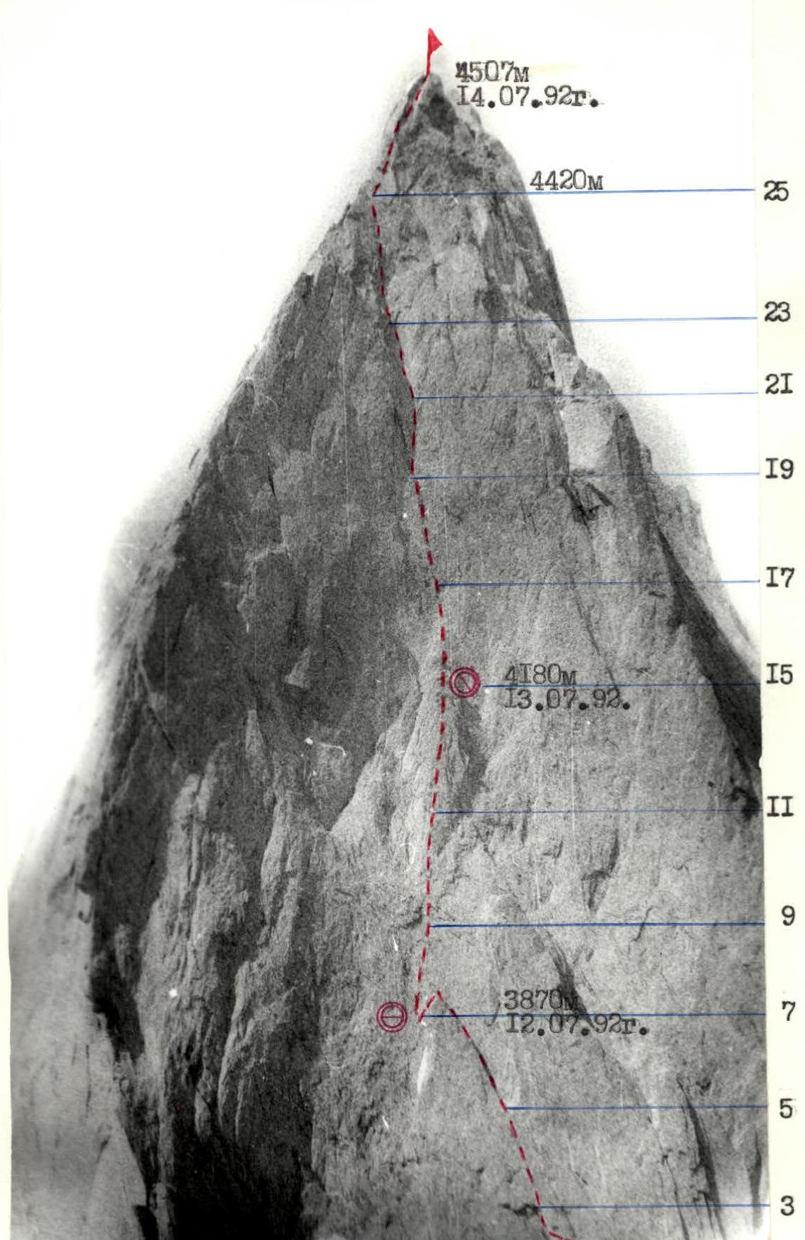
TECHNICAL PHOTOGRAPH OF THE ROUTE. Taken on July 17, 1992, at 11:00. Camera "Lomo-Compact". Distance – 3 km.