Passport
-
Technical category.
-
Northern spurs of the Turkestan Range, Kara-Su gorge.
-
Peak 4520 m via the Southeast wall.
-
Proposed 5B category of difficulty, first ascent.
-
Height difference 550 m, length.
Length of sections:
- 6th category of difficulty — 110 m
- 5B category of difficulty — 260 m
Average steepness of the route — 58°. Average steepness of the wall section — 75° (at 3900–4100 m wall section).
-
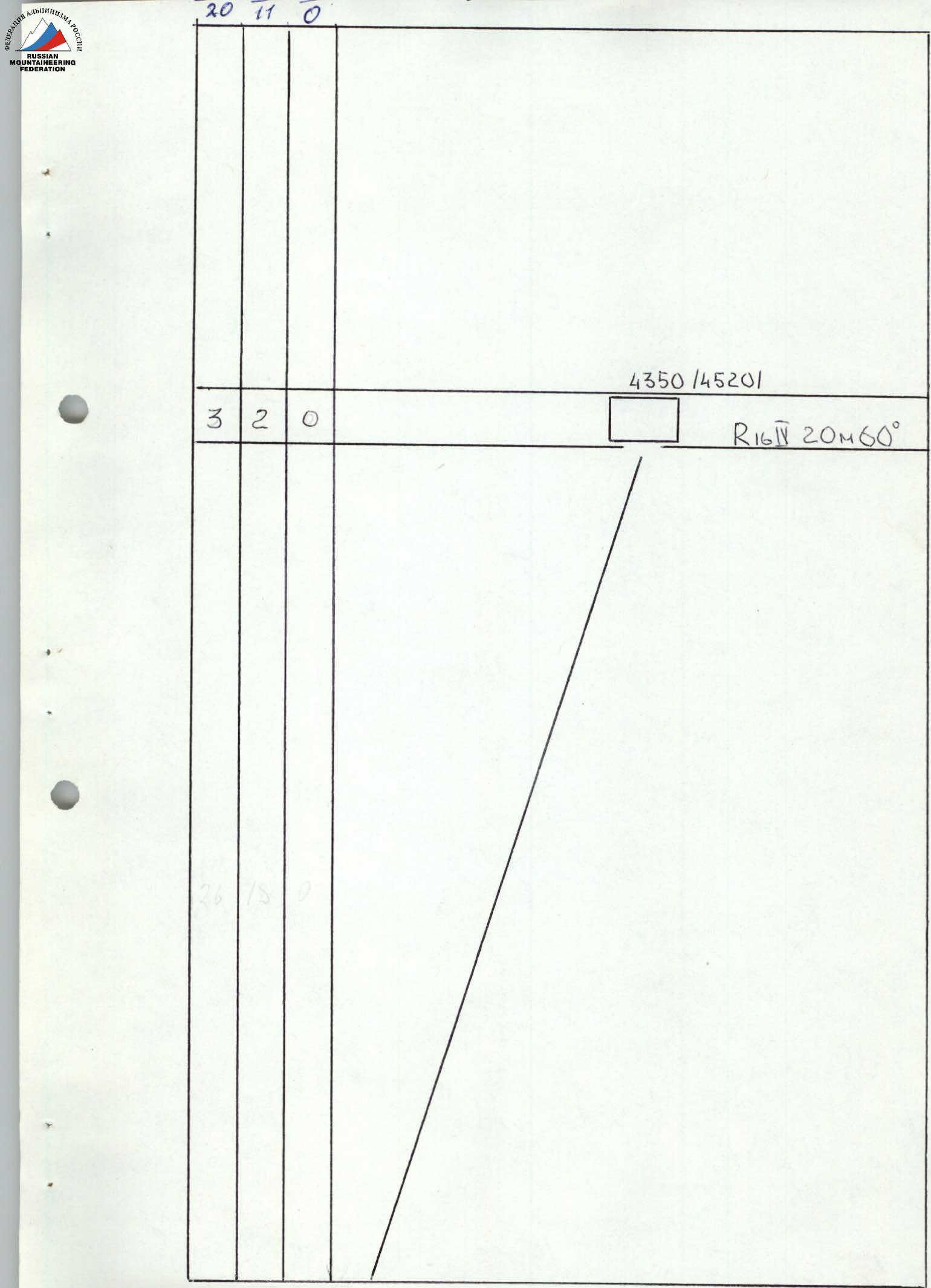
Pitons driven:
- Rock: 132/20
- Chocks: 70/11
- Bolted: 0/0
- Ice: 0/0
-
Number of climbing hours: 18 days 2 hours.
-
Overnight stays:
-
Leader: Pyotr V. Kozachok, Master of Sports in mountaineering.
Participants:
- V. A. Savenko, Candidate Master of Sports
- V. I. Tochinskiy, Candidate Master of Sports
- A. N. Popov, Candidate Master of Sports
- B. P. Pokhil, Candidate Master of Sports
-
Coach: Vladimir N. Timofeev, Master of Sports.
-
Departure on the route: July 8, 1988.
Summit: July 9 Return: July 10, 1988.
-
Dnepropetrovsk Sports Committee. 1350 (4520)
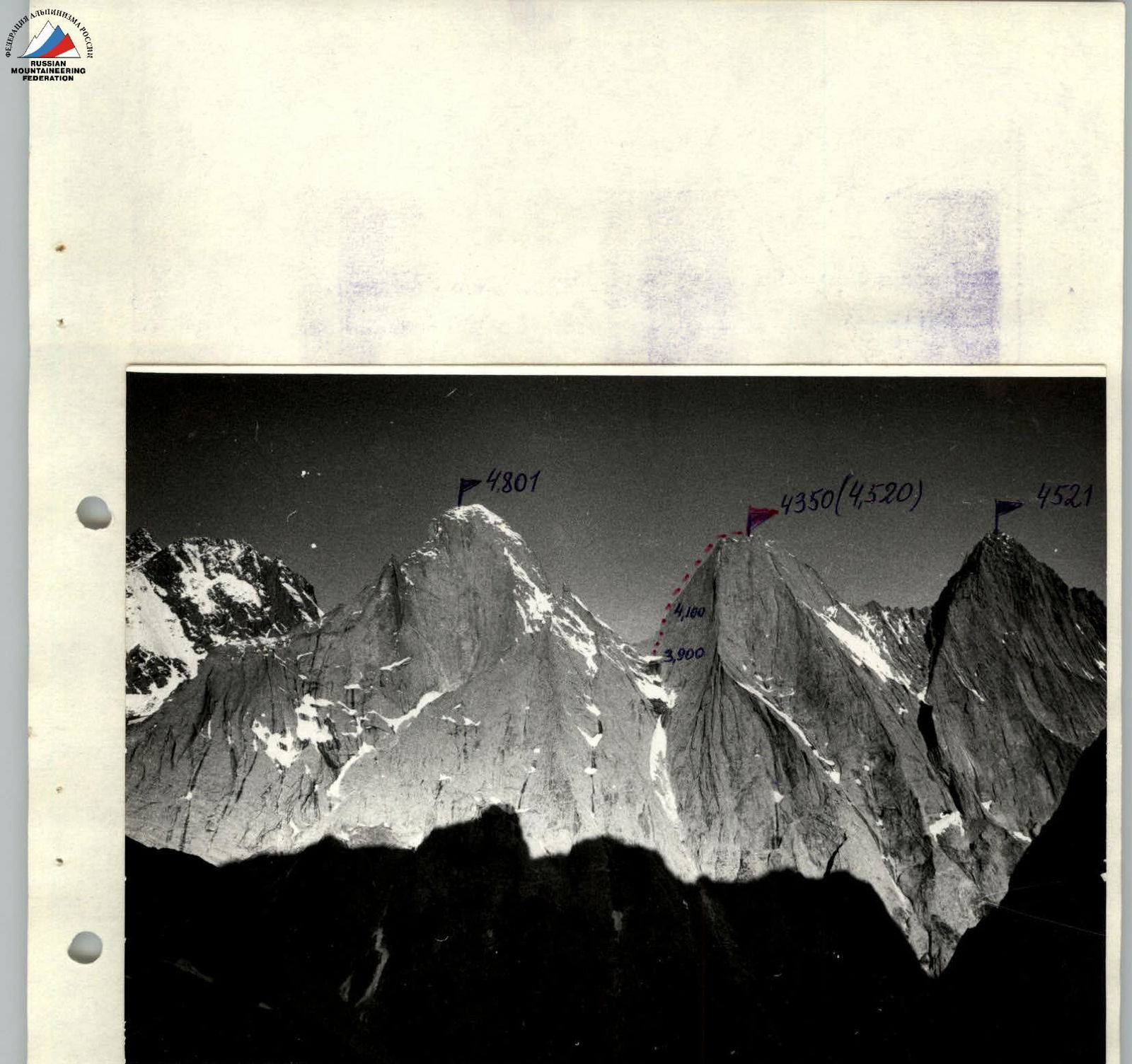
Photopanorama of the area. Lens type: Industar. Shooting point: BC, its height 3500 m. Date of shooting: July 9, 1988. Distance to the object: 2000 m, F=50 mm.
The tactical plan provided for the route to be completed in three days with preliminary processing.
- Day 1 — approach to the route, organization of a bivouac and processing of the wall.
- Day 2 — start on the route, work up to point R8.
- Day 3 — start working on the route from R8 to R14.
- Day 4 — further passage of the route and exit to the summit. Start of descent.
Note: in case of bad weather, the group plans for one reserve day.
The team's departure on the route was one day late due to bad weather (snow, rain).
The route was completed in one day. The breakdown of the teams and the change of leading teams during the day were as follows:
- Day 1 — processing: A. N. Popov, B. Pokhil, Tochinskiy — 100 m.
- Day 2 — P. V. Kozachok, V. Savenko — team R15. Change of teams: V. Tochinskiy, A. Popov, B. Pokhil — team #2, working on R15–R16.
Thus, each team worked first during the day. The first team worked on a double rope. At the insurance points, all pitons were blocked with a separate loop, which eliminated "rupture" and increased the working length of the rope by 2–3 m. Throughout the route, fixed ropes were left. The second member of the first team, while moving, straightened the fixed ropes and made points for their intermediate insurance. The second team followed the fixed ropes, additionally insured by a team rope, passing it through intermediate carabiners.
The work and rest regime is presented in detail on the ascent time graph. Time working on the wall — no more than 13 hours a day.
Safety measures:
- leading climber working on a double rope, one of which is UIAA;
- insurance through an "8" descender;
- blocking of all pitons at insurance stations;
- use of extenders with shock absorbers when moving on fixed ropes with a jumar and a prusik knot.
All non-standard equipment was tested on the Ullu-Tau test site.
During bad weather on July 7, 1988, the group was in a tent under the route. There were no accidents or injuries.
In solving the problem of overcoming complex sections, the team fully utilized:
- their experience,
- technical qualification,
- physical preparation,
which made it possible to overcome the route at a good pace and with a sufficient margin of reliability.
Communication with observers was via a 70 RPG-24M radio station. A rescue team and observers were located below, along with a gathering of climbers from Kharkov.
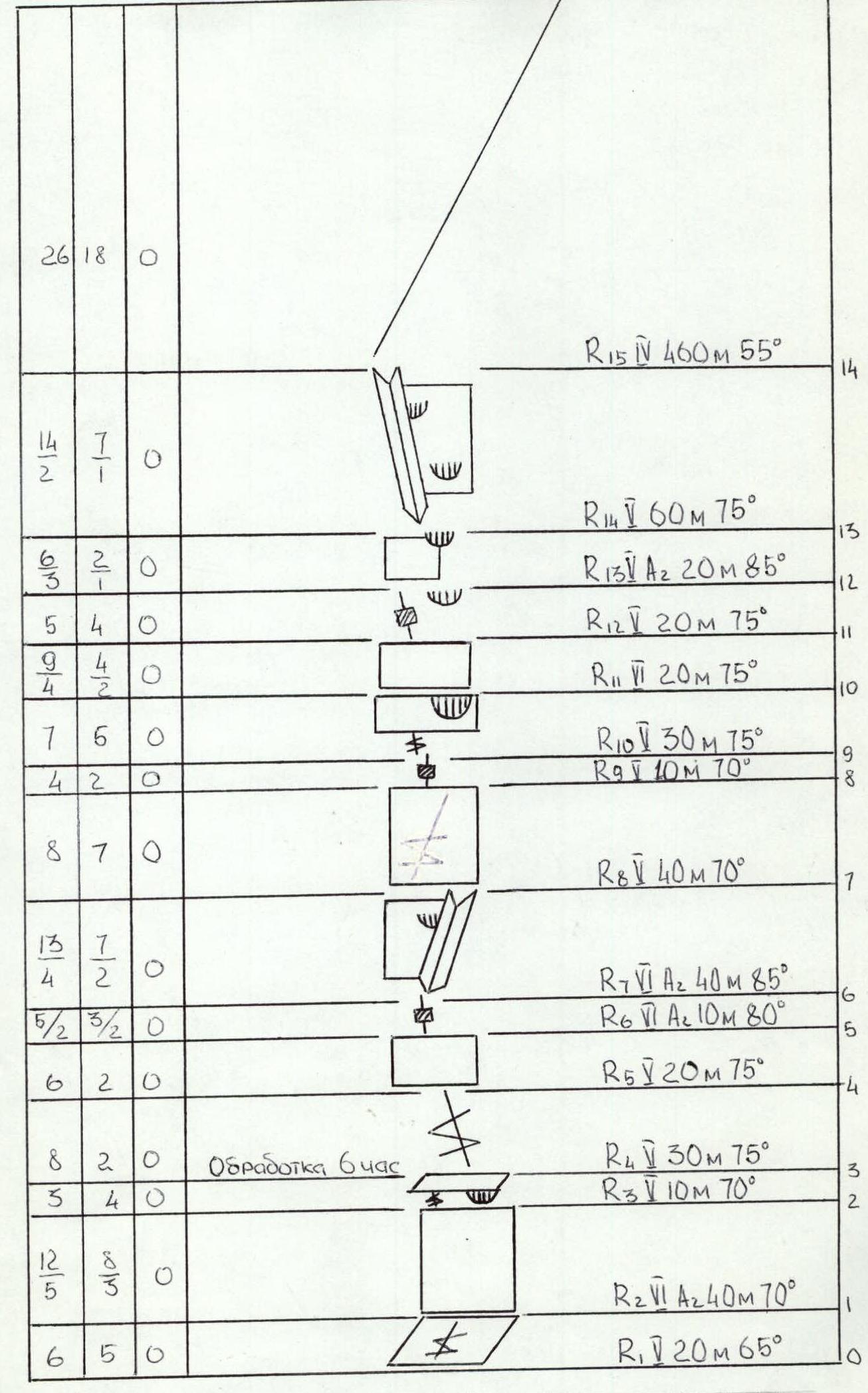
Fig. No. Route scheme in symbols. M1:2000
Description of the route by sections
The team left the base camp in the Ak-Su gorge at 14:00 on July 7, 1988.
Approach to the start of the route: from the Ak-Su gorge, pass through a large green meadow and a saddle into the Kara-Su gorge (1 hour 20 minutes).
Further:
- Along the path up the talus cone, leaving the Asan-Usan peak to the right.
- Straight ahead, the 4801 m peak is visible, to the left of it is a snow-ice couloir that borders on peak 4520 m.
- 250 m up the couloir, then left along the wall (4 ropes, 4th category of difficulty) lead to a saddle, which resembles a sharp ridge with a small (3 m) dip.
- Further along a ledge, traverse down to the left 100 m to the start of the route.
The approach from the base camp takes 5–6 hours.
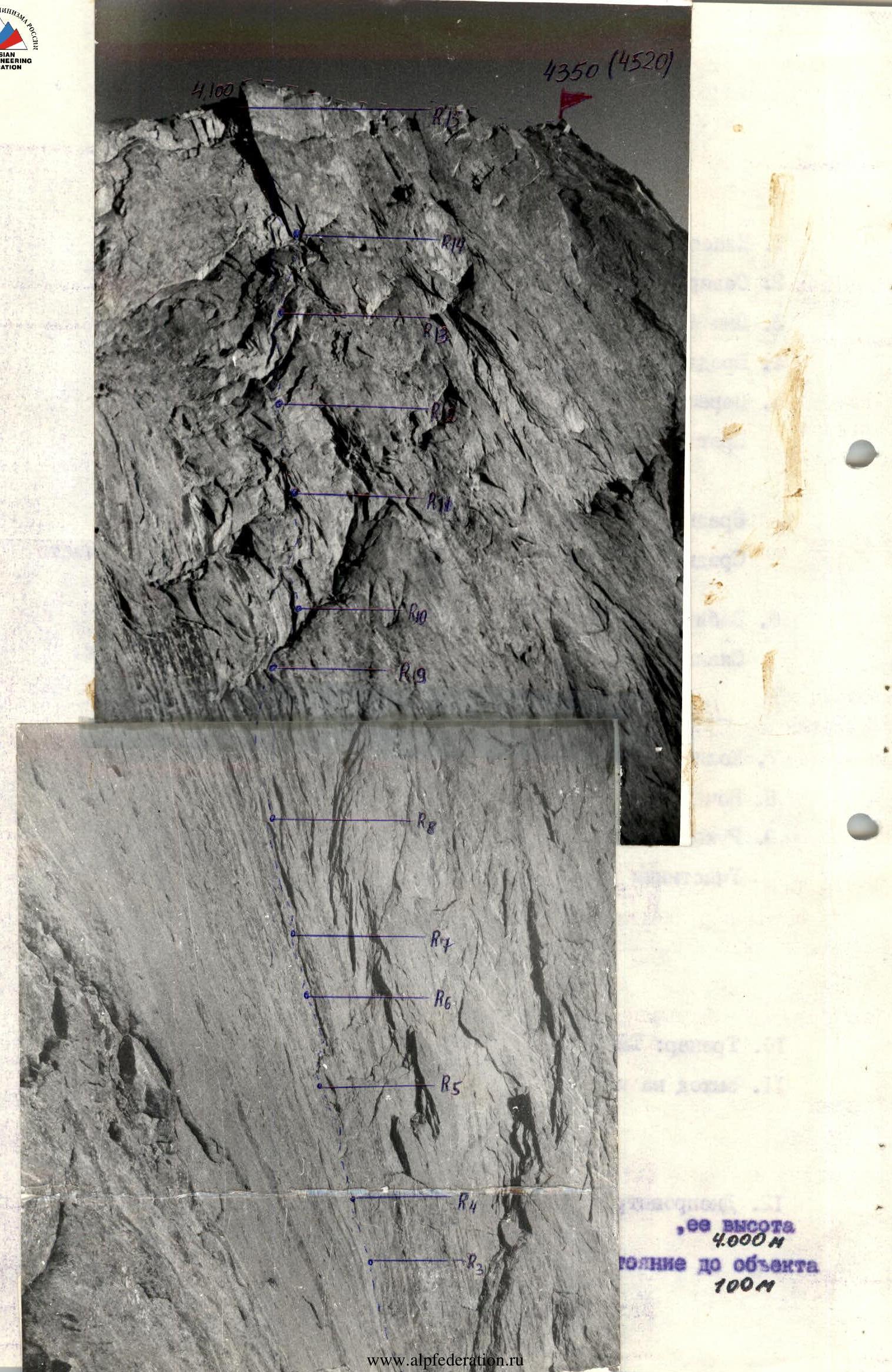
Day 1: processing of the route R1–R3 (70 m). Team #2 worked. Day 2: R4 — along small cracks with difficult climbing and minimal relief, we approach under the slab — team #1 works.
R5 — slab turning into a crack. R6 — continuation of the crack with very difficult climbing. R7 — internal angle, extremely complex climbing, worn holds, "live" rocks present.
R8 — smooth wall with small overhanging sections.
R9 — crack passed on aid climbing using pitons and chocks.
R10 — wall, in the right part of which there is a cornice with many side holds.
R11 — very steep wall, in places aided climbing, very complex balance climbing.
R12 — starts with a crack, ends with a cornice, which is bypassed on the left.
R13 — wall with an overhanging cornice, which is passed on aid climbing, "live" rocks present.
R14 — internal angle with two small cornices, climbing is extremely complex, limited number of holds. Further, an internal angle leads to the ridge.
R15 — ridge 4–5 category of difficulty, 460 m. Many cracks, small walls, very clean relief, places for overnight stays. Change of teams.
R16 — wall 20 m, leading to the summit. Descent along the SE ridge to the start of rappels.