PASSPORT
- Rock class
- Pamir-Alay, Turkestan Ridge, Kara-Su gorge
- Peak Asan 4230 m, via the right part of the northwest wall
- Proposed 6th category of difficulty, 2nd ascent
- Height difference — 960 m, length — 1445 m Length of sections with 5–6 category of difficulty — 700 m Average steepness of the main part of the route — 74° (3420–4050 m) Including 6th category: 80° (3460–3500, 3520–3610, 3710–3760, 3890–3960), 85° (3640–3710), 95° (3960–3965), 100° (3610–3620)
- Pitons driven: Rock — 8 Bolts — 33 Nuts — 238 Skyhooks — 29, 16, 55
- Climbing hours — 29, days — 3
- Overnights: first on a ledge, lying; second on small ledges, lying one by one
- Leader: Anatoly Ivanovich Moshnikov (MS) Participants: Alexey Georgievich Kritsuk (MS) Vladimir Olegovich Kaurov (CMS) Viktor Semenovich Pleskachevsky (CMS) Valery Anatolyevich Ivanov (CMS)
- Coach: Yuri Iosifovich Beilin (MS)
- Route start: June 27, 1988 Summit: June 29, 1988 Return: June 29, 1988
- Organization: LenGorsportkomitet
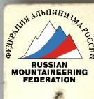
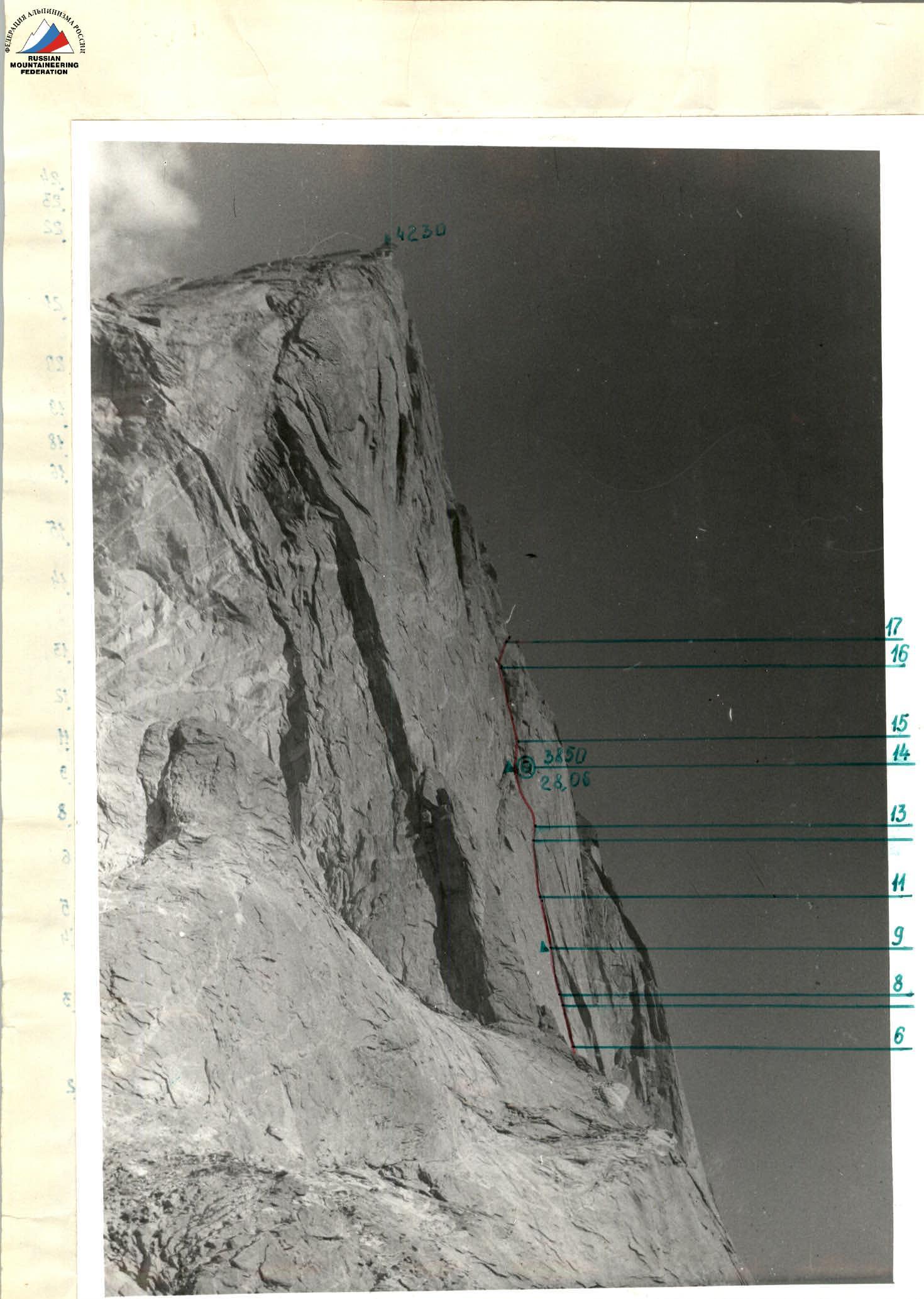
General photo of the summit
Taken from the moraine of the glacier on June 31, 1988. №1. Lens "Helios 44-2" F-58 mm. Distance 1.5–2 km, height — 3400 m.
Route of team A/K "Nevsky" Route of Alperin V. 1987
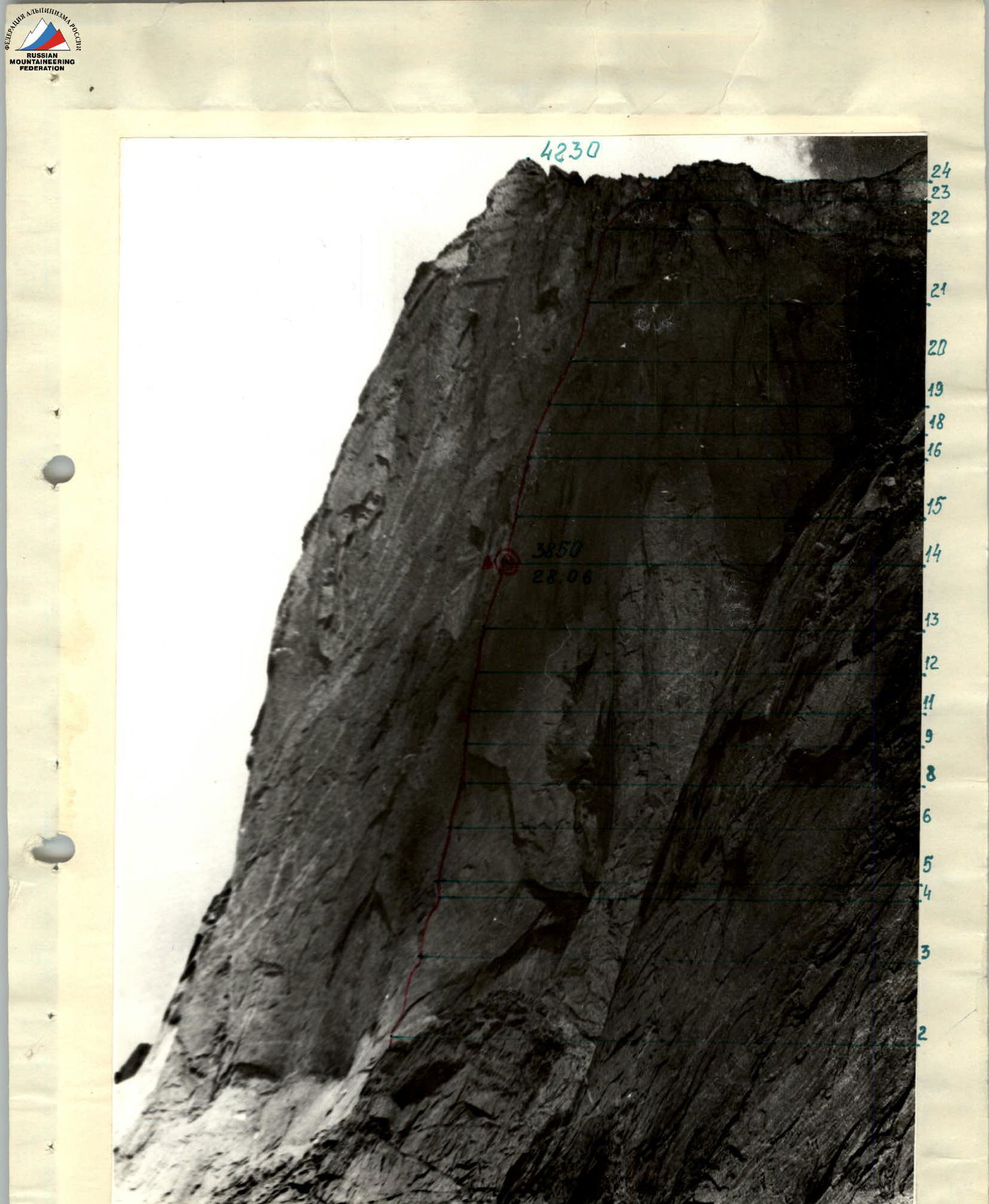
Profile of the wall from the right
Taken from the moraine of the glacier on June 31, 1988. №2. Lens "Helios 44-2" F-58 mm. Distance 1.5 km. Height — 3500 m.
Profile of the wall from the left
Taken from the moraine of the glacier on June 31, 1988. №3. Lens "Helios 44-2" F-58 mm. Distance 1.5–2 km. Height — 3000 m. Route of the team.
Tactical actions of the team
| | 2 | | | R12 5 m A2 95° | 10 | 7, 10 |
| | 10/3 | | | | | R11 30 m VI 85° | 9 | 7, 10 |
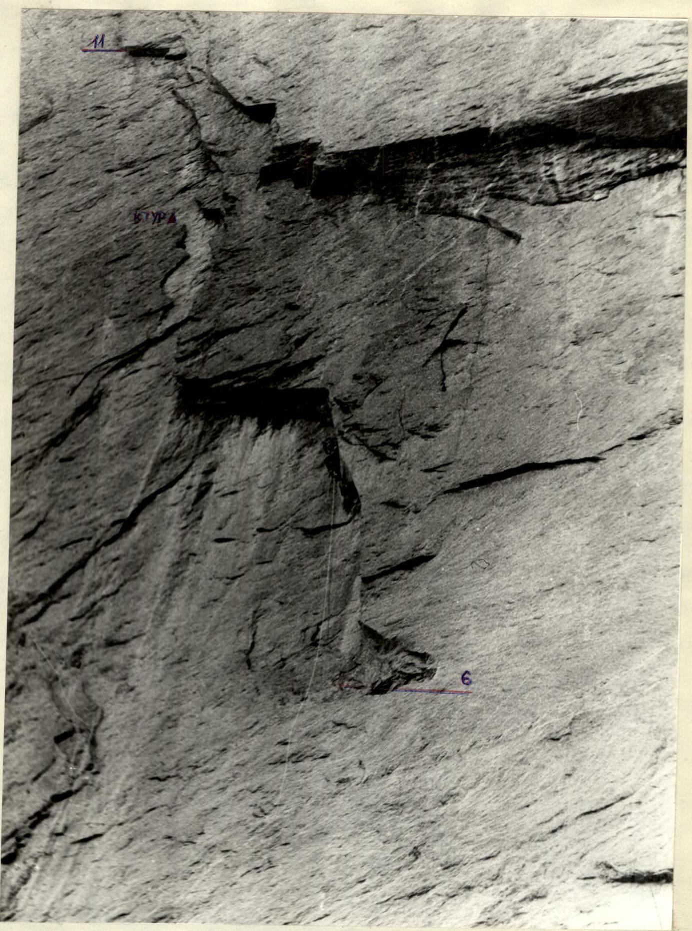
| | 15/6 | 1 | | К.Т.У. 3670 m | | R10 40 m VI 85° | 8 | 11, 7, 9, 10 |
| 1 | 4/4 | | 3 | June 27, 1988 11:40 | | R9 10 m A4 100° | 7 | 11, 7, 9, 10 |
| 1 | 20/10 | 3, 1 | 6 |  | | R8 40 m VI 80° R7 15 m VI 80° | 6 | 10, 11, 7, 8, 9 |
| 2 | 10/4 | 3, 3 | 2 | | | R6 50 m VI 80° | 5 | 7, 8, 9 |
| | 4 | 3 | 1 | | | R5 30 m V 60° | 4 | 6, 7 |
| | | 13 10 | 13 | | | R4 40 m A2 80° | 3 | 6, 7 |
| | 2 | 8 | 4 | | | R3 50 m V+ 60° | 2 | 6 |
| 3 | 15 | | | | June 27, 1988 3350 m | R2 100 m IV 45° | 1 | 5, 6 |
| | | | | | | R1 300 m I–II 15° | | |
| | | | | | | M 1:6000 | 0 | |
| | R8 40 m VI 80° R7 15 m VI 80° | 6 | 10, 11, 7, 8, 9 |
| 2 | 10/4 | 3, 3 | 2 | | | R6 50 m VI 80° | 5 | 7, 8, 9 |
| | 4 | 3 | 1 | | | R5 30 m V 60° | 4 | 6, 7 |
| | | 13 10 | 13 | | | R4 40 m A2 80° | 3 | 6, 7 |
| | 2 | 8 | 4 | | | R3 50 m V+ 60° | 2 | 6 |
| 3 | 15 | | | | June 27, 1988 3350 m | R2 100 m IV 45° | 1 | 5, 6 |
| | | | | | | R1 300 m I–II 15° | | |
| | | | | | | M 1:6000 | 0 | |
Route diagram in symbols M 1:2000
| 8 | 33 | 16 | 29 | 4230 m | R26 200 m II 30° | 24 | № |
|---|---|---|---|---|---|---|---|
| CK | ЗАКЛ. | ША. | ХУК | ||||
| June 29 8:00 | R25 30 m III 40° | 23 | |||||
| R24 40 m V 65° | 22 | ||||||
| R23 60 m V 70° | 21 | 15 | |||||
| R22 50 m V 70° | 20 | ||||||
| R21 40 m V 60° | 19 | ||||||
| R20 40 m V 65° | 18 | ||||||
| R19 5 m A2 95° | 17 | ||||||
| R18 20 m VI 80° | 16 | ||||||
| R17 50 m VI 80° | 15 | 14 | |||||
| 3850 m | R16 40 m V+ 75° | 14 | 12, 13 | ||||
| Control descent June 28 10:00 | |||||||
| R15 70 m 60° N | 13 | 7 | |||||
| R14 40 m IV 65° | 12 | 7 | |||||
| R13 50 m VI 80° | 11 | 7, 10 |
Route description by sections
The team left the base camp at Archery glade on June 26 and reached the overnight stay at the moraine under the route in 1.5–2 hours. On June 27 at 8:45, departure on the route. Slabs and a system of ledges lead to a wide ledge at the beginning of section 1. Here is the first overnight stay.
Sections 1–2 are slabs with a steepness of 45–60° like "ram's foreheads" with small overhangs and a minimal number of holds and cracks. Climbing is on "coil-like" features, on friction, and cautious. Belaying is difficult (via bolts).
Section 3 — the wall becomes steeper — 80°, and there are not more holds, so we switched completely to IT (skyhooks, bolts). The work is thorough and cautious, small overhangs add inconvenience. At the end of the section — a small ledge.
From here begins R4. Climbing on it is ordinary, but the ledge, climbing up, is interrupted, and it is necessary to use a skyhook.
Section 5 — complex and beautiful climbing, an internal corner, having a slit at the beginning, places high demands on the climber's skill. The entire arsenal of technical means is used. In the upper part, a small overhang complicates to the limit and without that tense work. Further — straight up — a smooth wall with streaks, "instrumental", so we traverse 15 m to the right into the base of a large internal corner.
Section 6 is partially passed on IT, climbing is complicated by bad weather, but skill and high mastery overcome this.
Section 7 — a real surprise for a climber. Only extreme efforts allow to conquer the overhang, otherwise — "locksmith", and lose time.
Section 8 — also does not give relaxation. The slit is passed to the limit, but — by climbing. Here is a control descent and a small ledge — will be a reward in the end.
Sections 9–11 are similar in complexity, and only the highest art of rock climbing will avoid a hanging overnight stay.
Section 12 is run after just passed. Uninteresting and ordinary with ledges and walls. The main thing — not to lose direction to the giant internal corner.
Section 13 — a copy of the first, but at the end — a control descent and several ledges for overnight stay. Here — the second overnight stay, but with less convenience, one by one and in pairs, though lying.
Sections 14–15:
- Wall with slits, you can choose to your taste.
- Part is passed by free climbing.
- At the end — extremely complex with an overhang.
Section R16–R17 is not easier. In the morning, ice complicates the passage. Nuts go well.
Section R18 leads to a ledge under the base of the wall, which can be climbed along the internal corner, but it is wet there, and we go to the right, where it is drier, but a bit more complicated. This is R19.
Section R20:
- Wall, and then into the internal corner.
- Along the slit, confidently up to a small ledge.
Section R21:
- Slit with a small overhang leads to walls, here the ridge is already visible and the end of the path.
Sections R22–R23:
- The last resisting stronghold of the wall.
- BE CAREFUL — ROCKFALL HAZARD!
- MANY LOOSE ROCKS.
Section 24:
- The last before the summit.
- Simple ridge.
Descent to the east — 150 m along the ridge, then rappels to the moraine — 13–15 pcs.