Passport
- Rock climbing.
- Pamir-Alay, Turkestan Ridge.
- Peak Asan (4230 m) from the east.
- Proposed 5A category of difficulty, first ascent.
- Height difference: 630 m, wall section – 450 m. Length of wall section – 555 m. Average steepness of wall section – 69°.
- Pitons driven:
| Rock | Bolt | Chocks | Ice screws |
|---|---|---|---|
| 31 | 0 | 51 | 0 |
| 13 | 0 | 14 | 0 |
- Team's travel hours – 7 and days – 1.
- There were no overnight stays on the route.
- Team leader: Tugalev V.G. — CMS
Team members:
- Zapyatoy V.A. — CMS
- Ivanov A.E. — 1st sports rank
- Khanin I.G. — 1st sports rank
- Coach: Honored Coach of Kaz.SSR — Sedelnikov V.N.
- Approach to the route: June 25, 1988. Summit: June 25, 1988. Return: June 25, 1988.
- Organization: 12 SCA SAVO.
For the gatherings in the area of Peak Asan, this route was classified by the "gorge commission" in the 1988 season as 5A category of difficulty.
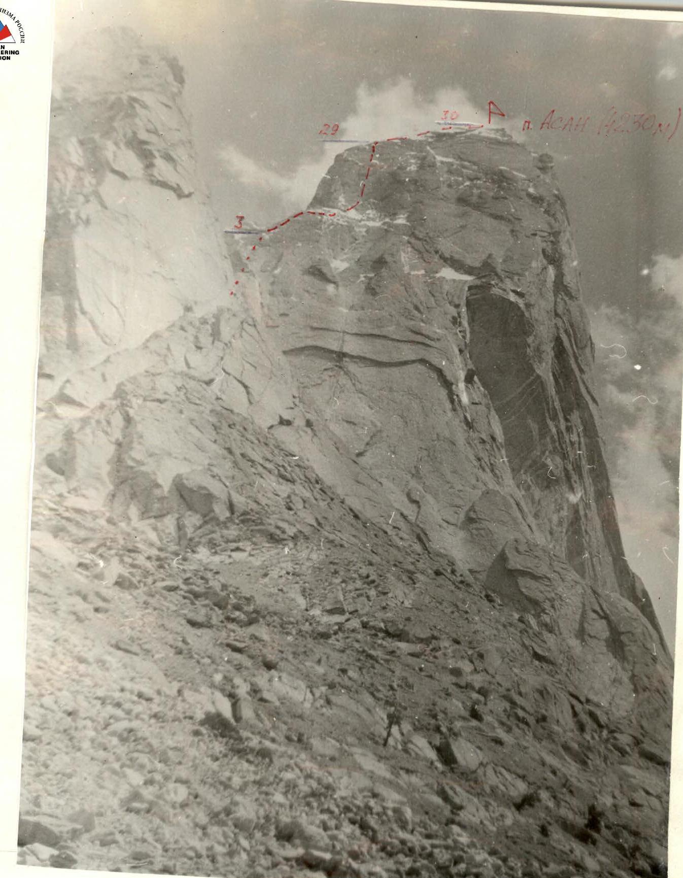
General photo of the peaks
Peak Asan (4230 m).
June 20, 1988 13:00 — VOLNA-3 lens, Φ-80 mm.
Height of the shooting point 3400 m.
Distance — 1.2 km.
--- team's route; .... invisible part of the route.
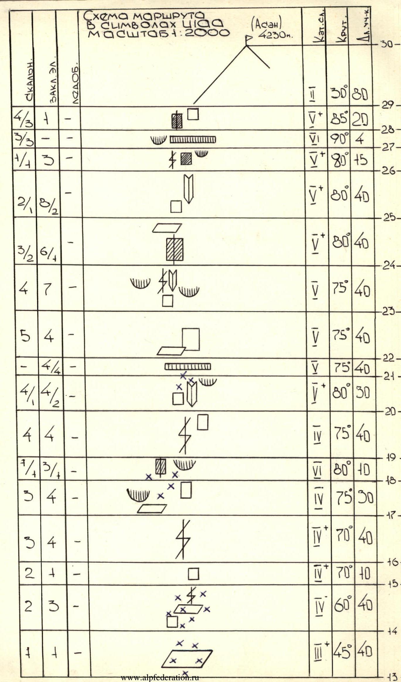
Route diagram in symbols
Scale 1:2000 (Asan 4230 m).
| R-number | Rock | Chocks | Ice screws | Steepness | Category of difficulty | Section length (m) |
|---|---|---|---|---|---|---|
| R30 | ||||||
| R29 | 4/3+ | — | 30° | 1 | 80 | |
| R28 | 3/3 | — | 85° | 5 | 20 | |
| R27 | 1/4 3 | — | 90° | 5 | 4 | |
| R26 | 2/8/2 | — | 80° | 5 | 5 | |
| R25 | 3/2 6/4 | — | 80° | 5 | 40 | |
| R24 | 4 7 | — | 80° | 5 | 40 | |
| R23 | 5 4 | — | 75° | 5 | 40 | |
| R22 | 4/4 | — | 75° | 5 | 40 | |
| R21 | 4/1 4/2 | — | 75° | 5 | 40 | |
| R20 | 4 4 | — | 80° | 5 | 30 | |
| R19 | 1/4 3/4 | — | 75° | 4 | 40 | |
| R18 | 3 4 | — | 80° | 6 | 10 | |
| R17 | 3 4 | — | 75° | 4 | 30 | |
| R16 | 2 | + | — | 70° | 4 | 40 |
| R15 | 2 3 | — | 70° | 5 | 10 | |
| R14 | 1 | + | — | 60° | 4 | 40 |
| R13 | 2 | + | — | 80° | 5 | 8 |
| R12 | 1 | — | — | 40° | 2 | 30 |
| R11 | + | + | — | 80° | 5 | 6 |
| R10 | — | + | — | 30° | 1 | 40 |
| R9 | + | 1/2 | — | 95° | 5 | 5 |
| R8 | 2/3 | 1 | — | 90° | 5 | 40 |
| R7 | 2 | + | — | 70° | 4 | 40 |
| R6 | 2 | — | — | 60° | 4 | 40 |
| R5 | + | 1/4 | — | 90° | 5 | 6 |
| R4 | + | 2 | — | 60° | 4 | 40 |
| R3 | 1 | + | — | 50° | 1 | 40 |
| R2 | 1 | — | — | 45° | 1 | 40 |
| R1 | 1 | — | — | 45° | 1 | 40 |
| R0 | FITO | — | — |
Description of the route by sections
APPROACH TO THE ROUTE: Ascend along the trail into the cirque formed by: Peak Kotina – Peak 4B10 – Peak Usan – Peak Asan, then, crossing scree and small snowfields from left to right, we come under the eastern side of the counterfort of the North wall of Peak Asan.
Sections R0–R3: Ascend along gentle rocks and scree ledges with small walls.
Sections R3–R9: Ascend to the shoulder of the counterfort along steep rocks. Rich terrain, presence of many cracks and ledges greatly facilitates climbing and belaying.
Sections R9–R15: Traverse along inclined slabs under the wall of the Peak Asan tower. There are sections with wet snow.
Sections R15–R29: The summit tower is a steep, monolithic rock wall. The ascent is via a series of internal corners and crevices. Micro-relief. Climbing is difficult. Especially difficult are the transitions from one internal corner or crevice to the next. Passing the last 2 ropes (sections R25–R29) to the summit ridge is complicated by the presence of:
- meltwater on the rocks,
- flow ice in the cracks,
- small rock cornices, which require the use of FITO.
Section R29–R30: Summit ridge. Does not present technical difficulties.
Descent is via the ascent route.