Ascent Passport
-
Ascent class — technical
-
Ascent area — Pamir-Alay, Turkestan Range
-
Peak 4750 (p.LOMO), via the North Ridge, combined route, third ascent.
-
Proposed difficulty category — 5B
-
Route characteristics:
- Length — 1950 m
- Length of sections with II–IV difficulty category — 400 m
- Of which VI difficulty category — 75 m
- Average steepness of the wall section — 64°
- Elevation gain — 1150 m
-
Pitons used:
| Rock | Bolt | Placement elements | Protrusions | Ice |
|---|---|---|---|---|
| 70 | 1 | 20 | 38 | 10 |
| 10 | 0 | 1 | 0 | 0 |
-
Total climbing hours — 34, days — 4
-
Overnight bivouacs.
-
Group composition:
- Buchinsky Alexander Vladimirovich — 1st sports category, leader
- Ivanov Alexey Nikolaevich — CMS
- Lenivkova Zinaida Dmitrievna — MS
- Matveycheva Lyubov Dmitrievna — CMS
- Pashkevich Alexander Viktorovich — 2nd sports category
-
Team coach MS USSR Lenivkova Zinaida Dmitrievna II difficulty category
-
Departure to the route — June 21, 1988 Summit reached — June 24, 1988 Return to base camp — June 24, 1988
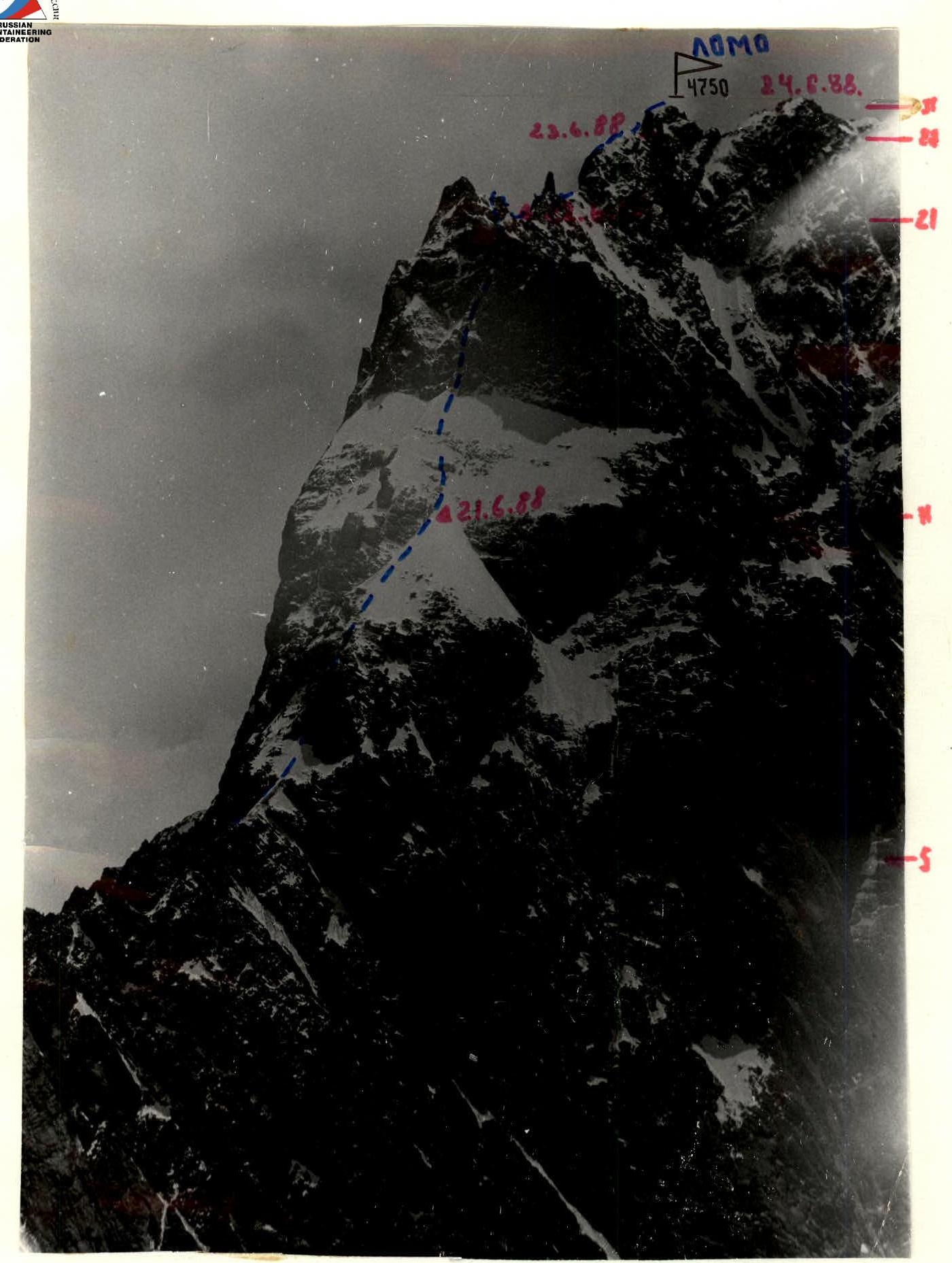
Photo 1. Date taken June 25, 1988. Lens "Industar-50". Distance — 1000 m. Shooting height — 3700 m.
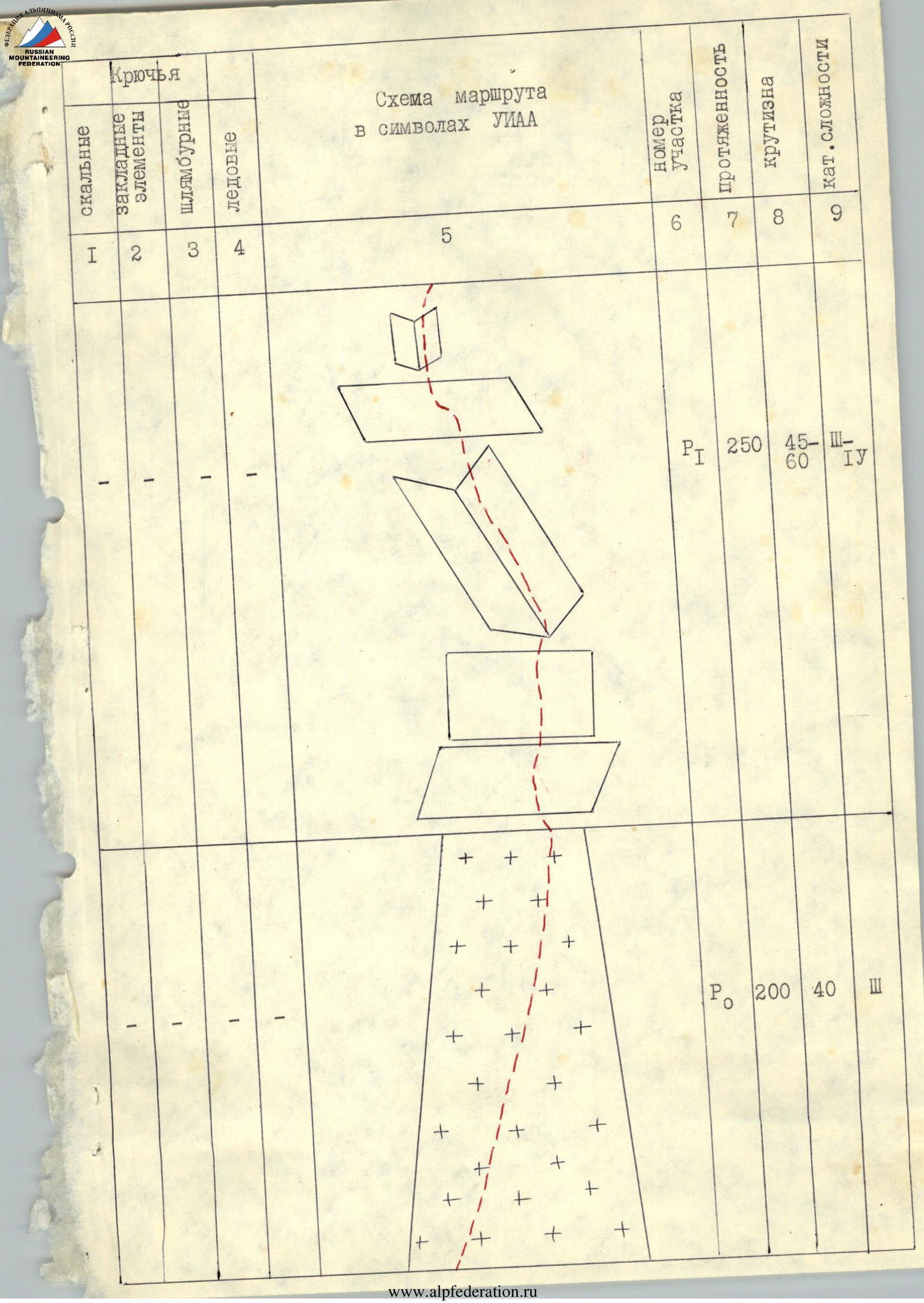
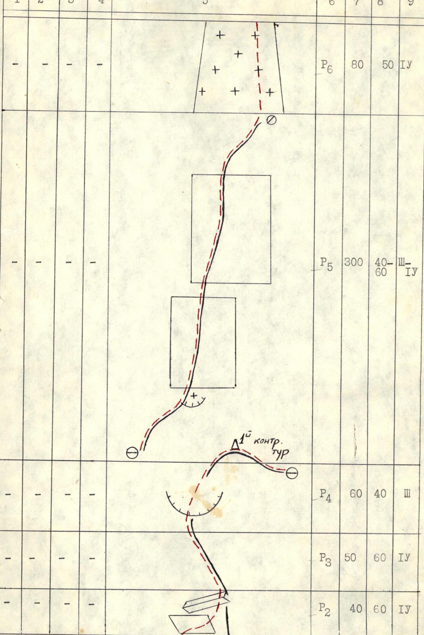
Route scheme in UIAA symbols
| Section # | Rock pitons | Placement elements | Bolt pitons | Ice pitons | Length (m) | Steepness (°) | Difficulty category | Notes |
|---|---|---|---|---|---|---|---|---|
| R0 | — | — | — | — | 200 | 40 | 3 | |
| R1 | — | — | — | — | 250 | 45–60 | 4 | |
| R2 | — | — | — | — | 40 | 60 | 4 | |
| R3 | — | — | — | — | 50 | 60 | 4 | |
| R4 | — | — | — | — | 60 | 40 | 3 | |
| R5 | — | — | — | — | 300 | 40–60 | 4 | |
| R6 | — | — | — | — | 80 | 50 | 4 | |
| R7 | 4 | — | — | — | 20 | 85 | 4 | |
| R8 | 2 | — | — | — | 20 | 38 | 5 | |
| R9 | 4 | — | — | — | 40 | 60 | 4 | |
| R10 | — | — | — | — | 120 | 45–55 | 4 | |
| R11 | — | — | — | — | 80 | 50 | 1 | |
| R12 | 2 | — | — | 2 | 40 | 55 | 5 | |
| R13 | 4 | — | — | — | 20 | 80 | 5 | |
| R14 | 4 | 1 | — | — | 20 | 80 | 5 | traverse |
| R15 | 2 | 1 | — | — | 40 | 80 | 5 | |
| R16 | 2 | — | — | — | 20 | 70 | 5 | 2nd control belay |
| R17 | 2 | — | — | — | 35 | 80 | 6 | |
| R18 | 3 | — | — | — | 10 | 70 | 5 | |
| R19 | 3 | — | — | — | 15 | 80 | 5 | traverse 15 m |
| R20 | — | — | — | — | 40 | 85 | 4 | |
| R21 | — | 2 | — | — | 40 | 50 | 4 | Overnight on June 22, 1988, 4500 m |
| R22 | — | 2 | — | — | 60 | 55 | 4 | |
| R23 | — | 2 | — | — | 60 | 30 | 3 | |
| R24 | — | — | — | — | 60 | 40 | 3 | |
| R25 | — | 1 | — | — | 40 | 30 | 3 | |
| R26 | — | 1 | — | — | 40 | 70 | 5 | |
| R27 | — | 1 | — | — | 40 | 50 | 3 | Overnight on June 23, 1988, 4650 m |
| R28 | — | 1 | — | — | 40 | 75 | 5 | |
| R29 | — | 1 | — | — | 30 | 45 | 3 | |
| R30 | — | 1 | — | — | 40 | 75 | 5 |