PASSPORT
- Technical class.
- Pamir-Alai, Ak-Su gorge.
- Peak Iskander North, 5000 m, via the left edge of the Eastern wall.
- Proposed 5B category of difficulty, first ascent.
- Route characteristics: wall section height difference — 900 m, total route height difference — 1120 m, total route length — 1560 m, length of sections with 5–6 category of difficulty — 450 m, length of sections with 6 category of difficulty — 170 m, average steepness of the wall section — 65°, average steepness of the entire route — 60°.
- Pitons hammered:
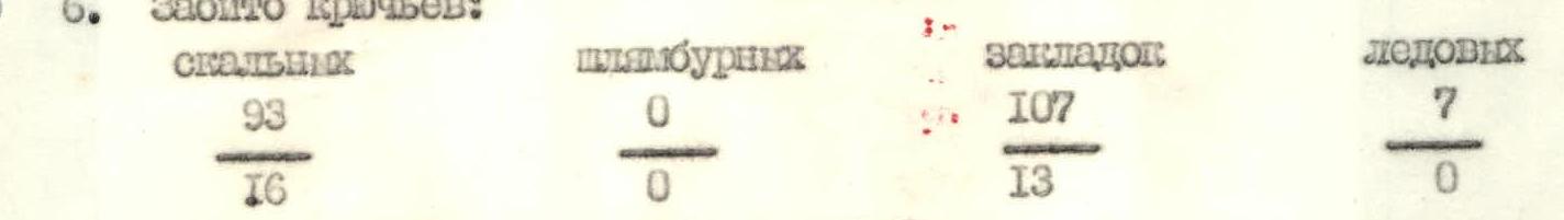
rock bolt chock ice 93 0 107 7 16 0 13 0 - Team's climbing hours: 45 hours and days: 5.
- Overnights: 4 on the ascent, 1 on the descent. All overnights were bivouac in a tent.
- Leader: Katachkov S.V. — CMS Team members: Alparov A.N. — CMS Kerbi S.B. — CMS Severov P.B. — CMS Shcherbakov A.I. — CMS
- Senior coach: Shpolyansky V.N. — CMS Coach: Barkin A.I. — CMS
- Approach to the route: July 8, 1986. Summit: July 12, 1986. Return: July 13, 1986.
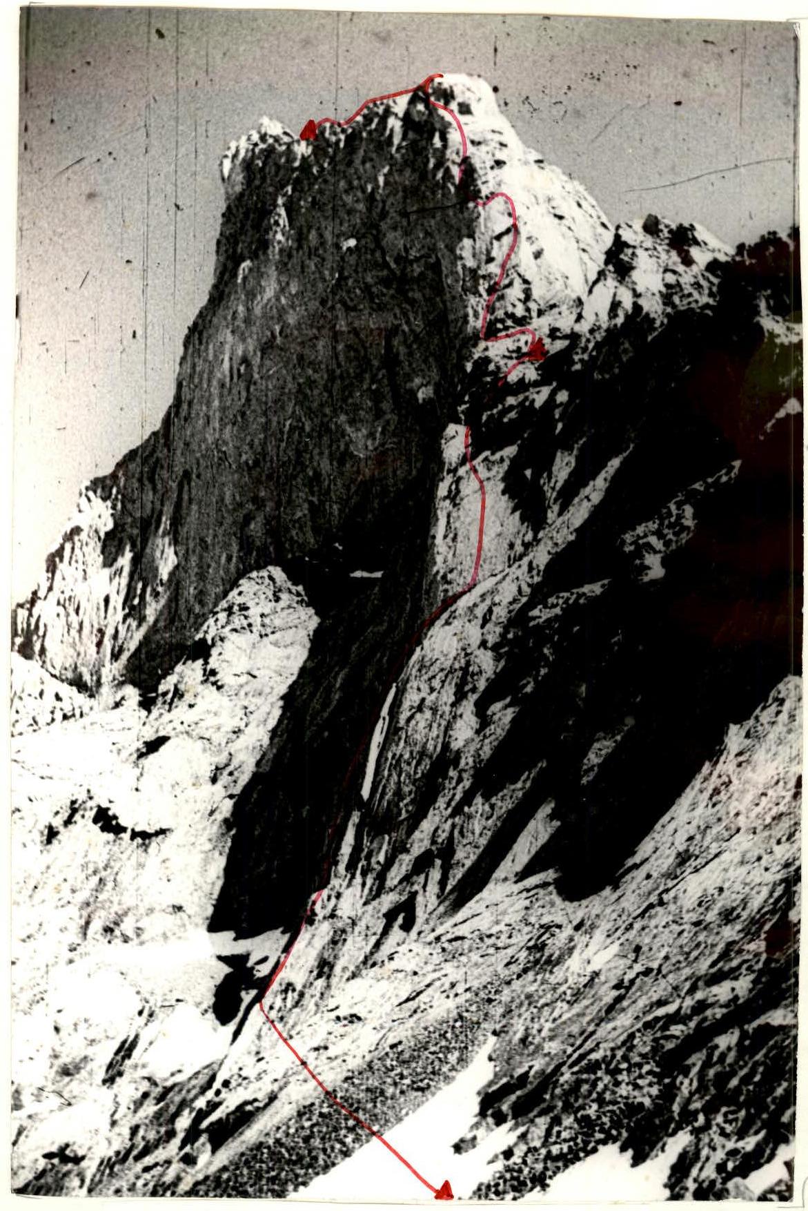
Photo #1. General photo of the summit. July 5, 1986. 15:00. Camera "Smena". P = 0.7 mm, H ± 3500 m. On July 8, 1986, at 11:00, the pair Kerbi — Severov left the assault camp on the moraine to process the lower part of the route. They took all 6 ropes, a significant number of rock pitons, and chock stones. At 12:00, they began processing the buttress. Severov worked first on a double rope with a lightened backpack, wearing galoshes. The second straightened the rope, knocked out intermediate pitons, and securely fixed the rope on double or even triple anchors. The rocks were monolithic, and the climbing was reliable and pleasant (photo 4). The first climber passed steep walls without a backpack using ladders and extension cords (photo 5). At 18:00, five ropes were fixed up to a steep 120-meter wall with two parallel vertical cracks, a small cache was made, and the further ascent path was planned. At 20:00, the pair descended to the tent on the moraine using descenders. On July 9, 1986, at 7:00, the group began moving along the previously fixed ropes with full gear. At 9:00, the pair Severov — Kerbi started passing the 120-meter monolithic wall with vertical cracks. Severov worked first. The lower 20-meter section of the wall with a steepness of 90° up to the beginning of the right crack was passed using frequent pitons, extension cords, and small chock stones. The trio Katachkov — Alparov — Shcherbakov removed the fixed ropes during this time. The first climber worked on a double rope without a backpack. The crack was not wide, and large and medium-sized chock stones were used. Kerbi and the trio ascended using ascenders with top rope, pulling up the first climber's backpack. The wall turned into a system of ledges leading to the shoulder of a rock outcrop (photo 6). An unpleasant 100-meter section of steep, heavily destroyed rocks was passed with extreme caution: double rope, top rope, and accompaniment of the first climber's backpack by one of the team members. At 18:00, the group reached the South-East ridge of Iskander under the edge of the Eastern wall. Excellent overnight stay. On July 10, 1986, processing of the edge of the Eastern wall — the key section of the route. At 8:00, two pairs went out to process: Kerbi — Severov and Alparov — Shcherbakov. The passage of the sheer "red" wall-plate with a large overhanging cornice was problematic. Severov passed the wall in its left part using a system of vertical cracks (photo 7), turning into a slightly expanding inclined chimney leading to a small ledge to the right of the cornice. Extremely difficult climbing using the entire arsenal of technical means. Alparov ascended second, knocking out intermediate pitons and straightening the rope, using the fixed ropes. An unpleasant pendulum swing to the right. At 13:00, the rested pair Alparov — Shcherbakov moved forward. Alparov worked first, passing a complex inner corner using artificial aids and reaching a horizontal ledge under the second cornice. Having fixed two ropes up to the middle of the bastion with two parallel steep inner corners, Shcherbakov — Alparov descended to the overnight stay in the tent on the SE ridge at 17:00, following the pair Kerbi — Severov. 4.5 ropes were fixed during the day. A plan for the next day's work was made. The goal was to reach the Eastern ridge of Iskander Main. On July 11, 1986, at 7:00, we began the ascent using the fixed ropes (photo 8). The pair Alparov — Shcherbakov worked first, with Shcherbakov leading (without a backpack), finishing the passage of the sheer bastion (0.5 rope), overcoming a gentle inner corner (2 ropes), an inclined 50° slab with cracks (2 ropes), and reaching under the third belt of overhanging cornices (photo 9). The rest of the team moved along the fixed ropes at a pace that did not hinder the first climber's work. Using artificial aids, Shcherbakov bypassed the cornices on the left along an 80° wall (photos 9 and 10), reached the South wall at the base of a sheer inner corner (where his rock hammer broke), passed a 30-meter vertical wall (extremely difficult climbing) (photo 11), and at 17:00 reached the Eastern ridge of Iskander Main. At 18:00, the last team member, Kerbi, ascended to the ridge using the fixed ropes with top rope, having removed the pitons. Having gathered together and rested a bit, we began simultaneous movement along the Eastern ridge towards the summit of Iskander Main, choosing a place for a bivouac site. At 20:00, Kerbi, Katachkov, and Severov finished arranging the bivouac. The pair Alparov — Shcherbakov returned, having fixed 80 meters of ropes for the next day. We followed the tactical plan strictly. On July 12, 1986, at 8:00, leaving the bivouac gear behind, we began moving lightly along a snow-rock ledge, then traversed a snow-ice slope under the summit tower of Iskander North. Kerbi worked first. Insurance was provided using ice screws and ice axes. Having overcome 120 meters of rocks with steep walls, at 10:20, we reached the summit of Iskander North. We found a note from the "Spartak" Sports Club. At 10:40, we began the descent via the ascent route. At 20:00, the entire group gathered at the overnight stay on the SE ridge under the key section of the route. On July 13, 1986, at 9:00, we continued the descent via the ascent route and met the support group at 16:00.
Conclusions:
- The planned tactical plan for the route was fully executed.
- The correct tactics allowed the team to complete the route at a good pace with very high reliability.
- The equipment selected for the ascent fully justified itself.
- The nutrition plan, calculated at 400 g per person per day, was sufficient for intense work.
- The route passed was complex in terms of technical, physical, psychological, and tactical criteria and undoubtedly corresponds to the 5B category of difficulty.
- Three-time communication with the camp using the "Kaktus" radio was reliable, and there were no cases of communication loss.
- The team considers the route safe for passage.
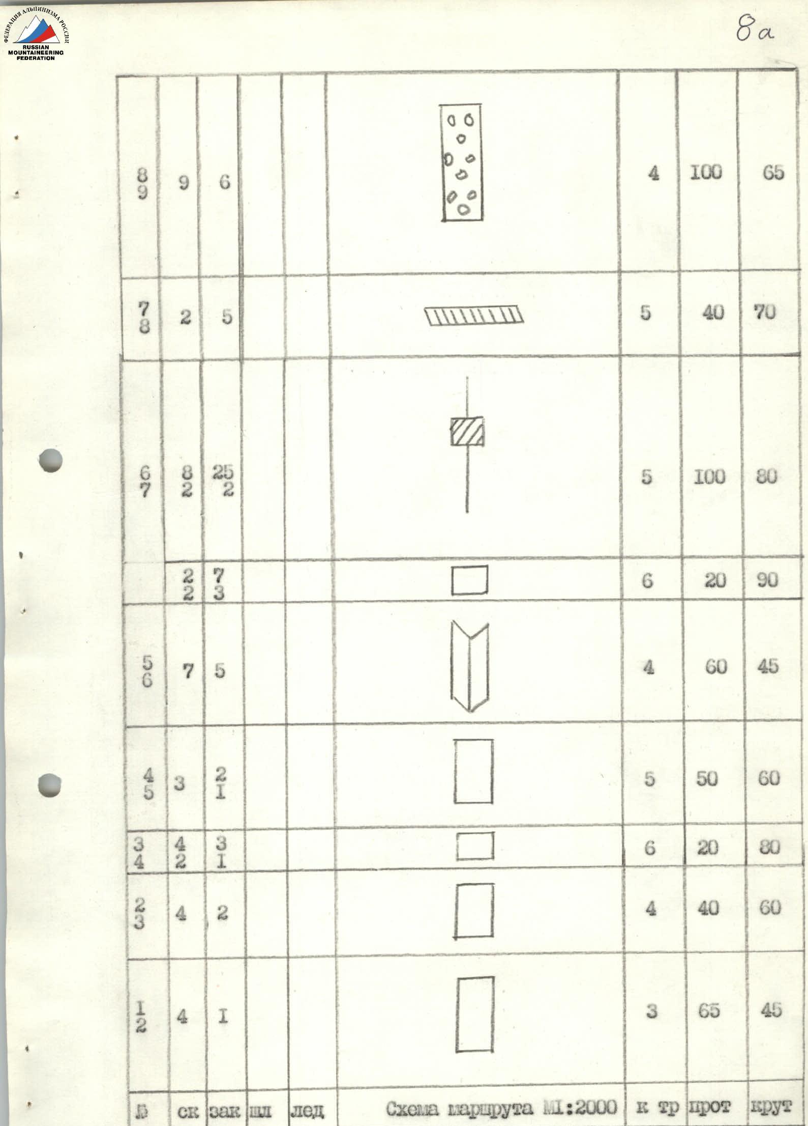
| Section | Rock pitons | Chock stones | Bolt pitons | Ice pitons | Route diagram M:2000 | Category of difficulty | Length | Steepness |
|---|---|---|---|---|---|---|---|---|
| R1–R2 | 4 | 1 | 3 | 65 m | 45° | |||
| R2–R3 | 4 | 2 | 4 | 40 m | 60° | |||
| R3–R4 | 2 | 1 | 6 | 20 m | 80° | |||
| R4–R5 | 3 | 2 | 5 | 50 m | 60° | |||
| R5–R6 | 7 | 5 | 4 | 60 m | 45° | |||
| R6–R7 | 8 | 2 | 5 | 5 | 100 m | 80° | ||
| R7–R8 | 2 | 5 | 5 | 40 m | 70° | |||
| R8–R9 | 6 | 4 | 100 m | 65° | ||||
| R9–R10 | 2 | 2 | 4 | 40 m | 50° | |||
| R10–R11 | 3 | 8 | 2 | 6 | 50 m | 85° | ||
| R11–R12 | 8 | 5 | 1 | 6 | 50 m | 85° | ||
| R12–R13 | 5 | 4 | 1 | 5 | 40 m | 80° | ||
| R13–R14 | 5 | 10 | 4 | 100 m | 55° | |||
| R14–R15 | 7 | 5 | 4 | 100 m | 50° | |||
| R15–R16 | 7 | 5 | 6 | 30 m | 90° | |||
| R16–R17 | 3 | 1 | 5 | 30 m | 80° | |||
| R17–R18 | 1 | 1 | 7 | 4 | 240 m | 10° | ||
| R18–R19 | 1 | 1 | 3 | 200 m | 30° | |||
| R19–R20 | 2 | 1 | 4 | 120 m | 45° |
ROUTE DESCRIPTION BY SECTIONS
Section R0–R1. Snow, scree slope, slabs. Section R1–R2. Beginning of a not clearly defined buttress, slightly destroyed rocks with a steepness of 45°–50°. Section R2–R3. Rocks of medium difficulty (50°–60°) with a large number of holds. Section R3–R4. 20-meter monolithic rocks with a steepness of 75°–85°, using artificial aids, pulling up the backpack; exit to a small ledge with a control cairn. Section R4–R5. Smooth 60° slab with a very small number of holds (artificial aids, pulling up the backpack), turning into a not clearly defined inner corner. Section R5–R6. Expanding inner corner, smoothly turning into an inclined ledge of a steep wall with two parallel vertical cracks. Section R6–R7. 120-meter monolithic wall with a steepness of 75°–85°. Passed via the right vertical crack using mainly large chock stones. In the lower part of the wall — a 20-meter section of 90° extremely difficult climbing (artificial aids, pulling up backpacks). Section R7–R8. System of ledges leading to the shoulder of a small rock outcrop. Section R8–R9. 100 meters of steep, heavily destroyed rocks. Extreme caution is necessary. Exit to the South-East ridge. Excellent overnight stay. Section R9–R10. 50° wall, diagonal ledge to the left upwards, system of large blocks. Section R10–R11. 85° "red" wall-slab with a cornice. Passed vertically upwards via a crack, then in a chimney under the cornice to the right upwards to a small ledge to the right of the cornice. 50 meters of extremely difficult climbing using artificial aids. Section R11–R12. Chimney with ice, turning into an 85° inner corner. Ascent via the right part of the corner using artificial aids to a horizontal ledge. Along the ledge to the left 10 meters under the second cornice at the base of two inner corners. Section R12–R13. Two parallel steep inner corners 75°–85°. Ascent via the right corner 40 meters to a convenient ledge. Monolithic rocks. Reliable, pleasant climbing. Section R13–R14. 100-meter wide inner corner with a steepness of 50°–55°. Section R14–R15. Inclined 100-meter slab with cracks. Steepness 50°. Overhanging third belt of cornices above. Section R15–R16. 80° wall. Bypass of the cornice on the left using artificial aids. Small traverse to the left onto the South wall at the base of a sheer inner corner. Section R16–R17. 30-meter vertical wall. Extremely difficult climbing, artificial aids. Exit to the Eastern ridge of Iskander Main. Section R17–R18. Heavily destroyed ridge, 200 meters under the summit tower of Iskander Main. Bivouac on a prepared site. Section R18–R19. Along a snow-scree ledge 40 meters to the right, then traverse 200 meters along a snow-ice slope under the summit tower of Iskander North. Section R19–R20. Summit tower of Iskander North. 120 meters of несложных скал.