Passport
- Technical class.
- Pamir-Alay, Turkestan Range, AkSu valley.
- Peak AkSu (C), 5217 m, via the direttissima of the northern wall bastion.
- Proposed - 6B category of difficulty, first ascent.
- Elevation gain – 1450 m, length – 1945 m, including 1030 m and 1140 m for the bastion respectively.
Length of sections with 5th category of difficulty – 350 m, 6th category – 905 m, including 200 m and 850 m on the bastion respectively.
Average steepness of the main part of the route – the bastion – 76°.
- Pitons hammered: rock, chocks, bolts, ice
| 125 | 250 | 87 | 10 |
|---|---|---|---|
| 62 | 90 | 76+6* | 6 |
Left on the route:
- rock pitons – 12
- chocks – none
- bolts – 8
- Team's working hours – 98, days – 10, including 3 days of processing.
- Overnights: 1st-5th on a platform, 6th on a site in a tent.
- Team leader: Klenov Alexander Valerievich, International Master of Sports, home address: 620144, Ekaterinburg, Sheinkmana st., 128–125.
Team members: Devi Mikhail Marenglenovich, International Master of Sports; Tarasov Sergey Kharitonovich, Master of Sports; Starov Vladimir Arnoldovich, Master of Sports; Pershin Mikhail Valerievich, Master of Sports; Anikin Mikhail Ivanovich, Candidate Master of Sports.
- Coach: Ostanin Viktor Vasilievich, Master of Sports, home address: 620003, Ekaterinburg, Krestinskogo st., 49, building 1, apt. 40.
- Entry to the route: July 22, 1996.
Reached the summit: July 31. Return: August 1.
- Organization: Committee for Physical Culture and Sports of the Sverdlovsk region. 620151, Ekaterinburg, Malysheva st., 60.
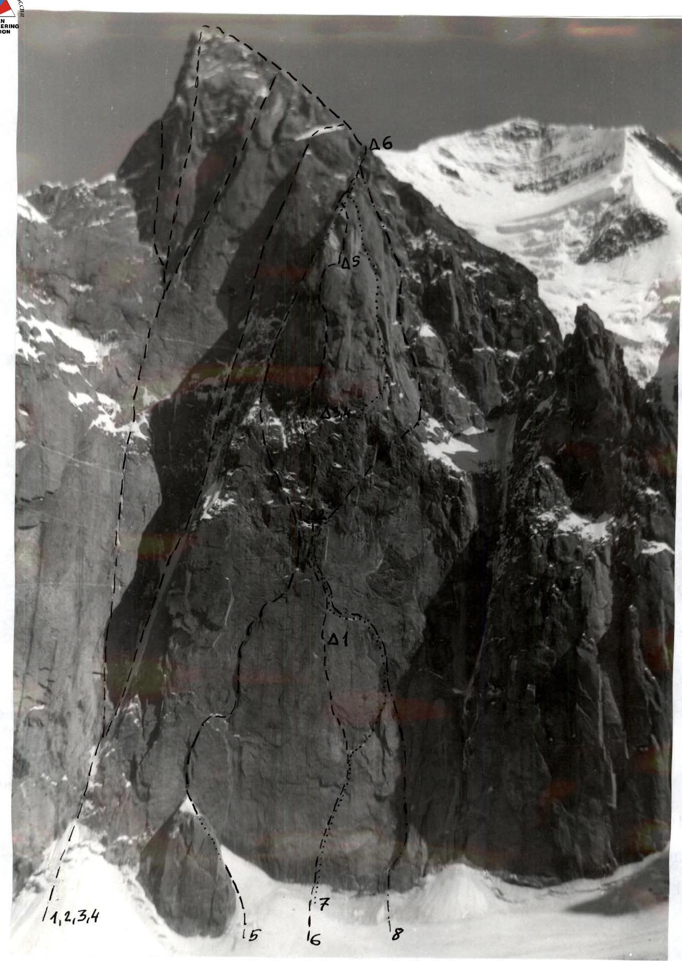
Photo 1. General photo of the summit. Date taken: July 25, 1996. Routes from left to right:
- 1-Popova
- 2-Shabalina
- 4-Moshnikova
- 5-Troshchinenko
- 6-team's route
- 7-Pershina
- 8-Vedernikova
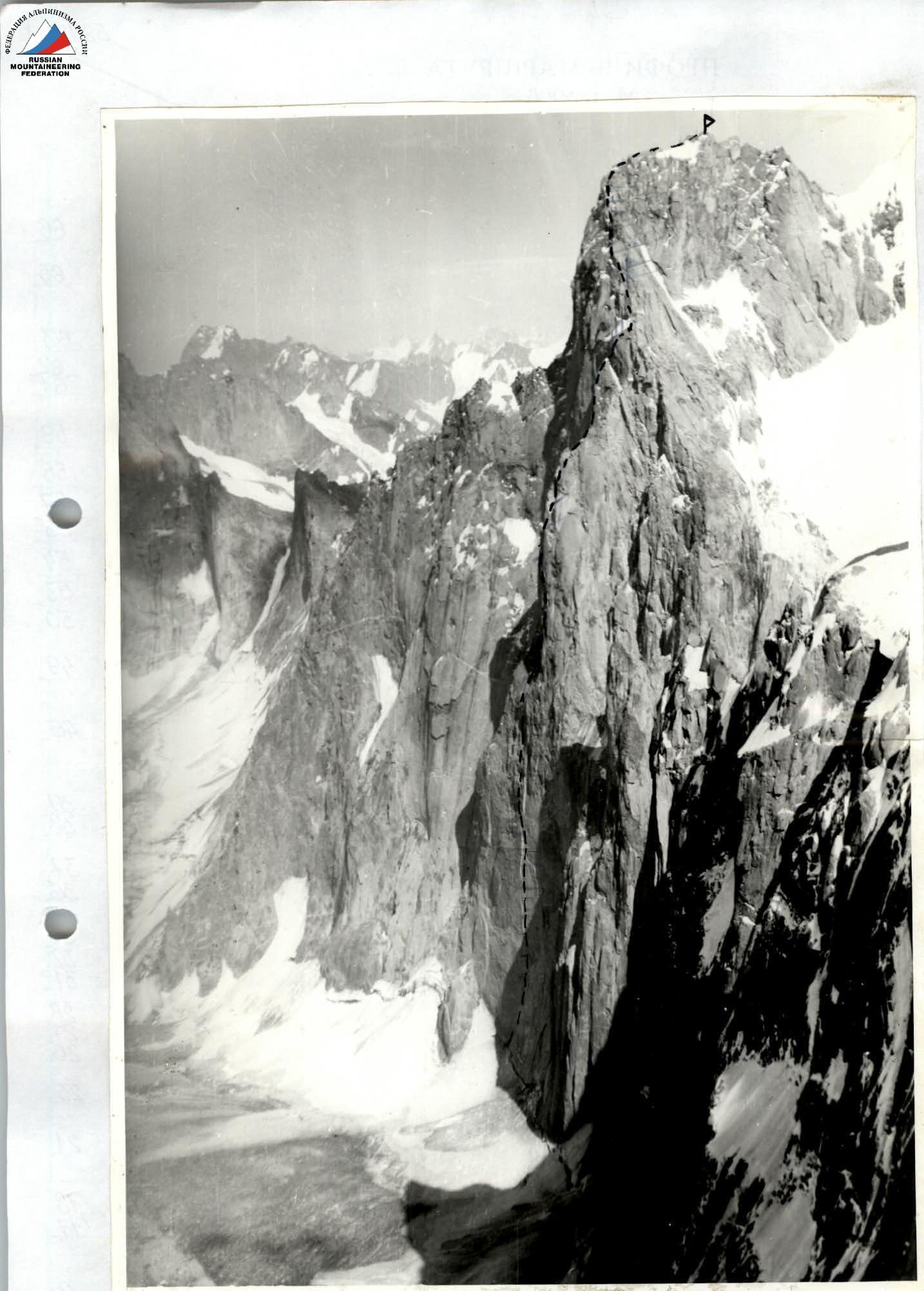
Photo 2. Route profile from the right.
ROUTE PROFILE M 1:5000
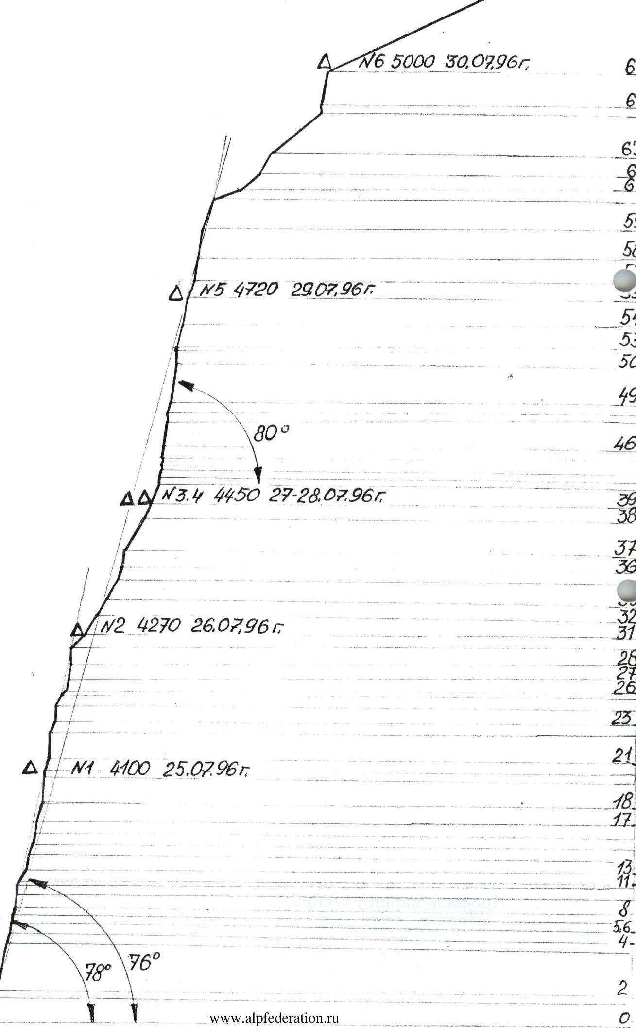
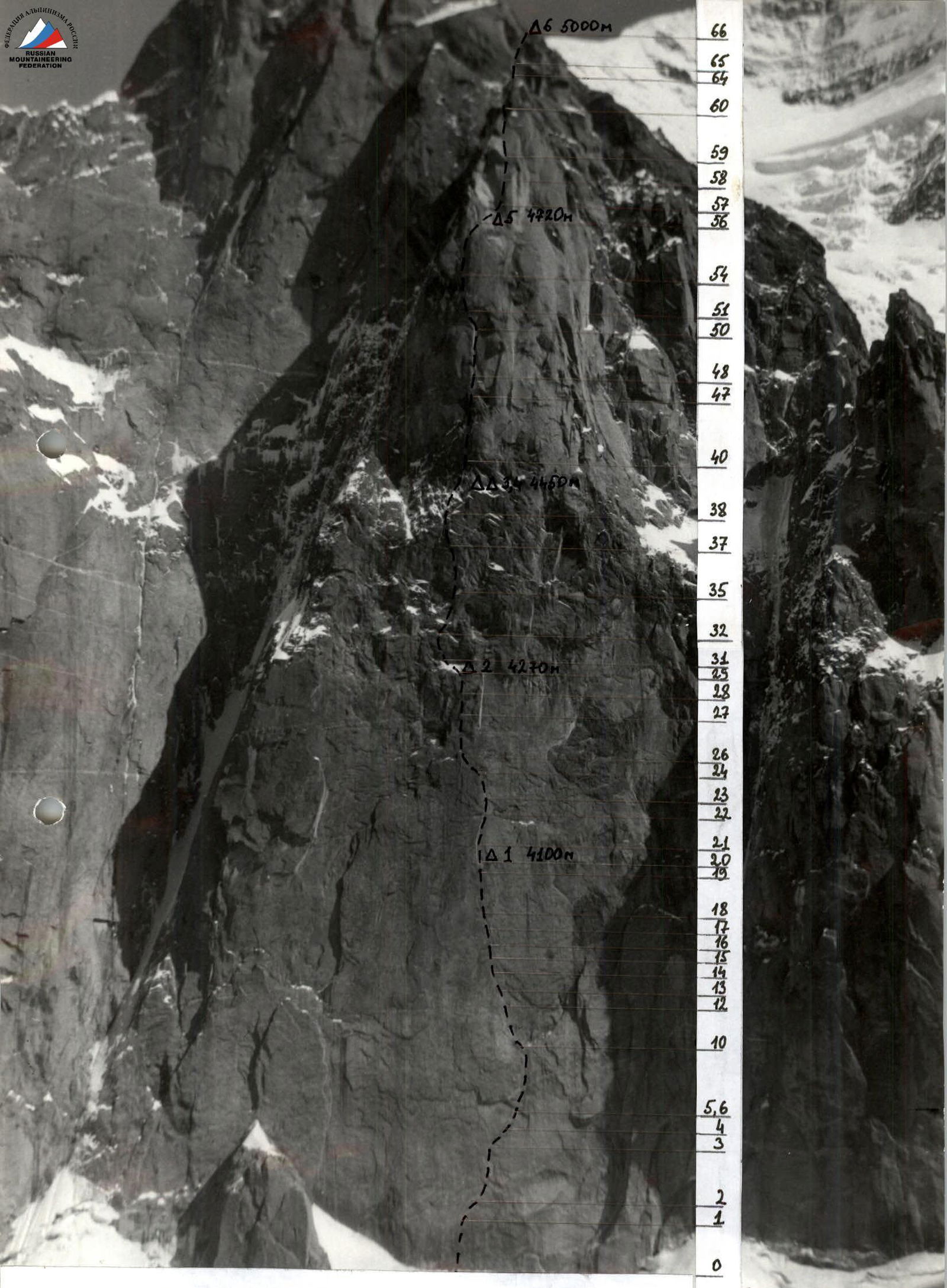
Photo 3. Technical photo of the route.
Tactical Actions of the Team
The team's tactical actions were shaped by previous experience in wall ascents, as well as the specifics of this ascent. The direttissima of the bastion beckoned many, but made everyone retreat or deviate to simpler and more gentle sections. Therefore, the team prepared with special thoroughness.
- Regular training on artificial and natural climbing walls
- Level of "free climbing" 6C+, 7A - the first pass for candidates to the team
- Special attention was paid to equipment
A tent with a platform for the entire team was made, allowing for a "roof over their heads" and satisfactory rest regardless of the terrain and weather conditions.
For the lower part of the route, the following were developed and manufactured:
- drill bits and bolt keys with a diameter of 6 and 8 mm of own design;
- sky hooks.
For the central part of the bastion, the following were developed and manufactured:
- additional numbers of "friends";
- "jack screws" allowing for belaying in cracks up to 40 cm in size.
Specially selected rock shoes and rubber on them allowed for a confident feel even on wet rocks. Knowledge of the meteorological statistics of the area allowed for choosing the optimal time for the ascent.
Since the lower part of the route is flooded due to snowmelt, processing with a change of rope in the middle of the day was целесообразной (reasonable). Further movement of the team was organized in a traditional way.
- The first moved without a backpack on a double rope (one with UIAA marking)
- One of the ropes was fixed as a handrail
- The rest moved along the handrails with backpacks with top or bottom belay
Each day, a designated rope team worked ahead, usually changing leaders in the second half of the day. Every participant worked as the first, allowing for an even distribution of the ascent load. During the organization of the bivouac, route processing was carried out.
Nutrition regime:
- Hot food in the morning
- Hot food in the evening
- Individual snacks during the day.
Throughout the entire route, there was stable radio communication with the base and observers.
A rescue team with the right to exit the route with a 6B category of difficulty was constantly present in the base camp.
Route Diagram in UIAA Symbols
M 1:2000
(sections less than 15 m and more than 100 m are not to scale)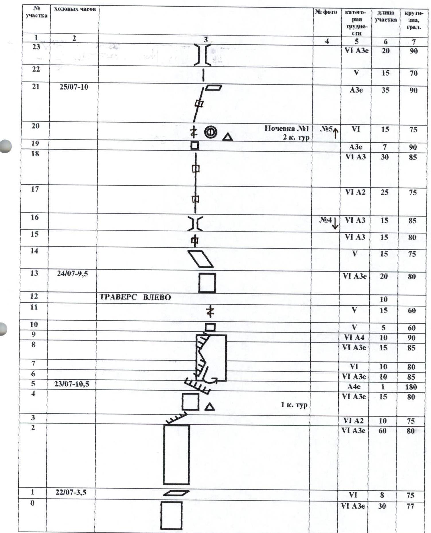
| Section # | Working Hours | Photo # | Category of Difficulty | Section Length | Steepness, ° |
|---|---|---|---|---|---|
| 0 | July 22 (3 h 30 min) | VI A3e | 30 m | 77° | |
| 1 | VI | 8 m | 75° | ||
| 2 | VI A2 | 10 m | 75° | ||
| 3 | VI A3e | 60 m | 80° | ||
| 4 | July 23 (10 h 30 min) | VI A3e | 15 m | 80° | |
| 5 | A4e | 1 m | 180° | ||
| 6 | VI A3e | 10 m | 85° | ||
| 7 | VI | 10 m | 80° | ||
| 8 | VI A3e | 15 m | 85° | ||
| 9 | VI A4 | 10 m | 90° | ||
| 10 | V | 5 m | 60° | ||
| 11 | TRAVERSE LEFT | V | 15 m | 60° | |
| 12 | 10 m | ||||
| 13 | July 24 (9 h 30 min) | VI A3e | 20 m | 80° | |
| 14 | V | 15 m | 75° | ||
| 15 | #4 | VI A3 | 15 m | 80° | |
| 16 | VI A3 | 15 m | 85° | ||
| 17 | VI A2 | 25 m | 75° | ||
| 18 | A3e | 7 m | 90° | ||
| 19 | Overnight #1 (2 tur) #5↑ | VI A3 | 30 m | 85° | |
| 20 | July 25 (10 h 00 min) | VI | 15 m | 75° | |
| 21 | V | 15 m | 70° | ||
| 22 | V | 15 m | 70° | ||
| 23 | A3e | 35 m | 90° | ||
| 24 | V | 15 m | 65° | ||
| 25 | #6 | III | 8 m | 45° | |
| 26 | VI A3 | 15 m | 80° | ||
| 27 | VI A3 | 20 m | 80° | ||
| 28 | A3e | 20 m | 90° | ||
| 29 | Overnight #2 ++ | III | 20 m | 45° | |
| 30 | TRAVERSE LEFT ++ | 20 m | |||
| 31 | V | 30 m | 60° | ||
| 32 | V | 25 m | 60° | ||
| 33 | July 26 (11 h 30 min) | V | 30 m | 60° | |
| 34 | TRAVERSE RIGHT | 10 m | |||
| 35 | V | 15 m | 70° | ||
| 36 | VI A2e | 20 m | 85° | ||
| 37 | V+ A1e | 45 m | 60° | ||
| 38 | #7 | V+ | 20 m | 65° | |
| 39 | #8 Diagonal rappel 30 m to overnight #3–4 | V+ | 25 m | 65° | |
| 40 | A3 | 10 m | 85° | ||
| 41 | VI | 10 m | 75° | ||
| 42 | A3 | 5 m | 95° | ||
| 43 | A2 | 5 m | 75° | ||
| 44 | July 27 (12 h 30 min) | A3 | 5 m | 100° | |
| 45 | VI A3 | 15 m | 85° | ||
| 46 | VI A3e | 30 m | 80° | ||
| 47 | July 28 (10 h 30 min) | A3 | 10 m | 95° | |
| 48 | #9 | VI A2 | 15 m | 75° | |
| 49 | VI A3 | 50 m | 80° | ||
| 50 | A3 | 15 m | 90° | ||
| 51 | 3 tur Δ | A3 | 2 m | 180° | |
| 52 | VI A3 | 5 m | 95° | ||
| 53 | VI A2 | 30 m | 75° | ||
| 54 | VI A3 | 35 m | 80° | ||
| 55 | Rappel 15 m to overnight #5 | V | 20 m | 70° | |
| 56 | TRAVERSE RIGHT | 20 m | |||
| 57 | 4 tur Δ | VI A2 | 30 m | 80° | |
| 58 | VI A2 | 40 m | 80° | ||
| 59 | VI | 40 m | 70° | ||
| 60 | II | 30 m | 20° | ||
| 61 | II | 30 m | 40° | ||
| 62 | IV | 30 m | 60° | ||
| 63 | V | 80 m | 40° | ||
| 64 | A3 | 10 m | 95° | ||
| 65 | July 30 (9 h 30 min) | VI A3 | 45 m | 80° | |
| 66 | Total to the summit – 98 (July 31 – 8 h) | Overnight #6 | IV–V | 500 m | 45° |
Route Description by Sections
Section R0–R1. Monolithic rock, overcome by extremely difficult climbing using bolt pitons and sky hooks. Landmark - a left bolt piton 20 m from the start of the route.
Section R2–R4. Right-up along monolithic rocks under an overhanging cornice.
Section R5–R9. Through the cornice straight on, up, pendulum right into a crack, then up the wall and overhanging zigzagging left-to-right corner.
Section R10–R12. Up by climbing under a vertical monolithic wall (to the right goes Pershin's route).
Section R13. Up using artificial aids on bolts (13 pieces).
Section R14–R19. Up along a crack, sometimes turning into a chimney, to a small ledge where the 1st overnight stay is.
Section R20–R21. Overhanging left-to-right crack. To the right, Pershin's and Vedernikov's routes join.
Section R22–R24. Crack.
Section R25. Diagonal traverse left around a corner.
Section R26–R29. Up first along the terrain, then along a wall with old unreliable bolts to a steep snow ledge, just under the wall - overnight stay.
Section R30–R35. Bypassing the wall on the left, then right-up along walls and inner corners.
Section R37–R38. Left-up under a rock-snow belt, required changing rock shoes to crampons.
Section R39. Steep snow-ice couloir, belay on rocks. Diagonal rappel right onto a more gentle snowfield, where the overnight stay is.
Section R40–R45. Along the wall into an inner corner with varying slope, from there a pendulum right into another corner.
Section R46–R47. Monolithic rocks, overcome using bolt pitons, ending in an overhang. Exit onto a narrow horizontal ledge.
Section R48–R50. Inner corner turning into a crack, under a ceiling-type overhang.
Section R51–R52. Through the overhang along a crack, then a slot through an overhang.
Section R53–R54. Left-up along cracks and slabs.
Section R55. Right-up along a slab with flowstone.
Section R56. Traverse right along broken rocks. Overnight stay.
Section R57–R58. Difficult climbing and artificial aids, danger of loose rocks.
Section R59. Gradually flattening crack leading to the top of the bastion.
Section R60–R63. Ridge of the bastion, sometimes sharp and complex.
Section R64–R65. Initially over hanging, then vertical broken rocks, leading to the western ridge. A good site 20 m below.
Section R66. Extended, sometimes with bypasses on the left along snow-rock slopes of the ridge.
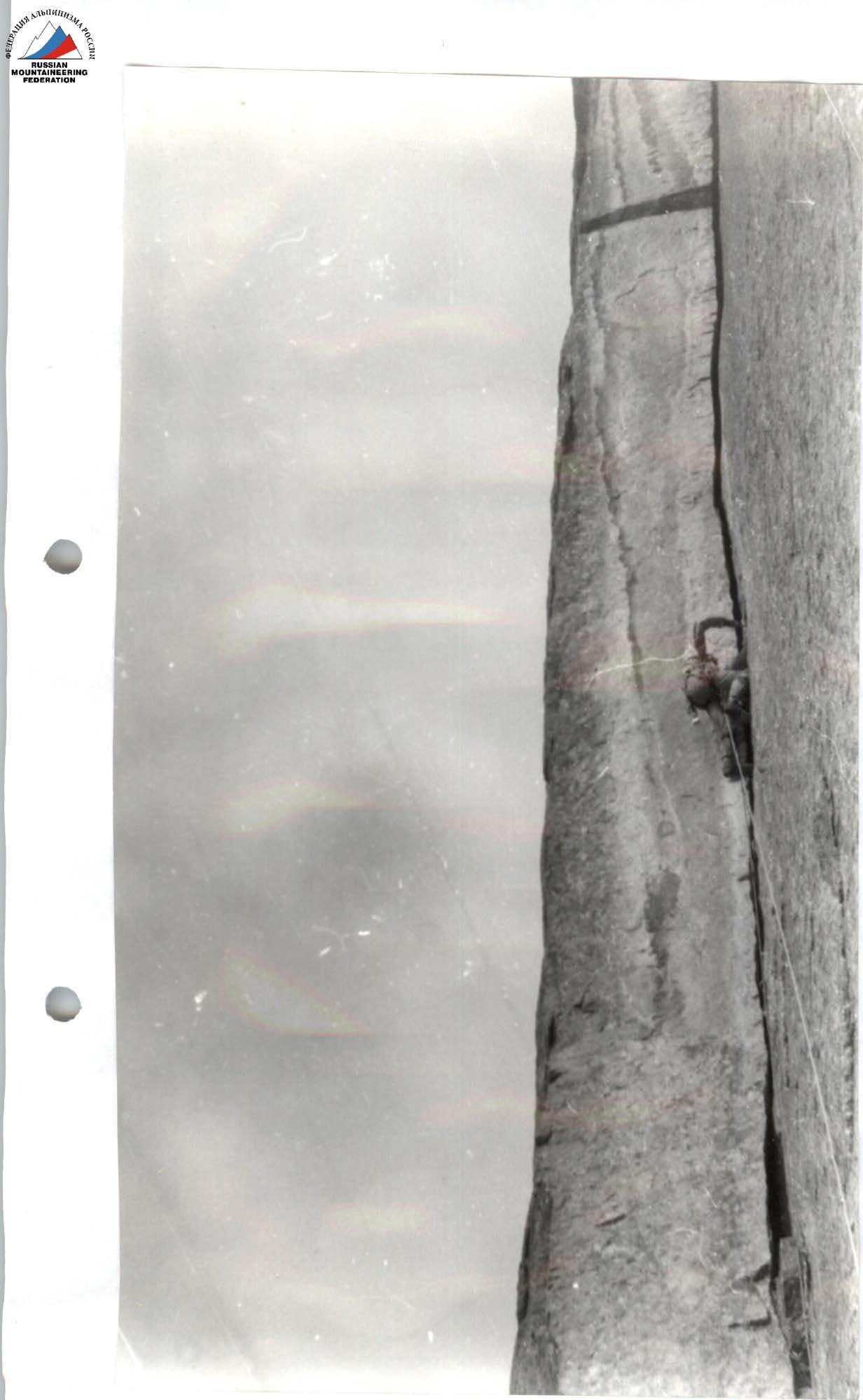
Photo 5. Movement of the first on section 21.