
Passport
- Category of wall climbing
- Turkestan Range, Minteke gorge
- Peak 4708 m (Bastille) via the right part of the NW wall “pillar”
- First ascent, proposed category 6B
- Height difference: 628 m, length — 650 m.
Length of sections with 5–6 difficulty category — 590 m. Average steepness of the wall section of the route — 83°. Average steepness of the route — 76°
- Pitons hammered:
| Rock | Bolt | Nuts (Friends) |
|---|---|---|
| 128 / 56 | 7+2* / 7+2* | 125 / 46 |
* — “hole” for a skyhook
- Team's climbing hours — 36 h and days — 4
- Overnight stays: one in hammocks.
- Team leader: Gennadiy Pavlovich Kiriyenksiy, Master of Sports of the USSR
Vitaliy Nikolaevich Kozlov, Candidate for Master of Sports, Aleksandr Vladimirovich Lapko, Master of Sports of the USSR, Boris Gennadievich Mineev, Candidate for Master of Sports
- Coach: Aleksandr Vladimirovich Lapko
- Approach to the route: July 25, 1994.
Summit: July 28, 1994. Descent: July 29, 1994.
- Organization: Chelyabinsk Regional Sports Committee
based on the team of the Alpinism Club of Magnitogorsk
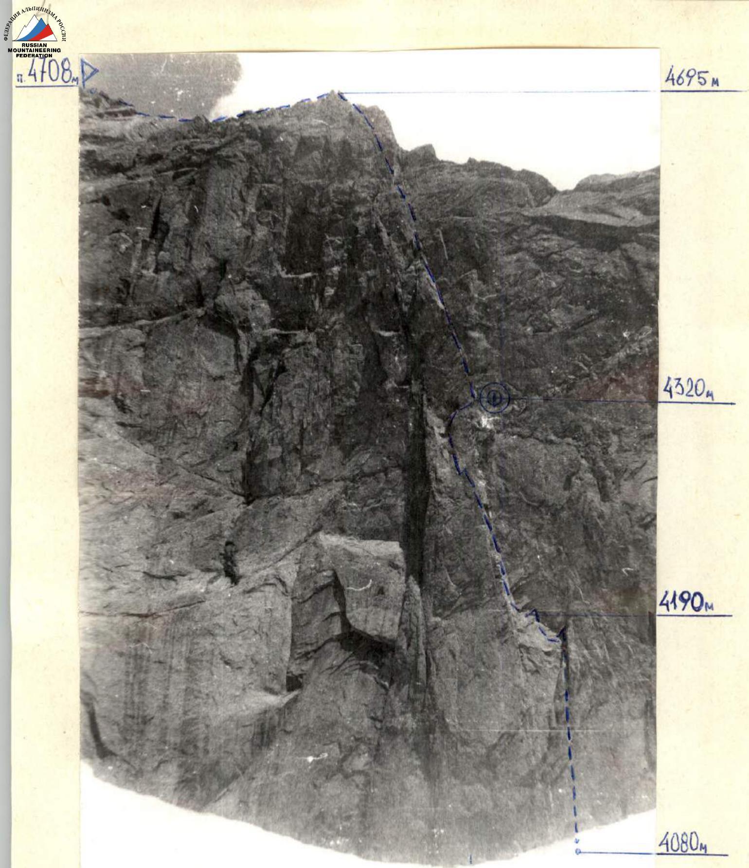
Photo 1. General photo of the summit.
- The route climbed by the team.
 4695 m
4320 m
4190 m
4080 m
4695 m
4320 m
4190 m
4080 m
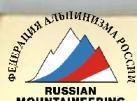
Photo 4. Panorama of the “left” cirque
- The route climbed by the team
- Route of the first ascent by Acad. A. Lapko
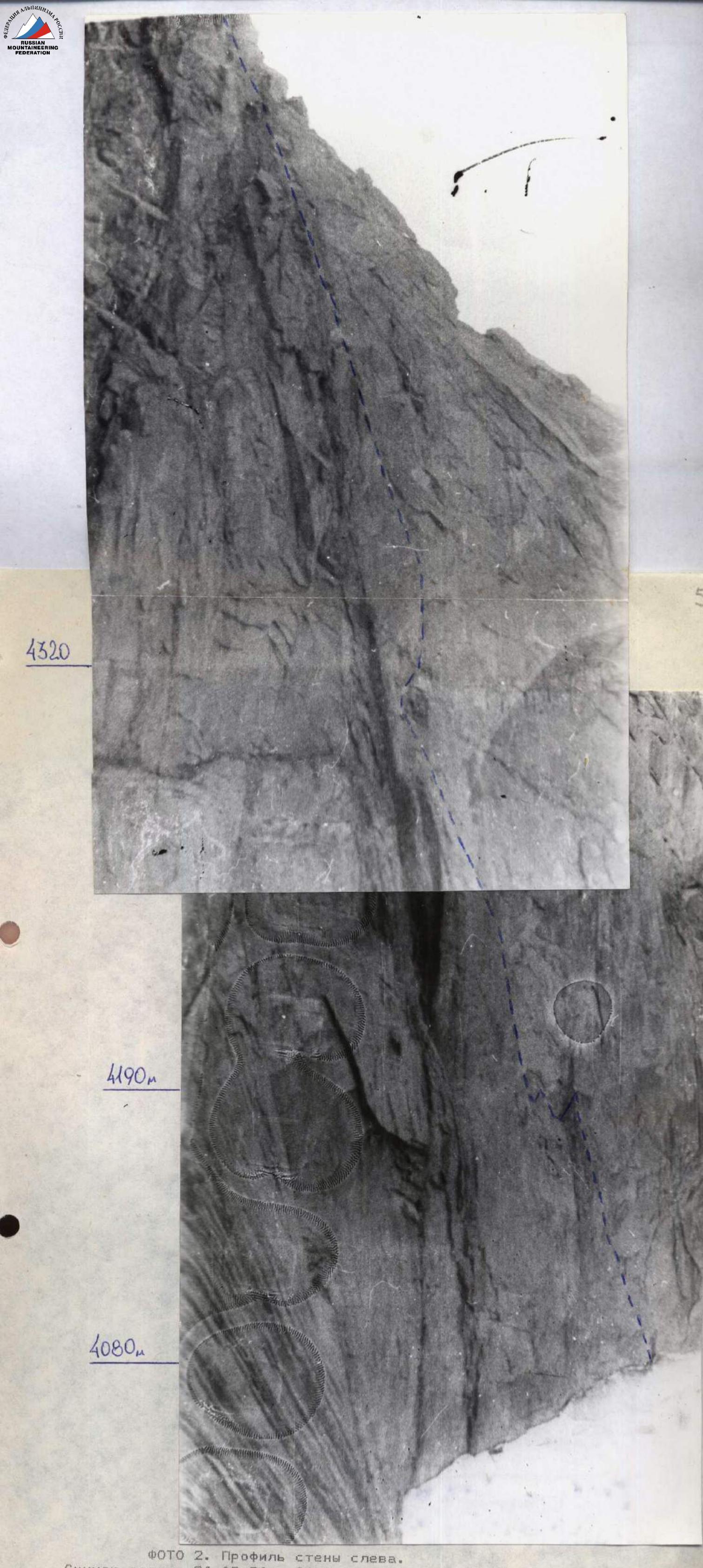
Photo 2. Profile of the wall on the left. The photo was taken on August 24, 1994. Lens “Helios-44M-4”, distance — 1200 m, height — 4000 m.
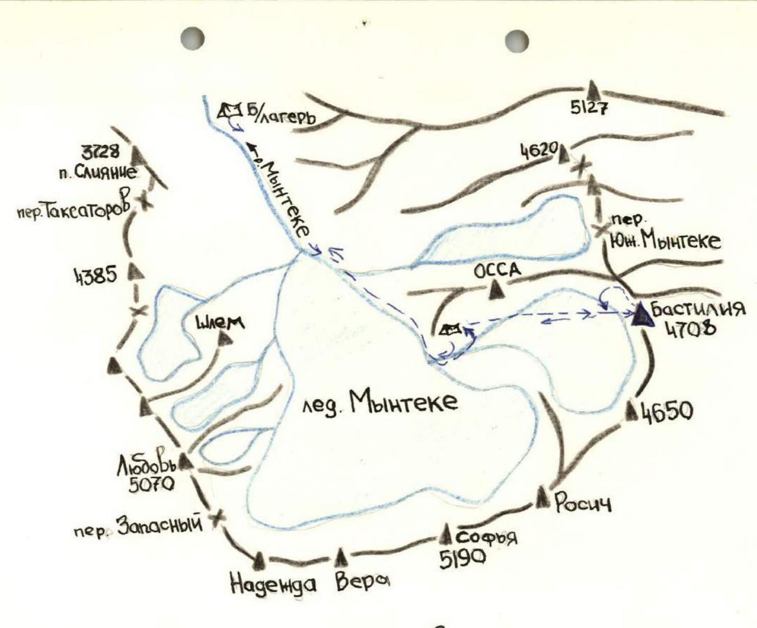
Map of the climbing area
Brief overview of the climbing area
From the Turkestan Range, separating the Dzhiptyk and Karatura gorges, a high massive mountain chain stretches to the northwest, conditionally called the Minteke Ridge. Located in this ridge, Peak 4708 m divides with its sheer wall the right tributary of the Shchurovsky Glacier and the Minteke Glacier. Peak 4708 m is a powerful rocky bastion, stretching from p. 4600 m to p. 5070 m, with a length of more than 2.5 km, resembling a horseshoe, at the foot of which the left tributary of the Minteke Glacier originates. The rocky bastion consists of granites and siliceous schists. The Minteke gorge is small in size and therefore the approaches to the routes do not take much time. The climate of the region is moderately continental. Administratively, the peak is located in the Batken district of the Osh region of Kyrgyzstan.
The approach to Peak 4708 m from the base camp, located in the green zone 300 m from the end of the Minteke Glacier at an altitude of 3300 m, takes 2–3 hours. The climbing area can be reached from the Vorukh settlement (Tajikistan) by following by car along the Kshemysh River to the tributary of the Chegesly River and further along the Chegesly gorge to the dairy farm (20 km). Then by a pack trail through the Dzhiptyk Pass to the meteorological station house (22 km). Further on the right side of the Dzhiptyk River downstream to the bridge. From it, the trail steeply winds up and then traverses to the right slope, smoothly leading to the Kugandy Pass. From it, a view opens up on the Minteke and Karatura gorges. From the Kugandy Pass, the trail, gradually gaining height, leads to the beginning of the Minteke Glacier. 300 m before the foot of the glacier, it is convenient to set up a camp in the green zone. From the meteorological station house to the base camp is about 30 km.
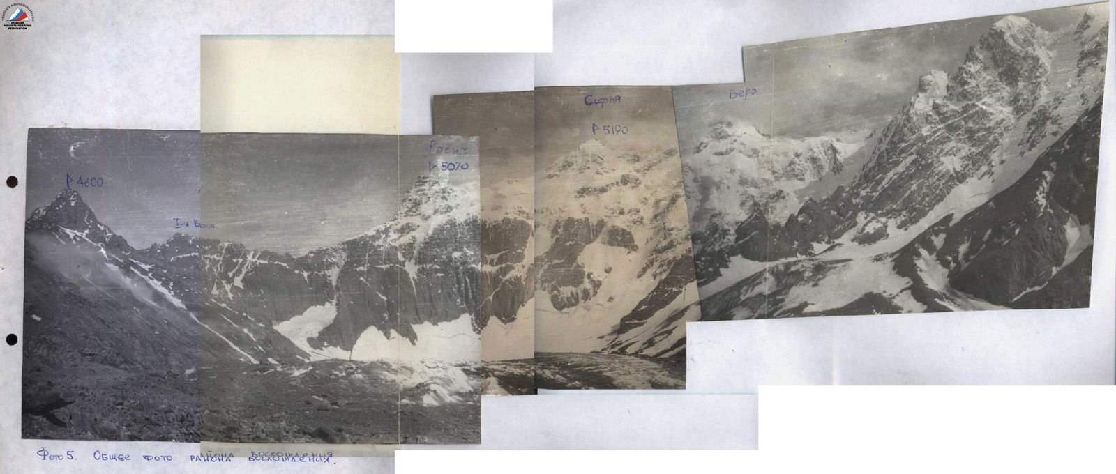
Photo 5. General photo of ascents
 www.alpfederation.ru↗
Tactical actions of the team
The team's tactical plan was designed to climb the right part of the NW wall “pillar” of Peak 4708 m (Bastille) according to two options, depending on weather conditions. The main option envisaged a two-day processing (passing a 30-meter overhang, two pendulums, and overcoming a hanging inner corner with an exit to the wall). The processing was carried out by two pairs: Kiriyenksiy — Mineev and Lapko — Kiriyenksiy. In two days, 5 ropes were processed. A 5th rope was taken on the route, which was planned to be used for rappel loops during descent. When entering the route, the leading pair worked according to the tactical plan. The first participant on the route worked on a double rope (one rope UIAA) in climbing shoes (alpinist version) from the “PNASI” company with a full set of climbing equipment (friends, nuts of 2 types, rock pitons, bolt pitons, skyhooks). The rest moved with top rope on jumars along the fixed ropes, the last participant worked with a lightened backpack. On the route, 4 pendulums were used, they were tactically discussed and practiced on the ground, taking into account safe passage and straightening of the fixed ropes after passage (the second participant straightened the fixed ropes without a backpack).
During processing, the pair started moving from 14:00 to 19:00. The fixed ropes were divided into reliable elements of protection at 3–4 points. The change of the lead climber during processing and ascent was made during the day after a light snack. The route was completely dry, so 8.5 l of water were taken. Food was prepared in an autoclave from high-calorie sublimated products in 5–10 minutes.
The lack of good ledges for overnight stays forced the team to use hammocks. The hammock was separately secured, and each participant was tied to the fixed ropes. The overnight stay was safe under an overhang. There were no falls or injuries.
The route allows the use of all samples of climbing equipment, but mostly medium-sized nuts were used.
The team was observed from the assault camp through binoculars by N. Arzamastsev, with whom communication was carried out according to the schedule specified in the route sheet. A log of observations and radio communications was kept.
Description of the route by sections
Approach to the route from the assault camp along the glacier to a horizontal slab lying under the wall. From it to the right along the wall about 50 m to a 3-meter slab.
- R0–R1. Up the slab 3 m, then along the flakes to the inner corner. Climbing is free (nuts, medium pitons). Along the right part of the corner using artificial aids (ITO).
- R1–R2. Straight up along the inner corner to a cornice. The corner overhangs. Free climbing alternates with the use of ITO (medium and large nuts, medium pitons, boxes).
- R2–R3. Up along the inner corner under a large cornice. Pendulum to the left onto an inclined slab, along it along a crack to the left up by free climbing to a cornice. Pendulum through a small cornice to the left onto an inclined slab (6 m). Further to the left 10 m to the base of the inner corner. At the belay station, a bolt piton is hammered, on it in a can 1 control knot.
- R3–R4. Up along the left edge of the inner corner, almost no relief, ITO (2 bolt pitons, 2 skyhooks, mostly pitons, nuts).
- R4–R5. Straight up along the left side of the inner corner using ITO to an overhang. Then to the left a pendulum — 5 m to the beginning of a flake.
- R5–R6. Up along a monolithic slab 15 m. Then a pendulum to the left 8 m to the beginning of an indistinct crack and along it up to the beginning of a large inner corner.
- R6–R7. Up along an inclined 10-meter slab on friction to the beginning of a corner. Along it to the right up by free climbing to a small slab. Overnight stay in hammocks. Straight up goes a vertical monolithic corner with a minimum of holds. 2nd control knot.
- R7–R8. Along the left part of the inner corner, alternating free climbing and ITO, under a cornice (pitons, nuts).
- R8–R9. The cornice is passed by free climbing. A wide crack begins (30–40 cm). Steep, climbing is free in an off-width to a small wall with a ledge. At the belay station 2 bolt pitons.
- R9–R10. The crack widens. Along the left side using ITO.
- R10–R11. The crack is blocked at the top by a cornice. Completely climbing on ITO (2 bolt pitons, 3 holes). The cornice is passed in the center using ITO.
- R12–R13. Straight up — a wide vertical inner corner. Along the left side mostly by free climbing (pitons, medium nuts).
- R13–R14. Up along the corner by free climbing under a 20-meter smooth wall leading to a ridge.
- R14–R15. Smooth wall with good holds. Climbing is free (medium nuts). Steep, belay station is hanging.
- R15–R16. To the left up along a slab along alternating cracks to a ridge. 3rd control knot.
- R16–R17. Along a sharp steep ridge to the summit.
- R17–R18. To the right 3 m up along a crack to the summit.
- R18. Summit!!!
| Rock | Nuts | Bolt pitons | R–R | Length, m | Steepness, ° | Category of difficulty | |
|---|---|---|---|---|---|---|---|
| 128/56 | 125/46 | 7+2* / 7+2* | P. 4708 m «Bastille» | ||||
| - | 6 | 2+1* | R18–R19 | 20 | 40 | 3 | |
| - | 10 | - | R17–R18 | 40 | 60 | 5 | |
| - | 6 | - | R16–R17 | 40 | 30 | 4 | |
| 5/1 | 8/1 | - | R15–R16 | 35 | 70 | 6 | |
| 6/2 | 9/3 | - | R14–R15 | 40 | 75 | 6 | |
| 4/2 | 9/3 | - | R13–R14 | 30 | 80 | 6 | |
| 8/3 | 6/2 | - | R12–R13 | 30 | 85 | 6 | |
| 10/1 | 7/4 | 2+1* | R11–R12 | 30 | 90 | 6 | |
| 9/3 | 7/4 | - | R10–R11 | 30 | 85 | 6 | |
| 6/2 | 6/3 | 2+1* | Processing 27.07.94 | ||||
| 9/3 | 8/3 | - | 17:00–19:00 | ||||
| 7/1 | 43 | 3+1* | Processing 28.07.94 | ||||
| 18/1 | 5/2 | - | 8:00 | ||||
| 7/2 | 5/1 | - | R9–R10 | 40 | 80 | 6 | |
| 15/1 | 4/2 | 1+1* | R8–R9 | 40 | 95 | 6 | |
| 11/1 | 3/2 | 2+1* | Processing 26.07.94 | ||||
| 7/21 | 2/21 | 1+1* | 19:00 | ||||
| 3 | 4 | - | R7–R8 | 40 | 80 | 6 | |
| 7/4 | 14/19 | - | R6–R7 | 40 | 85 | 6 | |
| 4/1 | 8/3 | - | R5–R6 | 40 | 90 | 6 | |
| 1 | 2 | 3 | R4–R5 | 35 | 85 | 6 | |
| R3–R4 | 30 | 80 | 6 | ||||
| R2–R3 | 30 | 70 | 6 | ||||
| R1–R2 | 40 | 95 | 6 | ||||
| R0–R1 | 40 | 80 | 6 |
Photo 6. Technical photo of the route
Photo 7. Section R2. Overcoming a 30-meter overhang. The entire route is clearly visible.

Photo 8. Passing the second pendulum before the 1st control knot.  Section R3.
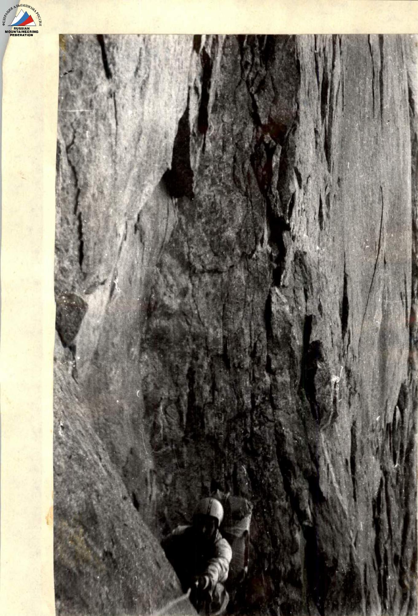
Photo 11. Section R5. Exit from the corner.

Photo 12. Section R6. 
Photo 21. Section R11. Wide crack.
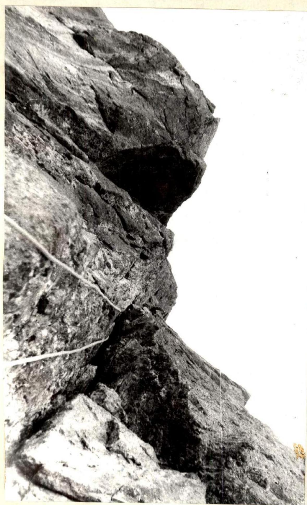
Photo 22. Section R12. The cornice is passed.