
I
Climbing Passport
- Type of ascent — first ascent
- Climbing area — Pamir-Alay, Zeravshan Ridge
- Peak — Tutek-peak (5435 m) via SE bastion of the wall
- Proposed difficulty category — 6B (first ascent)
- Height difference — 2200 m
including:
- Bastion — 1480 m
- Length — 5557 m
- Length of sections with 5–6 difficulty category — 1877 m (3300–3800, 3820–4300, 4330–4400, 4420–4770, 4960–5140)
Length of sections with 6 difficulty category — 758 m Average steepness of the Eastern subpeak — 67° (main part — 1950 m) including:
- Bastion — 71° (main part — 1450 m)
including:
- Lower cornice belt — 78° (main part — 500 m)
- Upper cornice belt — 74° (main part — 350 m)
- Number of pitons used:
| Type of pitons | Driven | Used |
|---|---|---|
| Rock | 227 | 28 |
| Chocks | 255 | 40 |
| Ice | 24 | 2 |
| Bolt | 4 | 2 |
| Skyhooks | 0 | 14 |
- Team's total hours — 70.5 (7 days — ascent)
- Overnights: 1–2 — semi-sitting in tents, separate: all nights on 3–6 — lying in tents on artificial platforms
- Team UА ВС DSO trade unions — АUSB «Varzob»
- Team leader — Glushko Vyacheslav Ivanovich — MS
Team members:
- Odintsov Alexander Nikolayevich — MS
- Rusyaev Alexey Vasilyevich — MS
- Arsentyev Sergey Anatolyevich — CMS
- Zakharov Vadim Vadimovich — CMS
- Mozhaev Mikhail Vasilyevich — CMS
- Skripko Vyacheslav Vitalyevich — CMS
- Soldatov Sergey Yuryevich — CMS
- Team coach — USSR MS Glushko Vyacheslav Ivanovich
- Departure to the route — July 19, 1986
Summit — July 25, 1986. Descent — July 26, 1986.
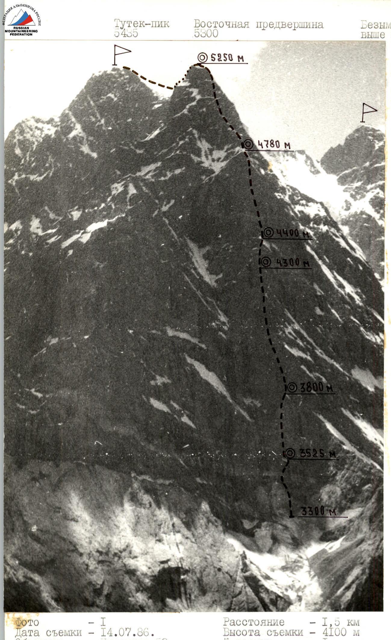
| Date taken | July 14, 1986 |
|---|---|
| Lens | Industar-32 |
| Distance | 1.5 km |
| Height | 4100 m |
| Shot # | 1 |
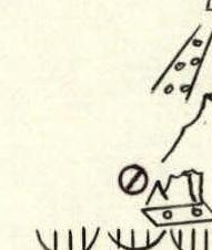
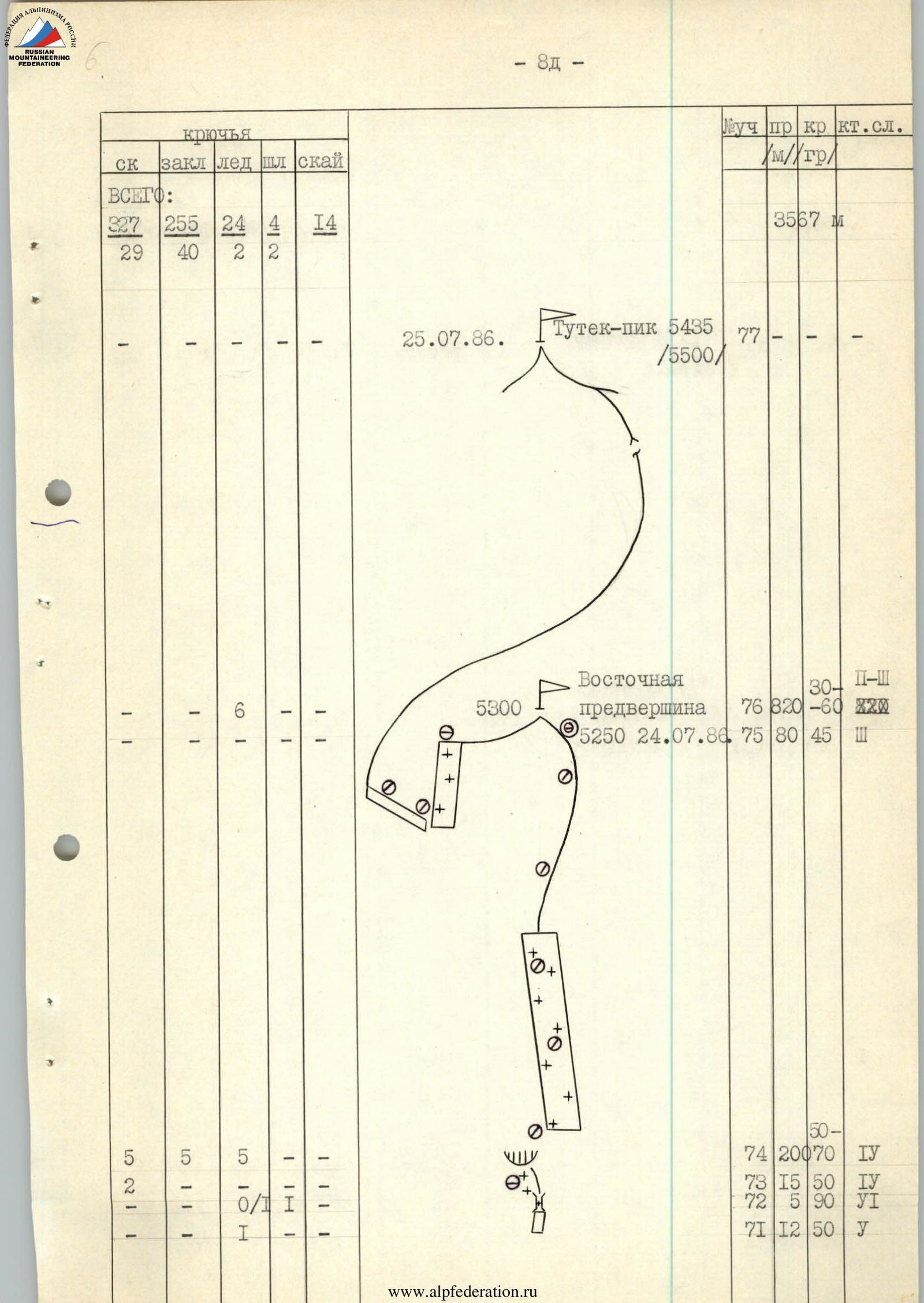
— Route of the first ascent by the team UА ВС DSO trade unions — АUSB «Varzob» on Tutek-peak (5435 m) via SE bastion of the wall, category 6B. (V. Glushko — 1986)
Brief overview of the climbing area
Tutek-peak is located in the southern spur of the Zeravshan Ridge (in close proximity to it), with an elevation of 5435 m on state maps. The eastern walls of the peak face the upper reaches of the Daari-Vandzhirud river, and the western walls face the Gorigh gorge. The Daari-Vandzhirud gorge can be accessed:
- by helicopter;
- through a pass (from Staraia Matcha through the Zeravshan Ridge);
- through the Dubursa gorges (through a lateral spur). The lower part is constrained by an impassable canyon. The river is fed by several glaciers, the largest of which is the Tutek glacier, approximately 5 km long. In the upper reaches of the cirque are peaks above 5000 m.
The microclimate of the gorge is characterized by high humidity and low winds (in the valleys). There is lush vegetation, with grass often exceeding human height. The Tutek glacier descends into a grove where:
- alder
- willow trees grow The path from Dubursa leads through thickets of jugan, which can be hazardous to traverse. The most stable good weather is typically observed in the second half of July and August.
Tutek-peak is one of the dominant peaks in the area, rising 2.5 km above the valley and is often shrouded in clouds.
The area is promising for alpinism but is difficult to access. The fact that it was discovered relatively late can be attributed to its location at the intersection of four state map sheets.
The most challenging routes pass through the Southeast wall of Tutek-peak, where the height difference is 2–2.5 km. The wall is characterized by several rock belts with a height difference of up to 500 m each and steepness up to 80°. The walls with a southwest orientation are rocky, while those with a northeast and north orientation are snowy and icy. There are no easy descent routes from the peak. As a climbing object, Tutek-peak was recommended by the famous Tajik alpinist Lavrushin V.Ya., who also took the first photographs and helicopter measurements of the absolute elevations. They were:
- summit — 5500 m;
- base of the wall — 3000 m.
According to helicopter reconnaissance by A. Odintsov (1986), the following absolute elevations were obtained:
- base camp — 2800 m;
- base of the wall — 3000 m;
- cirque — 3300 m;
- top of the bastion — 4780 m;
- Eastern subpeak — 5300 m;
- summit — 5500 m.
The total height difference was 2200 m.
Geologically, the area is a macrostructure consisting of recrystallized metamorphic formations, cut through by intrusions such as dykes. The Tutek-peak massif is such an intrusive body, composed of igneous rocks of acidic composition:
- granitoids;
- granodiorites, whose fine-crystalline structure determines the monolithic character of the main wall of the bastion. In the upper part of the massif, argillite schists are noted, whose tile-like structure greatly complicates climbing and belay organization.
The nearest major administrative center is the settlement of Garm in the Tajik SSR, through whose airport many local airlines pass. From Garm to the village of Sia-Dzhanal («New») in the Sarbog gorge leads a 50 km long road.
In the village, one needs to:
- cross the bridge to the left bank of the Sarbog river;
- ascend to the bridge over the Dubursa river (1 hour 30 minutes walk). Then follow the trail through the 3720 m pass, which leads to the Daari-Vandzhirud gorge. From the bridge to the base camp under Tutek-peak — 13 hours walk. To transport cargo, one can hire donkeys in the upper villages.
UIAA route diagram
M 1:2000
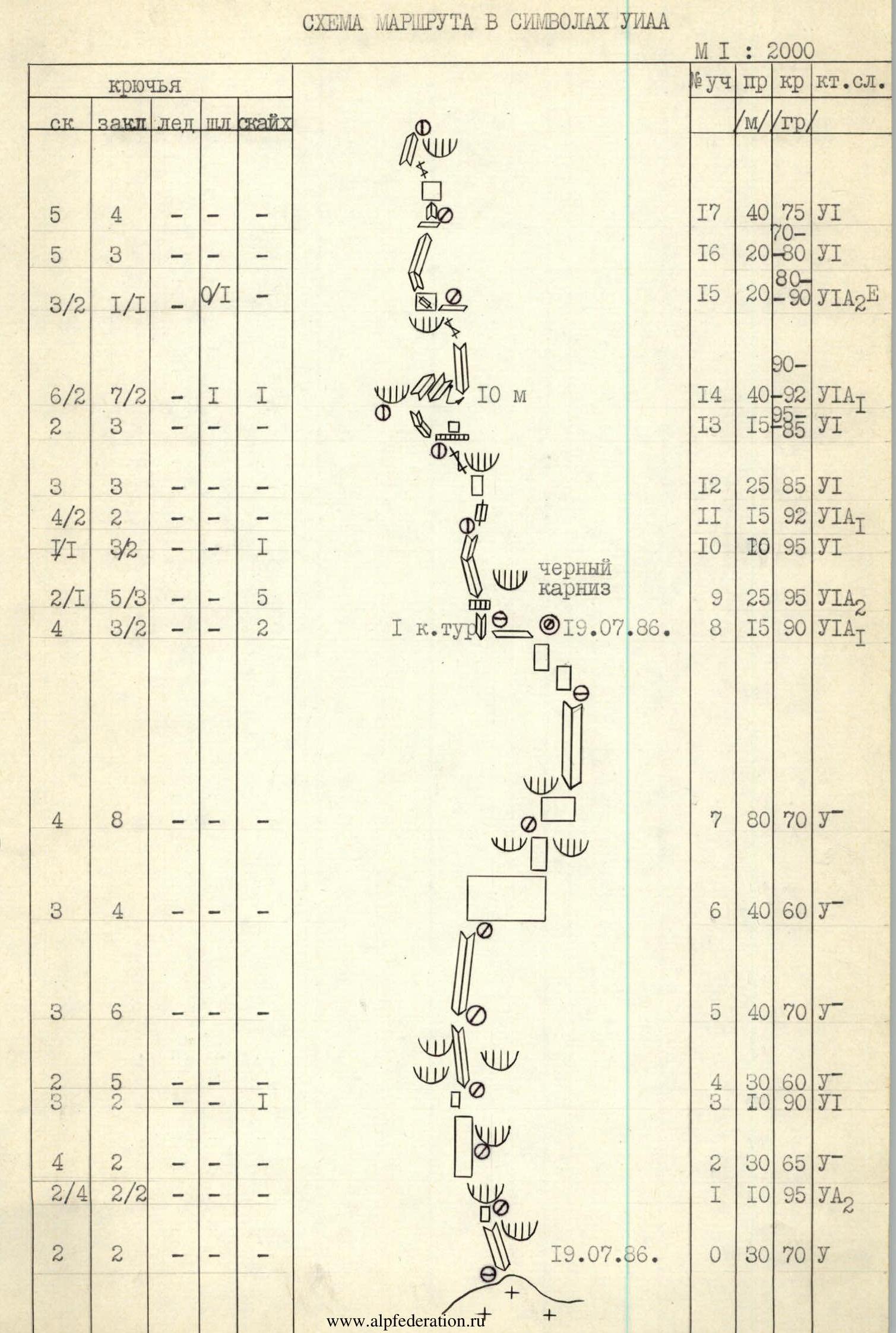
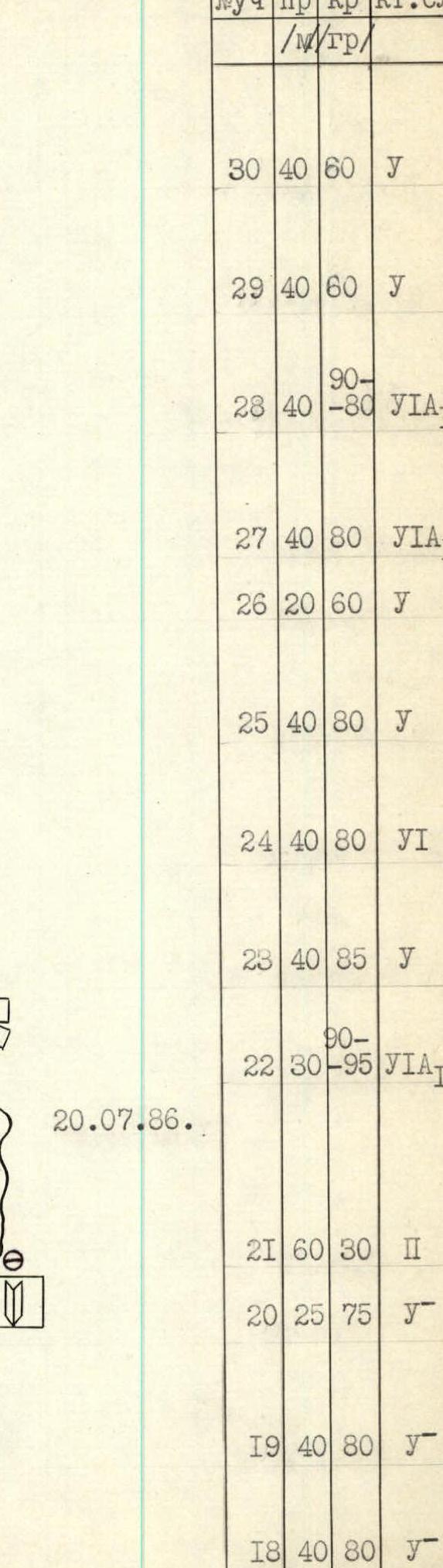
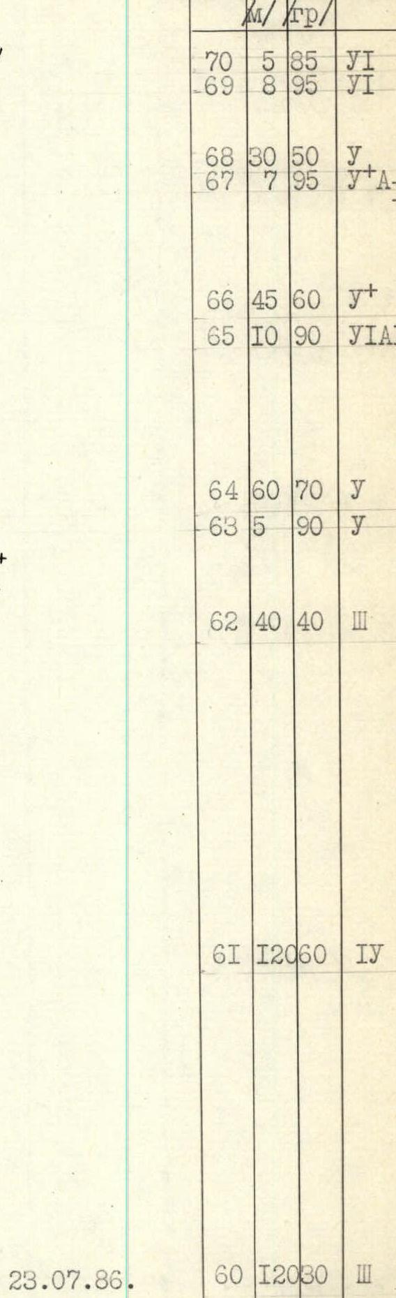
| Section # | Length (m) | Steepness (°) | Difficulty category | Date | Notes |
|---|---|---|---|---|---|
| R0 | 30 | 70 | 1Б | ||
| R1 | 10 | 95 | 2А | ||
| R2 | 30 | 65 | 2Б | ||
| R3 | 10 | 90 | 3А | ||
| R4 | 30 | 60 | 2Б | ||
| R5 | 40 | 70 | 1Б | ||
| R6 | 40 | 60 | 1Б | ||
| R7 | 80 | 70 | 1Б | ||
| R8 | 15 | 90 | 1А | July 19, 1986 | 1st control point |
| R9 | 35 | 95 | 2А | ||
| R10 | 10 | 95 | 1Б | ||
| R11 | 15 | 92 | 1А | ||
| R12 | 25 | 85 | 1Б | ||
| R13 | 15 | 95 | 1Б | black cornice | |
| R14 | 40 | 92 | 1А | 10 m | |
| R15 | 20 | 90 | 1Б | ||
| R16 | 20 | 80 | 1Б | ||
| R17 | 40 | 75 | 1Б | ||
| R18 | 40 | 80 | 1Б | ||
| R19 | 40 | 80 | 1Б | ||
| R20 | 25 | 75 | 1Б | ||
| R21 | 60 | 30 | 2Б | July 20, 1986 | |
| R22 | 30 | 95 | 1А | ||
| R23 | 40 | 85 | 1Б | ||
| R24 | 40 | 80 | 1Б | ||
| R25 | 40 | 80 | 1Б | ||
| R26 | 20 | 60 | 4 | ||
| R27 | 40 | 80 | 1А | ||
| R28 | 40 | 80 | 1А | ||
| R29 | 40 | 60 | 1Б | ||
| R30 | 40 | 60 | 1Б | ||
| R31 | 30 | 70 | 1Б | ||
| R32 | 30 | 60 | 1Б | ||
| R33 | 30 | 70 | 1Б | ||
| R34 | 30 | 50 | 1Б | ||
| R35 | 40 | 70 | 5Б | ||
| R36 | 40 | 80 | 1Б | ||
| R37 | 30 | 60 | 1Б | ||
| R38 | 30 | 60 | 1Б | ||
| R39 | 10 | 90 | 1Б | ||
| R40 | 10 | 20 | 2Б | July 21, 1986 | |
| R41 | 40 | 60 | 3Б | ||
| R42 | 20 | 60 | 2А | ||
| R43 | 40 | 60 | 1Б | ||
| R44 | 40 | 75 | 1Б | ||
| R45 | 20 | 50 | 1Б | ||
| R46 | 40 | 60 | 1Б | ||
| R47 | 45 | 30 | 2Б | July 22, 1986 | |
| R48 | 45 | 85 | 6Б | 5 m | |
| R49 | 45 | 80 | 6Б | 10 m | |
| R50 | 45 | 90 | 6Б | ||
| R51 | 45 | 85 | 6А | ||
| R52 | 40 | 70 | 1А | ||
| R53 | 40 | 70 | 1Б | ||
| R54 | 35 | 65 | 1Б | ||
| R55 | 35 | 70 | 1Б | ||
| R56 | 5 | 95 | 2А | ||
| R57 | 40 | 65 | 1Б | ||
| R58 | 80 | 60 | 4Б | ||
| R59 | 50 | 40 | 3Б | ||
| R60 | 120 | 30 | 3Б | July 23, 1986 | |
| R61 | 120 | 60 | 4Б | ||
| R62 | 40 | 40 | 3Б | ||
| R63 | 5 | 90 | 5 | ||
| R64 | 60 | 70 | 5 | ||
| R65 | 10 | 90 | 6А | ||
| R66 | 45 | 60 | 4Б | ||
| R67 | 7 | 95 | 5Б | ||
| R68 | 30 | 50 | 3Б | ||
| R69 | 8 | 95 | 5Б | ||
| R70 | 5 | 85 | 1Б | ||
| R71 | 17 | 50 | 5Б | ||
| R72 | 5 | 90 | 5Б | ||
| R73 | 15 | 50 | 4Б | ||
| R74 | 80 | 50 | 4Б | ||
| R75 | 80 | 45 | 3Б | ||
| R76 | 820 | 30 | 3Б | July 24, 1986 | |
| R77 | July 25, 1986 | Tutek-peak (5500 m) |
| Pitons | RK | CHOK | ICE | BOLT | SKYH | | :----: | :-: | :---: | :-: | :--: | | | | | | | | | | | | | | 2 | 5 | - | - | - | | 7 | 1 | - | - | - | | 3/2 | 3/1 | - | - | 1 | | 5/1 | 4/2 | - | - | - | | 2 | 3 | - | - | - | | 3 | 7 | - | 1 | - | | 4 | 7 | - | - | - | | 2 | 6 | - | - | - |
| 4/2 | 4/4 | - | 1 | 1 |
|---|---|---|---|---|
| 2 | 2 | - | - | - |
| 4 | 5 | - | - | - |
| 8 | 2 | - | - | - |

| Pitons | RK | CHOK | ICE | BOLT | SKYH | | :----: | :-: | :---: | :-: | :--: | | 2 | 8 | - | - | - | | 1 | 4 | - | - | - | | 9 | 3 | - | - | - | | 3 | 2 | - | - | - | | 1/1 | 2/2 | - | - | - | | 6 | 2 | - | - | - | | 13 | 1 | 1 | - | - | | 2 | 4 | - | - | - | | 2 | 6 | - | - | - | | 3 | 7 | - | - | - | | 3 | 5 | - | - | - | | 6 | 5 | - | - | - | | 4 | 5 | - | - | - | | 2 | 4 | - | - | - | | 3 | 6 | - | - | - |
| Pitons | RK | CHOK | ICE | BOLT | SKYH | | :----: | :-: | :---: | :-: | :--: | | 1 | 3 | 1 | - | - | | 3 | 3 | - | - | - | | 5 | 4 | - | - | - | | 0/3 | 0/2 | - | - | - | | 2 | 4/2 | - | - | - | | 6 | 7 | - | - | - | | 3 | 3 | - | - | - | | 2/1 | 3/3 | - | - | - | | 4/2 | 6/3 | - | - | - | | 7 | 8 | - | - | - | | 2/3 | 5/2 | - | 0/1 | - |

| Pitons | RK | CHOK | ICE | BOLT | SKYH | | :----: | :-: | :---: | :-: | :--: | | 1 | 1 | 1 | - | - | | 3 | 2/2 | - | - | - | | 4 | 2 | 2 | - | - | | 4 | 2/1 | - | - | - | | 3 | 2 | 1 | - | 2 | | 1/1 | 2/1 | - | - | - | | 4 | - | 4 | - | - | | - | 0/1 | - | - | - | | 2 | 1 | - | - | - | | 8 | 10 | - | - | - | | - | 4 | - | - | - |
Route description by sections
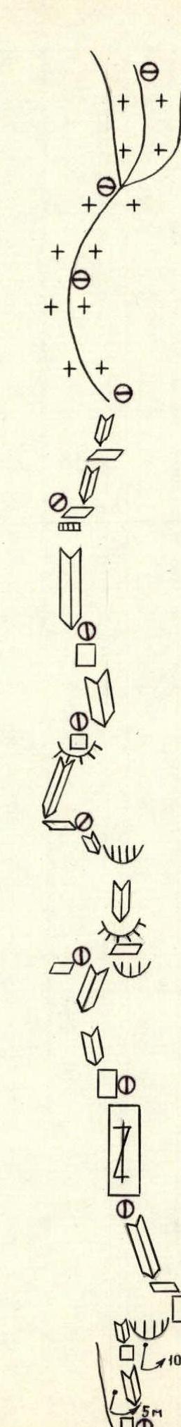
Section R0–R1. An indistinct internal angle in the central part of the cirque, directly under the "snow patch". Not prone to rockfall as it is sandwiched between cornices. 30 m, 70°, category 1Б.
Section R1–R2. Through destroyed rocks to an overhanging wall. Requires artificial aids. 10 m, 95°, category 2А.
Section R2–R3. Monolithic slab leading to black rocks. 30 m, 65°, category 2Б.
Section R3–R4. Vertical wall leading to an internal angle that goes left, bypassing the black rocks. 10 m, 90°, category 3А.
Section R4–R5. Internal angle protected by an overhanging rock on the right. 30 m, 60°, category 2Б.
Section R5–R6. Internal angle leading to the base of a light-colored slab. 40 m, 70°, category 1Б.
Section R6–R7. Steep slab with poor relief. Difficulties with belay organization. Move right to a visible passage in the cornice belt. 40 m, 60°, category 1Б.
Section R7–R8. Through a vertical wall to an internal angle (40 m) with smooth walls. Then move left to a ledge leading to a snow patch. Overnight here. 1st control point. 60 m, 70°, category 1Б.
Section R8–R9. Indistinct internal angle with an overhanging right part. Start from a snow patch. Rocks are monolithic, very difficult. Skyhooks are used. 15 m, 90°, category 1А.
Section R9–R11. Through a cornice with a 0.5 m overhang to an internal angle that goes left and up, bypassing a black cornice. The angle initially slopes, then becomes overhanging. Climbing is extremely difficult, on the verge of a fall. Most of the section is climbed by the first participant in a hang or counter-tension. 35 m, 95°, category 2А–1Б.
Section R11–R12. Overhanging crack on a smooth slab is passed using friends. Climbing is extremely difficult, straining the hands. 15 m, 92°, category 1Б.
Section R12–R13. Monolithic slab with minimal holds leads to a crack under the black cornice. Climbing is psychologically difficult, on friction. The crack is climbed free, with belay through chocks. Exit under the cornice. 25 m, 85°, category 2Б.
Section R13–R14. Monolithic cornice (0.3 m overhang, 1 m high) is climbed free, without artificial aids. Above the cornice, a difficult traverse left on a vertical wall to an internal angle. Climbing is extremely difficult, on the verge of a fall. 15 m, 95–85°, category 1А.
Section R14–R15. From under the cornice, ascend right and up a vertical internal angle without cracks (10 m). Then a pendulum — 10 m right to an overhanging internal angle. A bolt is used for the pendulum. The 30-meter internal angle is mostly climbed free (only two friends are used as artificial aids). 40 m, 90–92°, category 1А. Climbing is exceptionally difficult. From the angle, exit to a narrow ledge to the right of the overhang.
Section R15–R16. Move left on a vertical wall with a crack. Very difficult section. General direction left and up. 20 m, 80–90°, category 1Б.
Section R16–R17. External angle. Limited holds. Climbing is on the verge of a fall. 20 m, 70–80°, category 1Б.
Section R17–R18. Through an internal angle, wall, crack, and another internal angle, move straight up to the right part of a large external angle. Rocks are monolithic, holds are limited, passage is very difficult. 40 m, 75°, category 1Б.
Section R18–R20. Steep wall leads to an internal angle. Then, through a system of walls, ascend straight up to a narrow ledge. Rocks are steep but have good relief. 80 m, 80°, category 1Б.
Section R20–R21. Internal angle with good holds leads to a narrow rocky ledge with snow. This is the top of the lower cornice belt, appearing as the summit of the lower rocky triangle from below. Overnight here. 25 m, 75°, category 1Б.
Section R22–R23. Wall above two large flakes. Overhangs in the upper part. Rocks are monolithic, difficult to pass. 30 m, 90–95°, category 1Б.
Section R23–R26. Series of monolithic internal angles with smooth walls lead under a cornice with black streaks. Section is climbed free. 80 m, 85–80°, category 5Б.
Section R25–R26. Cornice is bypassed on a vertical gray slab with poor relief. Then move along a narrow ledge under the cornice to a yellow wall. 40 m, 80°, category 4.
Section R26–R27. Internal angle leading to the edge of the bastion. 20 m, 60°, category 4.
Section R27–R28. Steep destroyed rocks between two overhangs lead to the base of an internal angle. Climbing is very difficult and cautious. Difficult to organize belay. 40 m, 80°, category 1А.
Section R28–R29. Internal angle (overhanging in the upper part) through overhangs leads to a scree ledge under a flake. Very steep, much "live" rock, requires great caution. 40 m, 90–80°, category 1А.
Section R29–R30. Bypass the flake and start ascending a crack leading to the base of an inclined slab. Section is climbed free. 40 m, 60°, category 1Б.
Section R30–R31. Slab becomes almost vertical. Traverse left to a crack. Ascend the crack to the base of the next flake. 40 m, 60°, category 1Б.
Section R31–R32. From the flake, through an indistinct internal angle, exit to a smooth wall. Section is climbed free. 30 m, 70°, category 1Б.
Section R32–R33. Inclined slab and then an internal angle lead to a rocky ridge. Rocks are monolithic. 30 m, 60°, category 1Б.
Section R33–R34. Through a monolithic slab without cracks, exit to the ridge. 30 m, 70°, category 1Б.
Section R34–R35. Ascend the left part of a couloir, initially on a wall, then an internal angle, and again a wall. 30 m, 50°, category 3Б.
Section R35–R37. Series of indistinct internal angles and walls lead to the base of a couloir. Cracks are filled with ice. Very steep. Climbing is extremely difficult. 50 m, 90–70–30°, category 5Б.
Section R37–R39. Alternating internal angles and walls through two combs lead to a snow patch. Rocks are destroyed. 60 m, 60°, category 4Б. 10 m, 90°, category 1Б. Possible overnight spot.
Section R40–R42. Through destroyed rocks, move left under cornices. 50 m, 20–70°, category 3Б.
Section R42–R43. Smooth internal angle through an overhang leads to a horizontal ledge. Cracks are filled with ice. Climbing is on the verge of a fall. 20 m, 80–60°, category 2А.
Section R43–R44. Through walls, approach a small overhang, which is climbed "head-on". 40 m, 60°, category 1Б.
Section R44–R45. Destroyed slab leads to the base of an internal angle. 40 m, 75°, category 1Б.
Section R45–R47. Internal angles, fairly destroyed, lead to the base of the upper cornice belt. 60 m, 50°, category 1Б–1Б. Overnight spot. 2nd control point.
Section R47–R48. Steep ledge under the base of the upper cornice belt. Move right to an overhanging rocky rib.
Section R48–R49. Ascend the rib (10 m), then move right to a wall with ice. Ascend 10 m up the wall under a cornice. Then a pendulum — 3 m right to an internal angle. Ascend 8 m on artificial aids, then a pendulum — 10 m right to a vertical wall. The last pendulum is done on a bolt. Ascend 7 m up the wall. Rocks are icy, cracks are filled with ice. Climbing is extremely difficult. 45 m, 85°, category 6Б.
Section R49–R50. Vertical wall leads to an internal angle. Cracks are filled with ice. Section is very difficult both to climb and to belay. 45 m, 60°, category 6Б.
Section R50–R51. Crack on a vertical wall. Climbed free. The wall above the crack is climbed with artificial aids. Rocks are covered with ice, extremely difficult to pass. 45 m, 85–90°, category 6А.
Section R51–R52. Internal angle with a crack in the center. Move left and up, bypassing a black overhang. Almost everywhere, there is ice on the rocks. Starting from section R48 and up to the summit, climbing is done in crampons. Very difficult.
Section R52–R53. Through an icy "bald forehead" enter a snowy internal angle. Overhang is bypassed on the left. Almost all holds are covered with ice. Very difficult movement on balance. 40 m, 70°, category 1А.
Section R53–R54. Destroyed internal angle with ice leads to a "bald forehead". 40 m, 70°, category 1Б.
Section R54–R56. Internal angles with smooth walls. Covered with ice. Relief is almost absent. Passage is on balance, on the verge of a fall. 70 m, 65–70°, category 2Б.
Section R56–R57. Cornice, uniformly overhanging over a 5-meter section. Climbed on artificial aids, in the center, through a narrow crack. 5 m, 95°, category 2А.
Section R57–R58. Snowy internal angles leading to a ridge. 40 m, 65°, category 4Б.
Section R58–R60. Rocky, steep, monolithic, and snowy ridge. 60 m, 60°, category 4Б.
Enter the bastion summit. 50 m, 40°, category 3Б.
Section R60–R61. Snowy ridge with cornices leading to the base of the Eastern subpeak tower. 120 m, 30°, category 3Б.
Section R61–R62. Movement through internal angles on snowy rocks. 120 m, 60°, category 4Б.
Section R62–R63. Snowy edge. 40 m, 40°, category 3Б.
Section R63–R64. Vertical chimney filled with ice. 5 m, 90°, category 5.
Section R64–R65. Slab covered with a thick layer of ice and snow on top. Climbed in crampons. 60 m, 70°, category 5.
Section R65–R66. Vertical wall. Holds are covered with ice and snow on top. Climbing is difficult. 10 m, 90°, category 6А.
Section R66–R67. Wall with a cornice in the middle. Cornice is passed through a crack on artificial aids. Wall is snowy, cracks are filled with ice. 40 m, 60°, category 4Б.
Section R67–R68. Uniformly overhanging slab. Passed through a crack on
Comments
Sign in to leave a comment