Passport
I. Technical class 2. Pamir-Alay, Zeravshan ridge 3. Akhun peak (5224 m) via the right counterfort of the Southeast wall 4. Proposed 6B category of difficulty, first ascent 5. Elevation gain 1734 m, length 1892 m. Length of sections with 5–6 category of difficulty — 1752 m. Of which 6 category of difficulty — 829 m.
Average steepness:
- main part of the route — 82.5°
- route overall — 76°
- Use of belay points:
| rock pitons | bolt pitons | ice screws | chocks |
|---|---|---|---|
| 170 | 1 | 36 | 247 |
| 19 | 1 | 0 | 30 |
-
Team's climbing hours 52.5 h and days — 5
-
Overnights: 1st on a rock-snow ledge for 6 people, 3940 m. 2nd on a rock-snow ledge for 6 people, 4320 m. 3rd night — at the second location (bad weather day). 4th snow-constructed bivouac for 6 people, 4730 m.
-
Climbing qualification and rock climbing
Team leader Arkhipov V.A. MS CMS
Participants:
- Kokhanov V.N. MS MS
- Kuznetsov A.V. MS CMS
- Kolesnikov K.I. CMS CMS
- Mozharov N.N. CMS CMS
- Naumov N.L. CMS CMS
-
Coach: Sapozhnikov Yuri Georgievich
-
Departure to the route: July 12, 1988 Summit: July 16, 1988 Return: July 17, 1988
-
Organization: Krasnoyarsk Kraysportkomitet
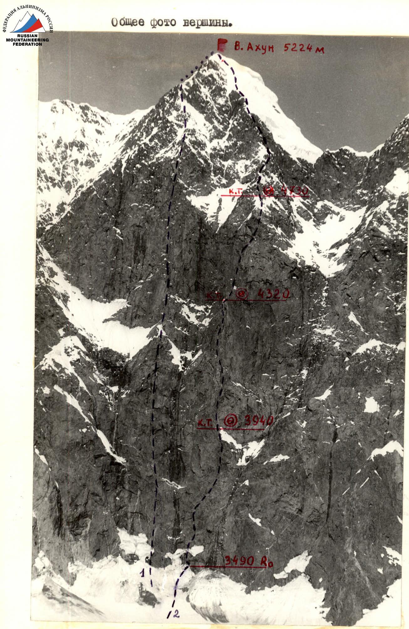
Date taken: July 1, 1988. Lens: Nikor. Shooting point: # 1. Time taken: 12:00. F=50 mm. Distance ≈ 1.5 km. Height 3350 m.
- Fedotov's route
- Team's route
Photo of the wall profile from the left.
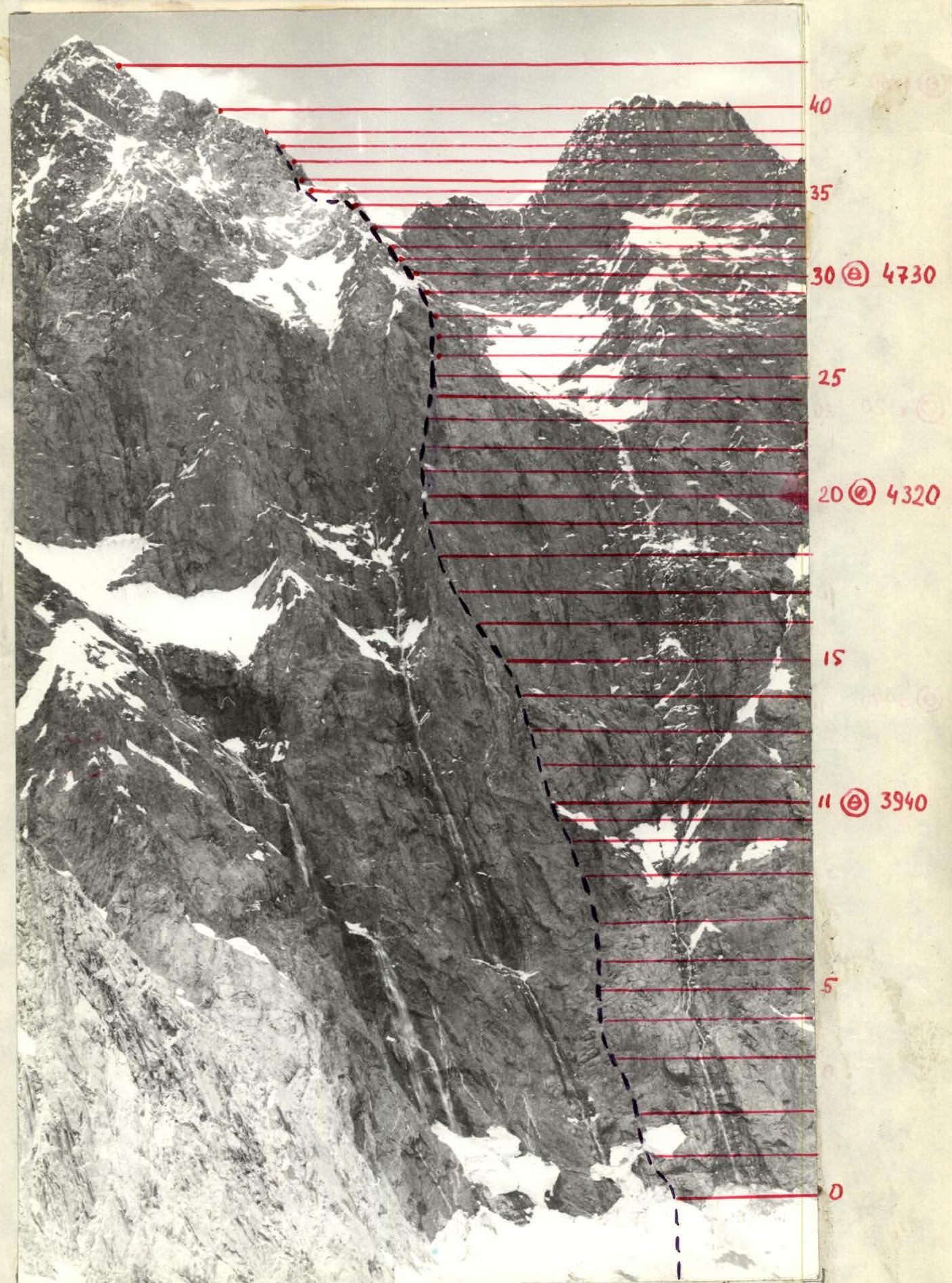
Date taken: July 3, 1988. Time taken: 12:00. Lens: Nikor F=50 mm. Distance ≈ 2 km. Shooting point: # 3. Height 3650 m.
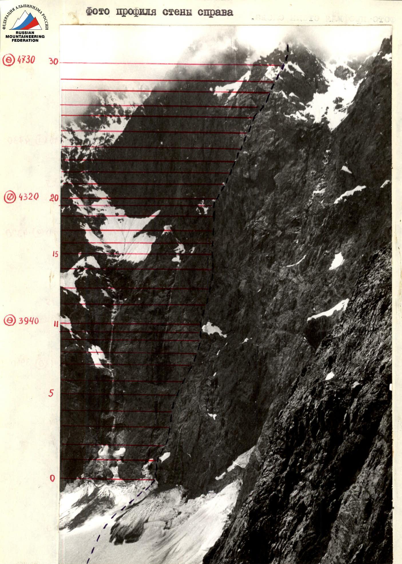
Date taken: July 12, 1988. Time taken: 12:00. Lens: Nikor F=50 mm. Distance ≈ 1 km. Shooting point: # 2. Height 3600 m.
Brief overview of the ascent area
Brief overview of the ascent area. A route of 6 category of difficulty was laid on the Akhun peak (5224) in 1980 by a group led by Fedotov (LenVO gatherings).
This area was visited by LenVO gatherings:
- in 1980 — ascent to Akhun peak;
- in 1982 — visit to the area;
- in 1983 — second passage of the 6 category of difficulty route through the center of the Southeast wall to Akhun peak by a group led by Ivashchenko A.
As can be seen from the data, the area is rarely visited by climbers.
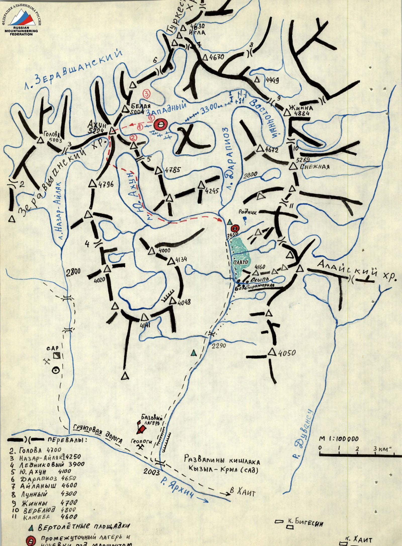
Approach to the ascent object
You can reach the object of ascent from Dushanbe (via the Dushanbe – Jirgital road) to the village of Khait, 260 km, by car. From the village of Khait along the dirt road through the Yarhich river valley to the Darai-Pioz river 30 km, by car. Here is the geologists' camp, where the car can reach, and the base camp was set up.
From the base camp to the intermediate camp:
- Distance: 15–18 km upstream along the Darai-Pioz valley
- Time: 7–8 h
- The trail follows the right (orographic) bank of the valley
- Cross to the left bank via a snow bridge 6–7 km below the glacier tongue
- Intermediate camp is located on the left (orographic) bank of the Darai-Pioz river, height 2650 m
- There is a spring, flat areas, and a green meadow
- Rest here is quite adequate
From the intermediate camp to the overnight stays on the moraine:
- Climb up the glacier, sticking to its right side along the way to the confluence of the East and West Darai-Pioz glaciers (2 h)
- Cross the glacier from right to left
- Continue climbing approximately in the middle of the West Darai-Pioz glacier
- The glacier is open, without crevasses
- Overnight stays are on the moraine outcrops under Akhun peak
- Time from the intermediate camp to the overnight stays on the moraine: 3.5 h
- Approach to the start of the route from the overnight stays: 1 h
Akhun peak is immediately recognizable, at first glance — a complete match to the photograph.
Features of the area
A feature of the area is highly unstable weather. The mountains in the area and are composed of schists, gray granites, basalt, and magmatites.
- schists
- gray granites
- basalt
- magmatites
The area is of high seismic activity.
A feature of the flora is an abundance of "vgan" grass, which causes severe chemical burns on exposed skin; on moist exposed skin (in rain) the burns are especially severe.
Preparation for the ascent
Preparation for the 1988 RSFSR championship began immediately after the 1987 USSR championship. During preparation, they adhered to the proven practice of preparation for the 1985-1987 USSR championships, when the team became the country champion.
Preparation included:
- Training in the gym three times a week;
- Saturday and Sunday — training on the Krasnoyarsk Stolby;
- Training on Stolby — climbing with top rope, climbing in pairs, and free climbing — provides physical, psychological, technical, and special preparation;
- Alternating training on Stolby with cross-country running and skiing (depending on the season);
- Once a month — control attempts;
- Mandatory participation in rock climbing competitions and "alpine triathlon".
Main stages of preparation:
- In April — passing fitness standards, all candidates showed high results;
- In VIZ, the results of excellent preparedness were confirmed;
- In November 1987 — s/k "Yenisei" held gatherings in a/l Dyugoba;
- In January 1988 — rehabilitation gathering, Caucasus, AUSB "Planeta";
- In February 1988 — UTS s/k "Yenisei" on Tian-Shan. Winter ascents of 3–5 category of difficulty were made;
- In May 1988 — participation in the regional alpinade, Tuva, working as instructors and making a first ascent of 5B category of difficulty approximately;
- In June — the duo Kokhanov – Kolesnikov as part of a group from s/k "Yenisei" made an ascent of 6B category of difficulty to peak Asan;
- In the Darai-Pioz valley, they made an ascent of 5B category of difficulty to peak 4160 as part of the "school" program with practice of the intended belay technique.
Choosing the object of ascent presented a certain difficulty. After evaluating the collected information, they settled on the peaks Sauk-Djaylyau and Akhun.
In favor of Akhun peak were:
- elevation gain
- steepness
- novelty of the proposed route
- underdeveloped area
The route to Akhun peak was assessed as the main one, meeting the requirements for routes participating in competitions of the highest rank.
Direct observation of the object on July 1, 2, 3, and 5, 6, 7 allowed for photo shooting and the creation of a tactical plan for the ascent, taking into account the specifics of the area and weather conditions. The wall profile is practically impossible to capture, as the wall forms a cirque, and supposedly more suitable shooting locations are obstructed.
After observing the route on July 11, they summarized the data. They also took into account the recommendations of the first ascenders to Akhun peak — interaction with LenVO gatherings, see the "Tactical actions of the team" section.
The essence of the recommendations:
- "The bottom is hit hard, possibly the top too.
- 'Six' is very serious, prepare well".
Problematic sections — the bottom of the wall, section R0–R3, where it hits (constantly confirmed during observation). On section R13–R19, three paths are visible. One of the keys is section R23–R28, consisting of a series of cornices. Safety on the route is ensured by working on a double rope. All (except the first) use top rope. UIAA ropes 60 m long are used, along with the entire arsenal of technical means.
Days of ascent without a backpack, on a double rope. Processed sections are traversed via perlines with additional bottom rope.
Presumably, the sections to be traversed should be passed before sunrise on the route.
The team has excellent material support, a wide range of technical means, and a first-aid kit with a large assortment of medicines.
For communication with observers and the rescue team, we use "Kaktus" radios, with communication according to the schedule.
A fully equipped rescue team is located in the intermediate camp.
The rescue team consists of:
- Tronin V., head of the rescue team
- Laptenok V., member of the rescue team
- Sapozhnikov Yu., member of the rescue team
- Marcenko Yu., member of the rescue team
- Egorov I., member of the rescue team
- Dyundik K., doctor
The rescue team has training ascents and the right to ascend to a route of 6 category of difficulty.
In the base camp, a "Kamaz" vehicle is constantly ready.
For the season, an improved version of the sauna was manufactured — a key element of the recovery center, significantly improving acclimatization.
The prepared and tested (in winter ascents of 1988) platform was not used, except for the tent from it.
Homemade equipment, tested more than once in "combat conditions", was thoroughly inspected and tested in laboratory conditions at the "Krasmash" factory before the season.
Tactical actions of the team
Tactical actions of the team:
- Were carried out in accordance with the tactical plan, which was fully implemented during the ascent, with no deviations.
- Organization of rope team movement, their interaction, and leader changes were conducted according to the tactical plan.
Safety organization:
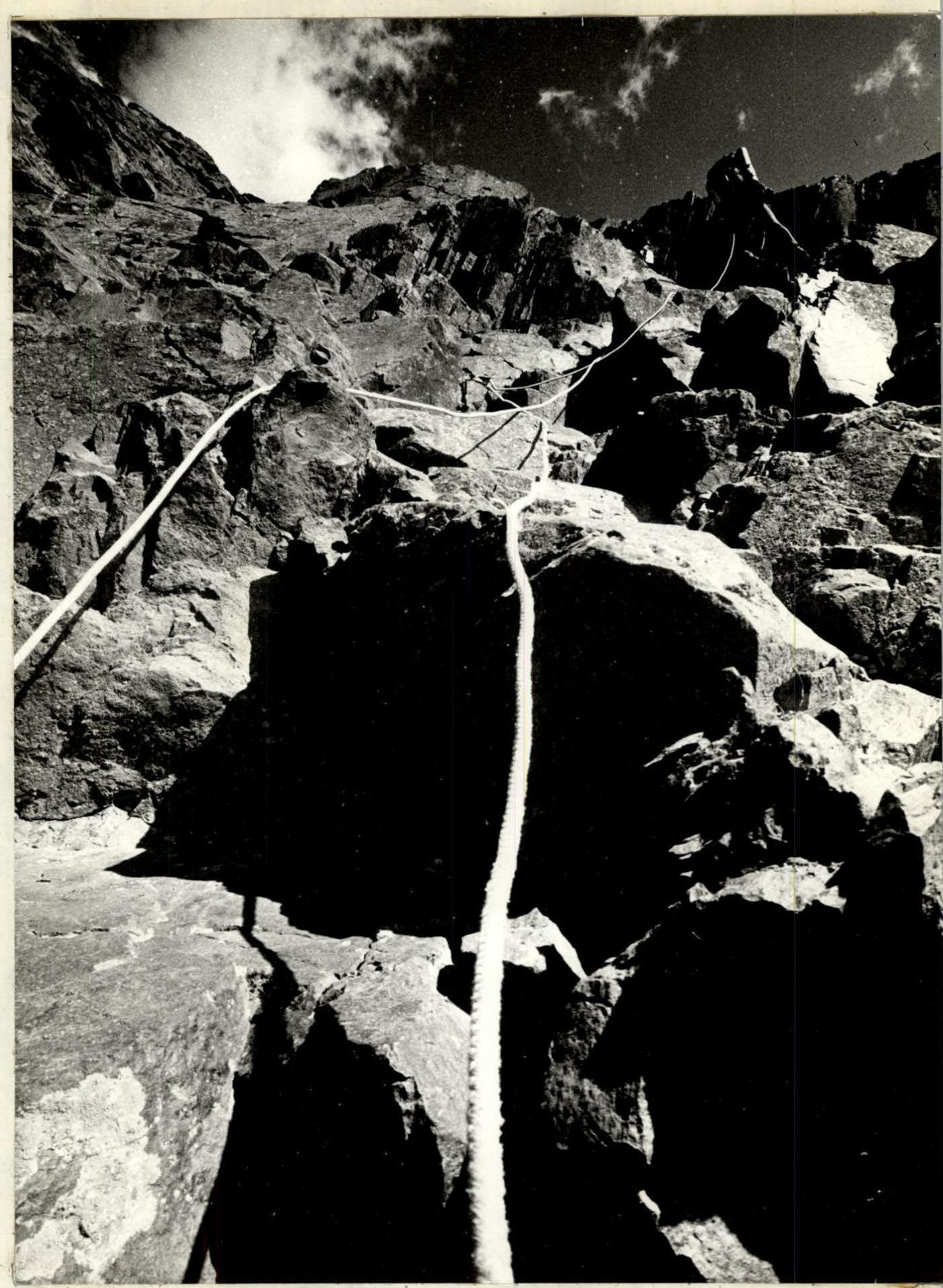
- To ensure the safety of the first climber, movement without a backpack on double UIAA ropes was used, with the application of chocks, rock, ice, and bolt pitons — photo 1, 11.
- Belay points — not less than 3 blocked anchoring points — photo 11.
- Blocking according to the Saratovkin method with automatic equal load distribution on each anchoring point.
Relief and placement features:
- Although the group can gather at the belay points, the terrain does not allow more than 2–3 people to assemble.
- There are also hanging belay points (see UIAA scheme).
Movement organization:
- All team members move along the perlines with top rope (in case of possible rockfall) — photo 4, 5, 8.
- Movement along processed sections — with bottom rope — photo 2, 6.
- Movement regime throughout the day — continuous.
Nutrition:
- Individual packs with high-quality products are used for nutrition.
- Hot meals — at overnight stays.
Route documentation:
- When moving along the route, the fourth team member records it.
- Photography — as much as possible.
The first overnight stay is organized in the left part of the snowfield, R11, on a carved rock-snow ledge, in a tent, under a cornice, for 6 people, sitting-semi-reclining.
Second overnight stay:
- On a snow-rock ledge, R20
- Under a cornice
- In a tent for 6 people
- Semi-reclining — photo 10
- The platform under the tent is 60% constructed from snow
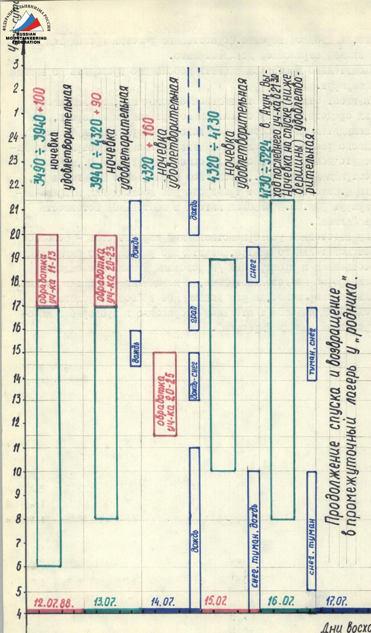
Due to worsening weather (rain throughout the night and morning, see movement graph) the tent was not dismantled the next day, and the team worked on processing the route. Bad weather did not break the team's morale, although it added complexity.
For the fourth overnight stay, having experience with snow construction, they created a convenient and safe platform:
- Under a cornice
- Tent for 6 people
- Semi-reclining
- R30
The fifth overnight stay — on descent, just below the summit, on a snow dome.
The route was completed with sufficient physical and technical reserve. When passing problematic sections, they refined the planned options, choosing the most logical and safe path. Organization of overnight stays began with at least 2 hours of daylight remaining. This allowed for quality rest and preparation for the next day's movement.
Work on setting up the camp was distributed as follows:
- Two went to process the route,
- four set up the tent and prepared dinner.
All sections of the route were traversed reliably, with necessary safety measures for all team members. The rescue team, along with a doctor, was located in the intermediate camp. Interaction was organized with LenVO gatherings, led by Dzhibráev. The LenVO base camp was located next to ours, and LenVO climbers made ascents to peak 4160, planning first ascents in the Darai-Pioz area. Observers were positioned under the route.
In the base camp, a "Kamaz" vehicle was constantly ready. There was communication with geologists who had a helicopter at their disposal. Radio communication with the team was according to the schedule and was consistently stable.
From the new equipment (for the team), they prepared a platform with a calandra-avizantova tent. The platform was not taken on the route, as suitable overnight stay locations were found. The tent has three installation options and, taken to the wall, proved itself excellently.
Table of food products and fuel
| Product name | Total weight, kg |
|---|---|
| Bread | 1.5 kg |
| Boiled potatoes | 1.0 kg |
| Salted pork fat | 0.5 kg |
| Smoked pork fat | 0.5 kg |
| Sprats | 0.75 kg |
| Dry-cured sausage | 1.2 kg |
| Instant coffee | 0.1 kg |
| Chocolate | 1.0 kg |
| Ground nuts | 0.8 kg |
| Pine nuts | 1.0 kg |
| Dried apricots | 0.8 kg |
| Raisins | 0.8 kg |
| Condensed milk | 1.2 kg |
| Tea | 0.05 kg |
| Buckwheat groats | 0.3 kg |
| Canned stew | 1.0 kg |
| Cookies | 0.4 kg |
| Caramel candies | 0.5 kg |
| Dutch cheese | 0.5 kg |
| Salted red fish | 0.5 kg |
| Total | 14.4 kg |
| "Krasmash" gas stove, 2 pcs. | 2.0 kg |
| "Krasmash" gas cylinder | 0.8 kg |
| Food and fuel total | 17.2 kg |
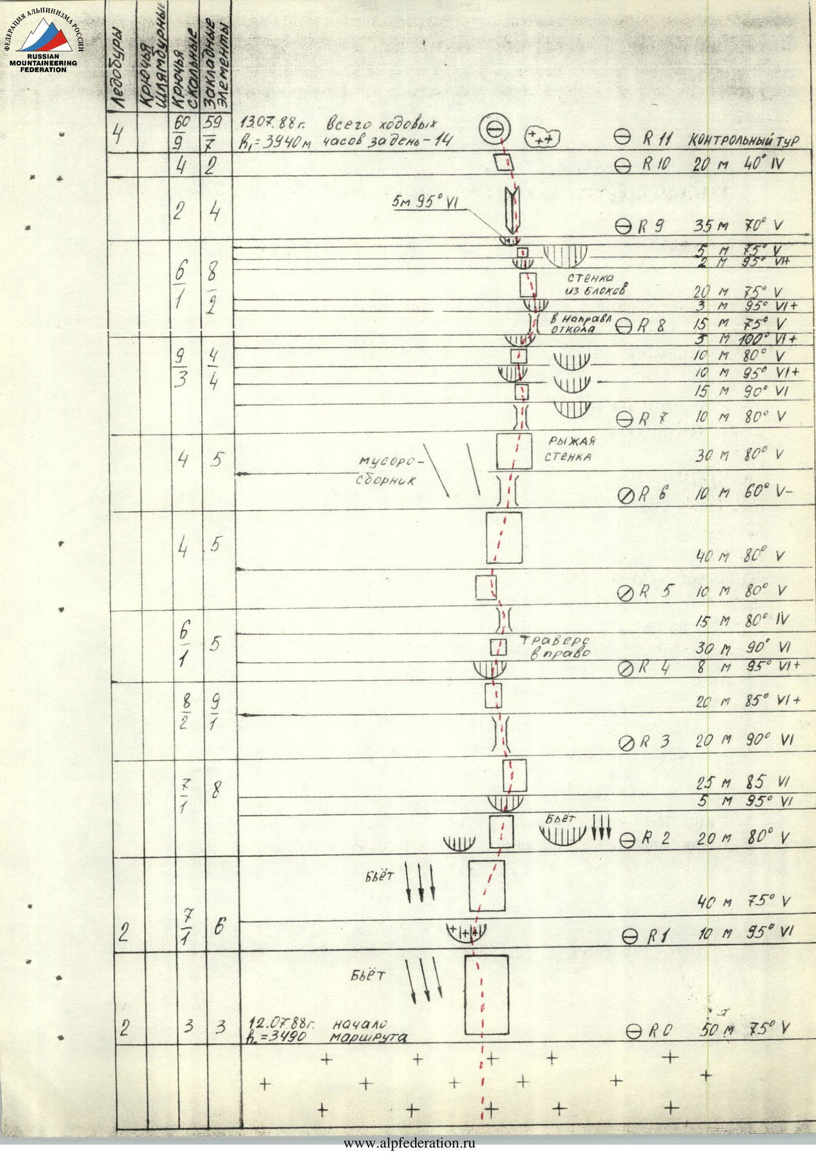
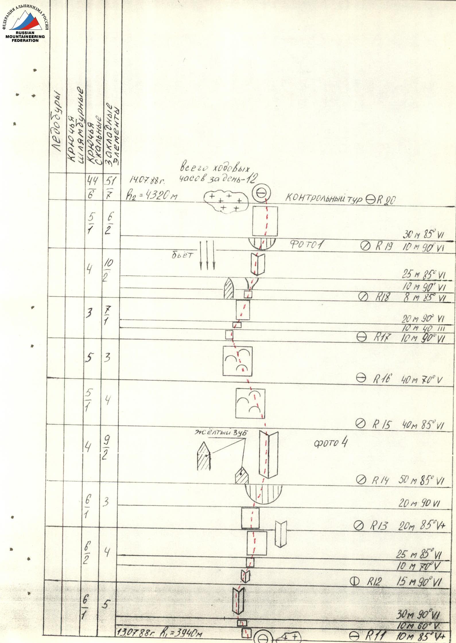
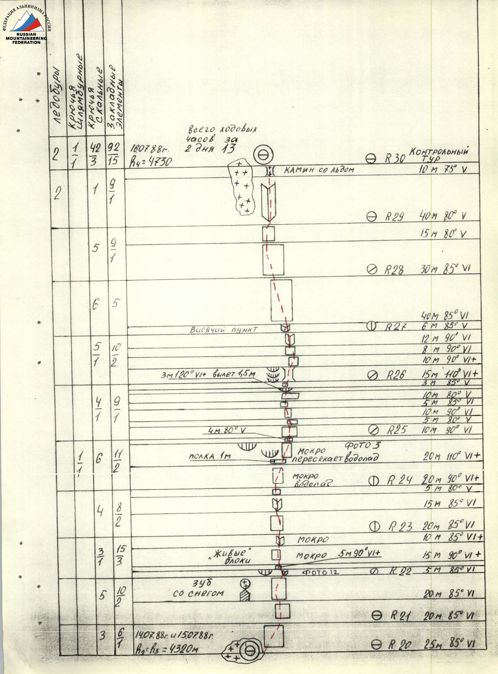
Route section diagrams (July 13, 1988 — July 16, 1988)
The following pages show diagrams of route sections, indicating length, steepness, categories of difficulty, and number of belay points.
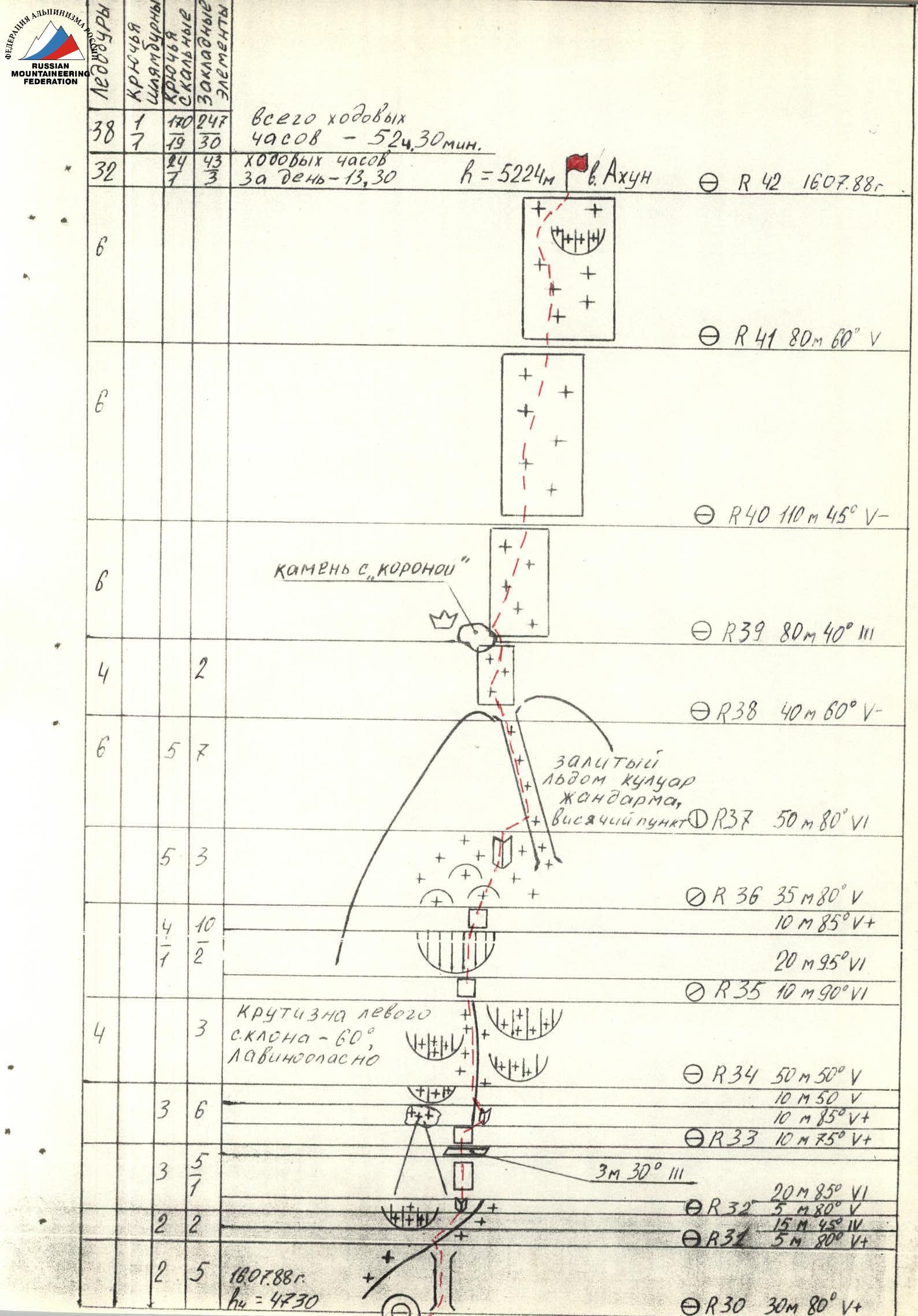
Route description by sections
Description of the route by sections. A certain difficulty is presented by the transition from snow through the bergschrund to steep, 75°, rocks — point R0. Here the route begins. The path is clearly visible — along the relief wall between two smooth slabs.
-
Section R0–R1 leads to a flattening before a snow cornice. To the left of the route, it hits, and the flattening is also traversed.
-
The snow cornice of section R1–R2 is traversed head-on. Later, in about 5 days, a passage between the snow and rock may be possible.
-
To the left, ledges are visible, but it's undesirable to go that way — rockfall hazard.
-
The cornice of section R2–R3 is traversed in the left part, with good relief. The wall has slots for chocks, monolithic.
-
Section R3–R5 bypasses the rusty mirror to the left. Monolithic, not traversed.
-
Section R5–R7 consists of monolithic rocks, traversed with a move to the right. It's not advisable to deviate left — rockfall hazard. At the end of the section, there are destroyed rocks — "loose rocks".
-
Section R7–R8 moves left of the wall with three cornices, without a clear direction. Movement is upward towards the outcrop. Pitons go well.
-
In the upper part of section R8–R9, there is a wall with a steepness of 75°, with live blocks. Movement is very cautious. The cornices of the section are traversed head-on, with good relief.
-
Section R9–R11 moves along the snowfield, it's undesirable to step onto the snowfield — you can slide. At the top of the snowfield, there is an overnight stay, under a cornice, with a hanging control cairn in a tin can.
-
The upper part of section R11–R12 is an internal corner, with complex climbing. The belay point is inconvenient.
-
Section R12–R13 is overhung by an internal corner, moving along the left part. The corner turns into a wall with a steepness of 85°, with small holds, complex climbing. To the right, it's easier, but above, the path is blocked by cornices.
-
The cornice of section R13–R14 is traversed head-on, with rocky relief. The belay point is to the right of a tooth with yellow streaks — an excellent landmark.
-
Section R14–R15 is a large internal corner, with good relief, monolithic, but very steep — 85°. Climbing is complex.
-
Section R15–R17 consists of walls like ram's foreheads, smooth, with small holds.
-
On section R17–R18, movement is towards the outcrop, with a flattening to 40° in the middle of the section. Walls have many slots, pitons and chocks go well.
-
Section R18–R19 moves along the edge of the counterfort wall. You can't enter the counterfort — it hits with ricochets from the waterfall. The section is complex, with destroyed rocks. To the right, there are wet cornices.
-
Therefore, movement is upward through the overhang and through the wall, where the overnight stay location is visible. The wall is monolithic, with relief, chocks go well. Overnight stay. Hanging control cairn.
-
Section R20–R21: destroyed steep rocks, partially wet.
-
It's practically impossible to set up an overnight stay on the snowfield of section R21–R22 — it's too steep.
-
Section R22–R23: live blocks, wet rocks, small holds. Zigzag movement right-left-right, choosing the path and aiming for the base of the internal corner.
-
On section R23–R24, climbing is less tense, with richer relief.
-
Section R24–R25: the wettest. It's crossed by a waterfall. Rocks are slippery, covered with slime, relief is limited to small holds. Climbing is complex, a bolt piton is driven.
-
Section R25–R26: movement towards a depression in the wall. Cornices alternate with walls. Steep, extreme climbing.
-
Section R26–R28: an overhang forming a niche or depression. A path to the left along the internal corner is visible, but above it's wet and the corner is blocked by a cornice. It's simpler to go straight up, although here too, climbing is extreme.
-
Section R28–R30: exit to a flattening. The wall part of the route is completed, but complex climbing will still be encountered.
-
R30 — overnight stay, hanging control cairn in a tin can.
-
From section R31, movement begins along the counterfort ridge.
-
Section R34–R35: approach to a pinnacle. The pinnacle is traversed head-on.
-
Section R35–R36: approach to a couloir filled with ice. Climbing is complex, rocks are covered with ice. When observing the route, this section didn't seem problematic. Perhaps it was complicated by bad weather. Movement is in crampons.
-
The couloir divides the pinnacle in two — section R37–R38. Movement is in crampons, belay using chocks, rock, and ice pitons.
-
Section R38–R39: approach to a rock with a "crown". Snow.
-
Section R39–R42: snow, partially ice. Steepness increases at the top. An ice cornice is bypassed to the left.
Summit! The control cairn is located on rock outcrops.
Route photographs
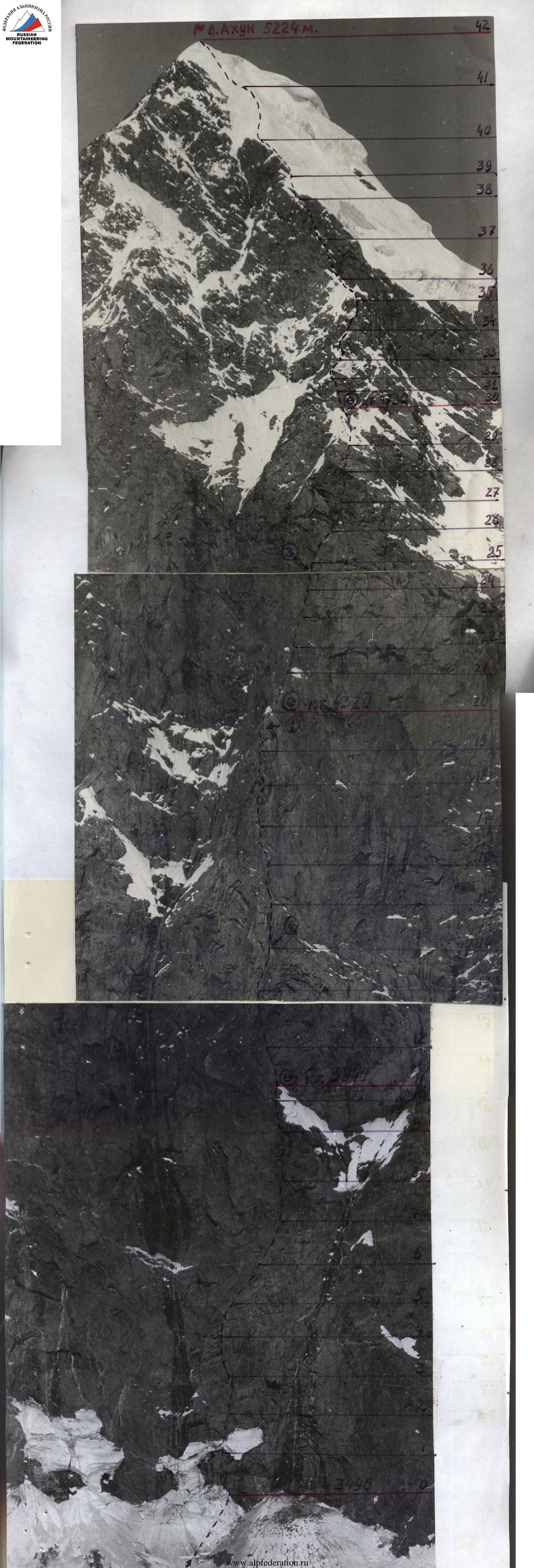
Photo 2. July 13, 1988. Movement along a processed section with bottom rope. Section R20–R21. Lens: Russar.
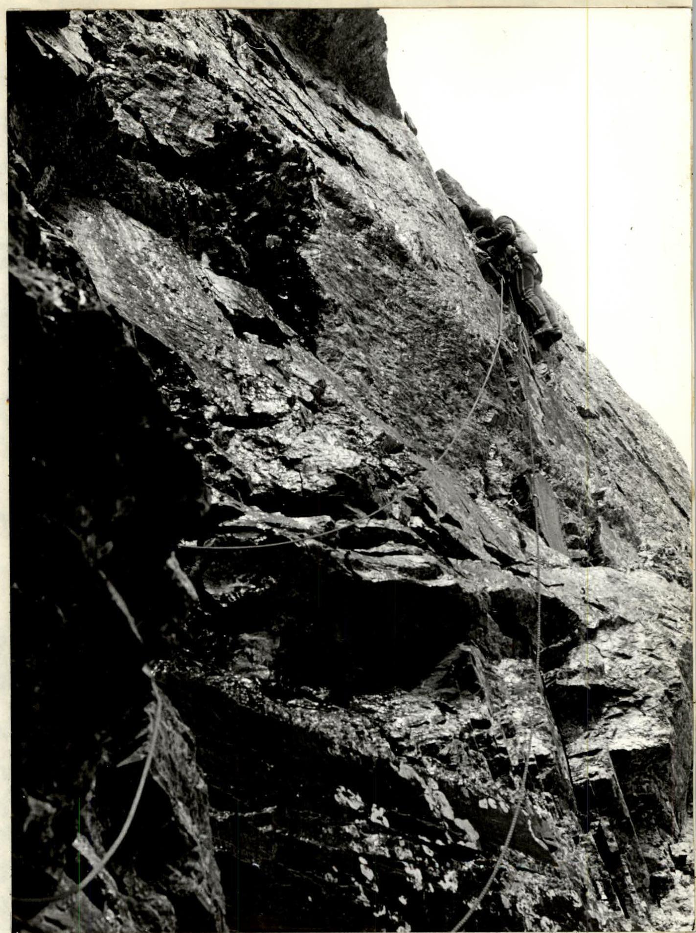
Photo 3. July 15, 1988. First climber moving without a backpack on a double UIAA rope. Section R24–R25. Lens: Russar.
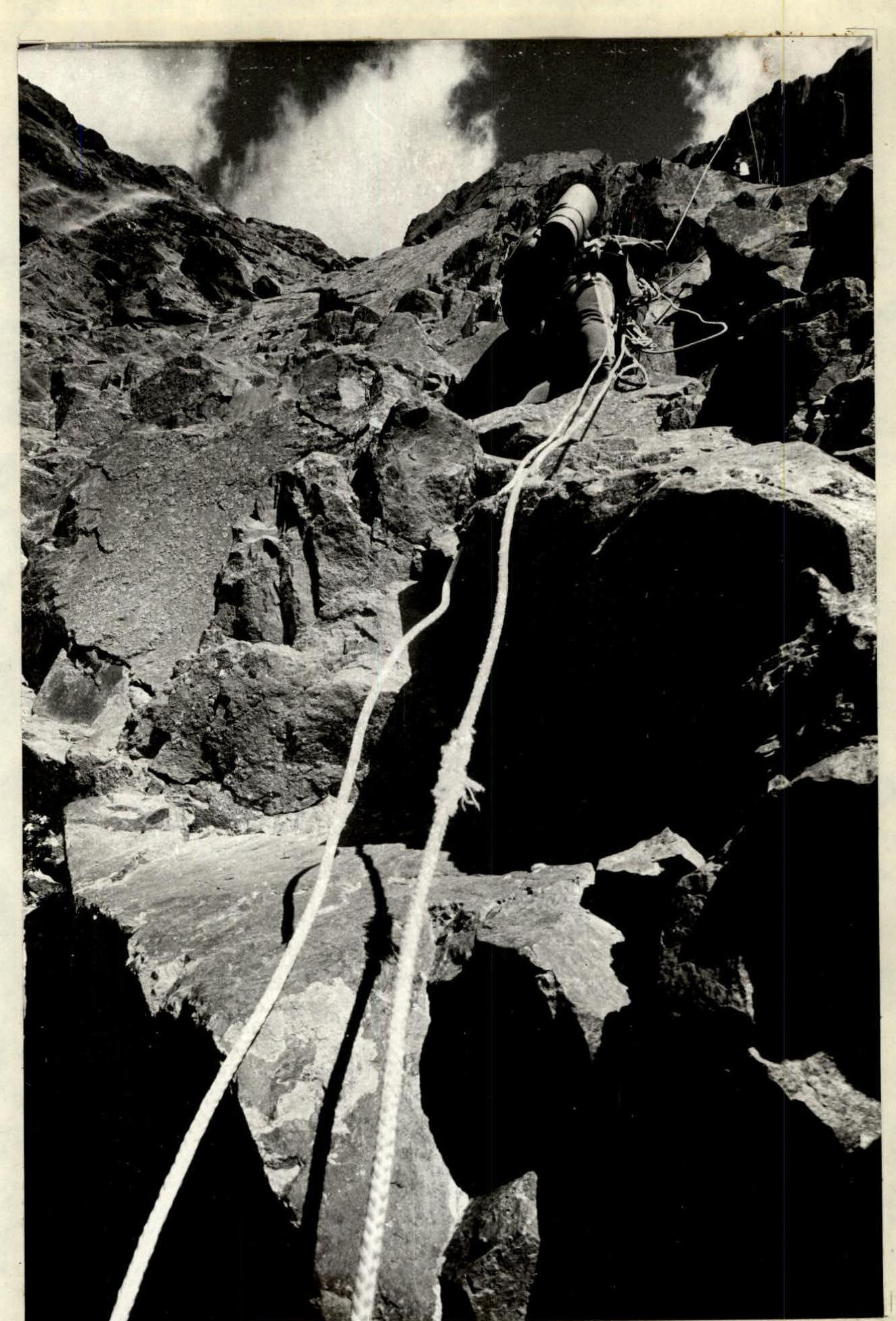
Photo 5. July 13, 1988. Top rope while moving along perlines increases safety. Lens: Russar. Rope abrasion — a trace of a stone hit.
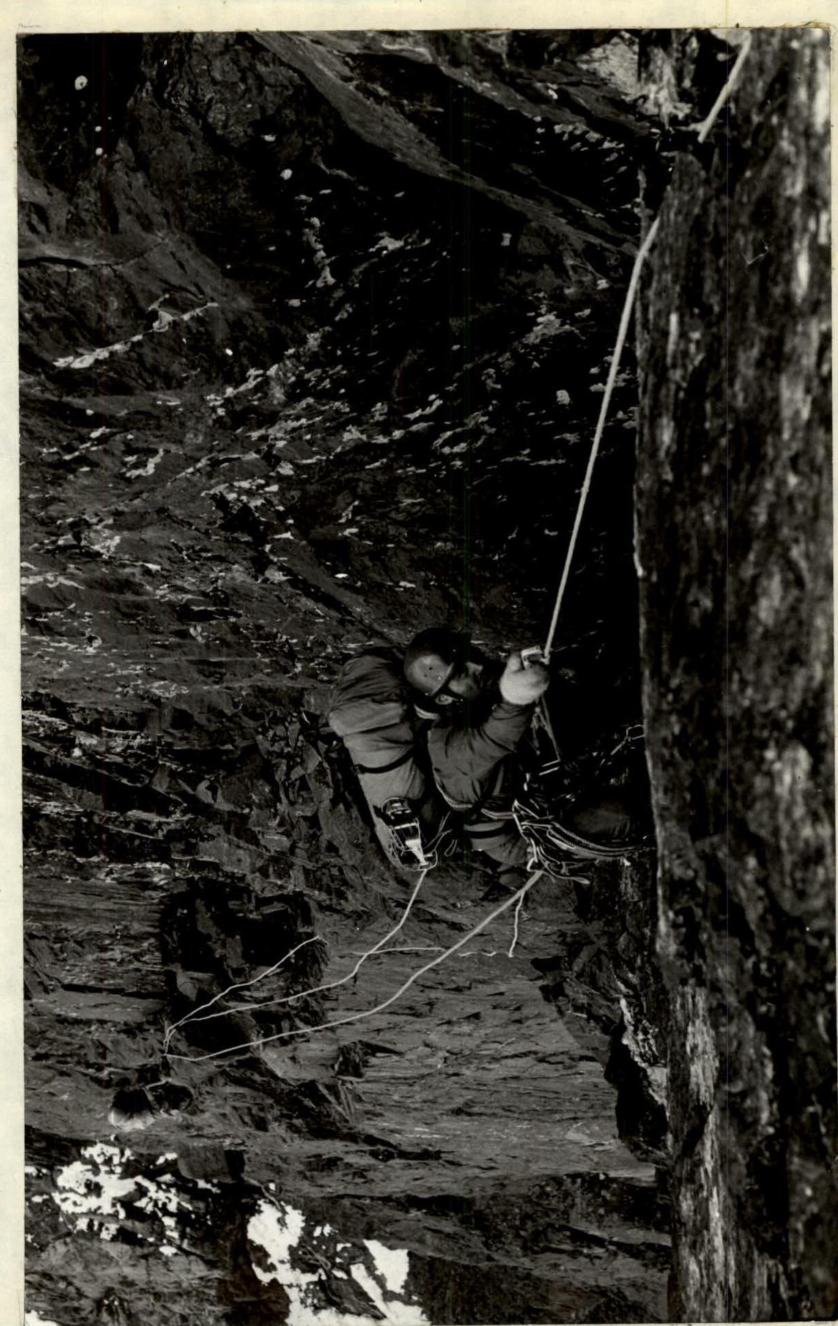
Photo 6. July 13, 1988. Movement along perlines with bottom rope. Passing equipment forward. Section R14–R15. Lens: Russar.
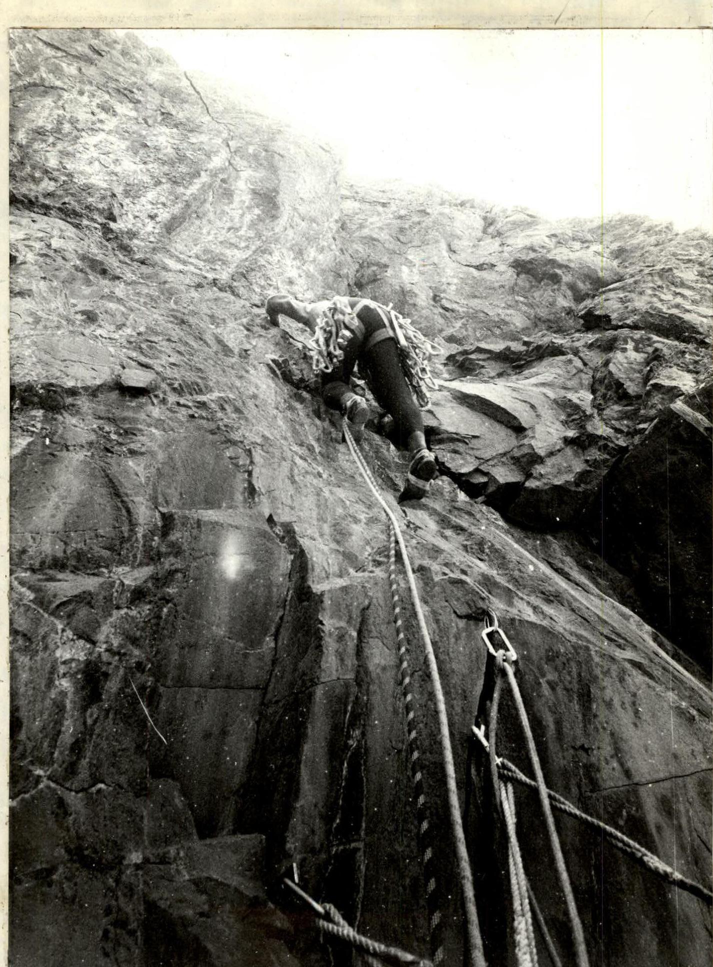
Photo 11. First climber moving without a backpack on a double UIAA rope. Belay point on three blocked points. Lens: Russar.
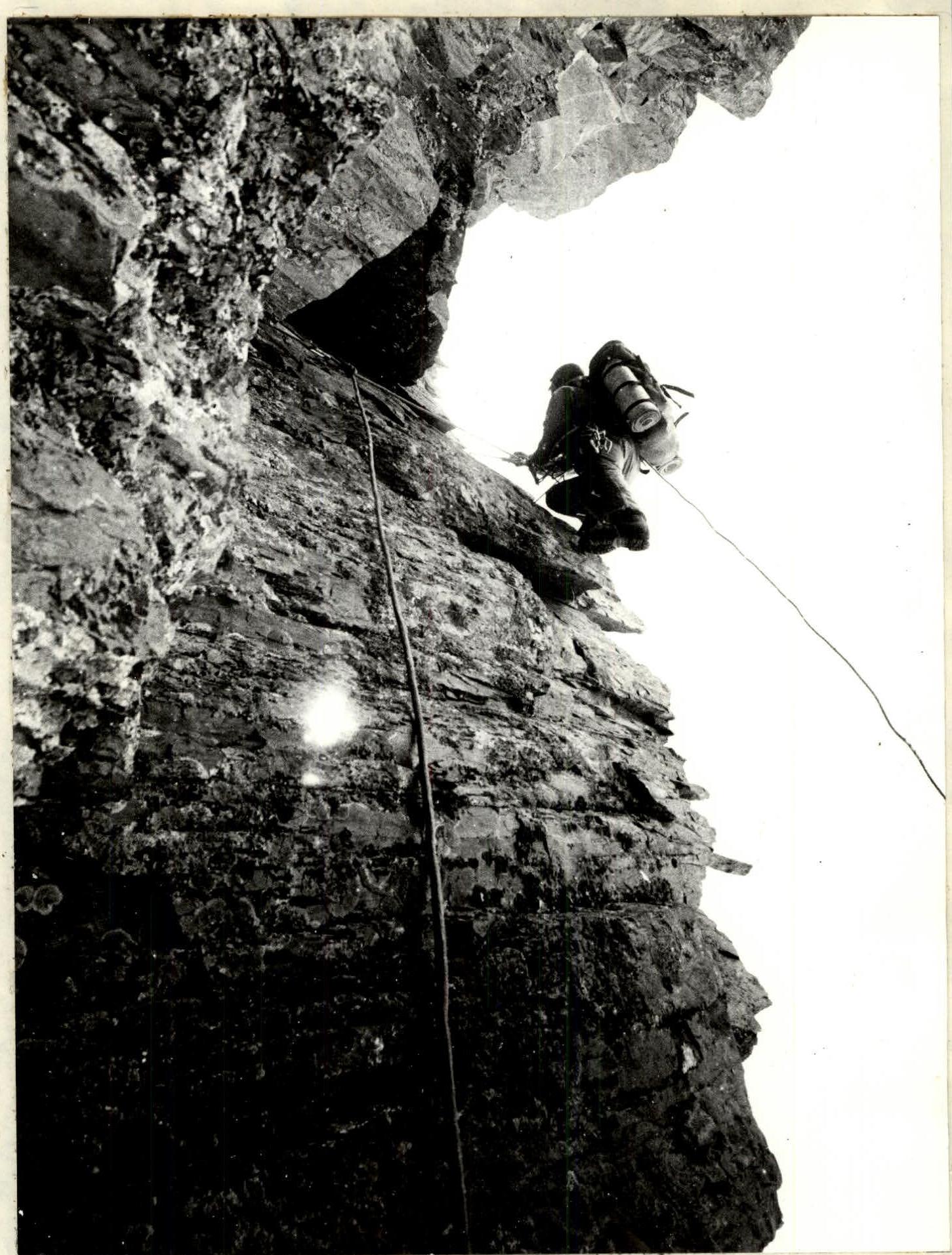
Photo 12. Cornice of section R22–R23. Lens: Russar.