Report
on the first traverse of the peak Skalnaya Stena from west to east with an exit to the ridge along the counterfort of the southern wall from the Dvoynoy pass, category 5A (approximately) in the account of the Volga Region mountaineering championship.
August 1-2, 1968, Fan Mountains, Pamir-Alay.
I. Characteristics of the Area
Between the Gissar and Zeravshan ridges of the Pamir-Alay rises a cluster of short but high ridges - the Fan Mountains. The main ridge of the Fan range stretches from west to east in a continuous arc, convex to the south. It is intersected by two indistinctly expressed meridional ridges:
- the western one - with the Laudan pass (in the north) and the Dukdan pass (in the south);
- the eastern one - from the Pasrud River (in the north) to Lake Iskanderkul.
At the intersections of these ridges are the highest peaks of the range - Chimtarga (5487 m) - the main peak of the area, located in the western node, and Big Ganiza (5415 m) - in the eastern node.
The main ridges of the Fan range are composed of metamorphosed limestones, lying in thick strata.
The weathered rocks of the peaks are very brittle. Rockfalls are a constant phenomenon in the Fan Mountains. The forms of rock weathering often have a superficial, pockmarked character. Such rock sections are very convenient to pass in rubber boots.
The Fan range is a center of significant glaciation:
- The main glaciers are concentrated mainly on the northern slopes.
- The Fan Mountains are characterized by numerous lakes of landslide and glacial origin.
The Fan range has up to 10 peaks with heights over 5000 m. The northern group of the range includes v. Chandar (5297 m) and v. Bodhana (5304 m), south of them is v. M. Ganiza (5031 m). The northwestern group includes:
- p. Energiya (5105 m)
- p. Chimtarga
- p. Mariya (5170 m).
The southwestern group includes:
- peak Sugar Head (4971 m),
- peak Moskva (5783 m).
Peak Skalnaya Stena is located on the ridge connecting the southwestern group of peaks with the northwestern one, north of the Dvoynoy pass. A steep rocky ridge, devoid of snow cover, stretching from the gorge of the left Zindon from west to east into the upper reaches of the Kaznok River, was named Skalnaya Stena by the climbers of the 1937 expedition led by E.A. Kazakova. From p. Skalnaya Stena, the ridge descends to the north to p. Kaznok and further to p. Zindon, located on the main ridge of the Fan Mountains.
In 1968, Kuibyshev climbers first ascended peak Skalnaya Stena via two routes from the south and one route from the north, as well as two routes to a nameless peak named peak Volzhsky Avtozavod (VAZ), being built in the city of Togliatti.
Skalnaya Stena was ascended:
- from the north - by the Tselovakhin group (approximately category 5B);
- from the south from the Khoroshevsky pass - by the Statsky group (approximately category 5A);
- by our group - from the Dvoynoy pass.
On the map, the height of Skalnaya Stena is marked with the figure 5112 m, but the actual height is apparently around 4800 m, since the peaks Sugar Head (4971 m) and Moskva (5183 m) tower above the peak Skalnaya Stena.
II. Group Composition
| № | Surname, name, patronymic | Mountaineering qualification | Ascents made before this first ascent |
|---|---|---|---|
| 1. | Lupanin Evgeny Stepanovich - leader | 1st sports category | p. Krasnye Zori 4A p. Moskva 4B p. Sugar Head 4B p. White Bars 4A |
| 2. | Leontiev Gennady Viktorovich - trainer | Master of Sports Candidate | p. Moskva 5A p. Kalcit 2B p. M. Mametova 3B |
| 3. | Makarov Vladimir Mikhailovich | 2nd sports category | p. Krasnye Zori 4A p. Moskva 4B p. Sugar Head 4B p. White Bars 4A |
| 4. | Ladnushkin Valery Maksimovich | 2nd sports category | p. Krasnye Zori 4A p. Moskva 4B p. Sugar Head 4B p. White Bars 4A |
The group members have experience of joint ascents, rock climbing, and general physical training.
Communication between the group and observers in the assault camp, as well as with the Tselovakhin and Statsky groups, was carried out using rockets, voice, and visually.
Description of the Route and its Passage
R1. From the pass upwards along rocks of medium difficulty with a slope of 65-70° to a site on the edge (one rope). From the site to the left upwards (60 m); further, the path goes along an indistinctly expressed couloir 50 m long and rocks with loose stones to a clearly visible red wall.
The entire rockfall-prone section was passed with the organization of insurance through pitons (8 pcs.) and through ledges.
R2. The red wall (12-15 m) is passed along a small inclined shelf 40-45° wide 10-15 cm with alternate insurance (1 piton, ledges) to a small site under the white wall. R3. The white wall consists of smoothed "ram's foreheads" with a slope of 85-90° (in some places overhanging), 40 m long. The wall is passed from the right along the course along rocks of very difficult climbing along a narrow gap to an inclined scree site with thorough piton insurance. 3 channels and four titanium pitons were hammered in.
On the site, a lift of backpacks was organized. R4. Further, again a wall 80-85° (30 m) of very difficult climbing. It is overcome along a crevice 15-20 cm wide to an inclined shelf, where another backpack lift point was organized. 5 pitons were hammered in. On the shelf, the 1st control cairn was installed. Time from the pass to the 1st control cairn - 4 hours. R5. From the control cairn, two ropes to the left upwards along rocks with a slope of 75° to a couloir (in the lower part dark red). Rocks! Insurance through pitons and channels (7 pcs. + 1) and through ledges. Along the couloir 40 m, slope 70-75°, climbing is difficult, insurance is piton. Exit to a site colored like red brick. 4 pitons were hammered in, on the site insurance is through a ledge. R6. From the site along rockfall-prone rocks (60-65°) to the left upwards two ropes in the direction of two "fingers" into the window between them under the red-white monolithic wall of difficult climbing (80-85°). The wall is overcome from the left along the course along a crevice (30-35 m) under a large overhanging stone. Insurance through pitons (6 pcs.), under the stone, you can organize good rappel insurance through a ledge. R7. After the red-white wall, there are still four ropes of medium-difficulty rocks with good holds in the direction of the ridge (landmark - a large gray stone on the ridge). Movement is alternate, insurance is through ledges and pitons (10 pitons). 15 m from the large gray stone on the ridge in the direction of the summit - 2nd control cairn. Time from the pass to the 2nd cairn - 7 hours. R8. The summit is close but hidden by the saw of the ridge. We feel tired after very intense work. We take a 20-minute rest and have a snack with sandwiches and condensed milk.
From the 2nd cairn, along the ridge, there is an easy descent to a saddle under a large gendarme. Movement is simultaneous. The gendarme is bypassed from the right along a snow-ice isthmus 10-12 m wide under rocks 65-75°. Insurance under the gendarme is through a piton.
The first one goes out on the entire rope and hammers in another piton. The rest follow along the fixed rope to him. Along the rocks (very rockfall-prone) two ropes to the ridge. 7 pitons were hammered in. Climbing is difficult on smoothed shelves, there are many stones, and small streams flow in some places. Further along the ridge, the path goes to a chimney leading to the summit. When approaching the chimney, we overcome a small section of formed ice (3-4 m); the chimney (8 m) is overcome on expansions and on friction. 2 pitons were hammered in - before the formed ice and in the lower part of the chimney. Time from the pass to the summit - 9 hours. From the summit, we retrieved a note from the Statsky L.N. group. R9. From the summit, the path goes along the ridge to the right to the exit onto snow on the left side of the ridge. Movement is simultaneous, in some places the rope is thrown over ledges. Along the snow, the path is easy to a characteristic "snow bowl" (crater) - 1 hour from the summit. Here the group stopped for the night at 19:00. The overnight site is very good:
- A high snow wall on three sides reliably protects the bivouac from the wind.
- There is water.
- There are two sites for a tent, made by us and the Tselovakhin group, with which we met and had mutual consultations.
There is also a site for an overnight stay 15 minutes' walk from the summit before exiting onto snow.
At 21:30 from the overnight site, we fired two green rockets. We immediately received a response signal.
R10. The next day at 10:00, along the snowy ridge, movement is simultaneous to the exit into a serious couloir. The character of the rocks in the couloir is of medium complexity, 20-25 m long. Descent is possible without pitons with the organization of insurance through a ledge and subsequent fixing of it for the organization of fixed ropes. Further descent is along medium and easy rocks to a "gendarme" standing out on the ridge, gray in color. Movement is simultaneous, insurance is through ledges.
R11. From the "gendarme", a rappel 20 m to a small inclined site. From it, a rappel 30-35 m to a small snowy plateau with a lake of blue water. In this case, we used a 40 m reepschnur, having extended it with the main rope.
R12. We continue moving along the ridge and along inclined slabs covered with stones, orienting ourselves towards a small gray gendarme, leaving to the right along the course a red couloir descending down to the moraine of the cirque between Skalnaya Stena and VAZ. The couloir stands out sharply with its color and is clearly visible from the ridge. Very prone to rockfalls.
Movement to the "Gray gendarme" is relatively easy but requires careful insurance, as most of the path is along inclined slabs and shelves. Insurance is through pitons and ledges. 9 pitons were hammered in.
On the "Gray gendarme" is the 3rd control cairn. Time from the overnight stay to the 3rd cairn - 3 hours. R13. The gendarme is bypassed from the left along the course to a site with snow. Movement is simultaneous. Further descent along a couloir 25-30 m with an exit to a large overhanging stone. From the overhanging stone, a rappel (20 m) onto a shoulder on the ridge.
From the shoulder, another rappel 40 m with a descent to the northern side of the ridge. Approximately 30-35 m - again a rappel 8-10 m along completely smooth, ledge-less rocks.
R14. Further along the ridge: a small ascent; from it - a rappel 40 m. Then on the ridge, there are two small gendarmes: the first is taken head-on; the second is bypassed from the left along snow. Continuation along the ridge with an exit to a large stone, which is bypassed from the right along shelves (2 pitons) in the direction of a large "gendarme". The "gendarme" is bypassed from the left. A "sporting" descent (35 m) in the direction of two large stones - into the window between them.
R15. From this place, sticking to the right side, there is a whole series of "sporting" descents (7-8) on a full rope in the direction of a deep gap in the ridge. Further from the main ridge - a descent to the right to the southern counterfort (red in color).
Time from the overnight site to the counterfort - 8 hours. Before exiting onto the southern counterfort of the eastern part of the ridge, a 2nd overnight stay on the ridge is possible. There is a site and snow. R16. Four 40-meter rappels:
- Descent - with a move to the left into a not-brightly expressed couloir. Gathering of the group on a very small site.
- Descent - along the couloir downwards.
After the 2nd descent, we traverse the counterfort and move into the right couloir, due to the shorter distance along the right couloir to the snow at the foot of the wall.
In the couloir, along the wall on its left side, there are two more rappels to the snow. We descended onto the snow at 21:00. Time from the overnight stay - 11 hours.
On the way to the assault camp at 21:30, we fired a green rocket. At 22:00, already in the guest camp, with headlamps, along the trodden trail, the group returned to the assault camp in the upper reaches of the Kaznok River.
Conclusion, Recommendations
On the entire route, the first (on the ascent) and the last (on the descent) went without backpacks. The rest of the team members ascended along the fixed rope where necessary. On the most difficult sections, they organized the lifting of backpacks. The locations for insurance were chosen to be as safe as possible.
Rocks on sections R1, R7, R11 posed a particular danger, so all participants wore helmets.
It was possible to organize an overnight stay in a wind-protected location.
The length of the route on the ascent is about 700 m, of which 600-650 m is the steep part of the counterfort of the southern wall. Complex sections with an average slope of up to 75-80° make up 200-250 m. 84 pitons were hammered in on the route, including 57 pcs. on the ascent. 19 pitons were left on descent. It should be noted that the monolithicity of the rocks does not allow the use of conventional rock pitons with the necessary efficiency. In some places, it is desirable to use piton hammers, as well as wedges and channels.
Table of Main Characteristics of the Traverse Route of Skalnaya Stena from West to East with Ascent along the Counterfort of the Southern Wall from the Dvoynoy Pass
| Date | Section № | Average slope | Length | Characteristics of sections and their origin by relief character | by technical difficulty | by method of overcoming and insurance | Pitons hammered in | Time | Note |
|---|---|---|---|---|---|---|---|---|---|
| 5 | 6 | 7 | 8 | 9 | 10 | ||||
| August 1, 1968 | R1 | 65-70° | 150 m | rocky | medium difficulty | Free climbing with piton insurance and through ledges. | 8 | 1 h 30 min | |
| R2-R3 | 85-90° | 50 m | rocky | very difficult | Free climbing with piton insurance. | 7 | 1 h 30 min | Backpack lift. | |
| R4 | 80-85° | 30 m | rocky | very difficult | —"— | 6 | 1 h | Backpack lift, 1st control cairn. | |
| R5 | 75° | 120 m | —"— | medium difficulty | Free climbing with piton insurance and through ledges. | 11 | 1 h | ||
| R6 | 60-65° | 120 m | —"— | medium and difficult (35 m). | Climbing with piton insurance and through ledges. | 6 | 1 h | ||
| R7 | 60° | 160 m | —"— | easy and medium | Climbing with piton insurance and through ledges. | 10 | 1 h | 2nd control cairn. | |
| R8 | 65° | 150 m | rocky, rocky-snow | medium difficulty | Free climbing with piton insurance. Simultaneous movement. | 9 | 2 h | summit | |
| R9 | Ridge | rocky-snow | easy | — | 1 h | Overnight stay | |||
| August 2, 1968 | R10 | Ridge | snowy, rocky | easy, medium (couloir) | |||||
| R11 | 85-90° | 60 m | rocky | difficult | rappel, sporting | snowy plateau with a lake | |||
| R12 | Ridge | — | rocky | medium difficulty | descent climbing with piton insurance. | 9 | 3 h from overnight stay | 3rd control cairn. | |
| R13 | 70-80° | 130 m | snowy-rocky, rocky | medium difficulty | rappel | ||||
| R14 | 80-85° | 100 m | rocky | medium difficulty | rappel, sporting | 2 | |||
| R15 | 85-90° | 300 m | rocky | difficult | sporting | — | 8 h from overnight stay | ||
| R16 | 80° | 160 m | couloirs | very difficult | rappel | — | 11 h from overnight stay | exit onto snow |
Map of the Area
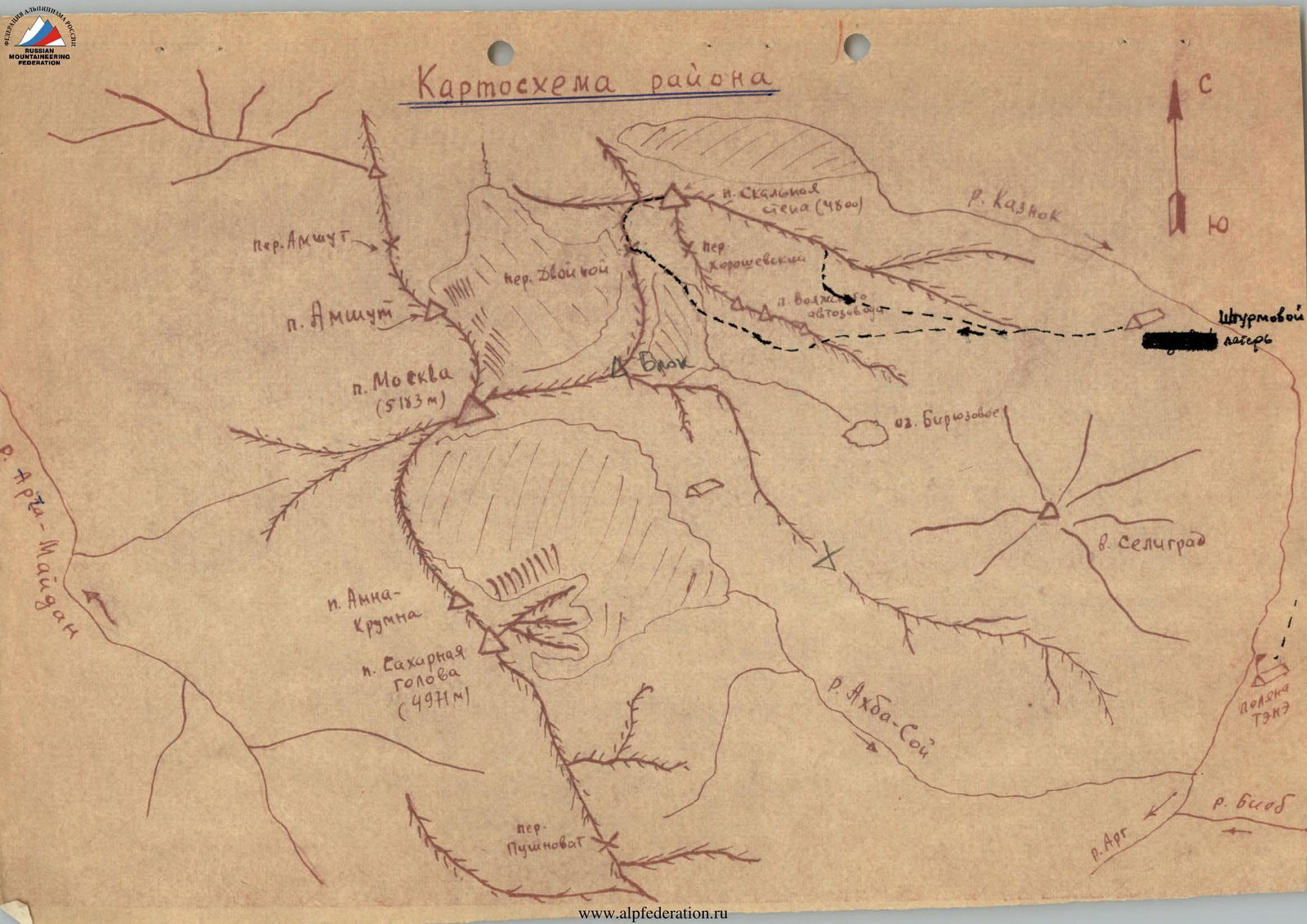
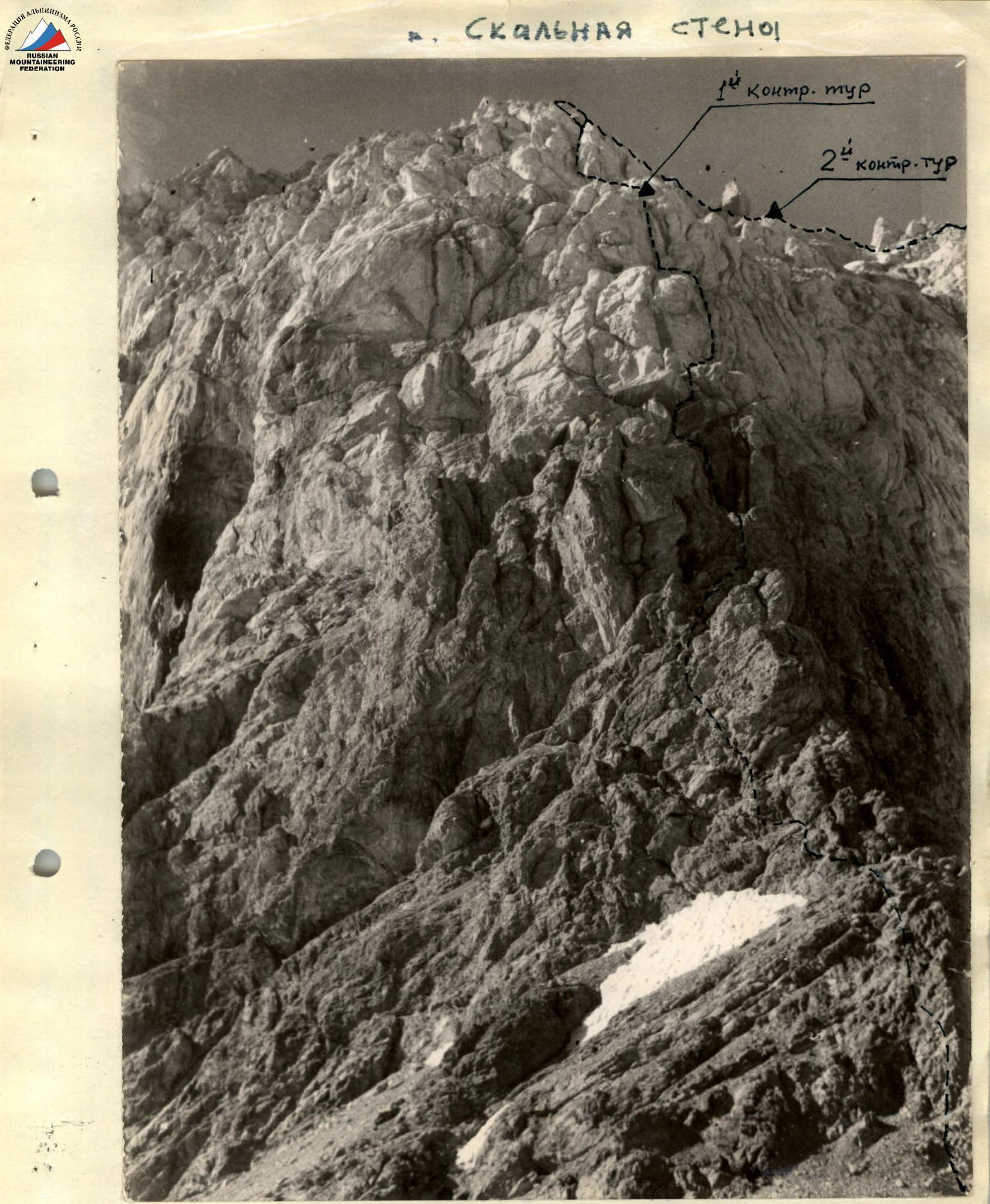
Photo #1. Wall section from the Dvoynoy pass - Ascent path of the group.