- Sports organization: Sports club of Moscow Aviation Institute
- Ascent class: Technical
- Ascent area: Pamir-Alay, Fann Mountains
- Ascent route: Peak Sakharnaya Golova (4971 m) via the "pillar" (center of the north face)
- Ascent characteristics: a) height difference 990 m (1095 and 65°); b) average steepness: 1) "pillar" — 75°, 2) route — 65°; c) length of the "pillar" — 675 m
- Pitons driven: a) rock — 132 pcs., b) ice — 35 pcs., c) expansion bolts — none
- Number of climbing hours: 42 hours
- Number of bivouacs and their characteristics: 3 bivouacs: 1st — sitting on ledges, two people, 2nd — semi-reclining, all together, 3rd — semi-reclining, all together
- Tactics: movement in two rope teams with interaction, first person goes without a backpack
- Team composition: Vanin V.V., Master of Sports of International Class, team leader. Participants: Stepanyants G.A. — Candidate for Master of Sports, Nazarov I.V. — 1st sports category, Shuvalova V.A. — 1st sports category
- Team coach: Master of Sports, Honored Coach of the RSFSR Puchkov Lev Nikolaevich
- Date of departure and return: July 1, 1978 – July 4, 1978
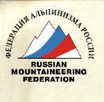

Fig. 3. General view of the peak.
Route Description
June 30, 1978. From the base camp (Fig. 1) down along the Kaznok River to its confluence with the Akhbasay River. Then up along the trail to the lateral moraine of the Akhbasoy glacier, where there is a convenient spot for a bivouac. The journey from the base camp to the bivouac takes 4.5–5 hours.
July 1, 1978. Section R0–R1. Three ice pitons were driven. From the bivouac (Fig. 2, 3) on the left moraine of the Akhbasoy glacier, cross the glacier in the direction of the north face of Peak Sakharnaya Golova. Along a snow cone with a steepness of 30–35°, approach the bergschrund, which is overcome in its narrowest part, followed by a traverse to the right. To overcome this section, it was necessary to chop off an overhanging cornice. To overcome the ice wall, ladders were required. During the traverse, it was necessary to cut steps.
Section R1–R2. The length of the section is 150 m, average steepness is 65°, 18 rock and 8 ice pitons were driven.
After the bergschrund, along the ice slope (60°) to the right and upwards, in the direction of a large rock island, and up along it. The rocks are covered with flow ice. From the rock island, along the ice (60°) in the direction of a small rock island, and from it upwards along the ice to a gully that leads to a small ledge on the rocks. On the rock islands, the slabs are covered with flow ice, making climbing difficult.
Section R2–R3. The length is 80 m, average steepness is 75°, 16 rock pitons were driven. This section marks the beginning of the "pillar". From the small ledge, traverse left for 10 m and then up a chimney (at the start of the chimney, there is a control cairn). In one place, the chimney overhangs at 95°. The chimney is followed by a crack, which is difficult to climb using artificial holds. The crack overhangs in places up to 100° (ladders). This crack leads to the top of the "carrot" — a ledge that can accommodate 2 people.
Section R3–R4. The length is 35 m, steepness is 90°, 9 pitons were driven. From the "carrot", straight up a smooth wall. Small holds, very difficult climbing using ladders. The first person climbs without a backpack and in galoshes. After the wall, there is a small ledge. On this section, the backpacks were pulled up. On the ledge, there was a sitting bivouac.
July 2, 1978. Section R4–R5. The length of the section is 80 m, average steepness is 70°, 15 pitons were driven.
From the ledge, left and upwards, a 20 m slab. Climbing is based on friction, with microscopic holds. The slab's steepness is 60°. The slab leads to a 20-meter crack, which is overcome with extremely difficult climbing using ladders. The crack leads to the edge of the "pillar", along which 30 m upwards, followed by a 10-meter sheer wall, after which there is a small ledge.
Section R5–R6. The length of the section is 40 m, average steepness is 75°, 8 pitons were driven.
Then, traverse left along the wall for 10 m, difficult climbing, and up along a weakly defined ridge for 30 m under overhanging red rocks.
Section R6–R7. The length of the section is 60 m, average steepness is 80°, 10 rock pitons were driven.
Along a crack, through overhanging red rocks, 20 m upwards (ladders) — exit to the edge of the pillar. Then straight up 40 m to an inclined ledge. The section is climbed with the pulling up of backpacks. On the inclined ledge, there was a semi-reclining bivouac.
July 3, 1978. Section R7–R8. The length of the section is 80 m, average steepness is 75°; 14 pitons were driven.
From the inclined ledge, traverse left and upwards along broken rocks for 40 m. Climbing is difficult. From the broken rocks, straight up along rocks with few holds for 40 m to a chimney. Climbing is very difficult.
Section R8–R9. The length of the section is 110 m, average steepness is 80–85°, 27 pitons were driven.
Up the chimney for 40 m (width from 1 m to 0.5 m). In places, the chimney overhangs, very difficult, with almost no holds. In the chimney, there is a plug where a belay point was organized. On the plug, only two people can stand. Further up the chimney for another 20 m. Part of this chimney is climbed using jamming and friction. The chimney overhangs, very difficult (ladders). There are few places to drive pitons. Then the chimney narrows and turns into an overhanging crack (20 m). Further along the wall and an oblique ledge to the right and upwards, exit to the top of the "pillar". This is another 30 m (2nd control cairn). On the top of the "pillar", there was a semi-reclining bivouac. On this entire section, the backpacks were pulled up.
July 4, 1978. Section R9–R10. The length of the section is 100 m, average steepness is 60°, 14 rock and 2 ice pitons were driven.
From the bivouac, left and upwards, a ridge of moderate difficulty leads to a large slab. The length of the ridge is 40 m. Further along the slab (60°) with few holds (part of the slab is covered with flow ice). The length of the slab is 60 m.
Section R10–R11. The length of the section is 80 m, average steepness is 60°, 8 rock and 5 ice pitons were driven. From the slab, exit to smooth flow ice (50°). Along the ice, left around the corner into an ice gully (on the left, water flows from the wall and fills the gully). In the gully, there is a small rock island where a belay was organized (2 people can stand). Along the ice gully for 40 m — exit to a rock ridge and to the left of it, a wall 40 m that leads to a ledge before an ice dome. The rock wall is located in a passage along a crack with an overhanging rock. Climbing is difficult.
Section R11–R12. The length of the section is 240 m, average steepness is 45–50°, 17 ice and 2 rock pitons were driven.
From the platform near the ice dome, straight up along the ice for 200 m. Exit to the summit along a flattening ice slope turning into snow (crampons). This is another 40 m. On the summit at 14:00. Descent to the west, onto a saddle between the Amna-Krupa pinnacle and Peak Sakharnaya Golova. At 21:00, the group descended to a meadow at the foot of Peak Vilnius.
Team captain, Master of Sports of International Class Vanin V.V.
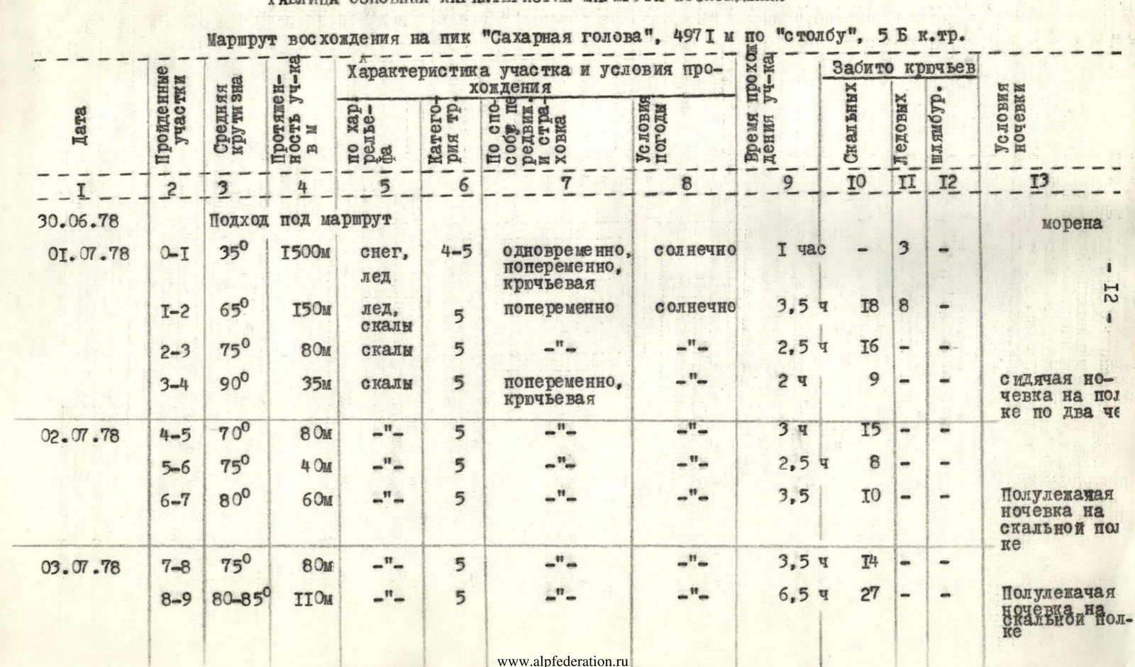
TABLE OF MAIN CHARACTERISTICS OF THE ASCENT ROUTE Ascent route to Peak "Sakharnaya Golova", 4971 m via the "pillar", 5B category of difficulty.
| Date | Length of section, m | Average steepness, ° | Characteristics of section | Category of difficulty | Characteristics and conditions of passage | Time taken to pass the section, h | Pitons driven | Conditions of bivouac |
|---|---|---|---|---|---|---|---|---|
| Rock | Ice | Expansion bolts | ||||||
| June 30, 1978 | Approach to the route | |||||||
| July 1, 1978 | R0–R1 | 35 | 1500 | Snow, ice | 4–5, simultaneously, alternating, sunny | 1 | – | 3 |
| R1–R2 | 65 | 150 | Ice, rocks | 5, alternating, sunny | 3.5 | 18 | 8 | |
| R2–R3 | 75 | 80 | Rocks | 5 | 2.5 | 16 | – | |
| R3–R4 | 90 | 35 | Rocks | 5, alternating, piton belay | 2 | 9 | – | |
| July 2, 1978 | R4–R5 | 70 | 80 | – | 5 | 3.5 | 15 | – |
| R5–R6 | 75 | 40 | – | 5 | 2.5 | 8 | – | |
| R6–R7 | 80 | 60 | – | 5 | 3.5 | 10 | – | |
| July 3, 1978 | R7–R8 | 75 | 80 | – | 5 | 3.5 | 14 | – |
| R8–R9 | 80–85 | 110 | – | 5 | 6.5 | 27 | – | |
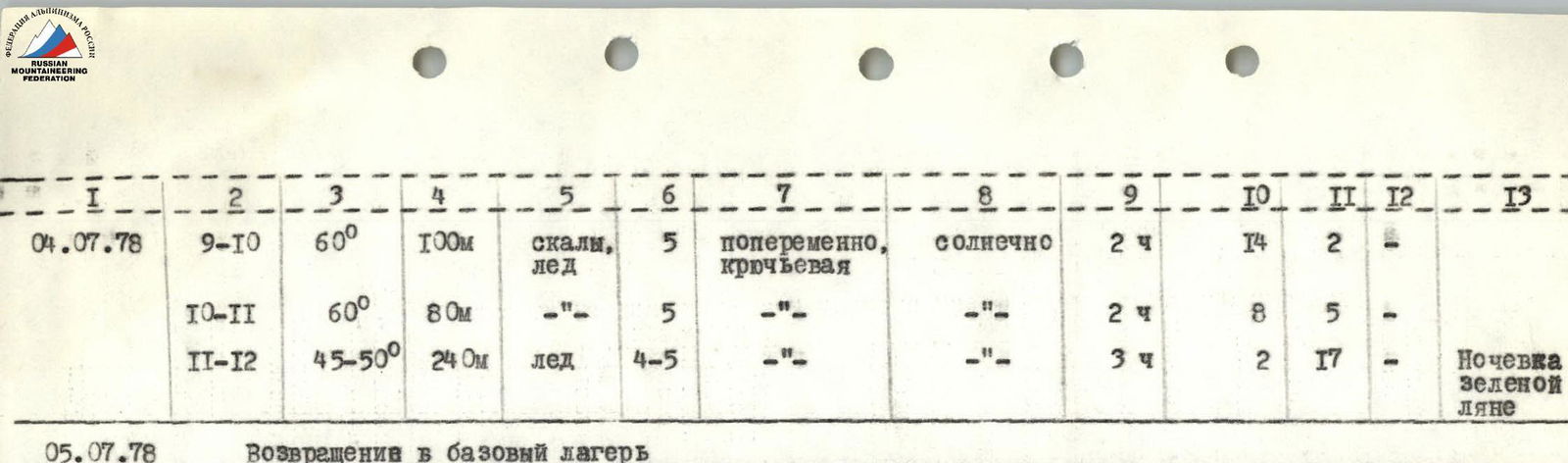
| July 4, 1978 | R9–R10 | 60 | 100 | Rocks, ice | 5, alternating, piton belay, sunny | 2 | 14 | 2 |
| R10–R11 | 60 | 80 | – | 5 | 2 | 8 | 5 | |
| R11–R12 | 45–50 | 240 | Ice | 4–5 | 3 | 2 | 17 | |
| July 5, 1978 | Return to base camp |