Passport
- Technical class.
- Pamir-Alay. Fann Mountains (northern part). Imat Valley.
- Peak "Independence of Tajikistan" via the Northwest Edge.
- Proposed 5A category of difficulty. First ascent.
- Height difference — 700 m, total route length — 850 m, length of the wall section — 660 m.
- Hammered in rock hooks — 43 pcs. placed protection — 52 pcs.
- Climbing hours — 15 hours.
- Leader: Yuri Baikovsky, Master of Sports Participants: Anatoly Sharipov, Candidate for Master of Sports, Andrey Pilkevich, 1st category (Master of Sports in mountaineering)
- Coach: Yuri Baikovsky, Master of Sports, 1st category instructor.
- Ascent made on September 5, 1996.
- Organization: Ministry of Emergency Situations of the Republic of Tajikistan, State Committee for Physical Education and Sports of the Republic of Tajikistan.
Dushanbe–96
Overview of the Ascent Area
Peak "Independence of Tajikistan" is located in the Imat Glacier area, in the same ridge as the peaks Bolshaya Ganiza and Saroch. The following peaks are part of this ridge: Bolshaya Ganiza, Linkor, Kiorn, Stimul, Peak "Independence of Tajikistan", Saroch.
The first ascent to the summit was made in 1993 to celebrate the Independence Day of the Republic of Tajikistan; the structure consists of marbleized limestone. There is a small glaciation on the northern side. On the western side, snow remains at the end of summer. The north-eastern ridge has destroyed rocks.
Route: from Dushanbe through the Anzob Pass to the city of Zarafshan 1, then turn left into the Pasrut-dara valley. Drive to the village of Nasrut (6 km) and to the upper village of Marguzor (through the pass). From this village to the bridge and the confluence of the Imat River. The fork has a local name Sanghi-Safed due to the bizarre jumble of stones on the slopes and ridges surrounding this place. From the fork, 1 km to the left along the road to the summer pastures. Then follow the trail on the right side of the river for 2–2.5 hours to the summer pastures. From the summer pastures, 30 minutes along the river to the arch forest. There are convenient places for helicopter landing.
In the Imat River valley, a base camp can be organized. From the valley, go along the northwestern slope along the trail to the Saroch cirque area — 2 hours. Pass through the forest zone and reach the flat fields at the foot of Peak Independence. Convenient places for overnight stays. There is ice, and water can be collected during the day.
You can also organize a bivouac higher, within an hour's walk on the Saroch glacier moraine. There is water.
From the bivouac, the approach to the start of the route takes 1–1.5 hours. The area is promising in terms of sports. Convenient places for organizing a base camp. Convenient places for helicopter landing. There are peaks in the area that can be climbed with 1–5 categories of difficulty. Short approaches to the routes.
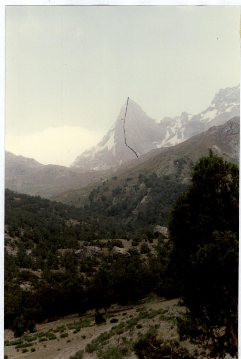
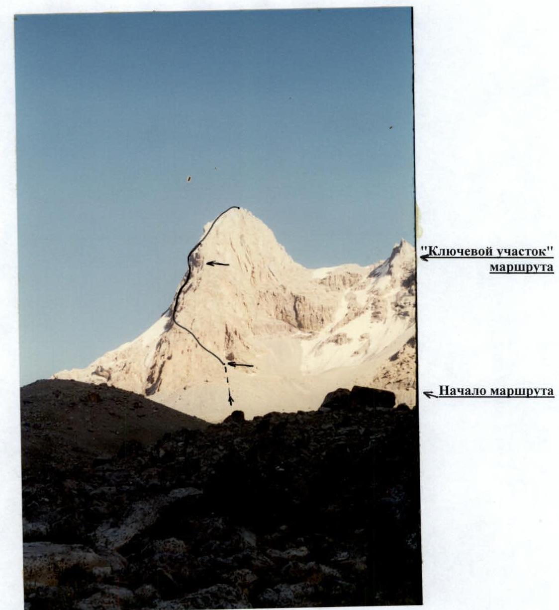
General View of the Summit
(Frontal photo. Taken from the shepherds' summer pastures)
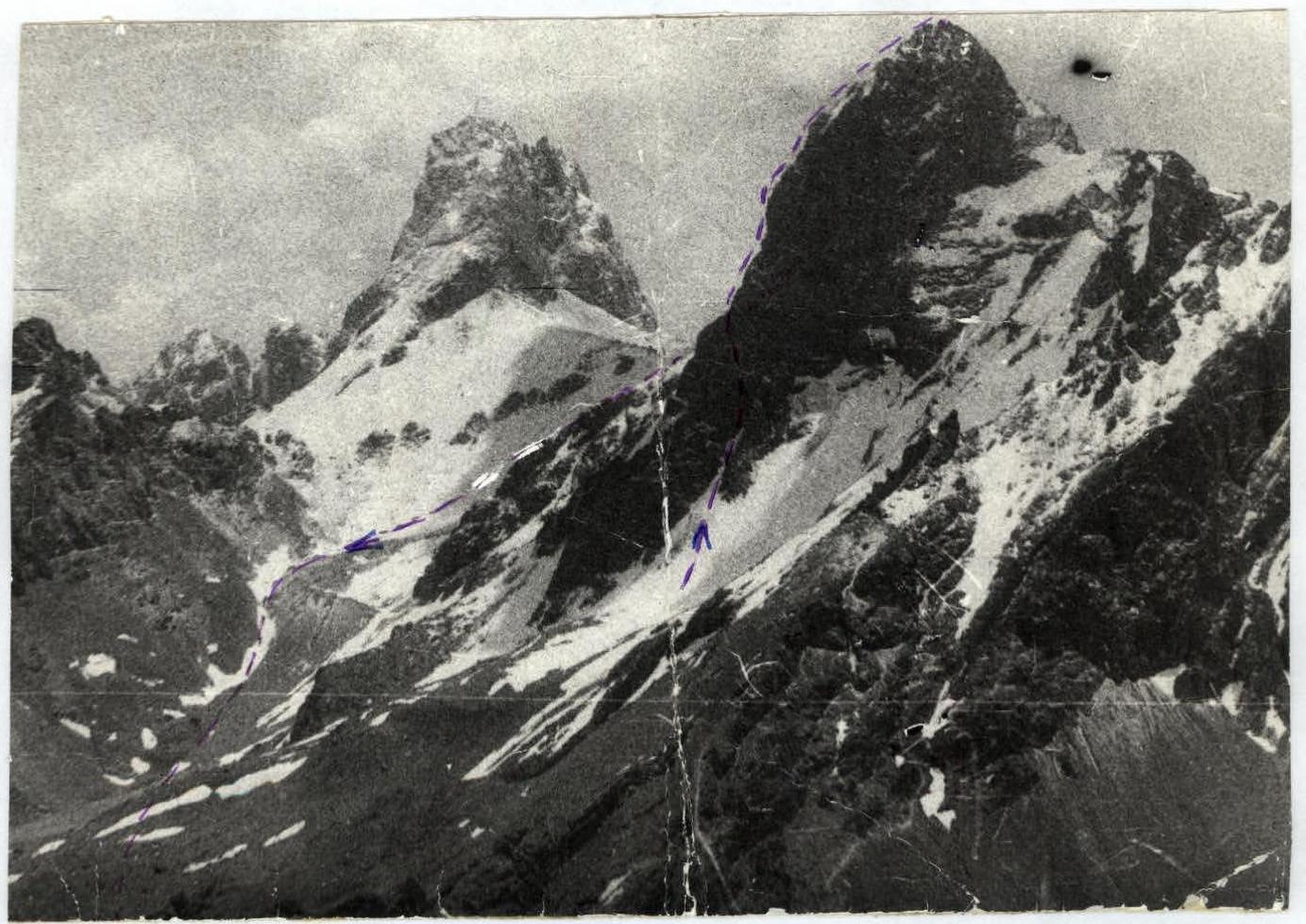
General View of the Summit
(Frontal photo. Taken from the summit of Patrush)
General View of the Summit
(Taken from the summit of Surkh)
Saroch peak, Peak "Independence"
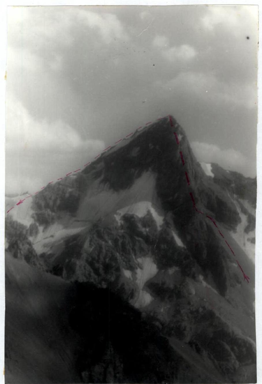
Technical Photo of the Summit
"Key section" of the route
Start of the route
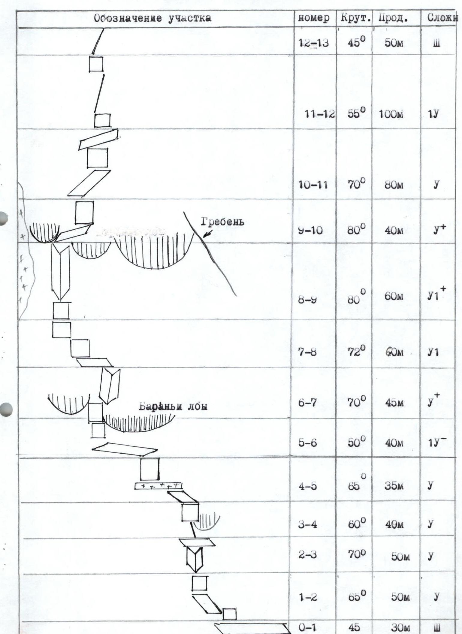
Route Description by Sections
The approach from the base camp, located by the lake, takes 1 hour. The route begins on the right side of the edge. Without reaching the base of the edge, ascend along the glacier and a steep scree for 100 m. The scree turns into a couloir. Before reaching the couloir, move left along the ledges towards the brown sheer rocks.
Connect on a ledge at the beginning of a pronounced crack crossing the rock mass from right to left.
The length of the wall section of the route is 660 m.
Section R0–R1:
- Move left along the ledge for 30 m on easy rocks.
- Reach the internal corner.
Section R1–R2:
- Steep wall 8 m, turning into an internal corner — a ledge 25 m long.
- Further, a complex steep section leads to a place convenient for belaying.
Section R2–R3: From the ledge, move up, bypassing the overhang on the left. Long internal corner.
Be cautious due to:
- "Live" stones.
Section R3–R5: General direction of movement is up and left, leaving sheer rock "gendarmerie" on the right. The length of the section is 80 m. There is a 10 m ice section. It is passed on the right under the cornice. This section leads under the overhang to an inclined ledge.
Section R5–R6: Along the ledge, left and up, bypass the overhang — the "ram's forehead". Reach a destroyed sheer wall. Up 10 m of complex climbing, belaying is difficult to organize. Reach monolithic rocks.
Section R6–R7: On monolithic rocks, up and to the right along the crack. Cracks are filled. In the upper part of the ropes, there is a series of cracks where a belay point is organized.
Section R7–R8: Left along a complex wall, bypass the ridge and move right and up. 20 m along a series of walls, without reaching the ridge, move left along the edge and enter the cirque of a powerful rock bastion. From here begins the most complex section of the route. The entire massif seems to overhang.
- On the right, a ridge with monolithic sheer rocks is visible. The lack of cracks in this part does not allow for free climbing.
- On the left, the massif is bounded by an icy couloir and accreted ice. The ice is hidden behind a rock ridge.
Move up, crossing the cirque to the left in the direction of a pronounced dark crack. Climbing is complex.
Section R8–R9: Up along the crack. Very complex climbing. There are few cracks. Climbing is artificial at the exit. Having passed the overhang, reach a counterfort.
Section R9–R11: Right and up along a series of ledges and walls, bypassing the main ridge massif on the left. Reach the ridge.
Section R11–R12: Along the ridge, without reaching the rock gendarmerie, reach the pre-summit part of the route.
Section R12–R13: Along an easy ridge, reach the summit.
If there is ice climbing equipment, descent from the summit is possible along the Northeast Ridge (2B category of difficulty) in the direction of Saroch peak to the Upper Zinakh Pass. In this case, the group descends towards their assault camp. The descent takes 3.5–4 hours.
In the absence of ice climbing equipment, descend from the summit along the Southwest Ridge (3A category of difficulty). This descent option is shorter, taking 2.5–3 hours, but leads to the Lower Zinakh Pass, and the group does not return to their assault camp. It takes another 2 hours to walk from the pass to the base camp. Therefore, it is advisable to have assistants whose task is to set up a camp on the Lower Zinakh Pass.
UIAA ROUTE SCHEME