Ascent Passport
- Sports organization — MGS DSO "Spartak".
- Ascent category — technical.
- Ascent area — Fann Mountains, Pamir-Alay.
- Peak, its height, ascent route — peak Jinatar 4400 m, north-eastern ridge.
- Ascent description: a) height difference 700 m. (III cat. diff. — 490 m, IV cat. diff. — 270 m, V cat. diff. — 260 m); b) average steepness 65°.
- Pitons used: for belaying — rock 90, ice —, bolted —; for creating I.T.O. — 5.
- Total climbing time: 11 hours.
- Tactics — rope-team movement, first climber without a backpack.
- Team members: a) Sadovnikov Vladimir Georgievich 1952, 1st sports category, Moscow, Baykalskaya 40/17, apt. 199; b) Ponomarenko Yuri Vladimirovich 1946, 1st sports category, Moscow, Zhivopisnaya 4, bldg. 3, apt. 54.
- Team coach — Martynovsky A. L.
- Departure and return date — August 7, 1976.
 To the ridge
Brief geographical description of the area and ascent conditions
The Fann Mountains are located on the territory of Tajikistan between the Gissar and Zeravshan ranges.
In the complex orography of the Fann Mountains, two main (latitudinal) ridges can be conditionally identified — the Northern, branching off from the Zeravshan range, and the Southern, stretching from the Fan-Darya gorge in the east to the Dukdon massif in the west. The ridges are connected by a short isthmus with the nodal five-thousanders Mirali and Energiya; the isthmus is home to the highest peak of the Fann Mountains — Chimtarga (5487).
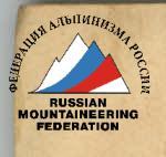
The Southern ridge is home to most of the main peaks of the Fann Mountains: Big and Small Ganza, Energiya, Bodkhona, and Chapdara (in the northern spur of the S. ridge), Zindon, Skalnaya Stena, Moskva, Amshut (in the N.W. spur), Sakharnaya Golova, Arg, Zhinoatar, and the Dukdon massif.
The orography of the Fann Mountains dictates their division into climbing areas:
- Southern or Arg area with a base at the clearing at the confluence of the Arg-Akhbasoy rivers.
- Central — the largest area with bases on the Alaudin or Mutny lakes.
- North-Western — the Artuch tourist camp area.
- Western — with a base on Bolshoe Allo lake.
- South-Western — with a base under the Northern slopes of the Dukdon massif.
The Pamir-Alay ridges are composed of sedimentary and metamorphic rocks (crystalline schists, marbles) with local inclusions of igneous rocks — granites, diorites, etc.
There is a great diversity of landforms created by mountain rivers and glaciers (morainic formations).
The climate of the Fann Mountains, remote from seas and oceans, is continental with low annual precipitation — 250 mm.
Summer is hot, almost without precipitation. Winter is cold, with frosts. The snow line is at an altitude of about 3500 m. There are about 40 glaciers in the Fann Mountains. Almost all of them are located in the northern part of the mountains. Most of the glaciers have a steep drop.
The largest river in the area is the Iskander-Darya with a forty-meter waterfall. There are many dammed lakes in the area.
The mountains are rich in various minerals, and rare metals are found.

| Date | Section | Steepness | Length | Relief | Difficulty | Condition | Pitons (rock) (driven) | Pitons (ice) (driven) | Pitons (bolted) (driven) | Passage (rock) | Passage (ice) | Passage (bolted) | Time (climbing hours) |
|---|---|---|---|---|---|---|---|---|---|---|---|---|---|
| 7.8 | R0–R1 | 30° | 50 m | diagonal s- | 3–2 | monolith | 1 | – | – | simultaneous | – | – | – |
| R1–R2 | 60° | 80 m | ridge | 4 | monolith | 10 | – | – | alternating | – | – | – | |
| R2–R3 | 40° | 30 m | slab-plate | 4 | monolith | 4 | – | – | alternating | – | – | – | |
| R3–R4 | 80° | 60 m | wall, slab | 5 | monolith | 8 | – | 1 | fixed rope, alternating | – | – | – | |
| R4–R5 | 45° | 20 m | rocks | 3 | broken | 1 | – | – | alternating | – | – | – | |
| R5–R6 | 60° | 30 m | slab | 5 | monolith | 1 | – | 2 | alternating | – | – | – | |
| R6–R7 | 65° | 80 m | rocks, slabs, walls, cracks | 3–4 | broken | 5 | – | – | alternating | – | – | – | |
| R7–R8 | 45° | 30 m | slab | 4 | monolith | 4 | – | – | alternating | – | – | – | |
| R8–R9 | 80° | 40 m | wall, eaves | 5, 4 | monolith | 8 | – | 1 | fixed rope | – | – | – | |
| R9–R10 | 75° | 30 m | wall, inner corner | 5 | monolith | 5 | – | – | alternating | – | – | – | |
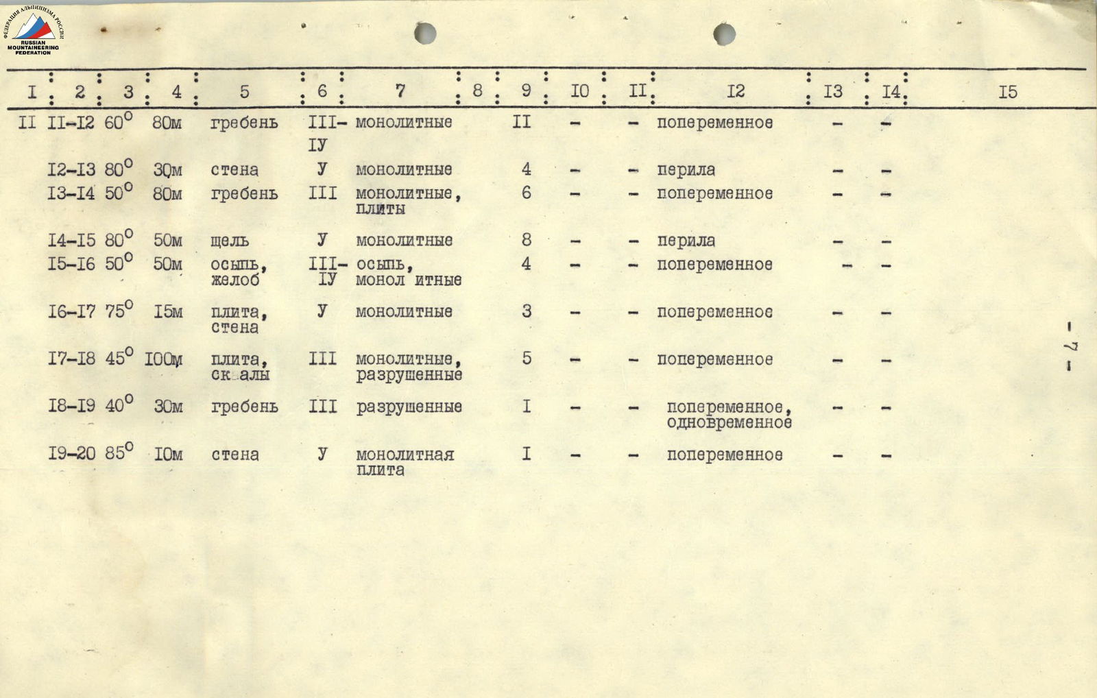
| R11–R12 | 60° | 80 m | ridge | 3–4 | monolithic | 11 | – | – | alternating | – | – | – | |
| R12–R13 | 80° | 30 m | wall | 5 | monolithic | 4 | – | – | fixed rope | – | – | – | |
| R13–R14 | 50° | 80 m | ridge | 3 | monolithic, slabs | 6 | – | – | alternating | – | – | – | |
| R14–R15 | 80° | 50 m | crack | 5 | monolithic | 8 | – | – | fixed rope | – | – | – | |
| R15–R16 | 50° | 50 m | scree, groove | 3–4 | scree, monolithic | 4 | – | – | alternating | – | – | – | |
| R16–R17 | 75° | 15 m | slab, wall | 5 | monolithic | 3 | – | – | alternating | – | – | – | |
| R17–R18 | 45° | 100 m | slab, rocks | 3 | monolithic, broken | 5 | – | – | alternating | – | – | – | |
| R18–R19 | 40° | 30 m | ridge | 3 | broken | 1 | – | – | alternating, simultaneous | – | – | – | |
| R19–R20 | 85° | 10 m | wall | 5 | monolithic slab | 1 | – | – | alternating | – | – | – |
Route description
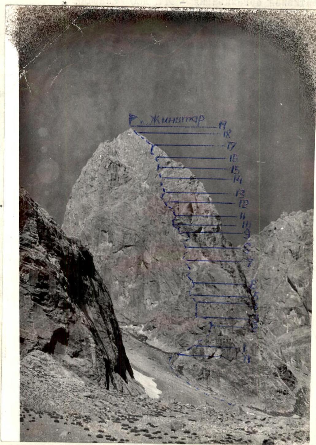
August 7, 1976. From the base camp at the TEPA clearing along the right bank of the river flowing into the Akhbasoy river and further along the left side of the Akhbasoy river. Crossing the river opposite the scree couloir to the left of the N.E. ridge of Jinatar peak. Then up the couloir to a diagonal slab cutting through the S.W. wall.
Section R0–R1 (50 m, 30°). Up and to the right along the diagonal slab (a slab-like ledge covered with stones).
Section R1–R2 (80 m, 60°). Then along the ridge — monolithic rock walls and slabs on both sides — to a large grey slab.
Section R2–R3 (30 m, 40°). Under the slab, traverse right along a slab-like ledge, moving on friction.
Section R3–R4 (60 m, 80°). Then up the wall through an overhang with a ladder and along a slab to reach rocks of medium difficulty.
Section R4–R5 (20 m, 45°). Along rocks of medium difficulty to the edge of a slab and then down and to the right to a control cairn.
Section R5–R6 (30 m, 60°). From the control cairn, up and to the left, bypassing a yellow broken slab. Very difficult climbing.
Section R6–R7 (80 m, 65°). Then along rocks representing a system of walls, slabs, and vertical cracks. The entire section is prone to rockfall.
Section R7–R8 (30 m, 45°). Under the black rocks, a cautious traverse to the right along a small ledge-slab (friction) to the junction of the black and yellow rocks.
Section R8–R9 (40 m, 90°). From here, difficult climbing up the wall through two two-meter eaves and then onto a scree ledge under a huge yellow rock.
Section R9–R10 (30 m, 75°). From the ledge, up a wall and then along an inner corner to a small ledge.
Section R10–R11 (20 m, 70°). Then along the inner corner turning into a crack, exit onto the ridge. Then the path goes along a monolithic ridge and further to the right and up onto a broken ledge with some scree.
Section R12–R13 (30 m, 80°). From the scree, up a monolithic wall to reach the ridge again. Climbing is difficult.
Section R13–R14 (80 m, 50°). Along the ridge, rocks of medium difficulty lead to a wall with an inclined crack.
Section R14–R15 (50 m, 80°). The inclined crack is traversed with difficult climbing using I.T.O. The crack again leads to the ridge.
Section R15–R16 (50 m, 50°). Then traverse the scree to the right and ascend a steep groove to slabs.
Section R16–R17 (15 m, 75°). Along the slab and a sheer wall to reach easy rocks.
Section R17–R18 (100 m, 45°). Along easy rocks to a sub-summit consisting of several huge stones.
Section R18–R19
Along a small ridge to the summit. The summit itself is a stone pyramid. The ascent is quite difficult as it is hard to organize belaying on the monolithic slabs.
Descent to the south through a crack between the summit and the sub-summit. Bypass the summit tower on the left and exit onto the S.W. ridge. Overnight stay is possible between the first "gendarme" and the summit.
The first "gendarme" is bypassed on the right. Then descent along a slab under the second "gendarme" in a sport climbing style. The descent from the S.W. side begins into the S.W. ridge col. Three rappels and sport climbing. From the col, 40 minutes down the scree to the Akhbasoy river.
The descent includes: — three rappels; — a sport climbing section.