To the Classification Commission
Moscow City Council of the Spartak Volunteer Sports Society
Ascent to peak "Vilnius" via the 3rd wall, made by the team of Moscow City Council of the Spartak Volunteer Sports Society via route 4B cat. difficulty
Pamir-Alay
Fann Mountains, Arg gorge
August 1976
I. Characteristics of the region and the object of ascent.
The mountain system that includes the Fann Mountains occupies an intermediate position between Tian Shan and Pamir and is called the Pamir-Alay. Ongoing mountain formation processes lead to significant folding disturbances. The actions of water and wind exacerbate these disturbances. All of this together affects the terrain. A large difference between winter and summer temperatures affects the formation of cracks.
The ridges of the Fann Mountains have many walls reaching a height of two kilometers, canyons, and towers. The mountain crests abound with gendarmes and weakly fixed large blocks.
Interestingly, each peak of the Fann Mountains has its own distinctly different "individual face".
In the closed valley of the Fann Mountains, it is sunny, there is little precipitation, winds do not penetrate, and bad weather is short-lived.
The "Akbasay" gorge, in the upper reaches of which most of the ascents of the Moscow City Council of the Spartak Volunteer Sports Society team took place, is locked by the peaks "Sakharnaia golova" and "Moskva". Further from the confluence of the "Akbasay" and "Pushnovat" rivers, the right side of the gorge is cut off by the dark walls of the ridge formed by peaks "Vilnius", "Zhinotar", and "Arg".
Peak "Vilnius", along whose western wall the route is laid, drops steeply to the north and west with walls 400–500 m high, and to the south, through a ridge with the "Zverinyi" pass, it connects to the Zeravshan ridge.
II. Group composition.
- Lupikov A.F. – 1st sports category, leader
- Stepanov V.A. – 1st sports category
- Medvedev Yu.L. – 1st sports category
- Tinin Yu.P. – 1st sports category
III. Description of the route.
Overnight stay near a large stone at the confluence of the "Pushkovat" and "Akbasay" rivers. Departure from the overnight stay at 6:30, under the route at 7:00.
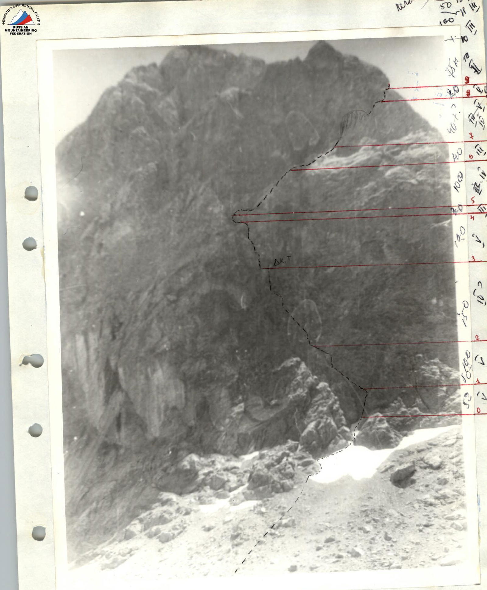
The route begins in the middle of the base of the wall from a snowpatch that emerges from the angle formed by a triangular break and an internal angle forming a "V" shape.
Section R0–R1. Directly from the base of the snowpatch, a chimney with two corks goes to the right. Chimney 40 m, width up to 0.5 m. Go without backpacks (pitons, difficult climbing). The chimney ends with a platform, from where 12 m up to the left is a place for pulling up backpacks (60 m rope, pitons). The rope is thrown down by an observer.
Section R1–R2. From the backpack pull-up site, the route goes up to the left into an internal angle with a crack. Up the crack to a platform. The crack is smoothed out at the top, and holds are thrown off. The first person goes without a backpack (pitons, difficult climbing).
Section R2–R3. Up to the left along a narrow steep ledge, we approach steep rock slabs (75–80°) with a crack (pitons, difficult climbing). After passing the slabs, we exit onto a large horizontal ledge (control cairn).
Section R3–R4. In the left part of the ledge, there is a horizontal crack with an overhang. The path goes through the crack (wedge, pitons, ladder, difficult climbing). In the upper part of the crack, there is a 3 m move to the left along a small shelf (protection on a выступ) and up a steep destroyed slab (75°, pitons, difficult climbing) into an internal angle.
Section R4–R5. Further to the left along a ledge with large stones into the angle of a large mountain triangle on the wall (30 m, protection on a выступ).
Section R5–R6. Up to the right along a ledge with a выступ (10 m) onto a steep slab (70°). Traverse the slab further up onto a steep rock inclined ledge (60°, pitons).
Section R6–R7. Up along the ledge for 40 m to the lower base of a couloir (loose stones, moderate climbing).
Section R7–R8. The couloir leads to a snowpatch between the wall and a "finger". On snow to the upper base of the snowpatch above a rock cork. The cork is passed directly (difficult climbing), from where there is a 6 m inclined wall (pitons), which leads to large stones (40 m) under a slab forming a crack with the wall on the left (pitons, moderate climbing).
Section R8–R9. Vertical crack 3.5 m. Passed with a ladder and pulling up on a piton. Protection through wedges in a horizontal crack under the slab (wedges, pitons, ladder, difficult climbing). 15 m after the crack, the route exits onto a platform. Pulling up backpacks (loose stones).
Section R9–R10. From the platform along ledges, there is a 40 m traverse to the base of a chimney (75 m).
Section R10–R11. The chimney is passed to the first cork inside. Further to the right onto an outer wall (monolith 75–80°, few crack for pitons, 40 m). Wide lateral crack. Place for reception. Further up, bypassing the cork hanging over the crack on the right and again into the upper part of the chimney (15 m), along the chimney 25 m to the shoulder of the ridge (pitons, moderate climbing, loose stones).
Section R11–R12. Further, the path goes along the ridge. Three ascents (slabs, moderate climbing, pitons). 150 m along easy destroyed rocks. Further onto a saddle between the peak and a large gendarme, we exit onto a pre-summit ridge. 400 m along a destroyed ridge and small snowfields to the summit. On the summit at 17:30.
Descent towards the "Zverinyi" pass and along scree to the "Pushkovat" river and to the overnight stay (45 m).