
I
1. Class — rock climbing.
- Pamir-Alay, Fann Mountains — southern part (5.3.D.).
- Ascent to peak Arg via the right bastion of the north face.
- Complexity category — 6B, first ascent.
- Height difference — 1150 m, with 560 m of wall section. Total length — 720 m, with 235 m of difficult section. Average steepness of the wall section — 72% (3060–3620 m).
- Pitons and other equipment used:
| rock | stopper | skyhook | bolt | lodged | fixed camming device | other | |
|---|---|---|---|---|---|---|---|
| Total | 201 | 80 | 87 | 8 | 22 | 2 | 2 |
| During | 23 | 6 | 4 | 8 | 5 | — | — |
| P.T.O. |
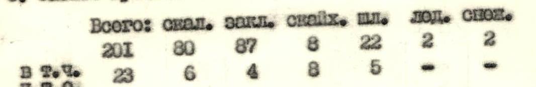
- Climbing hours — 47, days — 5.
- Overnight stays at points 10, 14 — sitting, at point 20 — semi-reclined.
- Team leader — Gennadiy Anatolyevich Starikov, Candidate Master of Sports.
Team members:
- Aleksandr Georgiyevich Vasilyev, Candidate Master of Sports
- Aleksandr Vladimirovich Katsapov, Candidate Master of Sports
- Oleg Matveyevich Solovey, Candidate Master of Sports
- Yevgeniy Petrovich Stepanov, 1st sports category
- Coach — Nikolay Nikolayevich Goluchev, Master of Sports of the USSR, deputy head of "Artuch" climbing base.
- Departure on July 5, 1985, summit reached on July 9, descent on July 9.
- Organized by "Artuch" climbing and sports base.
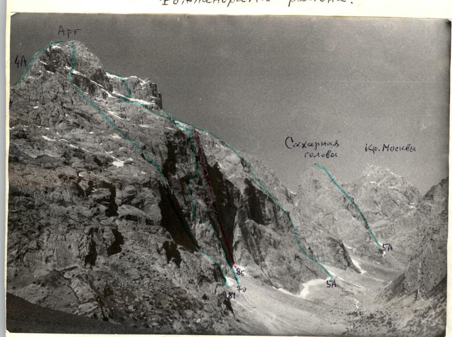
Brief notations on photos:
- A — overnight stays
- -- 1979 variants
- — routes of 1981 (Glushko), 1970 (Malogo), 1984 (Skachkova)
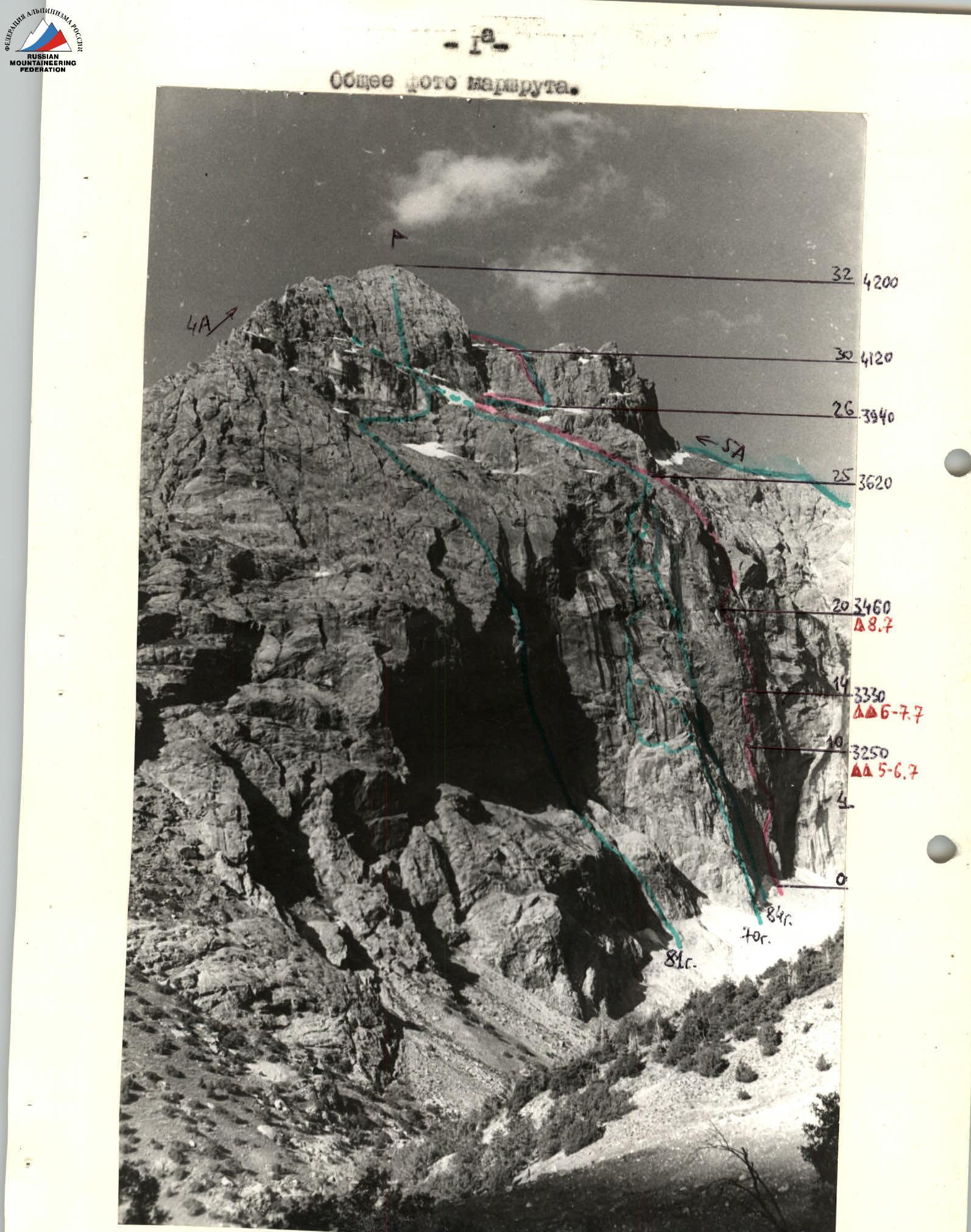
Photo #1. Taken on III-80 in the morning. 1:50, 2.8/50, T. 1. Height 2690 m, distance 3 km.
Profile photo of the wall section of the route from the left.
Photo #2. Taken on I-84 in the morning. 10–11, 4/135, T. 1. Height 2690 m, distance 3 km.

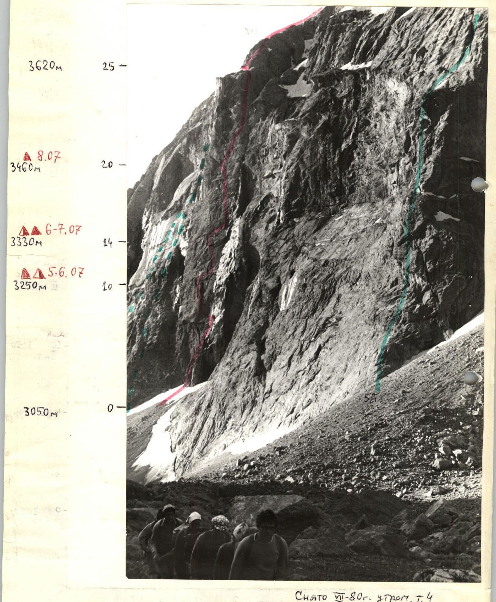
Profile photo of the wall section of the route from the right. Photo #3. Taken on III-80 in the morning, T. 4. 1:50, 2.8/50, height 3100 m, distance 2 km. Notations:
- -- Routes of 1970, 1984
- — route of 5A category
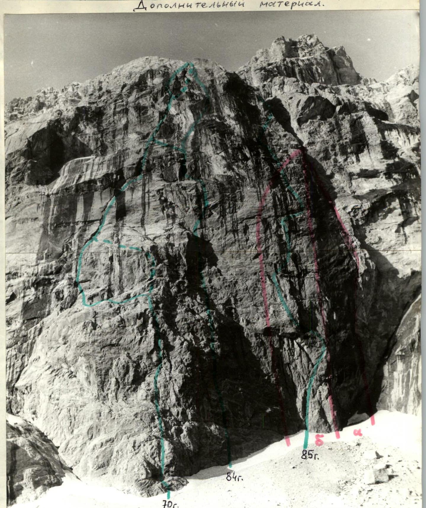
Additional material.
Photo #5. Taken on III-85 in the morning, T. 2. Ge-44, 2/58. Height 2800 m, distance 1.5 km. Notations:
- -- 1979 variants
- — routes of 1970 (Malogo), 1984 (Skachkova), 1985 (Starikov)
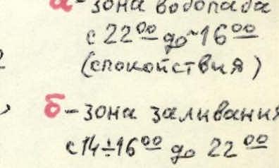
- a — waterfall zone from 22:00 to 16:00 (calm)
- b — flooding zone from 14:00 to 22:00 when wind changes in Akhbasoy gorge
Panorama of the area.
Photo #4. Taken on III-85, T. 1. Ge-44, 2/58. Height 2960 m.
Brief overview of the ascent area.
Peak Arg is located in the southern part of the Fann Mountains (Pamir-Alay) at the confluence of the Kaznok and Akhbasoy rivers. The area has been known for a long time.
Approach:
- bypassing Lake Iskanderkul, through the village of Kanchoc to Sarytog. 3.5 hours walk along the Arg gorge trail to "Tenshy" and another 1 hour to the route.
- If approaching from the Alaudin lakes via Kaznok pass, the journey takes 7–8 hours.
The north face of Arg is oriented in a semi-profile towards the base camp of the "Varzob" tourist center under Teta. Many groups of climbers, walking along the Akhbasoy gorge trail under Arg, are amazed by the uniqueness of the north face.
The history of climbing the face is interesting. In 1970, the first route was laid "through the gap" (A. Maly+3) in 7 days. The third ascent was in 1978. The next year, climbers from Dnepropetrovsk (N. Petrichenko) passed it with some variations, still with 2–3 overnight stays, and in 1980, it was first climbed with 1 overnight stay by a team from the Moscow Regional Council.
In 1971, a team from Voronezh (I. Borodatskiy, V. Rublev+2) attempted to climb the left bastion but gave up after 2 days of work. This route was completed by V. Glushko — V. Balyberdin 10 years later (their report exaggerated the height difference and average steepness of the bastion).
In 1984, two teams entered the championship of Central Asia in the rock climbing category on peak Arg via the north face:
- The "Artuch" team returned from halfway through the route on the right bastion in early July, having worked for 4 days (from point 15 — see photo);
- The KSP team in the Tajik SSR completed the route along the bend of the north face in late August, rating their route as 6th category (see notes taken).
Climatic conditions in the area are typically dry, known as "greenhouse conditions", so our 1985 route on the right bastion introduces a correction: the presence of "Bezengi weather" — mandatory afternoon rain showers from the right waterfall.
The route is psychologically challenging, requiring a synthesis of experience, endurance, and excellent technical preparation, especially for rock climbing.
Tactical actions of the team.
Considering all the information from the preparatory period and observations of the route, a tactical plan was developed to ensure the team's safety.
The route starts without prior processing.
Work on the bastion is possible for no more than 7–9 hours a day, as from 14:00 to 16:00, the route is flooded with water until 21:00–22:00: rain from the waterfall. The route dries again overnight.
Safe overnight stays are only available at points 10, 14, and 20 under overhangs. The lead climber can just make it to the next section before the rain starts, while the others follow on the fixed ropes, taking cover under tarps. Further processing of the route is impossible.
There are also difficulties in collecting water, as the team must stay under plastic cover at the bivouac and be resourceful in collecting water:
- 6 additional containers were brought,
- along with bandages.
Hot meals were prepared at overnight stays in the morning and evening, with each participant receiving an individual ration for the day. The team had two first-aid kits: one with the 2nd participant and the main one with the 4th participant.
Due to the complexity of the route and the impossibility of spreading out, the team decided to manage with 5 ropes, forgoing the 6th (for 5 people). Movement on the route followed standard tactics for wall climbing:
- the lead climber worked without a backpack using a shock absorber on a double rope (one of which was always fixed — from FRG);
- the second climber used a Sticht plate for belaying (sections R1–R25, R26–R29);
- the other participants ascended on fixed ropes without removing their backpacks, using a "chest-leg" method with jumar clamps and top-rope belay or on double fixed ropes with 3 clamps.
The second and third climbers straightened the fixed ropes, removing all intermediate pitons. The last climber organized the retrieval of the fixed rope on long pendulums (7 times) for safety.
Belay stations were set up on only 3–4 points, including bolted pitons. The route is very steep with sections of extreme climbing on vertical monoliths with micro-ledges, sometimes needle-like (especially sections R15, R16, R17).
The problem of the north face of Arg is passing the right bastion on its left side from the edge. Key sections are marked in the table as U+, U1.
The main technical challenge was resolved by passing sections R15–R19 before the rain started (the last two sections were still caught in the rain).
All special equipment was used on this section: skyhooks, bolted pitons for belaying, with minimal use. The extremely difficult section R11–R14 spanned 2.5 ropes. There were no falls or injuries. Lead climbers were rotated daily:
- Day 1 — Vasilyev–Katsapov;
- Day 2 — Katsapov–Solovey;
- Days 3–4 — Vasilyev–Solovey;
- Day 5 — Katsapov–Solovey. On the 3rd day, the key section of the route was actually processed. This was a deviation from the tactical plan by exactly 1 day. On the 2nd day, the rain came in uneven bursts.
When the lead climber reached the second overnight stay, the first burst of PPН sounded, and three participants had to urgently return to the first overnight stay. During a lull, the first two descended to them.
The rain continued, but it was not possible to collect much water as on the first day — there was not enough water.
At 15:00, Starikov and Stepanov ascended on fixed ropes to the second overnight stay to collect water and meet the trio with tea in the morning, which was accomplished.
The route was completed by the team in an organized and technically sound manner. Radio communication was maintained with the MBS team (Demchenko A. S., Fyodorov O. K.) on Toppa in direct line of sight using a "Komar" radio set, with simultaneous observation of the team's work on the route.
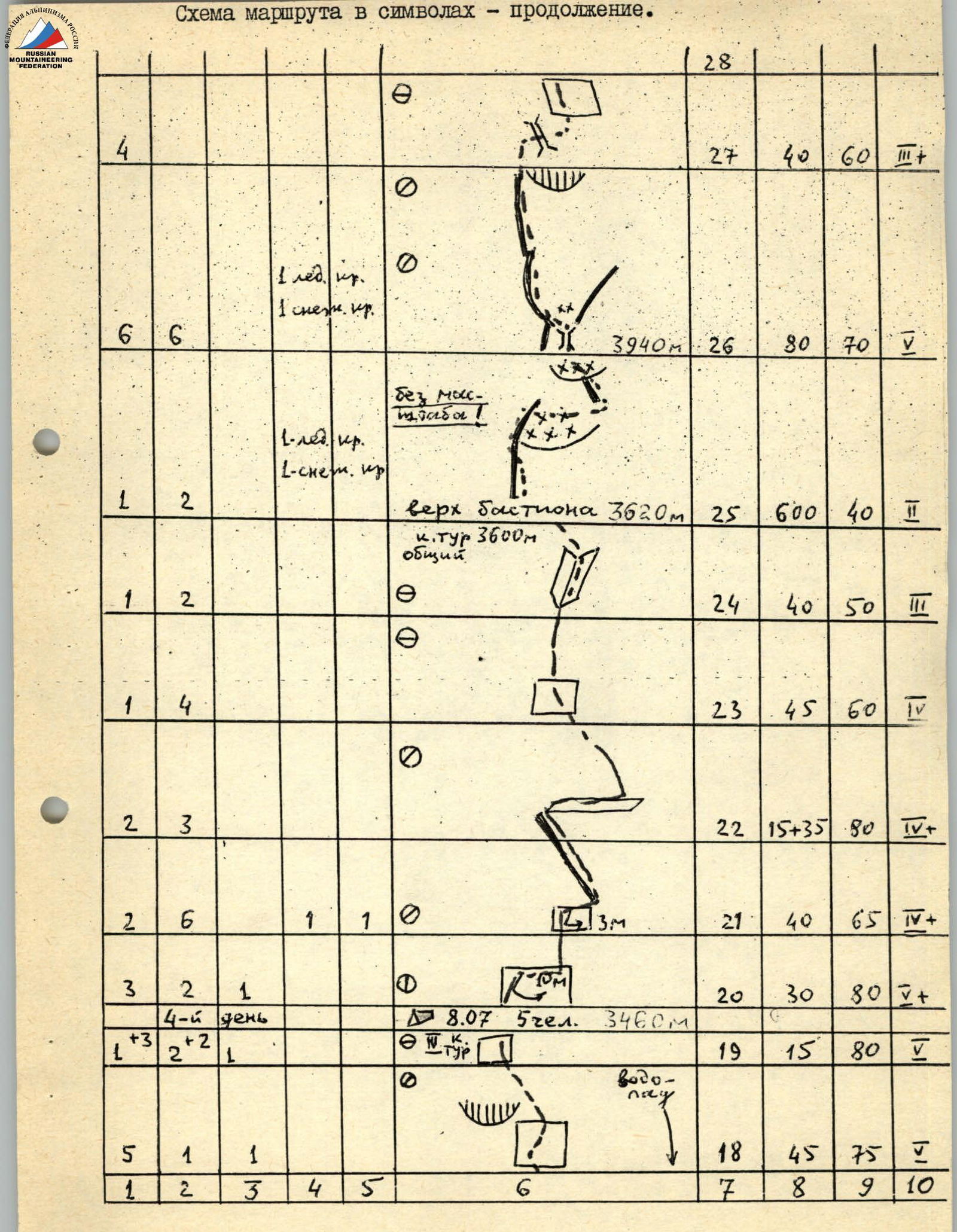
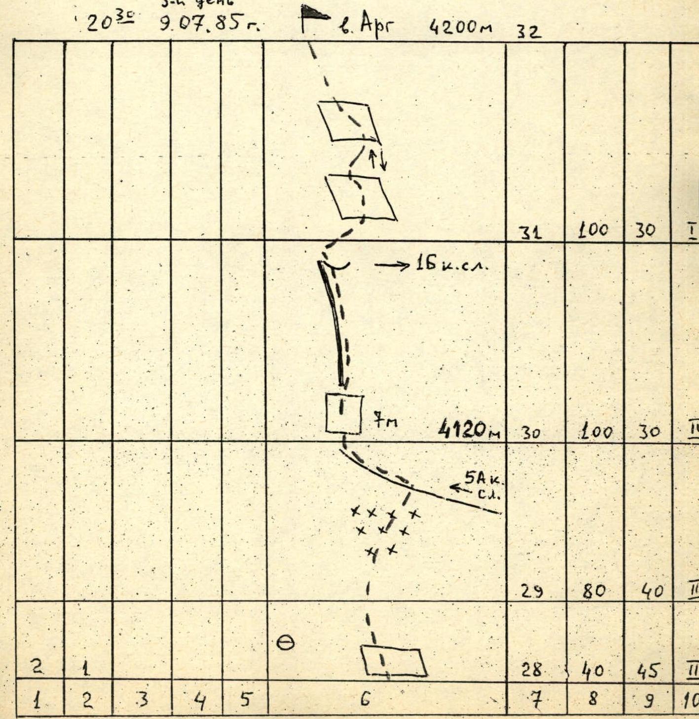
Diagram of the route in symbols (M 1:2000).
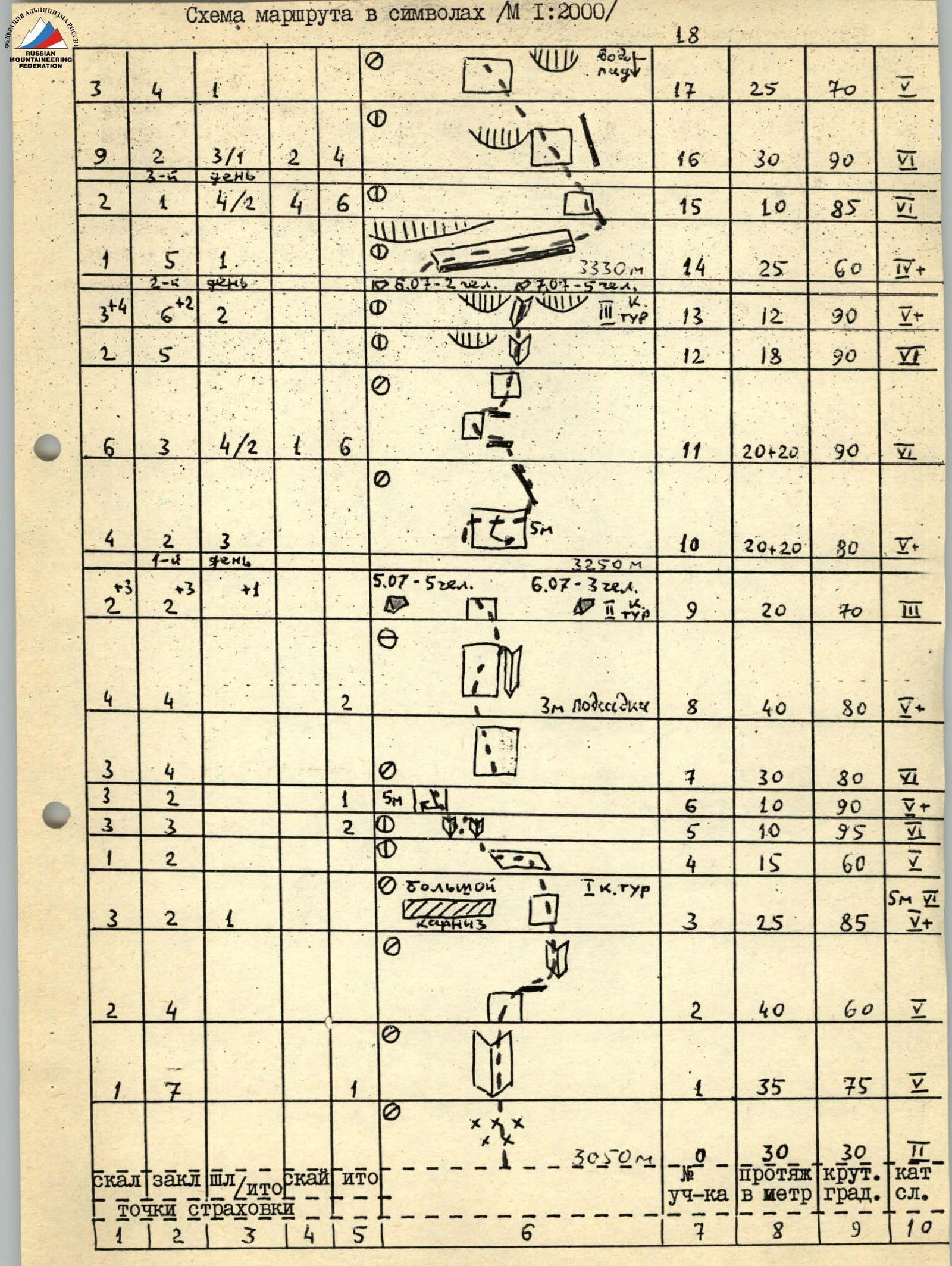
Continuation of the route diagram in symbols.
Description of the route by sections.
- R1–R4: monolithic rocks, dampness in cracks, inclined ledge is traversed on friction, very difficult on R3–R4! 1st category belay on a bolted piton.
- R4–R5: traverse left on a slab on friction, micro-ledges to a vertical crack. The last in the group retrieves the rope.
- R5–R7: up the crack, traverse left, pendulum, very complex maneuvers, exit to a ledge, belay station in a hang, last one retrieves the rope.
- R7–R8: wall, micro-ledges, very difficult, slightly left, descend, then up.
- R8–R9: initial 3 m are aided by a foothold, up the wall to an internal corner.
- R9–R10: some "live" rocks; overnight stay on the left under an overhang, 2nd category belay on a bolted piton. Water was collected from the rain shower.
- R10–R11: descend, traverse right for 20 m (with a pendulum) — last one retrieves the rope, up to a "ridge". Extremely difficult.
- R11–R14: right along a ledge for 20 m to rusty rocks, left-up extremely difficult, belay station in a hang; up vertical internal corners with cracks, exit left to the top of a 3-tiered ledge, climbing at the limit. Caution! there's a "live" flake. 3rd category belay on a rock piton. Water was collected with bandages.
- R14–R15: traverse right along a crevice under a roof for 20 m, very difficult at the end, descend slightly — exit to a ridge, belay station in a hang. Last one retrieves the rope.
- R15–R16: extremely difficult: micro-ledges, "needle-like", vertical. Waterfall is nearby on the right. Belay station in a hang.
- R16–R17: same, move slightly left.
- R17–R18: up to a placement with an "irbis" (left by a group), left-up, belay station in a its hang, last one — with rope retrieval. The last participant was caught in the rain shower from the waterfall!
- R18–R20: difficult climbing up-left, maneuvering between overhangs, belay stations are inconvenient, in a hang. 4th category belay. Overnight stay on a made semi-platform on the left under an overhang. Not much water was collected.
- R20–R21: very difficult! pendulum, traverse right-up, belay station in a hang, last one — with rope retrieval.
- R21–R22: difficult exit up and pendulum right to a ridge, up its right side.
- R22–R25: don't relax! close to the top of the bastion, many "live" rocks, careful climbing on the right part of the bastion to its top. To find the common control belay, descend from this point down-right on scree and snowpatch for 80 m. Water and rest are available here.
- R25–R26: in pairs on a shortened rope, initially up an internal corner of 3rd category difficulty for 60 m (fixed rope for 40 m). Then up a ridge of "ram's foreheads" to the summit tower. On the right, a U-shaped couloir is visible (see photo); the approach to it is: crossing the lower snowpatch right on wet scree, gaining height. Up a firn slope to the chimney start of the U-shaped couloir. Up the chimney (fixed rope) — to the top, belay station under an overhang on the right.
- R26–R27: rock counterfort, difficult climbing, monolith.
- R27–R28: traverse the couloir right, last one — with rope retrieval. Up steep slabs, crumbling.
- R28–R29: slabby section.
- R29–R30: scree, snowy slope, exit to the ridge of 5A category.
- R30–R31: rocky ridge, large snow cornices on the left.
- R31–R32: slabs, "ram's foreheads", exit to the summit, descent back to the col #31.
Descent is via the 1B category route into the Arg gorge.
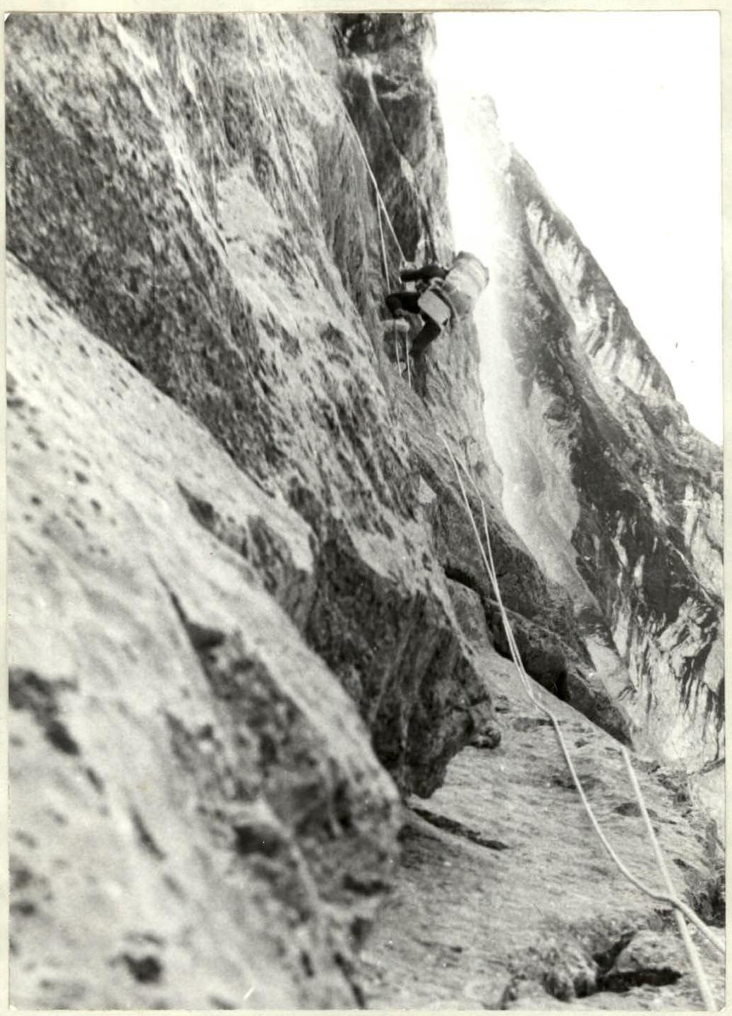
Photo #6. Passage of section R2–R3.
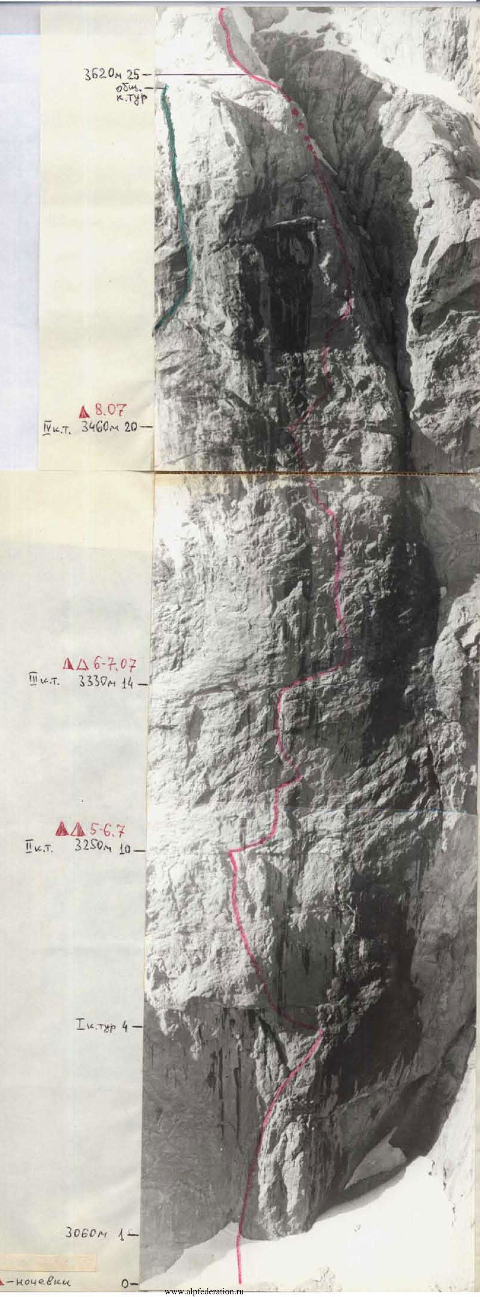
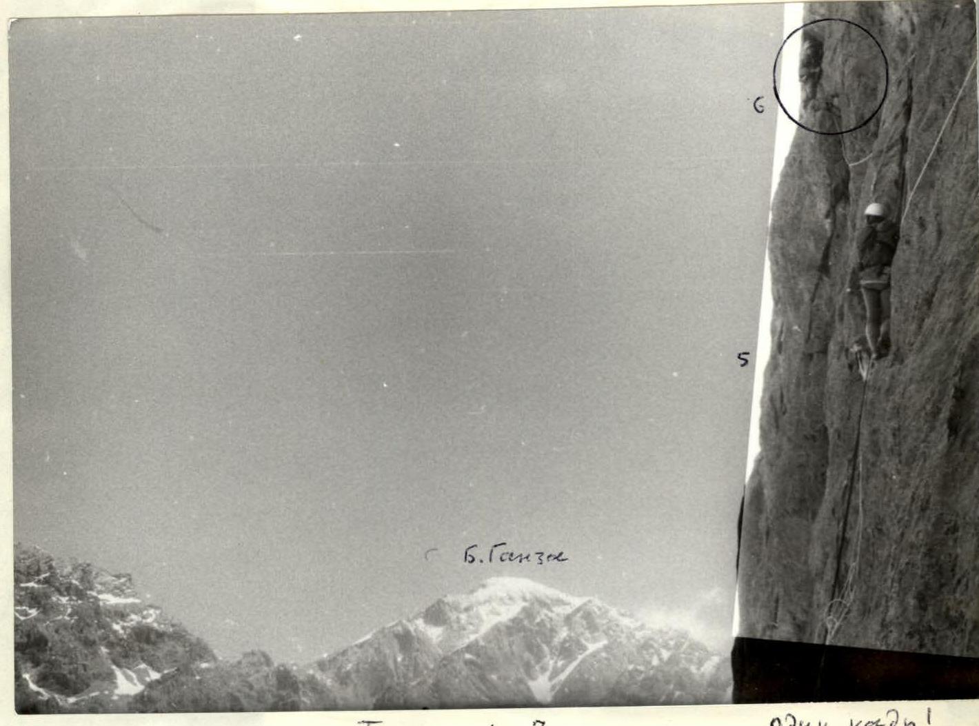
Photo #7. Passage of sections R5–R6. Taken from point 4.
Photo #8. Sections R10–R11.
