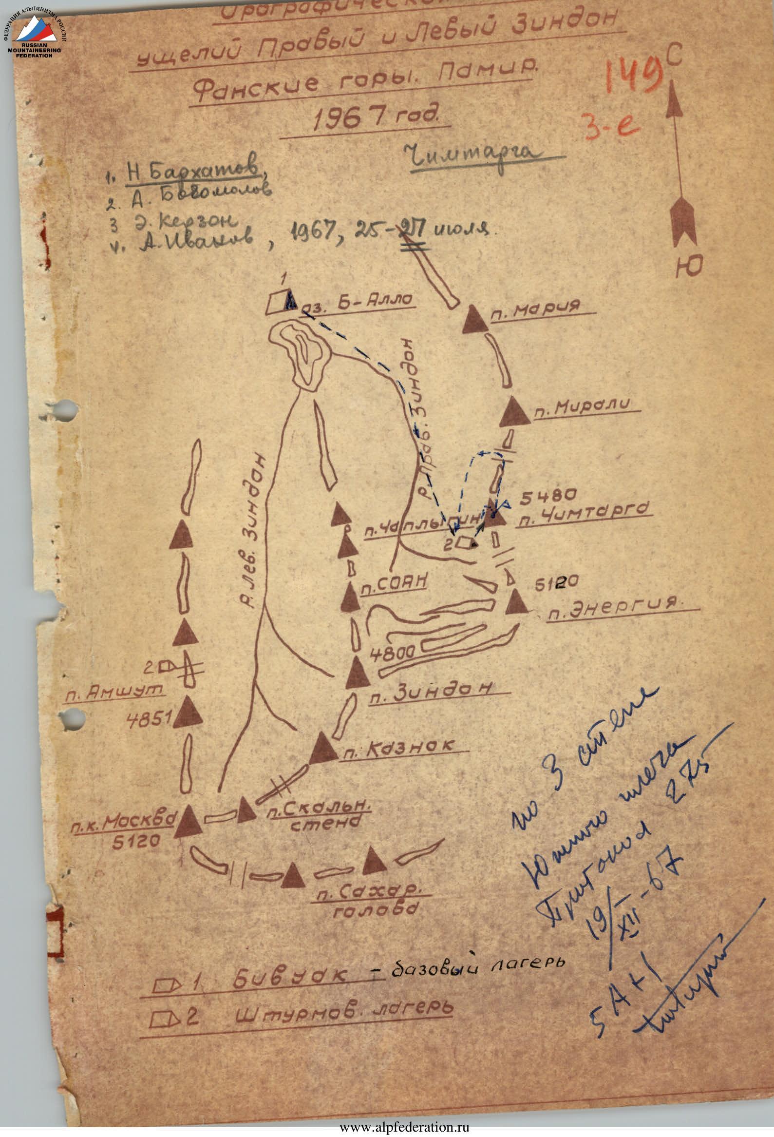
Route Description
The description is given by sections.
July 25 - departure from the assault camp located at the western foot of Chimtarga peak, at an altitude of about 3800 m.
At 6:30, we start ascending along the scree to the terraces under the southwestern wall of Chimtarga. From below, this place resembles a captain's bridge. From there, we traverse left along the snow and scree to the "ram's foreheads", to the beginning of the route. The entire path to the start of the route takes 2 hours.
The beginning of the route is clearly distinguished against the sky by a small rib adjacent to the lower part of the western wall. In the lower part of the rib, we built the first control cairn. Height about 4100 m.
Section R1
From the control cairn, we ascend to the right along the rocks for 40 m. The rocks are smooth, with a steepness of 35-40°, and intermittent insurance through rock outcrops. We reach under a six-meter, almost sheer (80°) rock wall. In the upper part of the wall, there is an internal corner. The rocks are monolithic, with small holds, and the climbing is difficult. Two hooks are hammered into the wall.
Section R2
From the corner, we exit onto the main ledge and along the ledge to the right, we reach the base of the "gendarme". Then, along the slabs, we bypass the gendarme on the left. Further, again to the right along the scree ledges, we reach the gendarme and approach under the rock wall. The length of the section is 150 m, with intermittent insurance through outcrops.
Section R3
Along the smooth wall (20 m), three hooks, steepness 60-65°, we ascend to the ledge. To exit onto the ledge, we have to climb through a chimney with accumulated ice.
Section R4
Along the ledge to the right, we approach the corner. The height of the corner wall is one and a half meters. To exit the corner, we need to swing our right leg up and, stretching on the left hand, sharply transfer the body's center of gravity. (Hook insurance - 1 hook). For those going with a backpack, this is a difficult section. Behind the corner, there is a platform ending in a couloir. Above the platform, there is a 10 m wall with a steepness of 70°, and further, the steepness of the rocks decreases to 60° (25 m). Insurance - two hooks, movement time - 40 minutes.
Section R5
We approach the chimney, along which the path goes up for 20 m. Steepness 75-80°, three hooks. We pull up the backpacks. The rocks of the chimney are smooth, and we mostly have to climb on friction - difficult climbing. The chimney ends with a platform where no more than two or three people can gather.
Section R6
From this platform, along the ledge to the right upwards (30 m), we approach a narrow couloir departing from the main wall. The ledge is very narrow, movements are made with hook insurance - two hooks. We carefully cross the couloir, there are many loose rocks, and along the "screw" we ascend upwards, thus returning back to the wall. The wall is 30 m high, with a steepness of 80°, characterized by a small number of holds and ends with a "tooth". When climbing, the sheer drop is felt, and the small holds require passing this section very carefully with maximum tension. Between the "tooth" and the further ascent of the wall, there is a small ridge with loose rocks, where the entire group can gather. Here is control cairn #2.
Section R7
From the ridge to the right 5-7 m, we approach the wall, in the upper left part of which a flat rock overhangs. The steepness of the wall is 75-80°. N. Barkhatov is the first to pass this wall. He slowly approaches under the overhanging rock. The footholds are very small, and he is strongly leaning away from the wall. Finally, he finds a foothold to the right and, placing his foot there, slowly transfers his body's center of gravity onto it. Straight up - a sheer wall, so we move left along the internal corner, which is closed by overhanging rocks, 3-4 m high, with a steepness of 60-65°. The length of the entire section is 40 m. Very difficult climbing, we have to move by wedging into the gap. A total of 7 hooks are hammered in this section, including 4 duralumin wedges. We pull up the backpacks along the rope. On the platform after the wall, we can gather.
Section R8
From the platform above the overhanging rocks, we move along rocks of medium difficulty, upwards, adhering to the left side of a vaguely expressed wide groove. Insurance is intermittent, through outcrops and hooks (3 hooks). Steepness - 50-55°, length - 80 m. We exit onto a platform under the sheer red rocks of the northwest exposure. The platform is inclined and ends with a niche where a tent can be placed. 19:00. It's time to stop for the night. We set up the tent in the niche, organize insurance for all participants, and secure the equipment. We spend an hour and a half on construction work and hammering in hooks. There was no water on the entire route all day. In the niche, in the cracks, pieces of ice remained. We melt water from it. At 21:00, we launch a green flare, trying to direct it towards the wall. We do not see a response to the flare, as we are behind the corner of the wall.
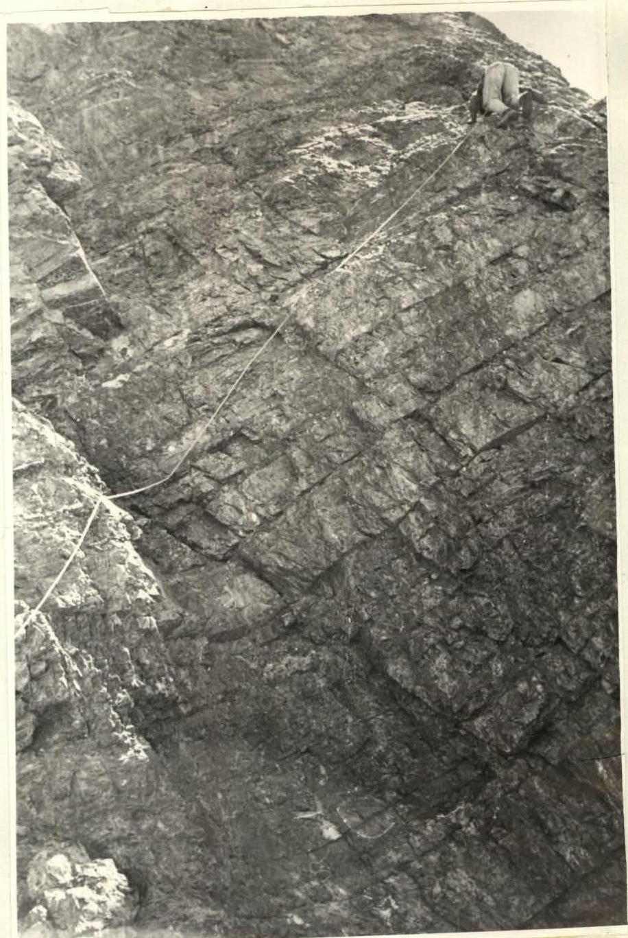
Section R9
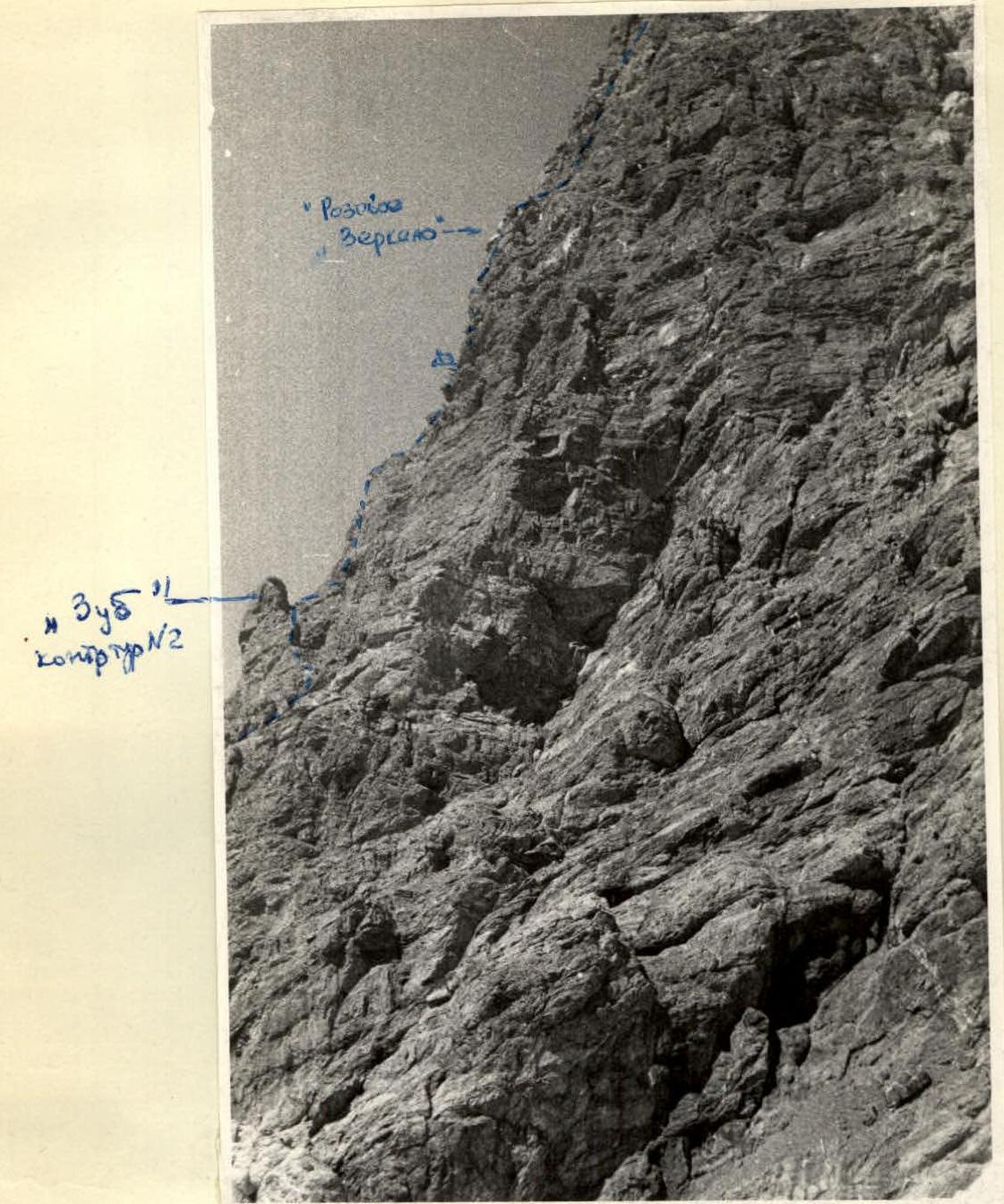
Diagram of the platform on July 26, 10:00. We depart on the route late, as the wall's exposure is western. The rocks are shaded, very cold. From the platform, we ascend onto a ledge that breaks off in places, going to the right upwards for 30 m. Climbing is of medium difficulty, initially 5-7 m - leaning backwards. Insurance - three hooks. We approach the outer corner and, traversing along a narrow ledge to the right, approach a chimney with a steepness of 45-50° and a length of 20 m. When passing the narrow ledge, two hooks are hammered, insurance in the chimney - through outcrops. The chimney ends with a large, tapering upwards gap between the wall on the right and the overhanging pink "mirror" on the left. In the upper part of the gap, a plug overhangs. The exit from the gap onto the pink "mirror" is very difficult. The rocks lean backwards. We pass this section without backpacks. Its length is 10-12 m, three hooks are hammered. We exit onto a small platform from which the exit to the upper part of the black wall is visible. From here, the upper part of the route - the pink wall - is also visible. We pull up the backpacks along the rope.
Section R10
From the platform, straight up along the smooth rocks, we ascend for 20 m and traverse to the right onto a rope, bypassing the upper part of the black wall. Further along the rusty rocks, to the left upwards, we return to the black wall. Movement with intermittent insurance through outcrops and hooks - 4 hooks. Rocks of medium difficulty.
Section R11
Straight up along the black rocks, we approach a 5-meter wall, with a steepness of 85-90°, monolithic, with few holds, difficult to organize hook insurance. Above the wall, there are many loose rocks, climbing is very difficult, and it goes slowly and with tension. The entire section up to the "white mirror" is 30 m. The overall steepness is 65-70°. Hook insurance - 3 petal hooks. The "mirror" is a slab of white marble, cut by small cracks, with a steepness of 50-55°, length 40 m. Four hooks are hammered. Along the "mirror", we exit onto a 30-meter ridge, with a steepness of 35-40°. It leads to the "ram's foreheads". The black wall has ended. Here is control cairn #4.
Section R12
Along the gentle "ram's foreheads", with simple climbing, we approach the sheer wall, which we bypass on the left along a ledge and, carefully crossing the couloir, we exit again onto the steeper "ram's foreheads" rising upwards in small terraces. The steepness of this section is 45-50°. When passing the couloirs, 2 hooks are hammered, and another 2 on the upper "ram's foreheads". The length of this section is 150 m. Above the "ram's foreheads", there is a large platform suitable for overnight stay, with snow. From here, the path along the "pink" wall is visible, which connects to the "ram's foreheads" with a wide snow bridge 30 m long.
Section R13
The path along the "pink wall" is chosen in the lower part along a gap, along which we pass one rope, then move to the right upwards - another rope into a couloir filled with ice. The transition from the gap to the couloir - dissected rocks with a large number of outcrops - an ice hook and two wedges are hammered.
The right part of the couloir:
- a smooth rock wall about 300 m high.
The left wall of the couloir:
- a rock wall with a smooth surface.
We pass the couloir, cutting steps in the ice with hook insurance (3 rock hooks and one ice hook) and use outcrops. The couloir ends with a small platform where one person can stand and organize insurance.
The whole day, the wind whistles in our ears, and as soon as we exit the couloir, it hits us even harder.
From the platform, the only possible path is along the internal corner of the white-pink wall, in the part that faces the northern exposure of Chimtarga's ridge. The walls of the corner are mostly smooth, and the upper part has to be passed by hanging over the lower wall. The steepness of the corner is 60-65°, insurance with four rock hooks. The entire section is 160 m long.
Section R14
The corner ends with a small platform - a depression that can accommodate no more than two people. From here, straight up for 20 m along rocks with a steepness of 70-75°, we exit onto the northern part of the ridge. The holds are very small, the rocks are crumbling, and we have to climb carefully. For insurance, we hammer two petal hooks. From here to the ridge, there are 200 m of smooth rocks with a steepness of 60-65° and partially crumbling. The next section is rockfall-prone. We have to move carefully. The holds are small, so we rely on friction. For insurance, we manage to hammer only two hooks. Finally, we exit onto the ridge. Time 20:30. We need to stop for the night. We find a platform for the tent to the right of the ridge and 20 meters below it. On the ridge, we leave control cairn #5. The platform is chosen better than the first. The height is about 5100 m, as Mirali and Energiya peaks are at the level of our overnight stay. At 21:00, we launch a flare. A response flare takes off immediately. The overnight stay is very poor. The whole night, a hurricane-force wind tears at the tent.
Section R15
In the morning, we depart on the route at 9:35. It's cold, with strong wind. We return to the ridge and along the "ram's foreheads" continue moving towards the pre-summit part of the ridge. The movement of the rope is simultaneous, in places intermittent. After an hour and a half of walking, we exit under the pre-summit ridge. Here, the backpacks were left.
Further, the path from the saddle to the summit is snow-ice, about 200 m. Bypassing the crevasses on the left upwards, we pass the open bergschrund and along the snow-ice ridge, we exit onto the summit. Insurance is through an ice axe. The snow is dense, holding steps well. At 14:00, we reach the summit, leaving our note. The Kaluzhsky group's team had already been to the summit, but their note is jubilee. The descent initially goes along the snow fields to the northern pre-summit, and then along a 40-meter rock wall onto the eastern snow slopes and along them, we traverse to the lowest saddle in the meridional ridge. Further - down along the snow slopes, to the labyrinth of ice drops (sticking to the stream) and scree into the Pravy Zindon valley. At 21:00, the group was back in the assault camp.
On July 26, we depart late - at 10:00. The rocks are cold, lit by the sun late. On this day, we passed 10 ropes. The chimney with the subsequent two "mirrors" were particularly difficult. The chimney's rocks are smooth, with few holds, and we managed to hammer in insufficient hooks. The first climber went mainly on friction. We pulled up the backpacks. Passing the "mirror" took about 3 hours. After the black wall, we went along the "ram's foreheads". We settled down for the night on the side of the ridge late in the evening, due to searching for a suitable platform. The overnight platform is good, but the whole night a very strong wind was blowing, threatening to tear off the tent. The second overnight stay is higher - 5000 m.
On the third day, July 27, we depart at 9:30. It's cold, with strong wind. We return to the ridge and along the "ram's foreheads" exit onto the pre-summit part of the ridge. Here, we leave the backpacks. Further, the path is snow-ice with overcoming a bergschrund. The slope steepness is 50-60°. The rope movement is simultaneous. At 14:00 - on the summit. We leave our note and begin the descent. Initially, the descent goes along the snow-ice slope to the northern pre-summit, then along crumbling rocks and down along the snow fields to the labyrinth of ice drops. Further, along the scree into the Pravy Zindon valley. At 21:00, the group was back in the assault camp.
The character of the route is mainly wall climbing, logical, diverse in relief, requiring the application of all techniques of rock climbing. The specificity of this route is limestone rocks, providing good grip with rubber. The small number of cracks led to the fact that on 29 ropes of continuous rock climbing, relatively few hooks were hammered (61 pieces). Duralumin wedges of various sizes were widely used. The height of the route is about 1380 m, the length is almost 2 km, of which the wall sections are 1000 m. The route, in our opinion, deserves a 5B category of difficulty.
Table of Main Characteristics of the Ascent Route to Chimtarga Peak via the Western Wall
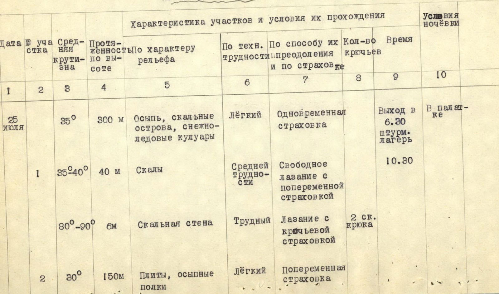
| Date | Section # | Average Steepness | Height Gain | Character of Relief | Technical Difficulty | Method of Overcoming and Insurance | Number of Hooks | Time | Overnight Conditions |
|---|---|---|---|---|---|---|---|---|---|
| July 25 | 35° | 300 m | Scree, rock outcrops, snow-ice couloirs | Easy | Simultaneous insurance | Departure at 6:30, assault camp | In a tent | ||
| July 25 | 1 | 35-40° | 40 m | Rocks | Medium difficulty | Free climbing with intermittent insurance | 10:30 | ||
| July 25 | 2 | 80-90° | 6 m | Rock wall | Difficult | Climbing with hook insurance | 2 rock hooks | ||
| July 25 | 3 | 60-65° | 20 m | Wall | Difficult | Climbing with hook insurance | 3 rock hooks | ||
| July 25 | 4 | 55-60° | 35 m | Wall | Difficult | Hook insurance | 3 rock hooks | ||
| July 25 | 5 | 75-80° | 20 m | Chimney | Very difficult | Hook insurance | 3 rock hooks | ||
| July 25 | 6 | 40-45° | 60 m | Ledges | Medium difficulty | Rappel | 2 rock hooks | ||
| July 25 | 6a | 80° | 30 m | Wall | Difficult | Hook insurance | 4 rock hooks | ||
| July 25 | 7 | 60-90° | 40 m | Wall, corner | Very difficult | Climbing with hook insurance | 3 rock hooks, 4 wedges | ||
| July 25 | 8 | 50-55° | 80 m | Rocks of medium difficulty | Medium difficulty | Hook insurance and through outcrops | 3 rock hooks | Overnight at 19:00 | |
| July 26 | 9 | 40-45° | 30 m | Rocks | Medium difficulty | Rappel with hook insurance | 3 rock hooks | Departure at 10:00 | |
| July 26 | 9a | 80° | 20 m | Chimney | Difficult | Climbing with hook insurance | 2 rock hooks | ||
| July 26 | 9b | 90° | 10 m | "Mirror" | Very difficult | Climbing with hook insurance, 10 m ladder | 3 rock hooks | ||
| July 26 | 10 | 40-45° | 60 m | Rocks | Medium difficulty | Free climbing with hook insurance and through outcrops | 4 rock hooks | ||
| July 26 | 11 | 65-70° | 30 m | Wall | Very difficult | Hook insurance | 3 rock hooks | ||
| July 26 | 11a | 65° | 40 m | "White mirror" | Difficult | Climbing with hook insurance | 4 rock hooks | ||
| July 26 | 12 | 45-50° | 160 m | "Ram's foreheads", couloir | Medium difficulty | Climbing with hook insurance | 4 rock hooks | ||
| July 26 | 13 | 60-65° | 80 m | Dissected rocks | Difficult | Insurance through outcrops and hook insurance | 2 wedges, 1 ice hook | ||
| July 26 | 13a | 60-65° | 160 m | Couloir, internal corner | Difficult | Hook insurance | 7 rock hooks, 1 ice hook | ||
| July 26 | 14 | 70-75° | 20 m | Rocks | Difficult | Climbing with hook insurance | 2 rock hooks | ||
| July 26 | 14a | 40-45° | 200 m | "Ram's foreheads" | Medium difficulty | Insurance through outcrops | 2 rock hooks | Overnight at 20:30 | |
| July 27 | 15 | 35-40° | 400 m | "Ram's foreheads" | Easy and medium difficulty | Simultaneous insurance | Departure at 9:30 | ||
| July 27 | 16 | 50-55° | 600 m | Snow-ice ridge | Medium difficulty | Simultaneous and intermittent insurance | 1 ice hook | On the summit at 14:00 |
Route of the 1st day of ascent

Exit to the main wall - section R2-R3

Exit to the chimney - section R5-R8
Exit to the couloir - section R12