9. Ascent Passport
- Ascent Class
- Rock climbing.
- Ascent Area
- Fann Mountains, northern ridge of the nodal peak Aurondag in the Zarafshan Range.
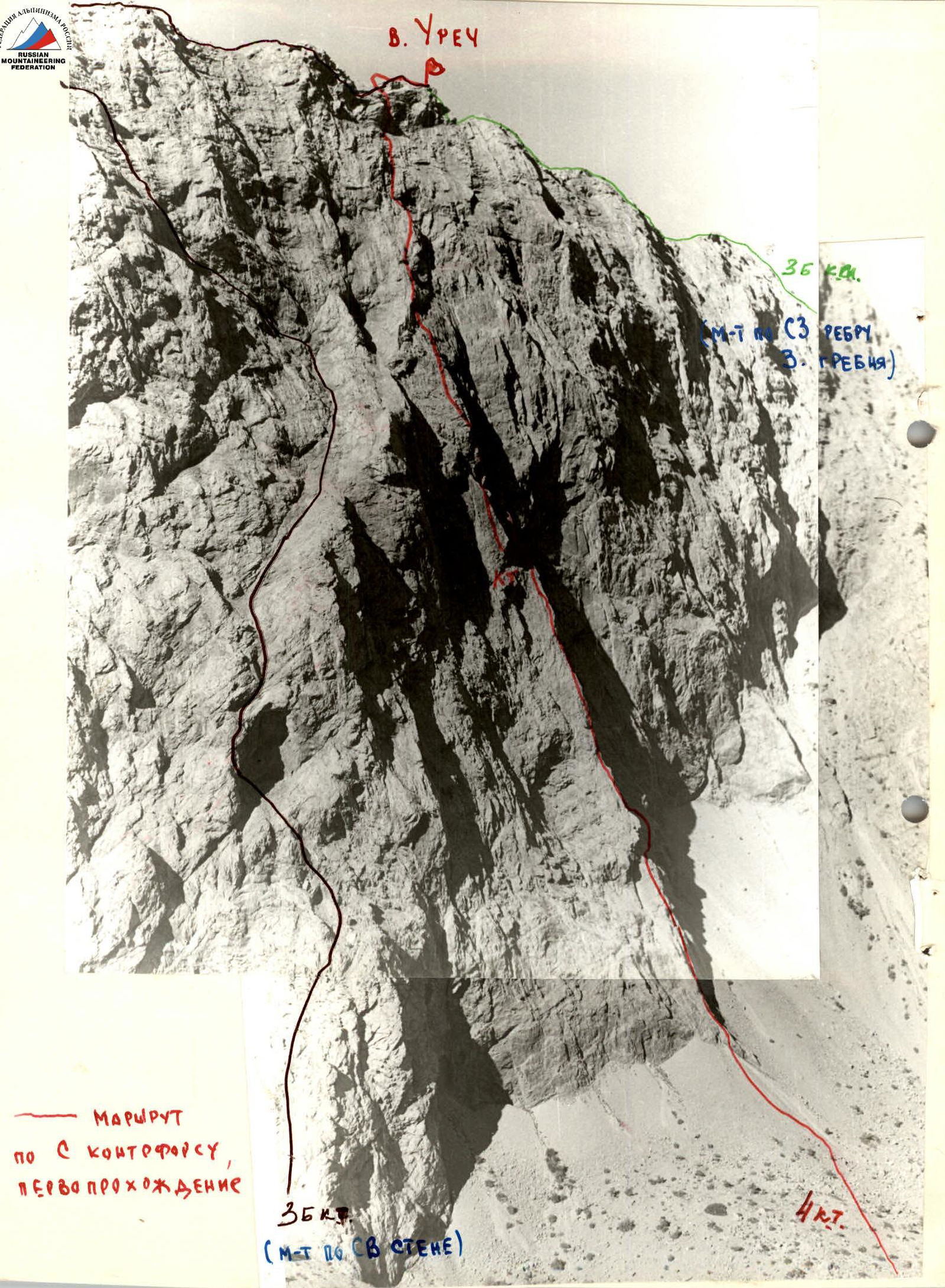
- Urech Peak, height 3400 m, route
- via the spur of the northeastern wall.
- Proposed difficulty category
- 4B.
- Height difference 690 m, average steepness — 65°–70°
- Pitons hammered in: for belaying — 76; for creating I.T.O. — 4.
- Number of climbing hours — 10.5.
- Number of nights stayed
- no overnight stays
- Group Composition:
Leader — Anatoly Tikhonovich Chervyakov, 1st sports category, Alexander Nikolayevich Barchuk, 1st sports category, Stanislav Fedorovich Klavanich, 1st sports category, Galina Mitrofanovna Kitnik, 1st sports category. 10. Team Coach: Oleg Ivanovich Shumilov, Master of Sports, senior instructor.
- Departure to the route and return to "Artuch" alpine camp on September 9, 1979.
I. Ascent Objectives
The increasing number of climbers at the "Artuch" alpine camp and the area's popularity, attracting numerous gatherings, have overloaded the area's routes. Many ascent routes have been frequently climbed. Therefore, traversing new routes in the area adjacent to the alpine camp is a top priority.
The ascent to Urech Peak via the spur of the Northeastern wall was undertaken by a group of instructors and climbers according to the plan of the educational department of the "Artuch" alpine camp.
2. Geographical Location of the Peak
"Urech" Peak is located in the northern spur of the nodal peak Aurondag in the Zarafshan Range, and more precisely, it closes this spur to the north. To the south, Urech Peak is only slightly elevated above the ridge (150 m), and the ascent is quite simple. From the peak, ridges stretch out to the west, northwest, north, and east.
There are three routes to Urech Peak:
-
- Eastern ridge, 2B difficulty category.
-
- Western ridge, 3B difficulty category.
-
- Northeastern wall (through the cave), 3B difficulty category.
A map of the area is shown in Fig. 1.
3. Ascent Preparation
The planned route for the first ascent is located to the right of the 3B category route (through the cave) along the clearly defined spur of the Northeastern wall, heading straight up to the peak. The route is complex and logical. This route was proposed by the head of the Fann Mountains Control and Safety Point (KSP), Master of Sports T.M. Mumdzhi. After reviewing, photographing, and sketching the route, the group received permission for the ascent.
The group consisted of:
- two instructors;
- two climbers with experience ascending peaks of 5th difficulty category.
Directly before the ascent, the group prepared:
- a tactical plan;
- selected the necessary gear;
- coordinated a schedule with other groups ascending nearby peaks.
4. Ascent Description
From "Artuch" camp, follow the trail leading to "Kulikolonskie Lakes". After the first ascent, head right towards a clearly visible scree slope under the spur of the Northeastern wall of Urech Peak. The journey from "Artuch" camp to the start of the route takes 2 hours (directional cairn).
Climb up the smoothed slabs of the spur:
- straight up through moderately difficult rock;
- reach the base of a wall;
- under an overhanging wall, traverse right, then up and left to reach the ridge of the spur;
- continue straight up through a clearly defined cleft, navigating difficult rock to an scree shelf under black overhanging rocks.
On the scree shelf, a "control cairn" is built.
Features of the "control cairn":
- built under an overhang;
- not in danger from rockfall;
- it is also impossible to bypass it, as it is directly at the point where the spur ridge meets the scree shelf.
The route continues:
- along the shelf to the left towards a wall resembling an "open book";
- climb up the left side of this wall;
- before reaching the "top of the book", traverse right and up under overhanging rocks (first key point);
- pass a 4-meter overhang using a ladder;
- continue up and left through difficult rock to reach the second section of the spur;
- navigate complex rock on the spur to a "yellow" triangular overhanging wall;
- bypass this wall on the left via a slab to reach the top of the wall;
- continue straight up through steep, smoothed slabs (resembling tiles) with overhangs and difficult rock to a shelf that runs under the overhanging rocks of the pre-summit ridge.
Along the shelf, traverse right and up through complex, broken rock to the pre-summit ridge (second key point). Follow the ridge to the summit.
5. Area Map

8. Table of Main Characteristics of Ascent Routes
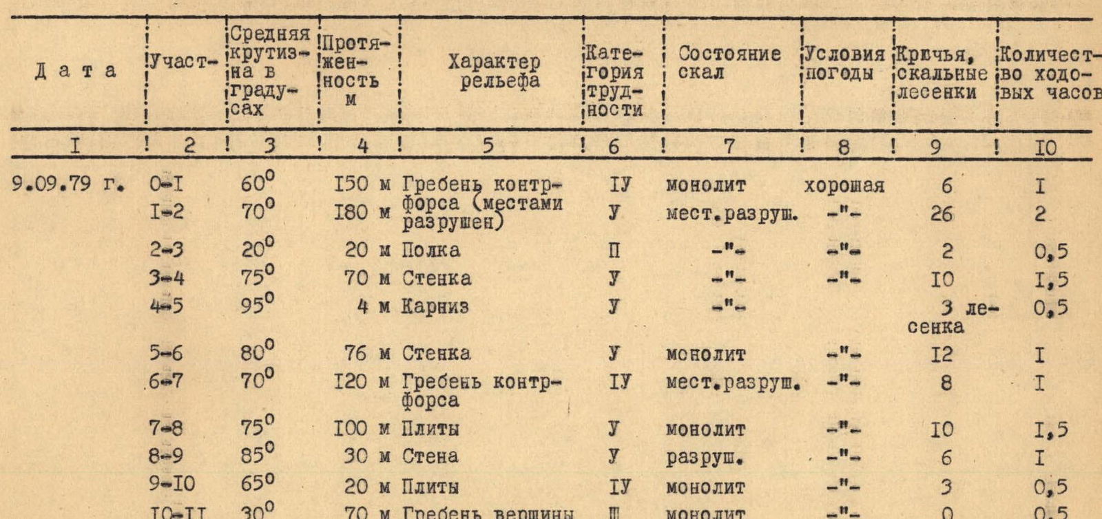

Route traversal