
PASSPORT
1. Rock climbing category 2. Pamir-Alay. Northern part of Fann Mountains. Surkhob valley. 3. Peak 4100 m (Surkhob) via the eastern wall. 4. Proposed 6B category of difficulty, first ascent. 5. Height difference 1030 m, route length 1250 m.
Length of sections:
- 5 category of difficulty — 1000 m
- 6 category of difficulty — 400 m
Average slope of the route 62°. Average slope of the wall section of the route 70°.
6. Pitons hammered:
| Rock | Bolt | Nuts | Ice |
|---|---|---|---|
| 159 | 10 | 100 | 0 |
7. Team's climbing hours — 30 h. Days — 3.
Descent on the 4th day — 5 h.
8. Night bivouacs 1 and 2 — lying, 3 — on the summit. 9. Leader: Prilepa Evgeny Vladimirovich Participants:
- Vorobyev Vladimir Vasilyevich CMS
- Doktorov Andrey Alekseyevich CMS
- Mazitov Pavel Borisovich CMS 10. Coaches:
- Kapitanov O.V. Master of Sports of the USSR, I category
- Shepilov V.A. Master of Sports of the USSR, I category 11. Approach to the route: July 16, 1991 summit: July 18, 1991 return: July 19, 1991 12. Organization: State Committee for Youth Affairs, Physical Culture, and Sports of the Tajik SSR.

Photo 1. General photograph of the summit. Taken on July 9, 1991 at 12:00 with a "Smena Simvol" camera and T-43 lens with a focal length of 40 mm. Distance to the object ≅1.5 km, height of the shooting point 3400 m.
Tactical Actions of the Team
The team developed a tactical plan for the ascent, calculated for four climbing days. Visual observation from the Eastern wall of Peak 4010 m showed that there are places on the route suitable for organizing overnight bivouacs. Therefore, the team planned to start the route without prior processing. The route is fairly even throughout its length. The summit was planned to be reached with two overnight bivouacs. Descent from the summit was planned for the fourth day.
During the ascent, all team members took turns leading: on section R0–R8 — Prilepa, R8–R13 — Mazitov, R13–R15 — Doktorov, R15–R18 — Vorobyev, R18–R25 — Prilepa, R25–R28 — Mazitov. The team traversed the ridge section independently in pairs. On sections R1–R28, bolt pitons and "Sky Hooks" were used for passing the rope protection. "Stations" for organizing protection and rope protection were set up on three to four elements.
Safety was ensured by:
- working on a double rope,
- choosing a safe direction of movement,
- organizing protection in safe places.
Overnight bivouacs were organized on ledges (lying), protected by large cornices. Communication with the base camp was maintained through observers and a rescue team, using "Kaktus" radios. Observation was conducted through a 12x binocular. There were no falls or injuries among the participants.
The team used the full range of modern tactical and technical means, tested at All-Union competitions.
| Rock | Nuts | Bolt | Ice | Section | Cat. diff. | Length (m) | Steepness (°) | Note |
|---|---|---|---|---|---|---|---|---|
| 4 | 3 | – | – | R0–R1 | 6 | 40 | 85 | |
| 6 | 5/2 | 1/1 | – | R1–R2 | 5 | 20 | 60 | |
| 4 | 2 | – | – | R2–R3 | 5 | 40 | 60 | |
| 3 | 4 | – | – | R3–R4 | 5 | 45 | 65 | |
| 5/2 | 4 | – | – | R4–R5 | 6 | 25 | 70 | |
| 2 | 2 | – | – | R5–R6 | 5 | 60 | 55 | |
| 6/3 | 5/1 | 1 | – | R6–R7 | 6 | 40 | 80 | |
| 10 | 7 | – | – | R7–R8 | 5 | 25 | 55 | |
| 1 | 4 | 1 | – | R8–R9 | 6 | 25 | 75 | |
| 5 | 2 | – | – | R9–R10 | 5 | 20 | 55 | |
| 5 | 3 | 4 | – | R10–R11 | 5 | 45 | 65 | |
| 2 | 4 | – | – | R11–R12 | 6 | 40 | 75 | |
| 6 | 3 | – | – | R12–R13 | 5 | 40 | 70 | |
| – | – | – | – | R13–R14 | 6 | 45 | 85 | July 17, 1991 7:00 — July 16, 1991 18:00, 11 h |
| – | – | – | – | R14–R15 | 6 | 30 | 75 | |
| – | – | – | – | R15–R16 | 5 | 45 | 70 | July 17, 1991 14:00 — processing up to section R18 |
| – | – | – | – | R16–R17 | 5 | 20 | 55 | 2nd Control Point July 18, 1991 7:00 |
| – | – | – | – | R17–R18 | 5 | 30 | 70 | processing on July 17, 1991 until 14:00, descent to bivouac (7 h) |
| – | – | – | – | R18–R19 | 6 | 45 | 85 | |
| – | – | – | – | R19–R20 | 5 | 20 | 60 | |
| – | – | – | – | R20–R21 | 6 | 45 | 80 | |
| – | – | – | – | R21–R22 | 6 | 20 | 80 | |
| – | – | – | – | R22–R23 | 5 | 25 | 60 | |
| – | – | – | – | R23–R24 | 5 | 30 | 80 | |
| – | – | – | – | R24–R25 | 6 | 40 | 85 | |
| – | – | – | – | R25–R26 | 5 | 45 | 70 | |
| – | – | – | – | R26–R27 | 5 | 45 | 65 | |
| – | – | – | – | R27–R28 | 5 | 10 | 80 | |
| – | – | – | – | R28–R29 | 4 | 250 | 45 |
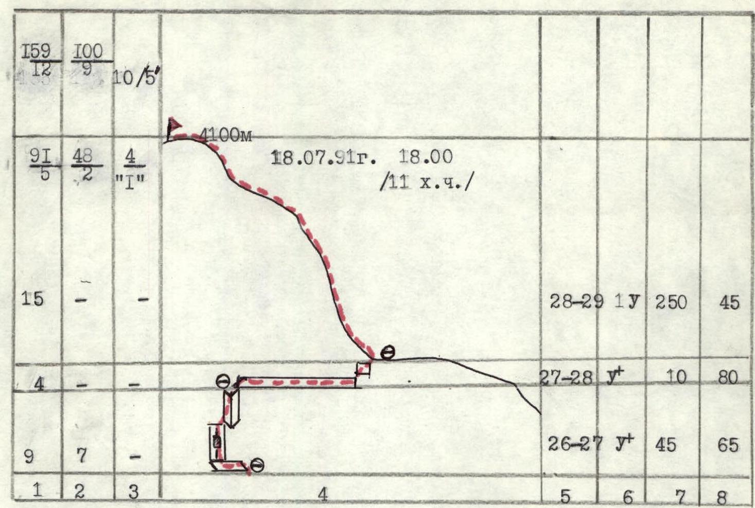
Note: "A small hole dug with a piton for a 'Sky Hook'". The team spent 30 climbing hours. Height difference 1030 m, length of sections 5–6 category of difficulty 1050 m.
Description of the Route by Sections
Approach to the Route
- From the base camp to the grove by the river takes 45 min.
- Ascend along the sharp moraine between the glacier and the wall to the "gap".
- From the "gap", ascend upwards to the cave from which a stream flows.
- 50 m below the cave, to the right, the route starts up the internal angle leading to the wall.
Section R0–R2
Ascend the wall to a steep internal angle. Climbing is complex. Protection is organized through pitons. The internal angle leads under a rusty overhang. Through a small cornice along the wall for 20 m, reach the level of the grotto. The wall leads to a wide internal angle.
Section R2–R6
Internal angle 110 m. There are convenient places for organizing protection. Steepness increases in the upper part. The angle leads to a gentle ledge. Along the ledge to the left and then along the right part of the internal angle to a steep wall. There is a good landmark — a large rock spire, bypassed on the right.
Section R6–R8
Steep smooth wall. Climbing is complex. For protection, use:
- thin rock pitons
- bolt pitons
Along the right part of the cornice, reach a ledge with archa, on the ledge — the first control point.
Section R8–R10
Ledges — a complex transition to the left along a weakly expressed angle and wall under a cornice to a quartz cave. In the cave, there are quartz druses. From under the cornice, swing left along the wall to a steep internal angle. Transitions to the left are particularly challenging on this section. Along the internal angle, reach a ledge.
Section R10–R13
Along the ledge to the right, enter an internal angle, which after 40 m leads to a shallow, grassy cave. To the left of the cave — up a steep wall. Climbing is complex. "Sky Hooks" — a removable bolt piton for protection are used. Further — along a series of internal angles upwards to the beginning of a large cirque, overhung by cornices in a semicircle around the perimeter at a height of about 400 m and vertically by 150 m. Slightly left of center, a possible path upwards is visible, towards a large cave. Along a series of overhanging walls and internal angles, approach the base of the cornice belt. To the right — upwards — a convenient grotto for a bivouac, protected by a cornice.
Section R13–R15
Very complex climbing:
- from the bivouac site to the left along smooth slabs;
- to the right, pass above the hanging cornices;
- up a steep internal angle using artificial aids;
- transition along a smooth wall to the left;
- further along the internal angle upwards.
This section is the most challenging and time-consuming. Bolt pitons and "Sky Hooks" are necessary. Few cracks for reliable protection. Along a series of walls and internal angles, reach a ledge.
To the left — a bivouac in a cave. The team was forced to stop for the night due to heavy snowfall.
Section R16–R20
From the cave to the right, along an internal angle, reach a series of steep walls. Climbing is complex. Rocks are monolithic, cracks are shallow. Along an overhanging internal angle for 25 m using artificial aids. Rocks are weak. The exit from the internal angle to the saddle is heavily destroyed. Saddle and overhang — to a ledge.
Section R20–R24
Along the ledge to the left and up the right part of the internal angle. In places, the angle is overhanging — climbing is complex. At the top, move along the left part of the angle. Reach a smooth wall by swinging left, transition from under the overhang to a wall with good holds.
Along the wall and a short internal angle, reach under a large cornice. Under the cornice on a ledge, the third control point is set. To the left — upwards, exit to the upper part of the cornice and swing left onto the wall.
Piton protection is unreliable. Use bolt pitons and "Sky Hooks". Exit above the cornice. Poor place for organizing protection.
Section R24–R27
Along the internal angle — through a series of overhangs. Complex. Use bolt pitons. Reach a ledge, there is a convenient place for organizing protection. Along the ledge to the left and up the wall to a grotto under a cornice. From the grotto, exit left along an inclined ledge to a crack and up it, using artificial aids. Further, again to the left along a ledge and a series of walls and internal angles, reach under an overhang.
Section R27–R29
Along a long ledge to the right and a short complex wall, reach the ridge. Along the ridge for 250 m, easy climbing to the summit.
Descent down steep walls initially to the east to a saddle. Descent by rappelling for 100 m. Further — three ropes. Rappelling to the moraine and then — to the base camp.
Descent takes 5 h.