Ascent Passport
- Ascent class: technical
- Ascent area: Pamir-Alai, Fann Mountains, Levyy Zindon gorge
- Ascent object: SOAN via N wall of NW ridge, height 4750 m
- Difficulty category: 5B
- Route characteristics: height difference 1400 m, length 2400 m, length of sections VIk/tr: 430 m, average steepness of the wall 65–70°, ridge 30°
- Pitons driven: for ITO — , for belay:
- bolt pitons – 8
- rock pitons – 72
- chocks – 21
- Number of climbing hours: 19
- Number of nights: one, lying down
- Team composition:
- Martynov Aleksandr Ilyich, CMS, leader
- Bondarenko Sergey Aleksandrovich, KIS
- Date of departure and return: June 24–25, 1981
2nd 21/VI-81. V. Goloshchapov, L. Volkov (X-B)
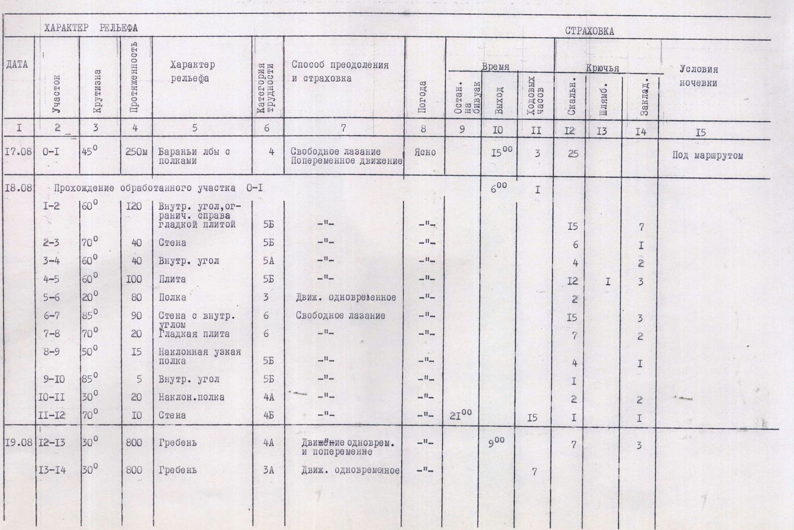
Table of Main Characteristics of the Ascent Route to Peak SOAN
| DATE | Section | Steepness | Length | Terrain characteristics | Difficulty category | Method of ascent and belay | Weather | Time | Climbing hours | Pitons | Bolt | Chocks | Camping conditions |
|---|---|---|---|---|---|---|---|---|---|---|---|---|---|
| 17.08 | R0–R1 | 45° | 250 m | "Ram's foreheads" with ledges | 4 | Free climbing, alternating movement | Clear | 15:00 | 3 | 25 | Below the route | ||
| 18.08 | Passage of the processed section R0–R1 | 6:00 | 1 | ||||||||||
| R1–R2 | 60° | 120 m | Inner corner, limited on the right by a smooth slab | 5B | –– | –– | 15 | 7 | |||||
| R2–R3 | 70° | 40 m | Wall | 5B | –– | –– | 6 | 1 | |||||
| R3–R4 | 60° | 40 m | Inner corner | 5A | –– | –– | 4 | 2 | |||||
| R4–R5 | 60° | 100 m | Slab | 5B | –– | –– | 12 | 1 | 3 | ||||
| R5–R6 | 20° | 80 m | Ledge | 3 | Simultaneous movement | –– | 2 | ||||||
| R6–R7 | 85° | 90 m | Wall with an inner corner | 6 | Free climbing | –– | 15 | 3 | |||||
| R7–R8 | 70° | 20 m | Smooth slab | 6 | –– | –– | 7 | 2 | |||||
| R8–R9 | 50° | 15 m | Narrow inclined ledge | 5B | –– | –– | 4 | 1 | |||||
| R9–R10 | 85° | 5 m | Inner corner | 5B | –– | –– | 1 | ||||||
| R10–R11 | 30° | 20 m | Inclined ledge | 4A | –– | –– | 2 | ||||||
| R11–R12 | 70° | 10 m | Wall | 4Б | –– | –– | 21:00 | 15 | 1 | 1 | |||
| 19.08 | R12–R13 | 30° | 800 m | Ridge | 4A | Simultaneous and alternating movement | –– | 9:00 | 7 | 3 | |||
| R13–R14 | 30° | 800 m | Ridge | 3А | Simultaneous movement | –– | 7 |
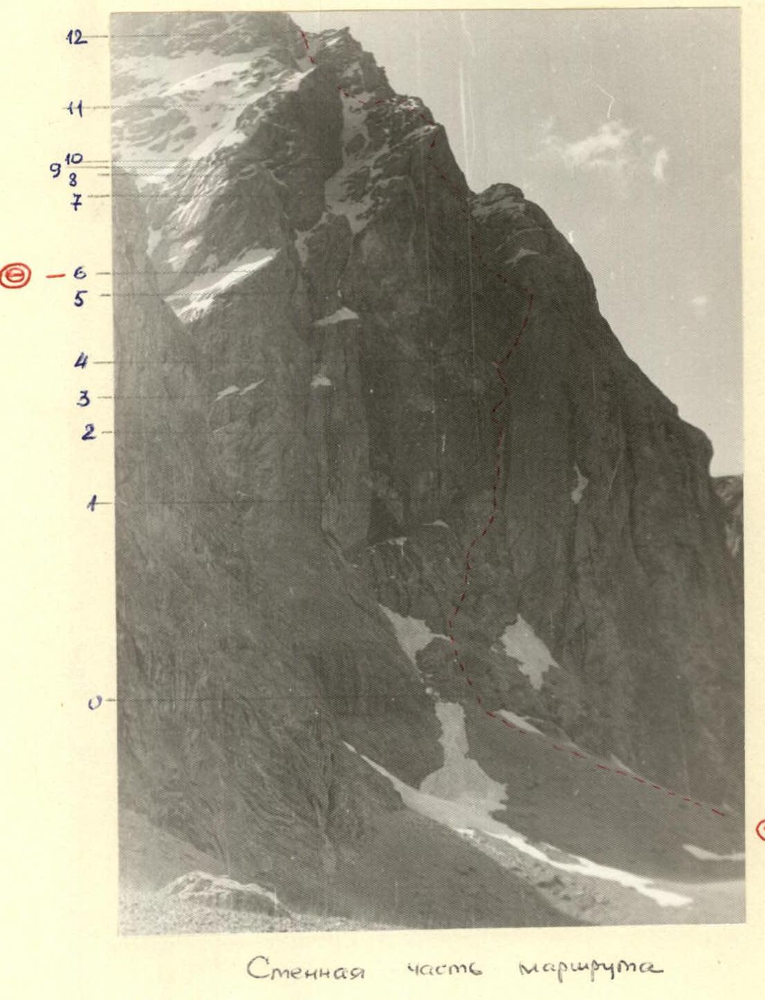
General view of the route (from Lake 5. Allo)
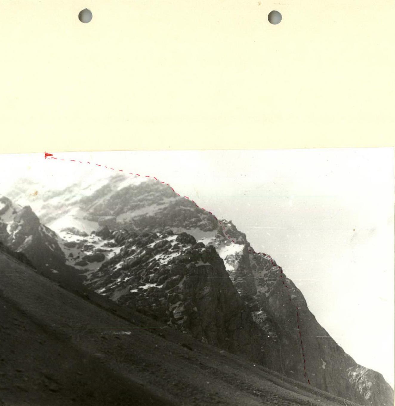
Wall part of the route – group's route, camping site
Brief Explanation of the Table
The route is very logical, and finding its start is not difficult (see photo). From the campsite at Lake Zindon to the start of the route is 30 minutes via scree. Section R0–R1: Quite steep "ram's foreheads". There are almost no places to drive pitons. Movement requires great care. Section R1–R2: Steep slab with no holds on the right, and overhanging rocks on the left. At the start of the section, there is a control cairn in a "bank". Climbing is very difficult. Section R2–R3: The overhanging section of the left wall of the inner corner is bypassed on the left via a steep wall, the initial part of which has a steepness of up to 80°. Section R3–R4: The inner corner, consisting of destroyed rocks, leads to a ledge located to the left of the slab. Section R4–R5: From the ledge, movement is along the right slab of the inner corner, 7–10 m from the left wall. The first climber moves without a backpack. 50 m from the ledge, two bolt pitons were driven by previous groups and can be used for belay. Section R5–R6: A gently sloping scree ledge leads to a site where a lying-down overnight stay is possible, and a tent can be set up. The site is safe and protected by rock overhangs. To the right of the ledge is one of the route's landmarks – a huge steep rock couloir. Section R6–R7: Move another 5–7 m further and go to the left wall with an inner corner. Climb straight up along it towards the right end of the steep slab. Here, loops of chocks left by the first ascenders are visible. Section R7–R8: Smooth steep slab with no holds. Climbed on friction with careful belay. Direction of movement is to the left, traversing. Section R8–R9: Difficult narrow ledge leading to a 5-meter inner corner (Section R9–R10). After passing the inner corner, there is a control cairn. Further movement continues along the rock ridge (R10–R12) with an exit to a snow couloir on the left (R12–R13). After the couloir, movement is along a long ridge with rock and snow sections (R12–R13), leading to the summit. Descent: Via a ridge towards Peak Zindon and then to the right, into the Levyy Zindon gorge. From the summit to Lake Zindon is about 4 hours.
List of Equipment Taken on the Route
- Main ropes 2 × 50 m
- Zdarsky tent
- "Shmel" primus stove, 0.5 l gasoline
- "Vitalka" radio station
- Hammer – 1
- Ice axe – 1
- Ice axe – 1
- Rock pitons – 20
- Chocks – 5
- Ladder – 2
- Climbing jammers – 2
- Saratovkin shock absorber – 1
- First aid kit – 1
- Galoshes – 2 pairs
- Personal equipment, 2 sets
- Food