ASCENT DOCUMENT
I. Climbing category — technical. 2. Climbing area, ridge — Fan Mountains, Zarafshan ridge. 3. Peak, its height, ascent route — V. SARYSHKH, 4650 m, via the northern wall of the eastern ridge, first ascent. 4. Proposed difficulty category — 4B. 5. Route characteristics:
total elevation gain — 650 m, wall section elevation gain — 375 m, length of sections with 5–6 cat. diff. — 280 m, average slope of the entire route — 40°, average slope of the wall section — 60°.
- Pitons hammered:
for belaying — 48, for creating anchor points — 1.
- Number of nights and their characteristics — 1, safe, convenient, on a rocky ridge.
- Number of climbing hours — 14.
- Surname, name, patronymic of the leader, participants, and their qualification: Babeshko Valentin Pavlovich — 1st sports category, leader, Fevziev Rishad Fevzievich — Candidate Master of Sports, Smirnov Gennadiy Konstantinovich — 1st sports category, Dronov Yuriy Vladimirovich — 1st sports category.
- Team coach — Mumdzhi T.M.
- Date of departure and return:
departure — August 8, 1978, return — August 9, 1978.
SARYSHKH 4650 m
ROUTE UP THE N WALL TO THE RIDGE, TAKEN BY THE TEAM
5A CATEGORY ROUTE UP THE LEFT PART OF THE NW (NE) WALL (PAVLICHENKO TEAM)
4A CATEGORY ROUTE ALONG THE EASTERN RIDGE (GALYA TEAM, UTD MNOVOI)
5B CATEGORY ROUTE UP THE CENTER OF THE LEFT PART OF THE NW (NE) WALL (BERSHOV TEAM)
5B CATEGORY ROUTE UP THE RIGHT PART OF THE N WALL (ZASYPKIN TEAM)
5B CATEGORY ROUTE (UNCLASSIFIED) UP THE RIGHT EDGE (RIGHT PART) OF THE NE WALL (OVCHARENKO TEAM)
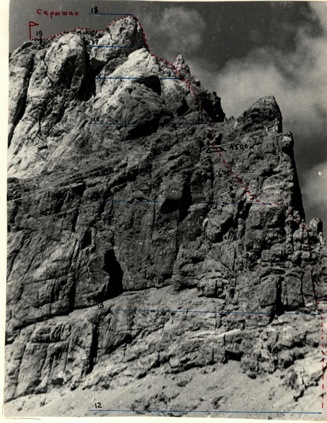
ROUTE UP THE NORTHERN WALL OF THE EASTERN RIDGE
PHOTO TAKEN FROM THE NORTHWEST
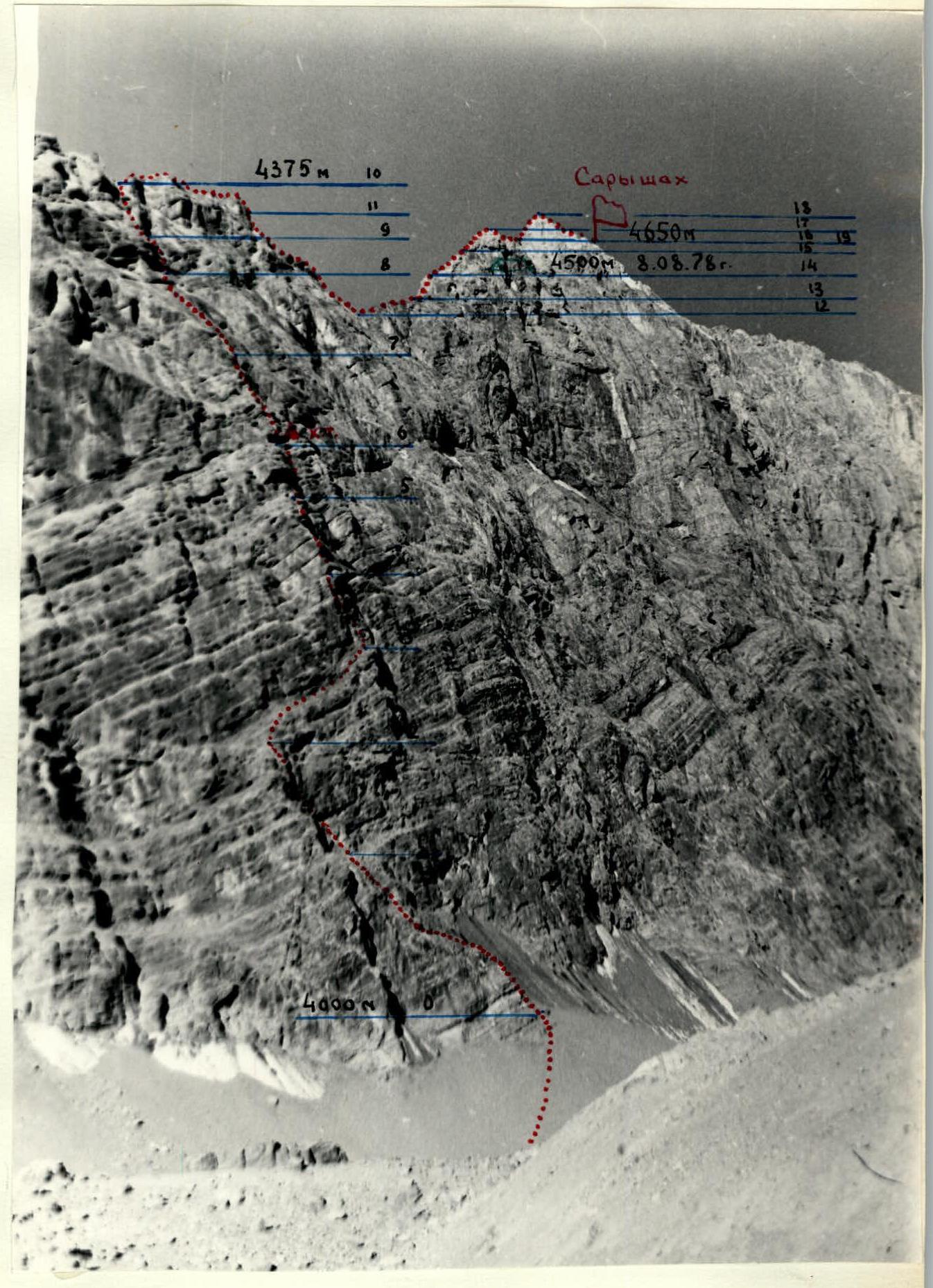
V. SARYSHKH AND UPPER PART OF THE EASTERN RIDGE
BRIEF EXPLANATION
To the table of main route characteristics
August 8, 1978. From the bivouac on the moraine to the start of the route via the glacier — 20 min.
Section R0–R1. Up the rocky "claw" from right to left, 80 m under the wall. Rocks are broken, blocky, moderately difficult. Belaying via outcrops.
Section R1–R2. Move vertically up 40 m to the start of a sloping ledge, clearly visible from below. Rocks are steep, climbing is difficult, piton belay.
Section R2–R3. Along the ledge from left to right, 60 m, climbing is difficult. The ledge continues further through a large steep couloir (Do not go right!!!). Piton belay.
Section R3–R4. Further along the rocky edge, 30 m vertically up through difficult rocks to the base of a small internal corner. Rocks are monolithic, good holds.
Section R4–R5. Internal corner turns into a wall, 35 m, difficult, steep. The wall ends with a small ledge.
Section R5–R6. Traverse the ledge from the right via a crack, 4 m, and then along a vaguely defined outer corner to a rocky niche. Here is a control cairn.
Section R6–R7. After the cairn, move along the edge, 50 m, to the base of a large inclined slab. Movement is hindered by a small number of holds, piton belay.
Section R7–R8. Across the slab to the right, 60 m, to a steep internal corner. The slab is monolithic, steep, holds are limited. In June and July, there is ice on the slab!
Section R8–R9. Up the internal corner, 20 m vertically. Climbing is difficult, exit to the wall.
Section R9–R10. Further up the wall, 40 m vertically. The wall leads to the eastern ridge of the peak.
Section R10–R11. Along the ridge, 60 m, to the descent into a pass. The ridge is broken, belaying via outcrops.
Section R11–R12. Descent into the pass, 30 m, via moderately difficult rocks.
Section R12–R13. After the pass, ascend 50 m to the base of a red wall with two cracks, simultaneous movement.
Section R13–R14. The wall, 40 m, is traversed via the right crack, very steep at the start. Rocks are monolithic, piton belay. A bivouac is set up on a wide rocky terrace.
August 9, 1978.
Section R14–R15. From the overnight spot, move along the ridge, 60 m, to a clearly visible internal corner, rocks are moderately difficult, belaying via outcrops.
Section R15–R16. Up the corner-chimney. Steep, but passes well on opposition. Piton belay.
Section R16–R17. Along a gentle rocky ridge, first simultaneously, then alternately along a sharp ridge towards the steep pre-summit wall. This is one of the most difficult sections of the 4A category route along the Eastern Ridge.
Section R17–R18. From left to right via a crack, 4–5 m, then left up a steep smooth wall with careful piton belay to the pre-summit ridge.
Section R18–R19. Further along a gentle rocky ridge — exit to the Saryshkh peak.
Descent along the eastern ridge towards the Mezhozerny pass. 50–60 m before the pass — descend left down the northern edge (spur) of the eastern ridge into the Auroundag glacier cirque.
Descent from Saryshkh peak to Auroundag glacier takes 5–6 hours. Further down the Zierat gorge to the "Artuch" alpine camp.