ASCENT DOCUMENT
- Ascent category — technical ascent category
- Ascent region — Fann Mountains, spur of the Zeravshan Range
- Peak
- Borzov za Mir
- a) elevation — 4100 m
- b) ascent route — via the South face
- Expected category of difficulty — 3B
- Route characteristics:
- a) elevation gain — 300 m
- b) length of sections: V–VI category of difficulty — 30 m; V category of difficulty
- c) average steepness of the route — 55°
- Total number of pitons — 46?
- of which:
- a) for belaying — 17
- b) for creating artificial holds — 6
- c) ice screws into rock — 2
- Total climbing hours — 8 hours
- Number and nature of bivouacs — no bivouacs
- Surname, first name, patronymic of the leader and participants, and their qualification
- Rybalko Leonid Mikhailovich — leader
- Belov Andrei Mikhailovich — 2nd sports category
- Vladimirova Tatiana Alex. — 2nd sports category
- Finkelstein Boris Lvov. — 2nd sports category
- Finkelstein Alexander — 1st sports category
- Dobrynin Nikolai Georg. — 1st sports category
- Team coach — Senior Instructor MS USSR SHUMILOV O.I.
- Date of departure and return — Ascent completed on June 27, 1979
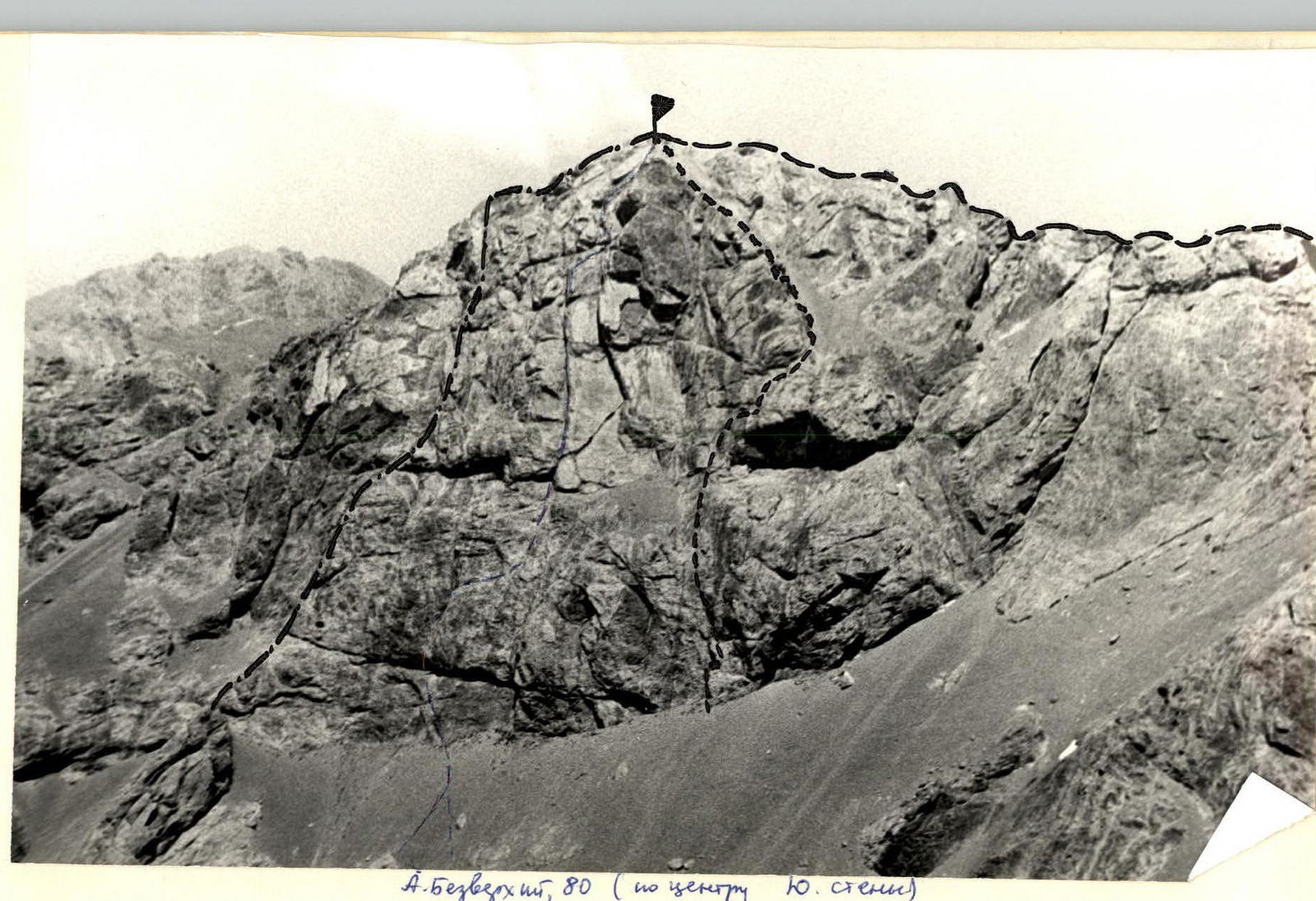
V. Bezvhozhiy, 80 (center of the S face) "Route 3A category via the western ridge" "Route 2A category from the South via the couloir of the Eastern ridge" "Route 3B"
TABLE OF MAIN CHARACTERISTICS OF THE ASCENT ROUTE
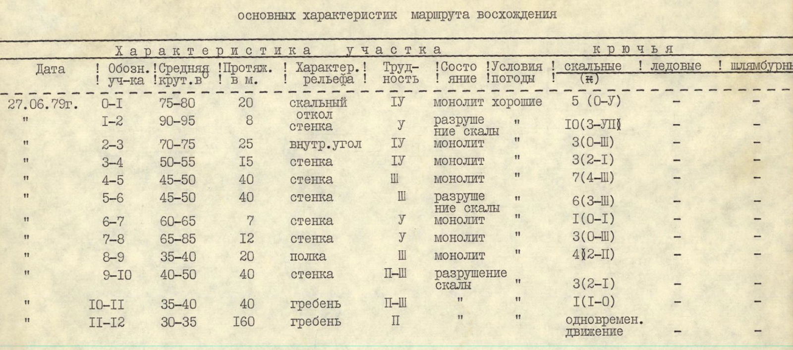 (note) In parentheses:
- Arabic numerals indicate the number of pitons used for belaying;
- Roman numerals indicate the number of intermediate pitons used to traverse a section.
| Date | Section designation | Average steepness in ° | Length in m | Terrain characteristics | Difficulty of section | Condition | Weather conditions | Rock pitons | Ice screws | Bolts |
|---|---|---|---|---|---|---|---|---|---|---|
| June 27, 1979 | R0–R1 | 75–80 | 20 | rock spalling | 4 | monolithic | good | 5 (0–5) | — | — |
| R1–R2 | 90–95 | 8 | wall | 5 | rock failure | " | 10 (3–7) | — | — | |
| R2–R3 | 70–75 | 25 | internal angle | 4 | monolithic | " | 3 (0–3) | — | — | |
| R3–R4 | 50–55 | 15 | wall | 4 | monolithic | " | 3 (2–1) | — | — | |
| R4–R5 | 45–50 | 40 | wall | 3 | monolithic | " | 7 (4–3) | — | — | |
| R5–R6 | 45–50 | 40 | wall | 3 | rock failure | " | 6 (3–3) | — | — | |
| R6–R7 | 60–65 | 7 | wall | 5 | monolithic | " | 1 (0–1) | — | — | |
| R7–R8 | 65–85 | 12 | wall | 5 | monolithic | " | 3 (0–3) | — | — | |
| R8–R9 | 35–40 | 20 | ledge | 3 | monolithic | " | 4 (2–1) | — | — | |
| R9–R10 | 40–50 | 40 | wall | 2–3 | rock failure | " | 3 (2–1) | — | — | |
| R10–R11 | 35–40 | 40 | ridge | 2–3 | " | " | 1 (1–0) | — | — | |
| R11–R12 | 30–35 | 160 | ridge | 2 | " | " | simultaneous movement | — | — |
ROUTE DESCRIPTION
From the base camp near Lake Bibi-Dzhanat, follow the trail, skirting the Western ridge descending from the peak Borzov za Mir, to the right, to a large boulder, from which the entire South face of the peak is visible.
From the boulder, ascend the scree slope to a clearly defined rock spall in the middle part of the face. A cairn is built at the start of the route. The ascent from the base camp near Lake Bibi-Dzhanat takes 1.5–2 hours.
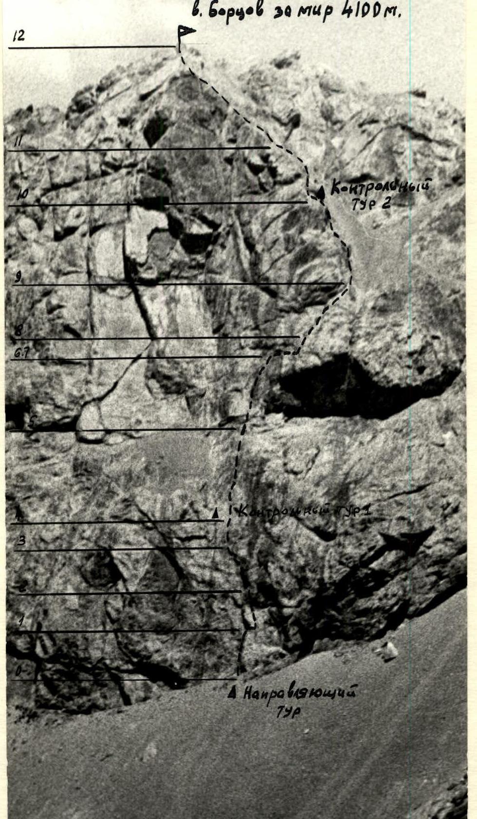
Ascend the rock spall via smooth rocks for 15 m to a small inclined ledge on the right side of the spall. From the ledge, move right to the wall and ascend destroyed rocks, 8–10 m up (ladders, key location) — exit into a wide crack, which is a continuation of the spall. Ascend the crack, transitioning into an internal angle, 40 m to a small ledge. On the ledge is the 1st control cairn.
From the ledge, ascend 40 m up to the exit onto the left part of a wide ledge under a large rusty-colored cornice in the middle of the face. The group can gather on the ledge. "The large rusty-colored cornice is bypassed on the left via moderately difficult destroyed rocks."
From the ledge, ascend 35–40 m up and slightly right to overhanging rocks. From the overhanging rocks (key location), traverse horizontally 7–8 m to the right along the wall without cracks for pitons and with few handholds. Then ascend directly up via difficult rocks for 12–15 m to a narrow inclined ledge, and along the ledge, moving right and up, 20 m.
From the end of the ledge, move left and up via moderately difficult rocks to exit onto a small ledge under an overhang. On the ledge is the 2nd control cairn.
From the control cairn, bypass the overhanging rocks on the left, exit onto the ridge, and ascend the ridge to the summit.
The ascent from the cairn under the route takes 8–10 hours. Descend from the summit via the Western ridge along easy rocks and a couloir, which exits onto the left scree slopes of the peak, to the trail near the large boulder. Descend along the trail via the ascent route. The descent from the summit to the base camp near Lake Bibi-Dzhanat takes 1 hour.
 www.alpfederation.ru↗