- Climbing class - technically challenging.
- Climbing area - Fan Mountains.
- Route - peak S. Bodkhona (5300) via N. wall, 5B category of difficulty (Kudinov I.B.'s route, 1968, 2nd ascent).
- Climbing characteristics:
route length - 3270 m, height difference - 2100 m, average steepness - 75°, length of difficult sections - 520 m, 6th category of difficulty.
- Pitons hammered:
- rock (including stoppers) - 292
- ice - 4
-
Number of climbing hours - 40
-
Number of nights - 4 (all comfortable)
-
Number of climbing days - 5
-
Team of LGS DSO "Spartak"
-
Team coach - Kolchin A.A., International Master of Sports.
-
Team members:
Razumov Yuri Mikhailovich - team leader, Candidate for Master of Sports.
Candidate for Master of Sports:
- Kolchin Alexander Alexandrovich - International Master of Sports.
- Isachenko Gennadiy Ivanovich - Candidate for Master of Sports.
- Silin Boris Mikhailovich - Candidate for Master of Sports.
- Date of ascent - July 15, 1979 – July 19, 1979
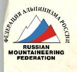
Route to peak S. Bodkhona via N. wall.
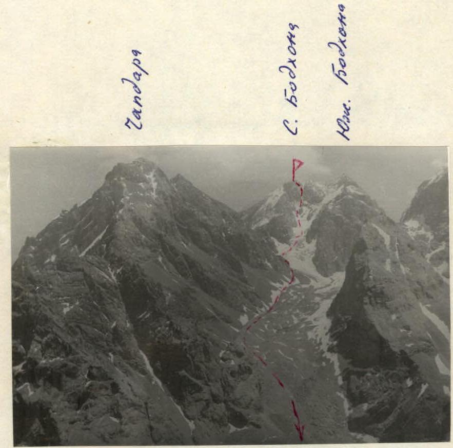
General view of Bodkhona massif from the west. All peaks of the massif and the descent path from the N. peak are visible.
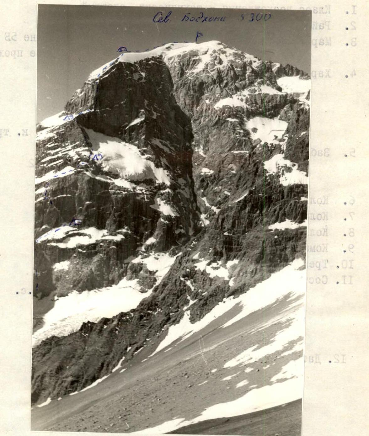
Description of the route to peak S. Bodkhona via N. wall (Kudinov's route, 1970)
The North wall of peak S. Bodkhona is cut by a giant couloir into two parts. Left of the couloir, in the center of the wall, there is a hanging glacier. Left of the glacier, at its level, there is a ridge that drops down to the glacier with a wall divided by a large snow shelf into two ascents.
The route goes:
- along this wall,
- then along the ridge,
- straight up the second wall, which the ridge abuts.
The first ascent of the lower wall is done in the left part, where the rocks are somewhat less steep than in the center.
Above the right part of the wall hangs the aforementioned glacier, and from the eastern ridge of the peak, left of the route, another glacier hangs. The falling ice from it limits the route on the left.
The base of the route is a bergschrund:
- according to our altimeter, it is at an altitude of 3200 m
- according to Kudinov's estimates - 3300 m.
After the first ascent (R0–R1, 400 m, 5th cat. diff.), the route goes along a steep snow shelf to the right and up to the highest point of the shelf, after which the shelf begins to descend. There is a good bivouac site there (3700 m). On the shelf (R1–R2, 360 m, 4-5 cat. diff.), insurance is done through an ice axe, sometimes through rock pitons and sometimes from a running belay. From the bergschrund to the bivouac site - 6 hours.
The second ascent of the wall is overcome by a large ledge to the left and up from the bivouac site (R2–R3, 250 m, 6th cat. diff.). This section is a series of very difficult walls, but with good ledges between them. In several places, the route passes under waterfalls from the right wall. It is recommended to pass this section in the morning, while the waterfalls are not yet strong.
The ledge leads to a shelf. Along the shelf to the left 25 m. Then to the right and up to the next large snow shelf (R3–R4, 150 m, 5-6 cat. diff.).
Along the snow shelves with rock walls to the right and up (R4–R5, 170 m, 4-5 cat. diff.). The main landmark on this section is the beginning of the ridge. On the ridge - the second bivouac site (altitude 4100 m). In total, 10 hours were spent on the R2–R5 section for the day.
Along the ridge, the first 2-3 ropes are relatively easy. Then it gets more difficult, up to 5th cat. diff. (R5–R6, 440 m, 4-5 cat. diff.).
Before the upper bastion, there is a good platform. Here is a bivouac site and a control tour in a sack on the wall near the platform. For the day, the section was passed. On the same day, they managed to process 4 ropes of the upper bastion.
From the bivouac site to the bastion:
- 100 m of snow with rock outcrops
(R6–R7, 3rd cat. diff.).
On the bastion, there is a seemingly sheer counterfort, which is a continuation of the ridge. It divides the wall of the bastion into NE and NW walls. The first ascenders climbed slightly left of the ridge. We chose a route slightly to the right. The detour to the right and up is the base of the counterfort, then to the left and up along the stream (between the stream and the ridge, with an exit to the ridge). The last rope of this section is straight along the ridge.
Sections to be passed:
- Section R7–R8: 320 m, 6th cat. diff.
- Section R8–R9: 120 m, 4th cat. diff., 3 ice pitons
- Section R9–R10: 240 m, 4-5 cat. diff.
Then along the snow-ice slope to the wall, leading to the edge of the rock-snow-ice slope. The path goes along the edge until it reaches the ice ridge leading to the summit.
Two ropes along the ridge and on its right side - a stony platform for a bivouac site. Altitude - 5000 m.
For the day (12 hours), sections R6–R10 were passed.
From the bivouac site to the summit along the ice ridge (R10–R11, 700 m, 3rd cat. diff., 3 hours).
Descent from the summit 40 m along the W ridge towards Chapdara and to the left into the couloir. Having descended 40 m, traverse to the left and then down into the large couloir descending from the saddle between the N peak and the large gendarme (the gendarme is marked as the central peak of the Bodkhona massif on some maps).
The descent is mainly sporty down to the glacier. Further:
- down to the icefall,
- along the icefall to the right and down under the slopes of Chapdara,
- along the snowfields down to the trail.
The descent to the trail takes 4-5 hours.
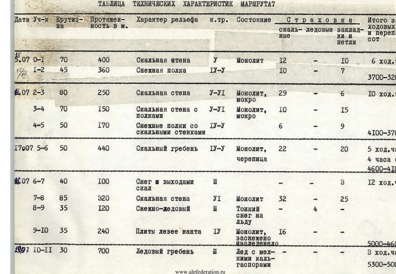
Table of technical characteristics of the route
| Date | Section | Steepness | Length in m | Character of relief | Cat. diff. | Condition | Insurance: rock | Insurance: ice | Insurance: stoppers and loops | Total for the day: climbing hours | Total for the day: height difference |
|---|---|---|---|---|---|---|---|---|---|---|---|
| 05.07 | R0–R1 | 70 | 400 | Rock wall | 5 | Monolith | 12 | — | 10 | 6 hours | 3700–3200=500 |
| R1–R2 | 45 | 360 | Snow shelf | 4-5 | 10 | — | 7 | ||||
| 06.07 | R2–R3 | 80 | 250 | Rock wall | 5-6 | Monolith, wet | 29 | — | 6 | 10 hours | 4100–3700=400 |
| R3–R4 | 70 | 150 | Rock wall with shelves | 5-6 | Monolith, wet | 10 | — | 15 | |||
| R4–R5 | 50 | 170 | Snow shelves with rock walls | 4-5 | 6 | — | 9 | ||||
| 07.07 | R5–R6 | 50 | 440 | Rock ridge | 4-5 | Monolith, imbricate | 22 | — | 20 | 5 hours + 4 hours processing | 4600–4100=500 |
| 08.07 | R6–R7 | 40 | 100 | Snow and rock outcrops | 3 | — | — | 3 | 12 hours | 5000–4600=400 | |
| R7–R8 | 85 | 320 | Rock wall | 6 | Monolith | 32 | — | 25 | |||
| R8–R9 | 35 | 120 | Snow-ice | Thin snow on ice | — | — | 4 | ||||
| R9–R10 | 35 | 240 | Slabs left of the edge | 4 | Monolith, snow-covered and icy | 16 | — | — | |||
| 09.07 | R10–R11 | 30 | 700 | Ice ridge | 3 | Ice with small calgaspores | — | — | — | 3 hours | 5300–5000=300 |
Evaluation of the route
The route is very long, for 5 climbing days. (For the first ascenders - 7 days).
The route is combined - includes:
- long sections of rocks of 6th category of difficulty;
- sections of complex steep snow;
- ice sections requiring crampons and ice pitons.
Out of all the routes of 5B category of difficulty passed by the participants, it seemed the most technically challenging and very labor-intensive. It is practically not inferior to Chapdara by Solonikov and Krumkol by Timofeev, 6B category of difficulty. It should be noted that the route is safe. Throughout the route, there was not a single case of spontaneous rockfall.
Our group, like the first ascenders, did not go to the South peak, to which most of the classified routes lead.
We believe that the route should be named as follows: "Bodkhona, N peak via N wall," and the names of the routes via the SW wall and 3rd ridge should be clarified - they lead to the S peak.