Ascent Passport
- Category — technical
- Fann Mountains
- Peak Bodhona via the S.W. wall, "Column"
- 5B category of difficulty
- Height difference: wall section: 1000 m, total: 1304 m. Length: wall section: 1018 m, total: 1498 m. Length of sections with 5–6 category of difficulty: 838 m, of which 6 category of difficulty: 273 m. Average steepness of the wall section: 79°
- Pitons driven:
| rock | bolt | chocks | ice |
|---|---|---|---|
| 23 | – | 221 | 1 |
- Team's climbing hours: 18 and days 2.
- Overnight stays: one bivouac on descent after the summit.
- Leader: alpinist, rock climber Krivulin Konstantin Vladimirovich, 1963, 1st sports category, Candidate Master of Sports.
Team members:
- Smetanin Alexander Alekseevich, 1961, 1st sports category, Candidate Master of Sports
- Kotsyuba Sergey Lvovich, 1962, 1st sports category, Candidate Master of Sports
- Ivanov Vladimir Viktorovich, 1961, 1st sports category
- Sirotkin Andrey Sergeevich, 1962, 1st sports category
- Coach: Ovsyannikov Yuri Nikolaevich, Master of Sports of the USSR.
- Approach and acclimatization: August 2, 1986. Departure for the route: August 3, 1986. Descent: August 4, 1986.
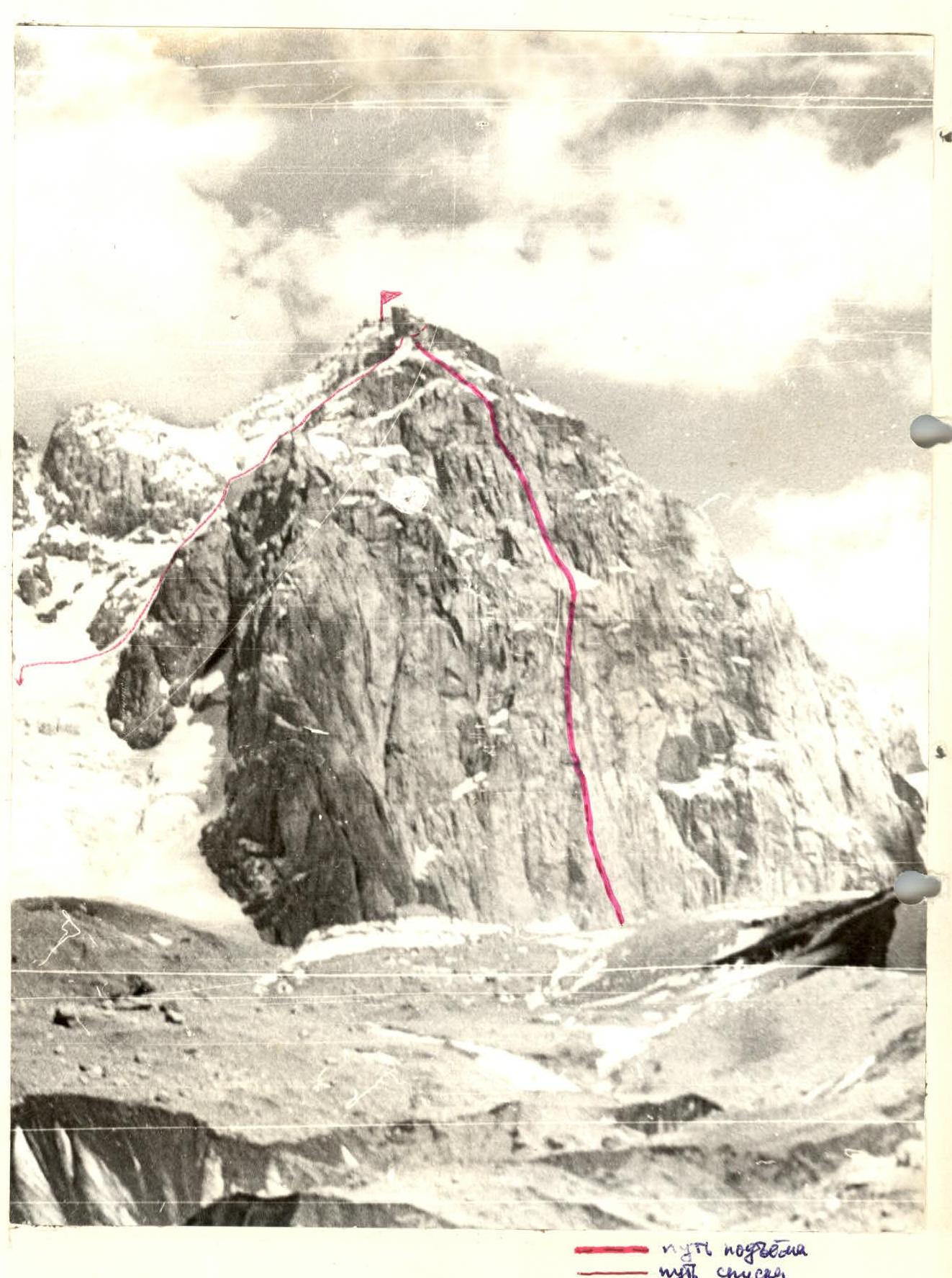
General photo of the S.W. wall of Peak Bodhona. Taken from Bodhona Glacier on August 1, 1986, at 14:00 from a distance of 1.5–2 km, lens: Industar 61, F = 52.3 mm.
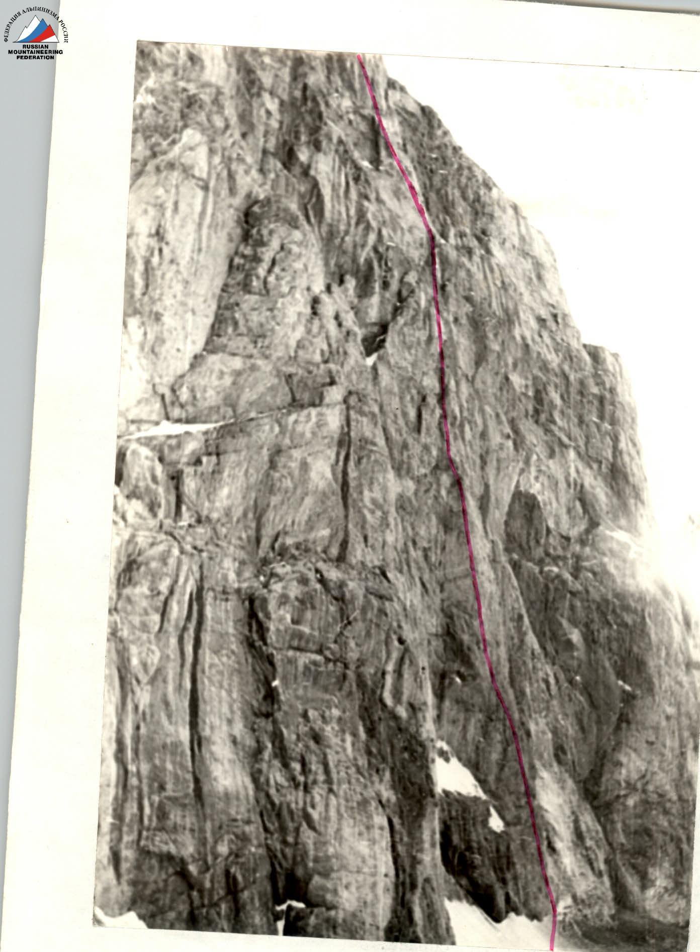
Semi-profile of the wall from the left. Taken from Bodhona Glacier from a distance of 0.5–0.7 km at 9:30, lens: Industar 61, F = 52.3 mm.
Team's Tactical Actions
The tactics for ascending Peak Bodhona included the following:
- thorough preparation for the ascent;
- reliable radio communication;
- observation of the wall before and during the ascent to Peak Zamok via the Isaenko route, 5B category of difficulty;
- preliminary processing of the majority of the "bottle";
- light and high-calorie nutrition (300 g per person per day);
- decision to ascend in a team of five, which increases the speed of movement while maintaining team mobility and safety;
- interaction between rope teams and team members;
- high ascent speed;
- predominant use of chock stones.
The relief of the wall section is characterized by difficult rock climbing, with some areas featuring a significant amount of rime ice and snow. Therefore, the team's tactics on the wall remained unchanged. The lead climber ascends on a double rope and, after securing one of the ropes, takes in the second climber with top-rope protection, who then hands over the rope and equipment to the first. The third team member ensures timely transfer of ropes and equipment from the last to the first. The fourth team member takes in the fifth with top-rope protection, who removes chocks and extracts pitons.
The lead climber was changed three times, which also helped maintain a high ascent pace, as all team members have a similar level of rock climbing proficiency.
The route is considered safe because the steep rocks provide reliable protection from occasional falling rocks.
There were no deviations from the tactical plan during the ascent, and no accidents or injuries occurred.
| – | – | – | 2 | |
|---|---|---|---|---|
| – | – | – | 5 | |
| 1 | – | – | 8 | |
| 1 | – | – | 7 | |
| 1 | – | – | 8 | |
| – | – | – | 5 | |
| 1 | – | – | 7 | |
| – | – | – | 2 | |
| 1 | – | – | 5 | |
| – | – | – | 3 | |
| 1 | – | – | 10 | |
| – | – | – | 2 | |
| – | – | – | 2 | |
| 1 | – | – | 6 | |
| – | – | – | 1 | |
| – | – | – | 3 | |
| 1 | – | – | 6 | |
| – | – | – | 2 | |
| – | – | – | 2 | |
| 1 | – | – | 7 | |
| 1 | – | – | 4 | |
| – | – | – | 2 | |
| 1 | – | – | 2 | |
| 1 | – | – | 4 | |
| – | – | – | 3 | |
| – | – | – | 3 | |
| 1 | – | – | 4 | |
| – | – | – | 2 | |
| – | – | – | 3 |
| 1 | – | – | 4 |
|---|---|---|---|
| – | – | – | 4 |
| 1 | – | – | 4 |
| – | – | – | 2 |
| – | – | – | 6 |
| – | – | – | 7 |
| – | 1 | – | 1 |
| – | – | – | 4 |
| – | – | – | 5 |
| 1 | – | – | 5 |
| – | – | – | 3 |
| 1 | – | – | 3 |
| 1 | – | – | 4 |
| – | – | – | 3 |
| – | – | – | 3 |
| – | – | – | 1 |
| 1 | – | – | 4 |
| – | – | – | 2 |
| – | – | – | 4 |
| 1 | – | – | 8 |
| 2 | – | – | 1 |
| – | – | – | 4 |
| – | – | – | 5 |
| 1 | – | – | 5 |
| – | – | – | 1 |
| – | – | – | 3 |
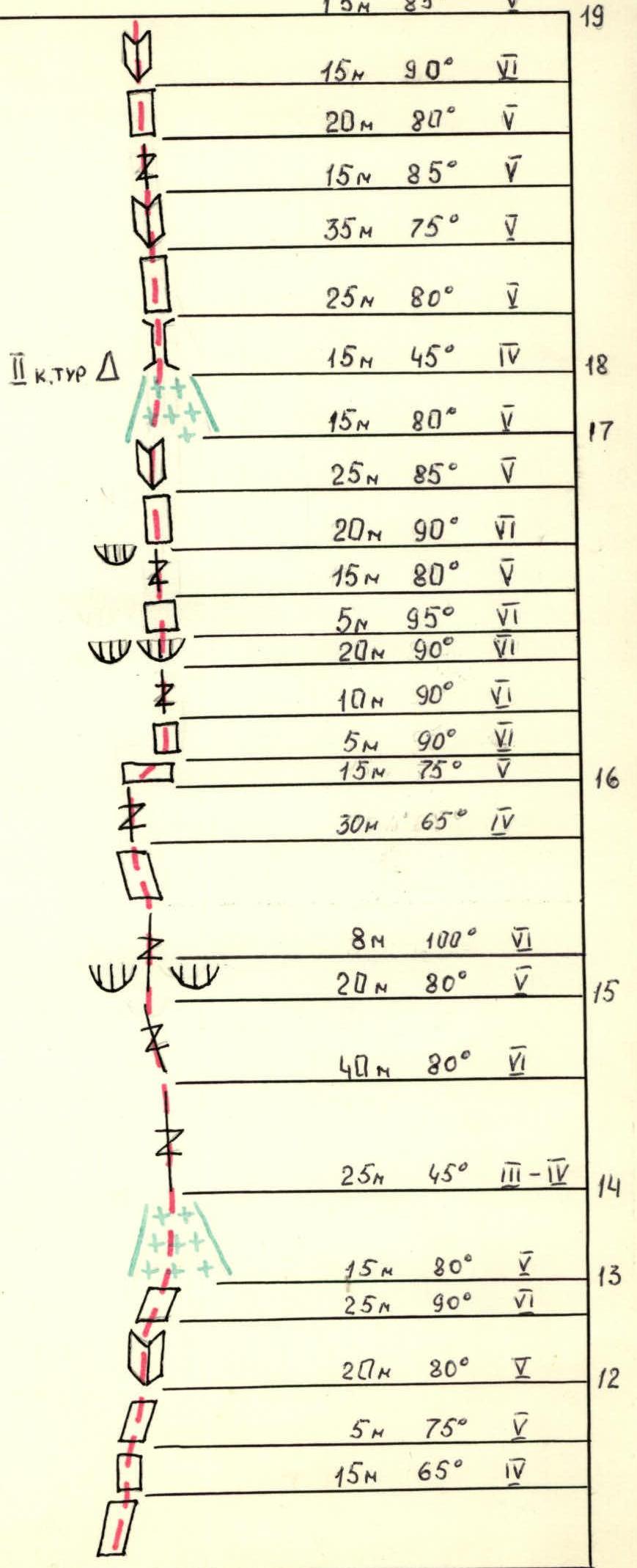

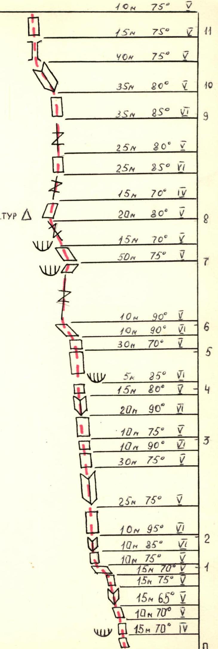
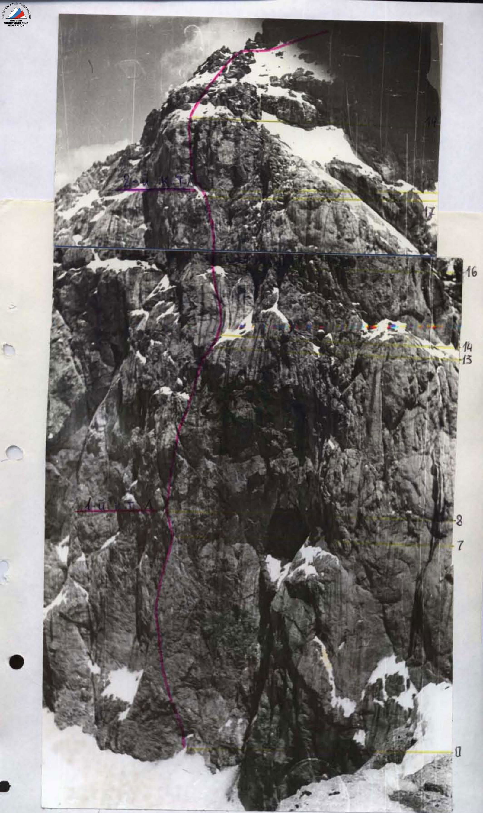
Route diagram.
Total on the route:
- Climbing hours — 18 (to the summit)
- Pitons driven: Rock 23, Ice 1, Chocks 221
- Pitons were used to organize belay stations by blocking with chocks.
Route Description by Sections. Scale 1:2000
- Section R0–R1: The wall begins immediately from the glacier; a small snow slope (10 m) can be disregarded. The steepness of the first rock section is 70°; the rocks are occasionally covered with rime ice; in the morning, the fixed rope on this section was frozen.
- Section R1–R2: A steep ten-meter wall with small holds transitions into an overhanging internal corner 10 m long.
- Section R2–R3: A 25 m wall transitions into an internal corner with rime ice, ending in a ten-meter sheer wall with difficult climbing, followed by 10 m of slightly more gentle rocks.
- Section R3–R4: This section is 40 m long, with 25 m of climbing at grade 6; the holds are not always small but are inconveniently positioned. The climbing is interesting.
- Section R4–R5: Further, a thirty-meter wall with a steepness of 70°; the relief is weakly dissected.
- Section R5–R6: This section is psychologically challenging due to its steepness and small holds, with almost no cracks. The rocks are smoothed, and the upper part is traversed with a gradual leftward trend until the first good flake is reached.
- Section R6–R7: Next is a fifty-meter crack with a steepness of 75°. The climbing is quite challenging but enjoyable; "eccentrics" are well-applied. After this section, the "bottle" ends.
- Section R7–R8: 35 m up steep rocks with large, convenient holds to the first control cairn; there is rime ice on the section. The control cairn should be in a small cave, but it is filled with ice and snow, so we hang our own cairn on the wall (photo №3).
- Section R8–R9: From the control cairn, 15 m up and to the right on rocks of average difficulty, then 25 m up a steep crack to a wall at 80°. The holds are small but sharp and convenient. Then 35 m up a steep crack with a significant amount of rime ice; it was necessary to chip ice off the holds with a rock hammer.
- Section R9–R10: Further, 35 m up steep rocks (80°); the climbing is enjoyable, and the relief is dissected.
- Section R10–R11: Up an internal corner, 40 m left and up; the rocks are of average difficulty, but rime ice complicates the climbing. The section ends with a fifteen-meter chimney; the movement is in opposition.
- Section R11–R12: The first half of the section is not very difficult, trending gradually to the right. The second half is a twenty-meter steep wall with a small number of holds.
- Section R12–R13: Further, up a sheer internal corner, 25 m; the climbing is difficult, to a wall and along it, 15 m to a snow slope. On the wall, there is rime ice.
- Section R13–R14: Up a snow slope with a steepness of 45°, 25 m. Here is a belay station.
- Section R14–R15: From the snow slope up, a forty-meter steep crack; the rocks are smoothed. Apart from the crack with smooth edges, there are almost no holds; apparently, this was once a water flow; the climbing is challenging. Then 20 m with a slight leftward trend along the same crack, but here the friction is better, so it is somewhat easier. The section ends with an overhanging eight-meter wall cut by a crack; the friction is poor, and the holds are inconveniently positioned.
- Section R15–R16: After this, 30 m up rocks of average difficulty to a fifteen-meter crack. The crack leads to a steep rock bastion.
- Section R16–R17: Up a sheer wall with small holds, 5 m to the right with a slight height gain, and then up a sheer wall, 80 m. The climbing is strenuous and challenging, to a cornice, which is traversed by climbing, and then 15 m up a steep wall with large holds. After this, a sheer twenty-meter crack; the friction is good, and it is convenient to use "eccentrics" for protection. Then 40 m up steep relief, and we reach a snow slope; at the end of the section, there is rime ice.
- Section R17–R18: A snow slope, 15 m, with a small ice section, leads us to the "green room" (photo №7). Here, on the wall, a tin can is hung from a bolt; however, there is no note inside, so we leave our note in the control cairn.
- Section R18–R19: This section was complicated by being entirely flooded with water flowing from above almost as a continuous stream. Initially, 25 m up a steep chimney, then the chimney widens significantly and turns into a large internal corner. We move to its left wall and along it, 35 m, to a steep 10-meter internal corner, through it to a crack, and to a 15-meter sheer wall with small holds; the friction is poor, and finally, a 15-meter internal corner leads us to a snow slope. Here, the wall section of the route ends; we remove our crampons and put on "vibram" shoes.
- Section R19–R20: Up a 40-meter snow slope (protection via ice axe) under a rock wall. Up rocks of average difficulty, 60 m, to a snow couloir.
- Section R20–R21:
- 60 m up a snow slope (protection via ice axe) to a snow couloir sandwiched between two rock outcrops;
- up the couloir to a rock outcrop;
- along the outcrop, initially on snow and then on a rock ledge, to the end of the wall;
- turning the corner, we ascend a simple rock slope, 140 m, to a pre-summit tower (protection via rock features);
- further, up a 40-meter wall to a gentler slope and along it to the summit.
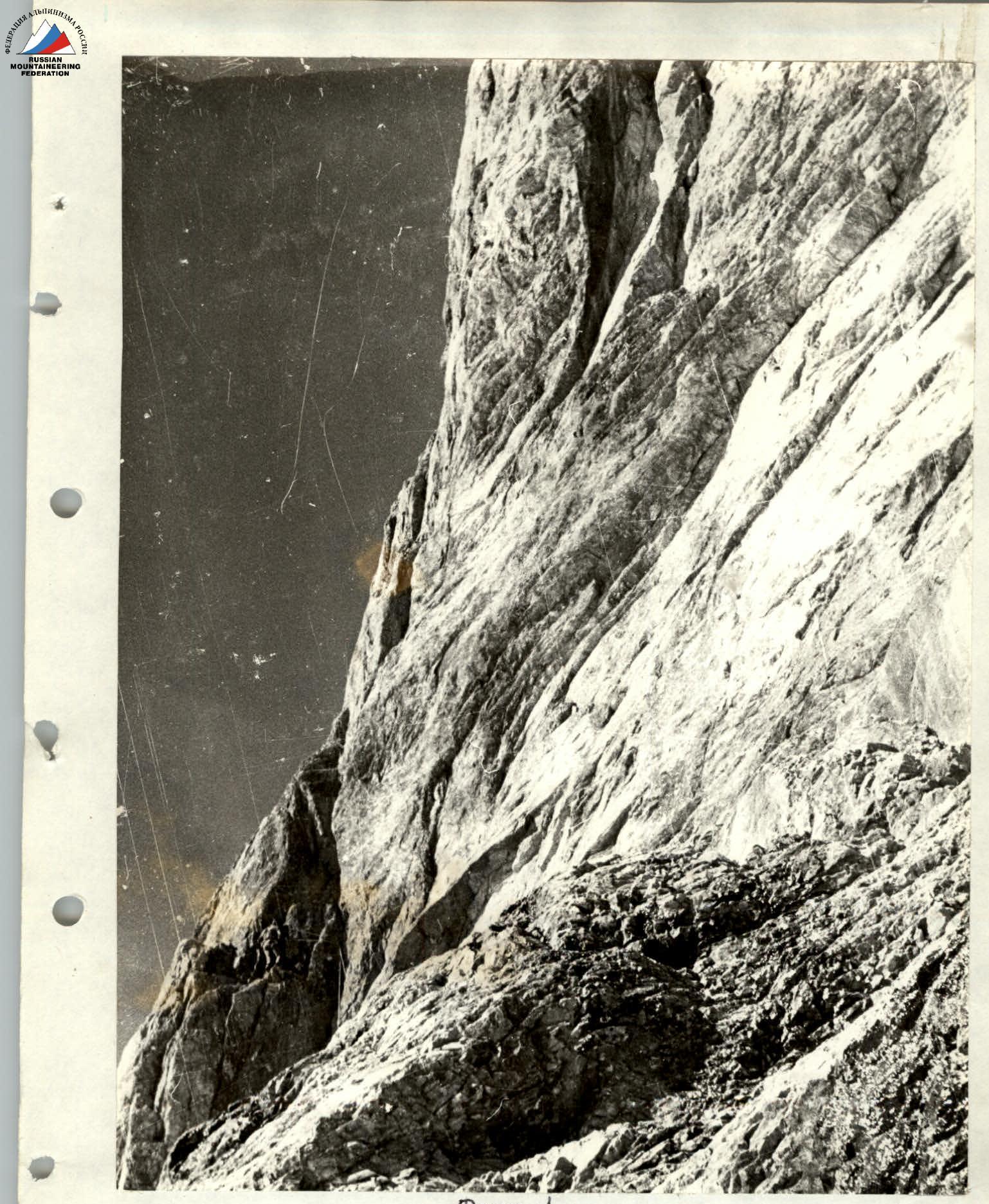
Photo 1. Lower part of the "Bottle", exit from the overhanging internal corner. Section R1–R2.
Technical photo of the route.
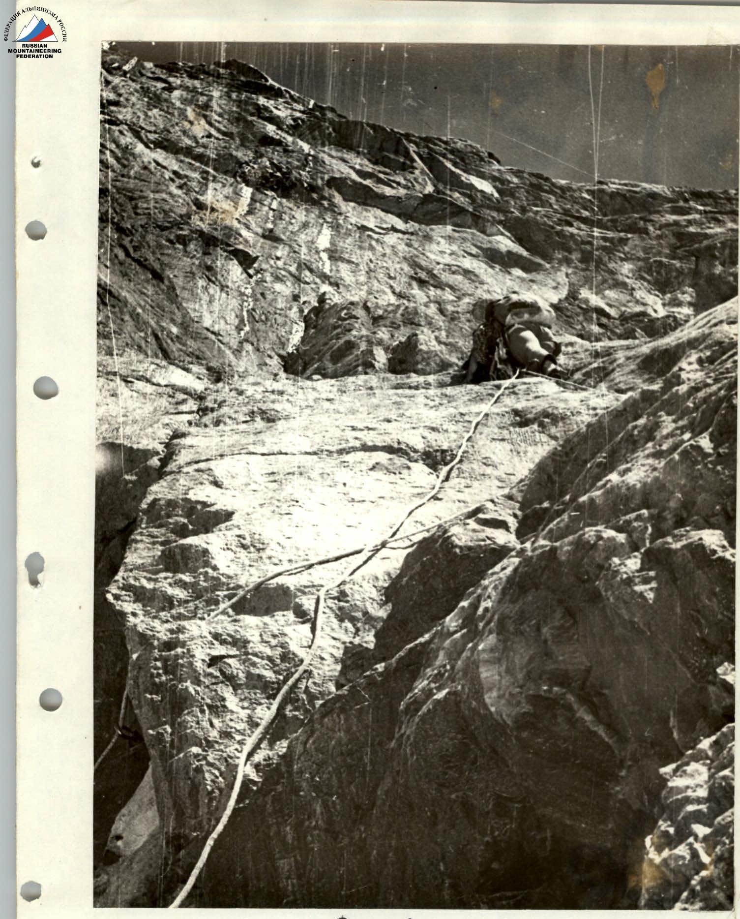
Photo 6. Approach to the start of the bastion. Section R16–R17.
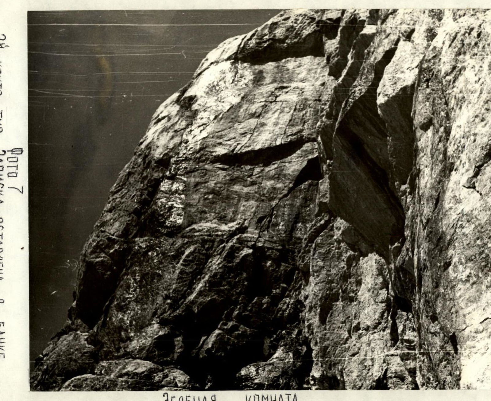
Photo 7. Control cairn. A note is left in a can on the wall. Green room.