RUSSIAN ALPINISM FEDERATION
PASSPORT
- Class of technical ascents
- Pamir-Alay, Zeravshan ridge (northern part)
- Bodkhona, 5138 m, via the right part of the western wall (N. Vlodarchik route)
- 6B category of difficulty
- Height difference from the base of the wall to the summit - 1088 m, length - 1810 m. Height difference from the base of the wall to the ridge - 935 m, length - 1210 m. Length of sections with 5-6 difficulty category - 945 m. Average steepness of main sections - 71° (4150-4985), including 6th category: 87° (4200-4270), 85° (4330-4380), 85° (4395-4410), 87° (4475-4495), 62° (4505-4520), 92° (4660-4685), 87° (4785-4885).
- Pitons driven:
| Rock | Bolt | Nuts | Ice |
|---|---|---|---|
| 261 | 0 | 50 | 0 |
| 39 | 17 |
-
Team's walking hours: 39.5, and days - 3.
-
Nights spent - 3, all with tent platforms, water (ice) available.
-
Team leader: Nikolai Gennadievich Sekachev, Candidate for Master of Sport
Members:
- Oleg Ivanovich Abramov, Candidate for Master of Sport
- Valerian Vyacheslavovich Startsev, Candidate for Master of Sport
- Alexander Antonovich Timofeev, Candidate for Master of Sport
-
Coach: Vadim Sergeevich Rublev
-
Approach to the route - July 23, 1984
Summit - July 25, 1984 Descent - July 26, 1984
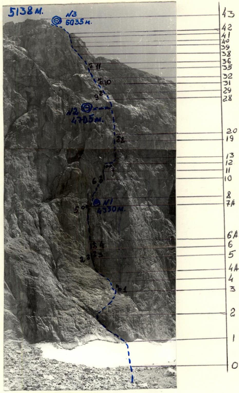
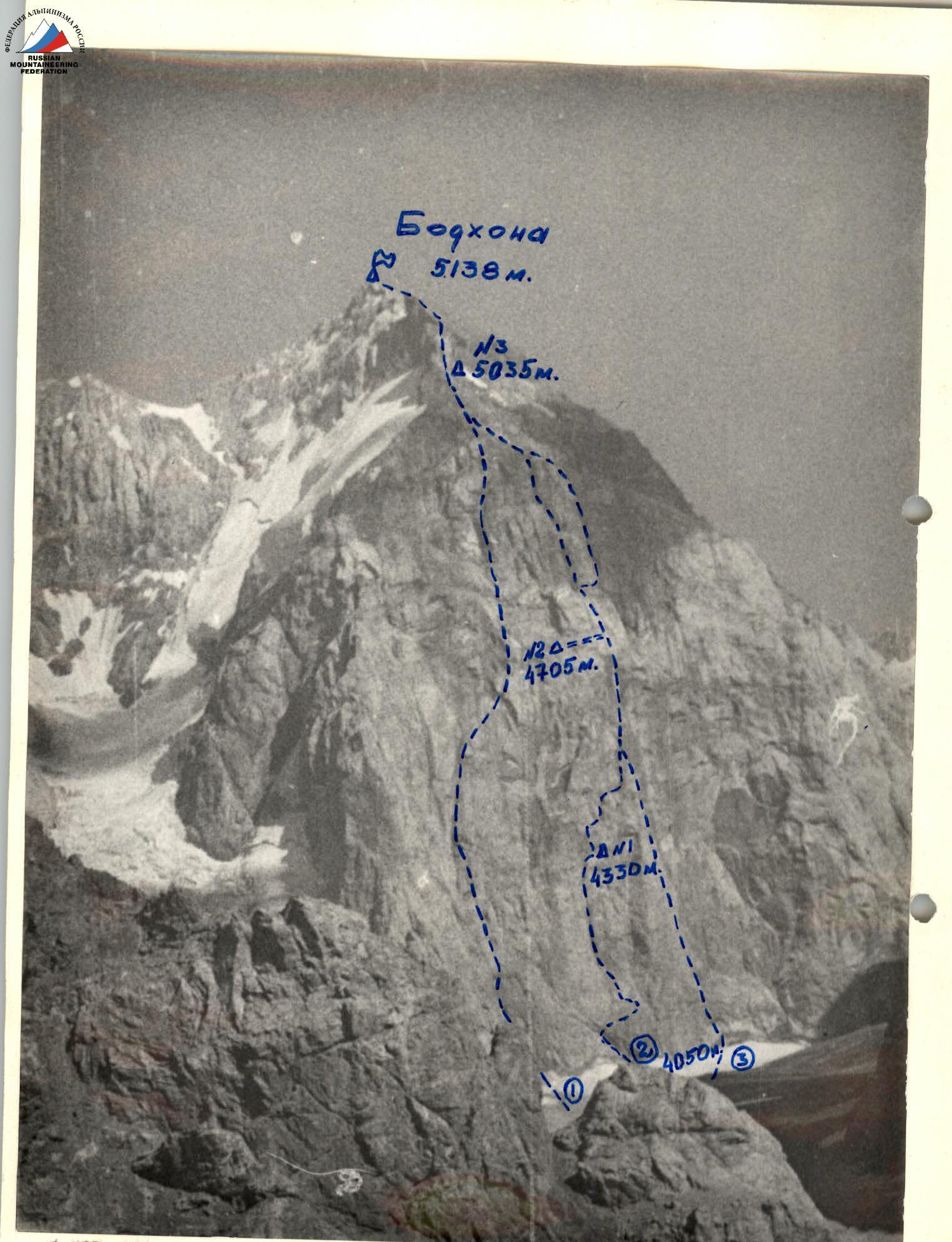 I — F. Zhitinev's route via the left part of the western wall, 2 — team route (N. Vlodarchik's) via the right part of the western wall, 3 — A. Kolchin's route via the right part of the western wall. Photo taken on July 15, 1984, at 17:00 with a Helios-44 lens (focal length 58 mm). Distance to the object 8-9 km, shooting point #3, height - 4000 m.
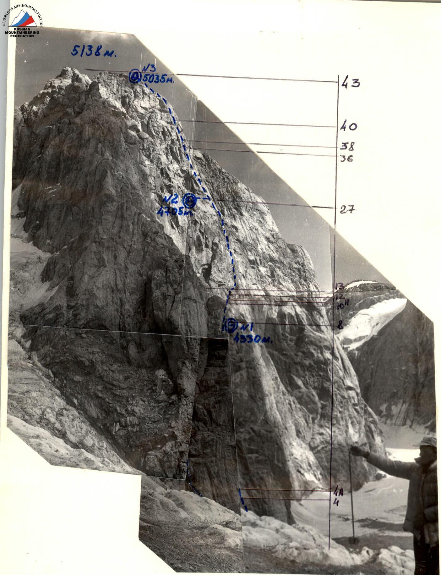 Semi-profile of the wall from the left. Photos taken on July 11, 1984, at 16:30 with a Helios-44 lens (focal length 58 mm) from a distance of 1-1.5 km. Shooting point #2 on the area diagram, height - 4100 m.
Team's Tactical Actions
During the ascent, 2 deviations from the tactical plan were made:
-
The first night's bivouac was set up on a ledge to the right of section R7A-R8 instead of the planned "mitten" outcropping due to the team's 2-hour delay before section R7A-R8 from 14:30 to 16:30 caused by rockfall.
-
The summit was reached almost 7 hours later than planned (July 25, 1984, at 20:20 instead of 13:30) due to:
- the accumulated delay on the first day
- a 4-hour delay due to bad weather before section R36-R37 (at 13:30, wet snow started, and movement resumed at 17:30 when the rocks dried).
The organization of movement on the first day, July 23, 1984, was as follows: lead climber O. Abramov ascended sections R3-R9 on a double rope (photo 37), belayed by N. Sekachev, who then ascended via the fixed ropes with upper belay, driving in some pitons; third to ascend via the fixed ropes was A. Timofeev, and last to ascend via the fixed ropes, removing all pitons, was V. Startsev.
On the second day, the organization and movement scheme were similar, but V. Startsev was the lead climber (sections R9-R27), followed by N. Sekachev, and O. Abramov brought up the rear.
On the third day, July 25, 1984, the organization and movement scheme remained the same, but N. Sekachev led (sections R27-R42, photo II), followed by O. Abramov, and V. Startsev brought up the rear.
Sections that did not pose significant difficulties (R0-R3, R18-R19, R40-R41, R42-R43) were ascended by teams N. Sekachev - O. Abramov and V. Startsev - A. Timofeev independently, utilizing pitons driven by the previous team.
Preliminary processing (2 ropes) was carried out on July 23, 1984, at the end of the day on section R8-R9 by the team O. Abramov - N. Sekachev.
Fixed ropes were set up on sections:
- R3-R18
- R19-R40
- R41-R42 (photos 2, 6, 8).
For belaying and securing fixed ropes, a belay station consisting of three linked pitons was established.
Practically all daylight hours were utilized for movement. Hot meals were organized in the morning and evening at the bivouacs, and lunch breaks were taken during pauses in the ascent or forced halts due to weather (third day) and rockfall (first day). An exception was the second day, when a one-hour break was taken for a hot meal for the entire team. Comfortable bivouac sites with tents allowed for recovery.
Safety measures included:
- ascending rockfall-prone sections R1-R3 early (around 6:00),
- ascending all sections with 5 and 6 difficulty categories first on a double rope (photos 3, II)
- establishing fixed ropes on such sections (photos 2, 6, 8),
- using upper belay when the second and fourth climbers ascended via fixed ropes, and in particularly complex and hazardous areas, also for the third climber,
- halting movement upon visual observation of bad weather or rockfall,
- establishing belay stations on all points with three linked pitons.
Challenging tasks included navigating complex walls and cornices with few holds. Solutions involved using artificial aids (IT), platforms, and ladders (photos 3, 8). To speed up piton driving, a "chain" method was used, accelerating the last climber's progress and, consequently, the entire team's.
During bad weather (snowfall on section R36-R37), the team found themselves on a complex section and chose not to ascend the wet 6B category rocks. The team considered the short duration of the bad weather and opted not to use bolt climbing techniques.
Visual and radio communication (using a "Dnepr" radio station) with observers was maintained according to a schedule three times a day: 10:00, 14:00, 18:00. Additional communication sessions were scheduled: July 24, 1984, at 21:00 and July 25, 1984, at 21:00.
In case of an emergency or radio failure, the team was equipped with:
- a flare gun and flares,
- spare power for the radio station.
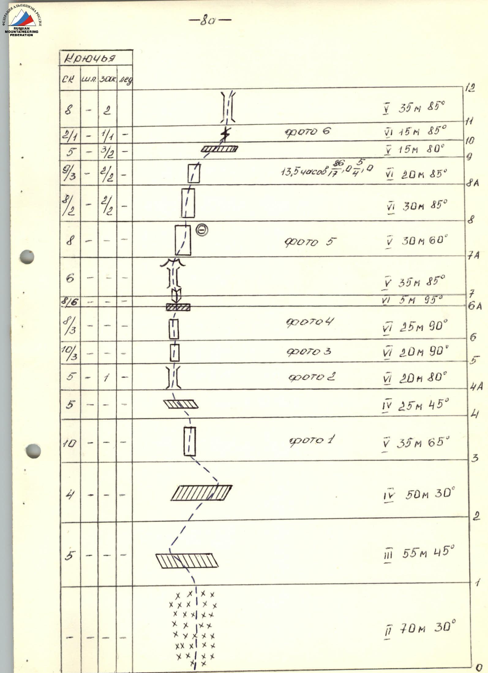
| Section # | Rock | Bolt | Nuts | Ice | Photo | Length | Steepness | Remarks |
|---|---|---|---|---|---|---|---|---|
| R0 | 70 m | 30° | ||||||
| R1 | 5 | 55 m | 45° | |||||
| R2 | 4 | 50 m | 30° | |||||
| R3 | 10 | photo 1 | 35 m | 65° | ||||
| R4 | 5 | 25 m | 45° | |||||
| R4A | 5 | 1 | photo 2 | 20 m | 80° | |||
| R5 | 10 | 3 | photo 3 | 20 m | 90° | |||
| R6 | 8 | 3 | photo 4 | 25 m | 90° | |||
| R6A | 8/6 | 3 | 5 m | 95° | ||||
| R7 | 6 | 35 m | 85° | |||||
| R7A | 30 m | 60° | ||||||
| R8 | 8 | photo 5 | 30 m | 60° | ||||
| R8A | 9/2 | 3/2 | 30 m | 85° | ||||
| R9 | 9/3 | 2/2 | 20 m | 85° | 13.5 h | |||
| R10 | 5 | 3/2 | 2 | 15 m | 80° | |||
| R11 | 2/1 | 1/1 | photo 6 | 15 m | 85° | |||
| R12 | 8 | 2 | 35 m | 85° | ||||
| R13 | 8 | 2 | photo 7 | 35 m | 70° | |||
| R14 | 4/2 | 15 m | 85° | |||||
| R15 | 3/3 | 5 m | 95° | |||||
| R16 | 5 | 10 m | 60° | |||||
| R17 | 2 | 8 m | 65° | |||||
| R18 | 6/4 | 2/2 | 10 m | 60° | ||||
| R19 | 10 | 60 m | 30° | |||||
| R20 | 4 | 2 | photo 8 | 20 m | 70° | |||
| R21 | 8 | 30 m | 65° | |||||
| R22 | 8 | 35 m | 90° | |||||
| R23 | 7 | 40 m | 50° | |||||
| R24 | 2/2 | 2/2 | 8 m | 95° | ||||
| R25 | 3/3 | 2/2 | 15 m | 90° | ||||
| R26 | 3 | 15 m | 60° | |||||
| R27 | 14 | 10 m | 55° | 13 h | ||||
| R28 | 4 | 10 m | 85° | |||||
| R29 | 10/3 | 3/0 | photo 9 | 30 m | 90° | |||
| R30 | 2 | 8 m | 90° | |||||
| R31 | 1 | 4 m | 85° | |||||
| R32 | 10 | 2 | photo 10 | 45 m | 85° | |||
| R33 | 2/2 | 6/2 | 10 m | 90° | ||||
| R34 | 7 | 2 | 35 m | 60° | ||||
| R35 | 4 | 20 m | 65° | |||||
| R36 | 4 | 2 | 15 m | 90° | ||||
| R37 | 10/2 | 2/1 | 20 m | 95° | ||||
| R38 | 2 | 5 | 35 m | 70° | ||||
| R39 | 10 | 10 m | 85° | |||||
| R40 | 3 | 30 m | 30° | |||||
| R41 | 4 | 1 | 8 m | 90° | ||||
| R42 | 3 | 600 m | 15° | |||||
| R43 |
Description of the Route by Sections
Section R3-R4 (photo 1). A 35-meter smoothed wall was ascended by lead climber O. Abramov via free climbing. At the end of the section, a belay station was established.
Section R4A-R5 (photo 2). A chimney with smooth, wet walls, at the end of which is the 1st control cairn. Here, rucksacks were hauled up. Belay stations were located at the start and at the control cairn.
Section R5-R6 (photo 3). A smooth wall with few holds was ascended by O. Abramov using artificial aids (IT) and a platform. Rucksacks were not hauled from this section onwards. At the end, a belay station was established.
Section R6-R6A (photo 4). A smooth wall was ascended by O. Abramov using IT (platform, ladders). At the end, a 1.5-meter cornice was traversed on ladders. Before the cornice, a belay station was established.
Section R6A-R7. An overhanging internal corner was ascended by O. Abramov using IT (ladders).
Section R7-R7A. A damp chimney with a series of overhanging cornices led into a grotto, at the back of which was suspended a second control cairn in a tin can. Here, a belay station was established. Movement was halted for 2 hours due to rockfall on the next section.
Section R7A-R8 (photo 5). From the grotto, an exit was made to the right along a 60-degree grey 30-meter slab. At the end of the slab, a ledge with a comfortable bivouac site was found. Here, a belay station was established.
Section R8-R8A. A grey-colored wall with overhanging sections was ascended by O. Abramov mainly via minimal climbing and partially using IT (ladders). At the end, a belay station was established.
Section R8A-R9. A traverse to the right and upwards along a wall with few holds was made. Very difficult climbing, with O. Abramov traversing overhangs on ladders. At the end, a belay station was established.
Section R9-R10. A crescent-shaped crack and a small inclined ledge, which jutted out from the wall, led to the base of a cleft going up to the "mitten" outcropping. Lead climber V. Startsev used ladders here.
Section R10-R11 (photo 6). The start of the ascent onto the "mitten" via a cleft with few cracks. Climbing was difficult. V. Startsev used IT. At the end, a belay station was established.
Section R11-R12. The cleft turned into a chimney, widening at the top. The chimney was iced and became damp during the day. V. Startsev ascended on opposition. On the "mitten," 2 control cairns were found (one was dismantled by the team). Comfortable bivouacs were possible here (to the right, 1 rope length away, there was ice). On the "mitten," a belay station was established.
Section R12-R13 (photo 7). To the right and upwards onto a wide internal corner, which V. Startsev ascended on the right side (water flowed from above the overhang). At the end, a belay station was established.
Section R13-R14. A 15-meter chimney presented difficulty in overcoming 2 small cornices.
Section R14-R16. A negative 5-meter wall was traversed on ladders, leading onto a steep rocky ridge. The rocks were difficult, with almost no holds. V. Startsev ascended this section using ladders and friction. At the end, a belay station was established.
Section R16-R17. An 8-meter rock face of red color without cracks was ascended by V. Startsev using friction via free climbing.
Section R17-R18. A damp cleft was ascended by V. Startsev using ladders.
Section R19-R21 (photo 8). A wall with 2 clefts and protruding smoothed rock faces was ascended by V. Startsev via free climbing. Belay stations were established in the middle and at the end.
Section R21-R22. A sheer wall was ascended by V. Startsev via free climbing. At the end, a belay station was established.
Section R22-R23. A traverse to the right along rocks resembling "ram's foreheads" was made. At the end, a belay station was established.
Section R23-R24. A wall with a slit was ascended by V. Startsev via free climbing (difficult) and further using ladders.
Section R24-R25. A narrow chimney ending in a cornice was ascended. Very difficult climbing using ladders.
Section R25-R27. An inclined ledge led into a steep, short couloir. Here, a belay station was established. After traversing the couloir, the route deviated to the left along a ledge for 2 rope lengths - a convenient bivouac site. After the bivouac, the team returned to the route via the fixed ropes.
Section R27-R28. A traverse along a small ledge to the right under an overhanging wall was made. At the end, a belay station was established.
Section R28-R29. A sheer wall with three cornices was ascended. Very difficult climbing using a platform and ladders led N. Sekachev to a small platform - here, a belay station was established.
Section R29-R31. A sheer wall with a cleft in the middle was ascended. Very difficult. N. Sekachev ascended via free climbing. Further, an internal corner formed by the wall and a cornice was ascended by N. Sekachev via free climbing (very difficult) under the internal corner.
Section R31-R32. The internal corner was ascended by N. Sekachev along the right side via free climbing (very difficult). In the middle, a belay station was established.
Section R32-R33. A vertical chimney with a "plug" was ascended by N. Sekachev on ladders, first along the left wall, then into the chimney, and further upwards on the "plug" using opposition.
Section R33-R34. A wide chimney narrowing at the top with a "plug" of loose rocks was ascended via free climbing. Belay stations were established at the start and end.
Section R34-R35. From the chimney, under an overhanging wall, further to the right and upwards along a series of clefts. N. Sekachev ascended via free climbing (partially very difficult - juts out). At the end, a belay station was established.
Section R35-R36 (photo II). A vertical wall with increasing steepness at the top was ascended by N. Sekachev via free climbing. At the end, a transition was made onto a ledge under an overhanging wall of dark-red color. Here, a belay station was established. Movement was halted due to bad weather for 4 hours.
Section R36-R37. A wall with 2 vertical cracks was ascended by N. Sekachev via free climbing (very difficult). The wall led onto an inclined platform. Here, a belay station was established.
Section R37-R38. A monolithic overhanging wall with a vertical crack was ascended by N. Sekachev using ladders. At the end, a belay station was established.
Section R38-R39. Rocks resembling "ram's foreheads" with a cleft in the middle were ascended by N. Sekachev via free climbing using nuts. At the end, a belay station was established.
Section R39-R40. A destroyed wall with an indistinct internal corner was ascended by N. Sekachev via free climbing.
Section R41-R42. A sheer wall leading onto the pre-summit ridge was ascended by N. Sekachev via free climbing.
Technical Photography of the Route
Photo taken on July 23, 1984, at 17:00.
Lens: Helios-44
Focal length: 58 mm
Shooting distance: 1 km
Shooting point: #1 on the diagram
Height of shooting point: 4050 m www.alpfederation.ru↗