Climbing Passport
I. Category — technical 2. Fann Mountains 3. Bodkhona peak via S.W. wall (Kolonna?) 4. 5B category of difficulty 5. Height difference: wall part: 1000 m, total: 1304 m. Length: wall part: 1018 m, total: 1498 m. Length of 5–6 category of difficulty sections: 838 m, of which 6 category of difficulty: 273 m. Average steepness of the route's wall part: 79° 6. Pitons driven:
| rock | bolt | chocks | ice screws |
|---|---|---|---|
| 23 | - | 221 | 1 |
- Team's climbing hours: 18 and days 2.
- Overnights: one bivouac on descent after the summit.
- Team leader: alp. rock climbing. Krivulin Konstantin Vladimirovich, 1963, I CMS Team members:
- Smetanin Aleksandr Alekseyevich, 1961, I CMS
- Kotsyuba Sergey Lvovich, 1962, I CMS
- Ivanov Vladimir Viktorovich, 1961, II
- Sirotkin Andrey Sergeyevich, 1962, II
- Coach: Ovsyannikov Yuriy Nikolayevich, Master of Sports of the USSR
- Approach and processing: August 2, 1986.
Start of the route (summit): August 3, 1986.
Descent: August 4, 1986.
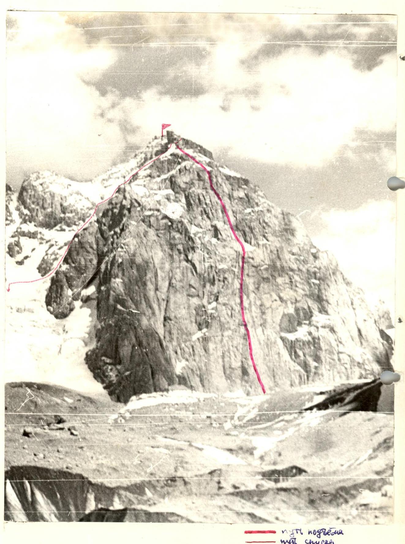
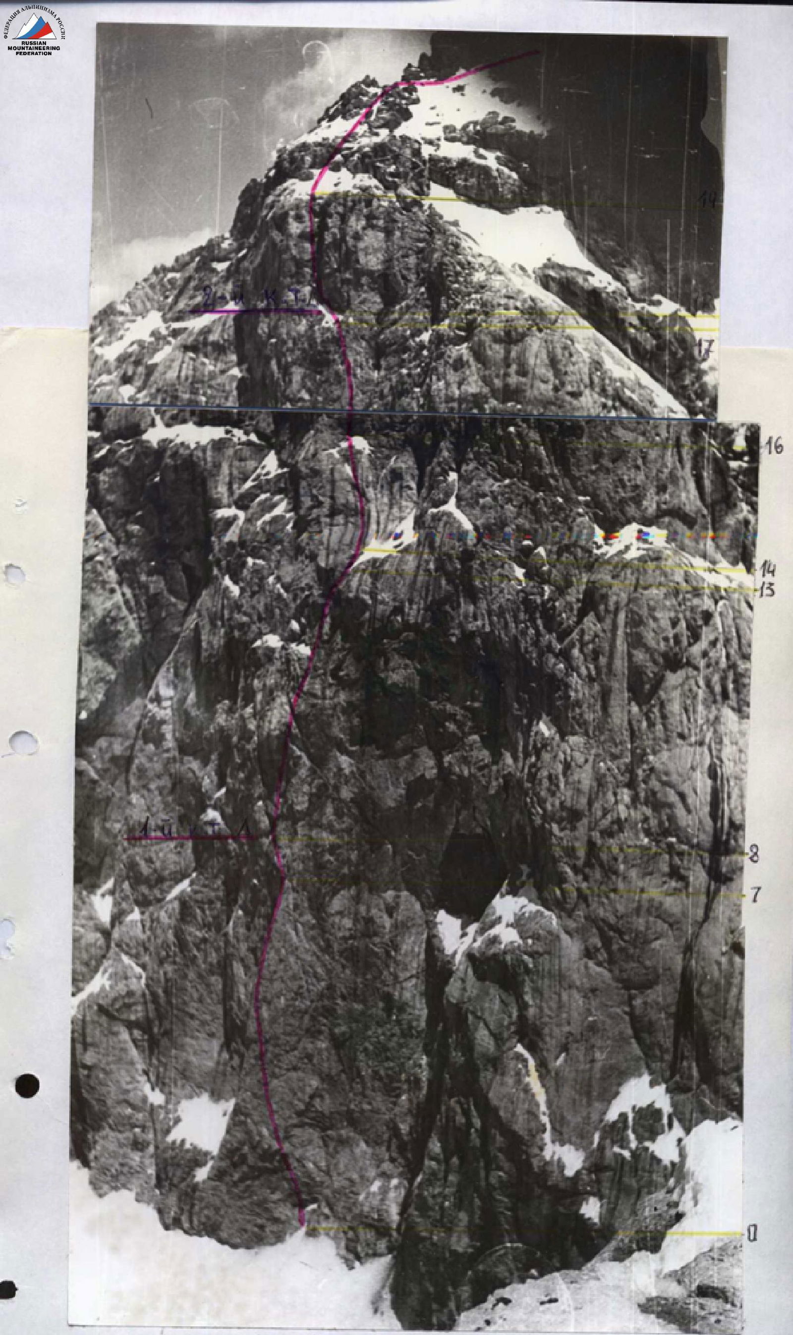
General photo of the S.W. wall of Bodkhona peak. The photo was taken from Bodkhona glacier on August 1, 1986, at 14:00 from a distance of 1.5–2 km. Lens: Industar 61, F = 52.3 mm.
It is not possible to take a photo of the wall's semi-profile on the right.

Semi-profile of the wall on the left. The photo was taken from Bodkhona glacier from a distance of 0.5–0.7 km at 9:30. Lens: Industar 61, F = 52.3 mm.
Tactical Actions of the Team
The tactics for ascending Bodkhona peak included the following:
- thorough preparation for the ascent;
- reliable radio communication;
- observation of the wall before and during the ascent to Zamok peak via the Isaenko route, 5B category of difficulty;
- preliminary processing of most of the "bottle" — light and calorie-rich nutrition (300 g per person per day) — decision to go on the route with five people, which increases the speed of movement while maintaining team mobility and safety;
- interaction between rope teams;
- interaction between team members;
- high speed of ascent;
- predominant use of chock stones.
The terrain of the wall part of the route consists of rocks that are difficult to climb. In some places, there is a significant amount of ice and snow accretion, so the team's movement tactics on the wall did not change.
Movement scheme:
- The lead climber ascends on a double rope and, after securing one of the ropes, belays the second climber from above.
- The second climber brings the rope and equipment to the lead climber.
- The third climber ensures timely transfer of ropes and equipment from the last climber to the first.
- The fourth climber belays the fifth from above, who removes chocks and extracts pitons.
The lead climber was changed three times, which also helped maintain a high pace of ascent since all team members have a similar level of rock climbing proficiency. The route is safe because the steep rocks provide reliable protection from falling rocks.
During the ascent, there were no deviations from the tactical plan. No falls or injuries occurred.
| - | - | - | 2 | | :---: | :---: | :---: | : | | - | - | - | 5 | | 1 | - | - | 8 | | 1 | - | - | 7 | | 1 | - | - | 8 | | - | - | - | 5 | | 1 | - | - | 7 | | - | - | - | 2 | | 1 | - | - | 5 | | - | - | - | 3 | | 1 | - | - | 10 | | - | - | - | 2 | | - | - | - | 2 | | 1 | - | - | 6 | | - | - | - | 1 | | - | - | - | 3 | | 1 | - | - | 6 | | - | - | - | 2 | | - | - | - | 2 | | 1 | - | - | 7 | | 1 | - | - | 4 | | - | - | - | 2 | | 1 | - | - | 2 | | 1 | - | - | 4 | | - | - | - | 3 | | - | - | - | 3 | | 1 | - | - | 4 | | - | - | - | 2 | | - | - | - | 3 |
| - | - | - | 4 |
|---|---|---|---|
| - | - | - | 4 |
| 1 | - | - | 4 |
| - | - | - | 2 |
| - | - | - | 6 |
| - | - | - | 7 |
| - | 1 | - | 1 |
| - | - | - | 4 |
| - | - | - | 5 |
| 1 | - | - | 5 |
| - | - | - | 3 |
| 1 | - | - | 3 |
| 1 | - | - | 4 |
| - | - | - | 3 |
| - | - | - | 3 |
| - | - | - | 1 |
| 1 | - | - | 4 |
| - | - | - | 2 |
| - | - | - | 4 |
| 1 | - | - | 8 |
| 2 | - | - | 1 |
| - | - | - | 4 |
| - | - | - | 5 |
| 1 | - | - | 5 |
| - | - | - | 1 |
| - | - | - | 3 |


Total on the route:
- Climbing hours — 18 (to the summit)
- Pitons driven: rock 23, bolt —, chocks 221, ice screws 1. Pitons were used to organize belay stations by blocking with chocks.
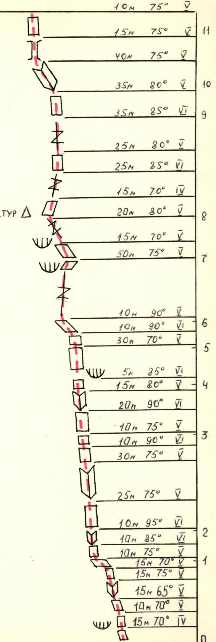
M 1:2000 Route Description by Sections
-
Section R0–R1. The wall starts immediately from the glacier; a small snow slope (10 m) can be disregarded. The steepness of the first rock section is 70°; rocks are местами covered with ice accretion; in the morning, the fixed rope on this section was frozen.
-
Section R1–R2. A steep ten-meter wall with small holds turns into an overhanging inner corner 10 m long.
-
Section R2–R3. A 25 m wall turns into an inner corner with ice accretion, ending with a ten-meter steep wall with difficult climbing, followed by 10 m on somewhat gentler rocks.
-
Section R3–R4. This section is 40 m long, of which 25 m is climbing of 6 category of difficulty; holds are not always small but are inconveniently located. Climbing is interesting.
-
Section R4–R5. Further, along a thirty-meter wall with a steepness of 70°, the relief is weakly articulated.
-
Section R5–R6. This section is of a psychological nature: with great steepness and small holds, there are almost no cracks. Rocks are smoothed, and the upper part is climbed with a gradual shift to the left until the first good flake appears.
-
Section R6–R7. Next is a fifty-meter crack with a steepness of 75°; climbing is quite difficult but pleasant; "eccentrics" are used effectively. After this section, the "bottle" ends.
-
Section R7–R8. Along steep rocks with large, convenient holds, 35 m to the first control cairn; there is ice accretion on the section. The control cairn should be in a small cave, but it is filled with ice and snow, so we hang our own cairn on the wall (photo № 3).
-
Section R8–R9. From the control cairn, 15 m to the right and up along rocks of medium difficulty, then along a steep crack 25 m to a wall of 80°, holds are small but sharp and convenient. Then 35 m along a steep crack with a large amount of ice accretion; it was necessary to chip ice from holds with a rock hammer.
-
Section R9–R10. Further, 35 m along steep rocks (80°), climbing is pleasant, relief is articulated.
-
Section R10–R11. Along an inner corner 40 m to the left and up, rocks are of medium difficulty, but ice accretion complicates climbing. The section ends with a fifteen-meter chimney, movement is in opposition.
-
Section R11–R12. In the first half of the section, climbing is not very difficult, with a gradual shift to the right; the second half is a twenty-meter steep wall with a small number of holds.
-
Section R12–R13. Further, along a steep inner corner 25 m, climbing is difficult, to a wall and along it 15 m to a snow slope. On the wall — ice accretion.
-
Section R13–R14. Along a snow slope with a steepness of 45°, 25 m. Here is a belay station.
-
Section R14–R15. From the snow slope up — a forty-meter steep crack, rocks are smoothed. Besides the crack with smooth edges, there are almost no holds; apparently, there was a water flow here earlier; climbing is difficult. Then 20 m with a slight shift to the left along the same crack, but here friction is better, so it is easier to climb. The section ends with an overhanging eight-meter wall cut by a crack, friction is poor, holds are inconveniently located.
-
Section R15–R16. After this — along rocks of medium difficulty to a fifteen-meter crack 30 m. The crack leads to a steep rock bastion.
-
Section R16–R17. Along a steep wall with small holds 5 m to the right with a slight gain in height and further up along a steep wall 80 m, climbing is tense, difficult, to a cornice, which is climbed, and then 15 m along a steep wall with large holds. After this — a steep twenty-meter crack, friction is good, it is convenient to use "eccentrics" for belaying. Then 40 m along steep terrain, and we reach a snow slope; at the end of the section — ice accretion.
-
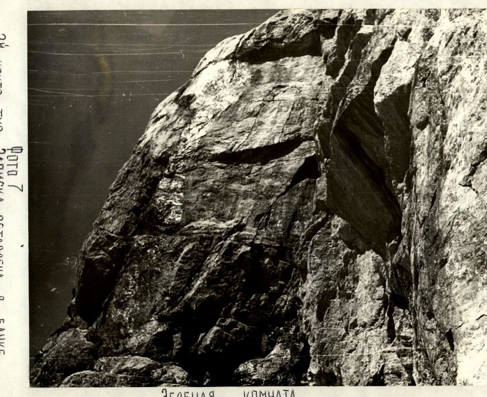
Section R17–R18. A snow fifteen-meter slope, with a small ice section, leads us to the "green room" (photo № 7). Here, on the wall, a tin can is hung on a bolt, but there is no note in it, so we leave our note in the control cairn.
-
Section R18–R19. This section was complicated by the fact that it was entirely flooded with water flowing from above almost as a continuous stream. First, 25 m along a steep chimney, then the chimney widens significantly and turns into a large inner corner. We move to its left wall and along it 35 m to a steep 10-meter inner corner, through it along a crack to a 15-meter steep wall with small holds, friction is poor, and finally, a 15-meter inner corner leads us to a snow slope; here the wall part of the route ends; we remove our approach shoes and put on "Vibram" boots.
-
Section R19–R20. Along a 40-meter snow slope (belaying through an ice axe) under a rock wall. Along rocks of medium difficulty 60 m to a snow slope.
-
Section R20–R21. 60 m along a snow slope (belaying through an ice axe) to a snow couloir sandwiched between two rock islands and along it to a rock rise, along which first on snow and then on a rock ledge to the end of the wall, then we turn around the corner and ascend along a simple rock slope 140 m to a pre-summit tower (belaying to protrusions). Further along a 40-meter wall to a gentler slope and along it to the summit.
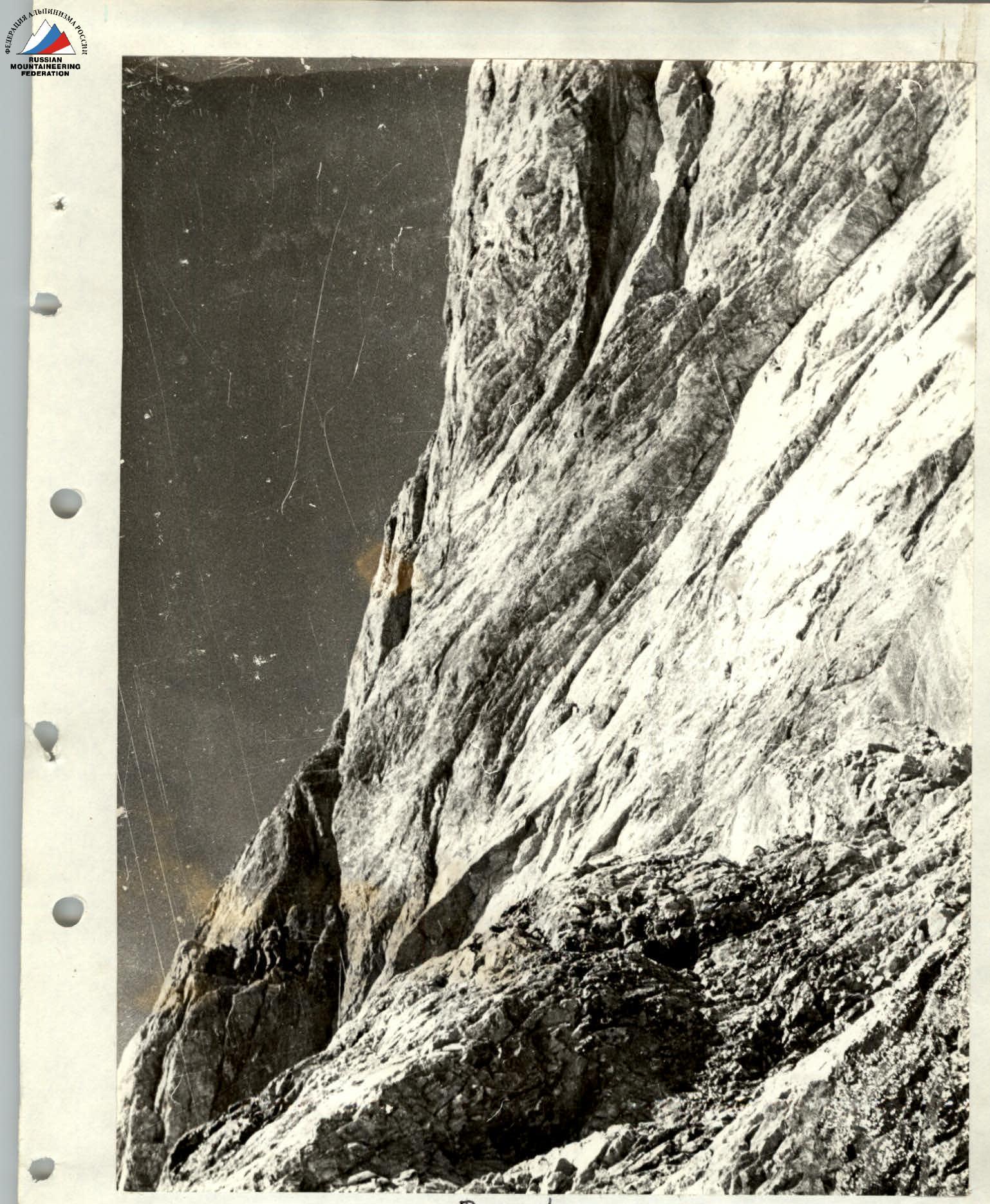
Photo 1. Lower part of the "Bottle", exit from the overhanging inner corner. Section R1–R2.
Technical photo of the route.

Photo 6. Exit to the beginning of the bastion. Section R16–R17.
Photo 7. 2nd control cairn. Note left in a tin can on the wall. "Green room".