Ascent Certificate
Technical category. Ascent area — Fann Mountains, Artuch valley, Aurongdag peak, height 4573 m, route via the northeast face. Route category 5B.
Route characteristics:
- height difference — 980 m;
- average slope — 74°;
- length of sections with 5B category difficulty – 520 m.
Pitons hammered:
- rock — 112;
- ice — —;
- bolt — —;
Total: 112 pitons. Number of climbing hours — 16. Number of overnight stays — 2 (on ledges). Team:
- Azarev I.A. Candidate for Master of Sports, instructor — team leader;
- Savchuk V.A. — participant; Candidate for Master of Sports, instructor;
- Yakovlev V.S. Candidate for Master of Sports, instructor — participant;
- Kharinyak I.V. Candidate for Master of Sports, trainee — « — »;
- Kuzmuk V.V. Candidate for Master of Sports, trainee — « — »;
- Pomazuev V.V. Candidate for Master of Sports, instructor — « — ».
Team coach — Ovcharov V.V. Departure to the route — June 27, 1977. Return to base camp — June 30, 1977.
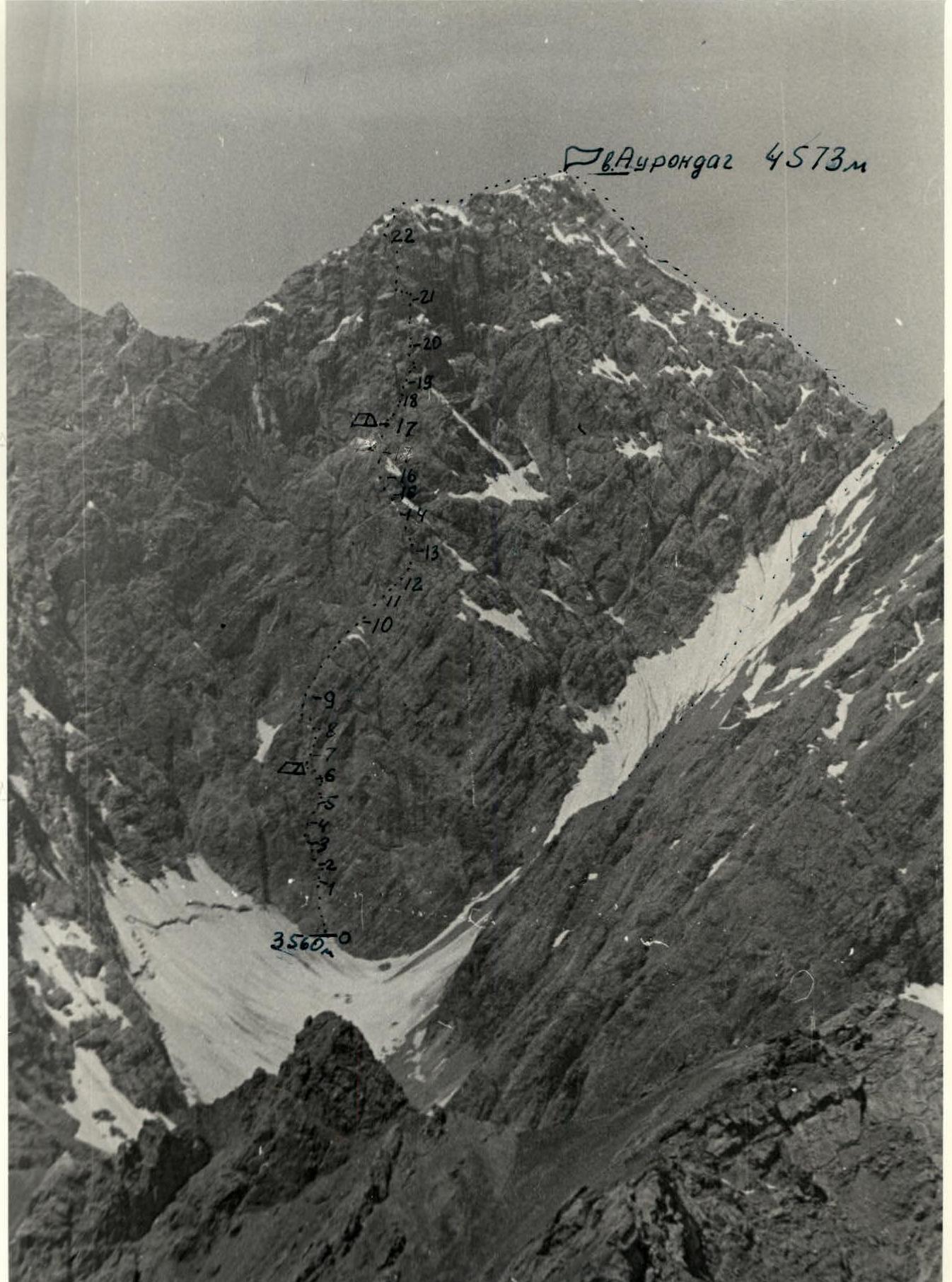
Route to the northeast face of Aurongdag peak.
Route Description
The route begins 60 m to the right of the black stream at the base of a wide inner corner. From the snow patch along gentle, smoothed rocks of the "sheep's forehead" type — 60 m, slope 70°. Climbing is of medium difficulty.
Then move up a steep vertical wall, 80°, for 20 m to a narrow vertical crevice. Climbing is difficult, rocks are smoothed. Up the narrow vertical crevice of the inner corner — 20 m. Slope 90°, rocks are smooth, practically without holds, climbing is very difficult. Then along the overhanging part of the inner corner with a slope of 95° – 10 m. Climbing is extremely difficult using ladders. Exit from the inner corner to the left onto a wall — 10 m, slope 85°, climbing is difficult, and then again into the inner corner. Along the inner corner to the overhanging cornice — 30 m, slope 85° along smooth walls. Climbing is very difficult. Few cracks for hammering pitons. Under the cornice, exit left onto a ledge. Along a cleft overhanging in the upper part up to 90°, exit to a wide ledge. Climbing is difficult, loose rocks. Here on the ledge is a control cairn.
From the platform, move up to the right along an oblique crevice and then up along steep, destroyed rocks to a short shoulder, steeply dropping to the left and down towards a grey-black couloir. Average slope 80°, length 40 m.
From the short shoulder, the route continues straight up under a sheer wall — 20 m, slope 85°, and then to the left to a large ice couloir. Climbing is difficult.
Then up to the right along a slab — 20 m to a ridge, slope 75°. Traverse left along a wall — 15 m, slope 80°, climbing is difficult.
Then up to the right along a slab — 50 m, slope 75°. Pass a short wall in its right part.
Then up to the left, crossing destroyed slabs — 40 m, slope 70°. Along an inclined inner corner, 75°, 60 m — exit to a ridge. Climbing is difficult. Along the ridge up to a shoulder — 60 m, slope 60°.
Along the shoulder, traverse to the right to a cleft with a plug — 40 m, which is the beginning of a steep counterfort. Bypass the chimney with a plug along the wall — 8 m, slope 85°, and exit straight under the wall — 15 m.
Along the ledge, move left and then straight up a steep (90°) wall — 7 m, exit to steep, inclined ledges to the ridge of the counterfort — 40 m.
Along the ridge of the counterfort — 40 m, slope 60° — exit under a wet wall, climbing is medium. Along the wet wall — 30 m, slope 75°, then along destroyed rocks — 60 m — exit under the base of the summit bastion. Here is a platform for an overnight stay.
From the overnight stay, the route passes along the summit bastion, initially straight up, then to the right under the wall. The wall — 10 m — is passed along a cleft.
Then the route goes in the direction of a large niche with an overhang — 40 m.
The overhanging wall in front of the niche is passed in its right part using ladders.
From the niche, traverse left — 40 m along a sheer wall to a not very wide flake. From here, straight up along the wall, crossing a stream of water, to a ledge — 40 m, slope 85°.
From the ledge — 40 m — exit to the summit ridge. Then along the summit ridge — exit to the summit.
From the summit, descent via the 3B route.
TABLE OF MAIN ROUTE CHARACTERISTICS

| Date | Section designation | Average slope /degrees/ | Length /m/ | Terrain characteristics | Difficulty | Condition | Weather conditions | Rock pitons | Ice pitons | Bolt pitons |
|---|---|---|---|---|---|---|---|---|---|---|
| 27.06 | R0–R1 | 70° | 60 m | rock ledge | IV | destroyed rocks | clear | 4 | ||
| R1–R2 | 80° | 20 m | wall | V | monolith | clear | 4 | |||
| R2–R3 | 90° | 20 m | chimney | VБ | smoothed rocks | clear | 5/II/ | |||
| R3–R4 | 95° | 10 m | chimney | VI | smooth rocks | clear | 5/IV/ | |||
| R4–R5 | 85° | 10 m | wall | V | monolith | clear | 3/I/ | |||
| R5–R6 | 85° | 30 m | cleft | V | monolith | clear | 4 | |||
| Departure at 11:00, stop for a bivouac at 18:00, overnight stay on a ledge, 7 climbing hours. | ||||||||||
| 28.06 | R6–R7 | 80° | 40 m | wall | V | loose rocks | clear | 5 | ||
| R7–R8 | 80° | 60 m | wall | V | monolith | clear | 10 | |||
| R8–R9 | 75° | 50 m | slab | V | monolith | clear | 5 | |||
| R9–R10 | 70° | 120 m | ridge | IV | destroyed rocks | clear | 8 | |||
| R10–R11 | 60° | 60 m | counterfort | IV | destroyed rocks | clear | 3 | |||
| R11–R12 | 30° | 40 m | ledge | III | destroyed rocks | clear | 2 | |||
| R12–R13 | 85° | 50 m | wall | V | monolith | clear | 6 | |||
| 29.06 | R13–R14 | 70° | 100 m | counterfort | IV | destroyed rocks | clear | 7 | ||
| R14–R15 | 75° | 30 m | wall | V | wet rocks | overcast | 4 | |||
| R15–R16 | 70° | 60 m | counterfort | IV | destroyed rocks | rain | 4 | |||
| Departure at 8:00, stop for a bivouac at 18:00, overnight stay on a ledge in a tent, 9 climbing hours. | ||||||||||
| R16–R18 | 80° | 40 m | wall | V | destroyed rocks | clear | 4 | |||
| R17–R18 | 80° | 70 m | wall | V | monolith | clear | 9 | |||
| R18–R19 | 95° | 10 m | inner corner | VI | monolith | clear | 5/III/ | |||
| R19–R20 | 90° | 40 m | wall | VI | monolith | clear | 8/V/ | |||
| R20–R21 | 85° | 40 m | wall | V | destroyed rocks | clear | 5 | |||
| R21–R22 | 70° | 35 m | ledges | IV | destroyed wet rocks | clear | 2 | |||
| R22–R23 | 20° | 120 m | ridge | II | wide ledge ridge | clear |