
Conclusions
- The ascent to the summit of Shlem via the western wall to the northern ridge is a rock climbing route of category 4B difficulty.
- The total height difference: glacier — Shlem summit — 450 m.
- The height of the western wall of the northern ridge — 200 m.
- The average steepness of the wall — 70°.
- The number of rock pitons hammered into the wall — 25.
- The group took 16 hours to reach the summit from the glacier.
- The most technically challenging sections:
- 150 m rock couloir.
- 80 m wall of the Shlem pinnacle.
- The route is objectively safe regarding rockfall.
Team leader  V. Andreev.
Participants 
- V. Stepchenkov.
- A. Kurshin.
- R. Nikanorova.
1963
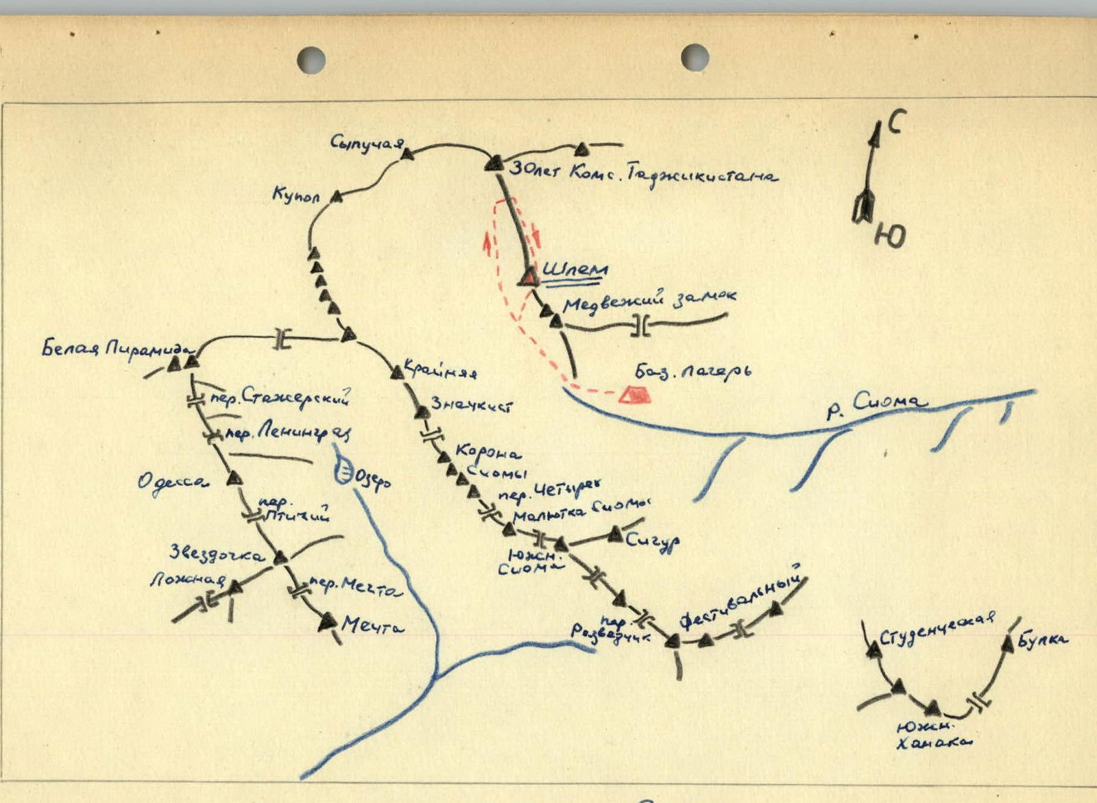
Map of Sioma region
Description of the ascent
On July 23, 1963, a group of climbers from MOS DSO "Trud" consisting of:
- team leader Andreev V. — 1st sports category
- participants: Stepchenkov V. — 1st sports category, Kurshin A. — 1st sports category, Nikanorova R. — 2nd sports category, medic
left the base camp under Medvezhiy Zamok at 5:00 and headed towards Shlem summit. The goal was to find a new ascent route to Shlem from the west. The group was fully equipped with necessary gear: three duralumin 3-step ladders, titanium and a large set of rock pitons, carabiners, a primus stove, and a complete set of pulley equipment. For a detailed visual inspection of the new ascent route, the group had a spyglass.
Initially, the trail follows the direction towards Korona Sima summit but soon turns right and proceeds along the lateral moraine, adhering to the slopes of Medvezhiy Zamok. After 2.5 hours, they reached a vast snow cirque west of Medvezhiy Zamok and Shlem.
After carefully examining the descent route from Shlem, they continued along the glacier alongside the western wall of Shlem. The western wall of Shlem is a 500 m sheer drop with overhanging sections. Many rocks lay at the base of the wall, indicating rockfall. They proceeded further along the ridge extending north towards 30 let Komsomola Tadzhikistana summit. It was more of a continuous 300–350 m wall of smoothened slabs rather than a ridge. Only in one spot did they find a section of the wall without rocks at its base.
They were now closer to 30 let Komsomola Tadzhikistana than to Shlem, but the route seemed logical and interesting, so they decided to examine it closely.
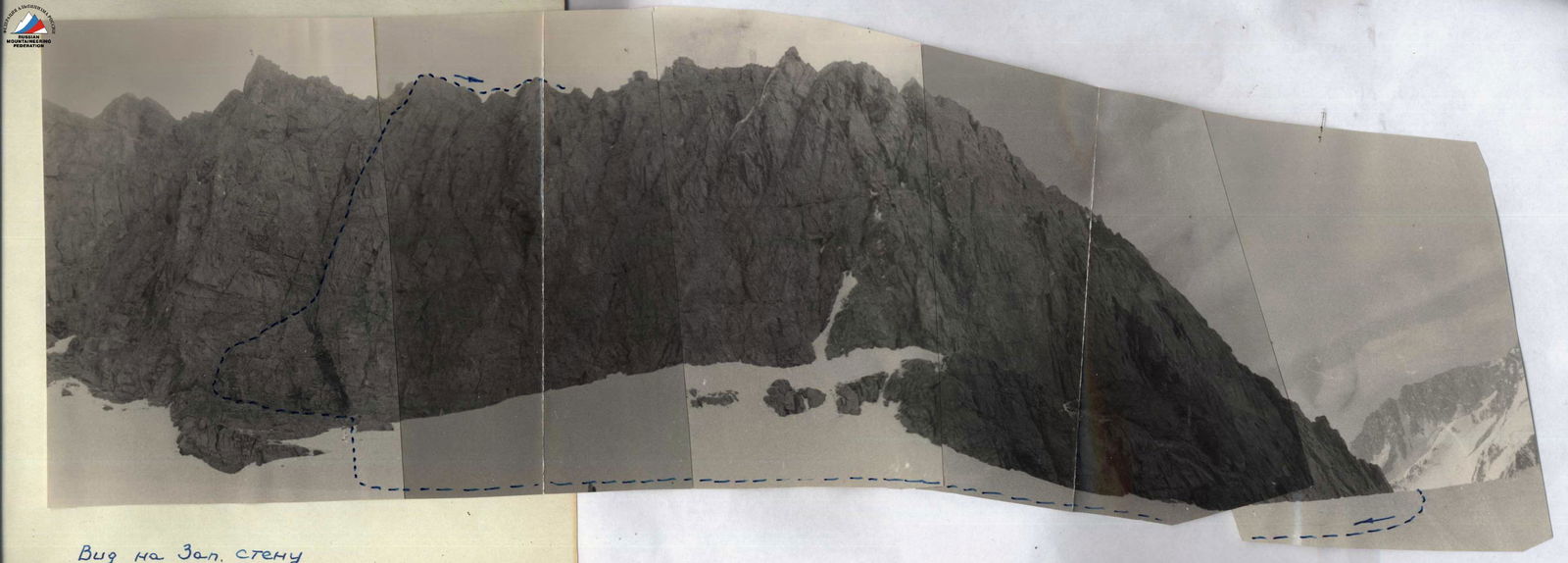 View of the Western wall
 Route via the western wall of the northern ridge to Shlem.
The route began near the base of a broad snow couloir steeply ascending from right to left towards the western shoulder of 30 let Komsomola Tadzhikistana. After a thorough examination, they decided to ascend via this route. Almost the entire path to the ridge involved traversing a steep and narrow rock couloir ascending from left to right. The couloir was blocked at the top by two large boulders visible from below.
After making sketches of the route and taking several photos, they approached the wall in two rope teams:
- Andreev–Nikanorova
- Stepchenkov–Kurshin.
The entry from the snowfield onto the rocks was of moderate difficulty. They traversed left along ledges for one rope length to a нависающему камню (overhanging rock). The ascent onto the rock was made using a ladder or with the help of a partner's shoulders. The top of the rock was a 5 m slab with a 45° incline. They then continued on easier rocks to a sheer 200 m wall. Along a narrow ledge, they traversed 40 m of the wall to the right to a narrow rock couloir. In the middle section, the ledge was intersected by a steep inclined slab, which they overcame using a pendulum motion after hammering a piton above. Six pitons were used in this section. The couloir walls were smoothened slabs akin to "sheep's foreheads" with a 70° incline. The left side of the couloir was sheer. They ascended two rope lengths along the right side of the couloir to a bottleneck with a narrow slit on the left containing accretion ice. The bottleneck was 3 m high with completely smooth walls. Upon exiting the bottleneck, there were several ledges where both rope teams could gather. Further up, a 40 m slab of the "sheep's foreheads" type awaited. There were almost no cracks; they ascended using friction. The incline was 75°. The first climber wore gym shoes, and the rest followed on the fixed rope. At the exit, there was a good ledge where they built a control cairn and left a note in a can.
To the left and upwards for 15 m, another slab with a 60° incline led to a small clearing. From there, they ascended directly upwards, bypassing a visible bottleneck to the right, and reached a fairly wide 2–3 m ledge with large rocks after 20 m. They gathered and rested here. Along the ledge, they approached the last 15 m slab in this couloir. The slab was steep at 70° and smooth but had cracks for pitons. After the slab, they navigated between large rocks and exited onto the ridge after two rope lengths. Descending along the ridge for five rope lengths, they organized an overnight stay in a depression before the Shlem pinnacle. The western side dropped away in sheer walls, while the eastern side had a snowy slope and an icefall.
On July 28 at 7:00 AM, the same rope teams ascended two snow pitches of 40°–45° and then continued on rocks of moderate difficulty to a large inclined ledge to the right with two enormous faceted boulders. It took eight rope lengths from the depression to reach this point. From here, the northern edge rose steeply, transitioning into walls. The wall was 80 m high with a 70°–80° incline, and some sections even overhung to the west. Chimney blocks were bypassed on the right via smooth slabs. Further, one rope length required direct ascent along a vaguely defined edge. The rocks were of moderate difficulty. Protection was via pitons and rock protrusions. The ledge that the first rope length led to was still one rope length away from exiting the wall. It involved very strenuous climbing without backpacks. Initially, they ascended left and upwards for 8 m along the wall, then climbed 5 m up a narrow crevice, followed by a pendulum swing across a vertical fissure to a small ledge, and from there ascended a 70° slab to a small ledge with a separate rock. This ledge was at the base of a 10 m internal corner with completely smooth walls. From below, this dark corner with a snow patch stuck to the right wall was visible. They ascended via this snow-ice patch, cutting steps.
The snow patch ended 2 m below the upper edge of the wall. Pulling themselves up with their hands, they climbed onto a sharp ridge crest, from which they moved right along a narrow crevice for 15 m, and then ascended a slab to easier rocks. Another rope length of simultaneous movement brought them to Shlem summit. They descended from the summit southwards towards Medvezhiy Zamok via a category 4A route and returned to the base camp by 18:00.
Comments
Sign in to leave a comment