Ascent Passport
-
ASCENT CLASS: technical
-
ASCENT AREA, RANGE: Pamir-Alay, Gissar Range
-
PEAK, ITS HEIGHT, ASCENT ROUTE: Khodzha Lokan (4767 m) via the Western part of the South face
-
DIFFICULTY CATEGORY: approximately VI category of difficulty
-
ROUTE CHARACTERISTICS:
- ELEVATION GAIN: 1170 m
- LENGTH OF COMPLEX SECTIONS:
- III — 50 m
- IV — 250 m
- V — 555 m
- VI — 390 m
- AVERAGE STEEPNESS: 82°
-
PITONS DRIVEN:
- ROCK: 266 (for belay), 25 (for creating artificial holds)
- ICE: –
- BOLTS: 1
-
NUMBER OF CLIMBING HOURS: 41
-
NUMBER OF OVERNIGHTS AND THEIR CHARACTERISTICS: three, satisfactory, one semi-reclining, two sitting
-
SURNAME, NAME, PATRONYMIC OF THE LEADER (SIGNATURE), PARTICIPANTS AND THEIR QUALIFICATION:
- Osis Yuris Rudolfovich, CMS, leader
- Kulis Peteris Borisovich, CMS, deputy leader
- Kyuzan Mark Petrovich, CMS, participant
- Osipov Vladimir Tukhtarovich, CMS, participant
- Klestov Valery Iosifovich, CMS, participant
- Orlov Vladimir Yakovlevich, CMS, participant
- Nazarenko Viktor Grigorievich, CMS, participant
- Altshuler Leonid Borisovich, CMS, participant
-
TEAM NAME AND COACH (SIGNATURE):
- Team of a/l "VARZOB", coach: Kapitanov O. V.
-
DATE OF DEPARTURE ON THE ROUTE AND RETURN:
- Departure — August 13, 1982, return — August 16, 1982
- first ascent route — approx. 6th category of difficulty, 1982
- Grushevsky's route on the S face — 5B category of difficulty, 1978
- Igolkin's route on the pillar — 5B category of difficulty, 1981
- route on the SE edge (classic) — 5B category of difficulty, 1960
Map — Scheme of the Ascent Area
Ascending
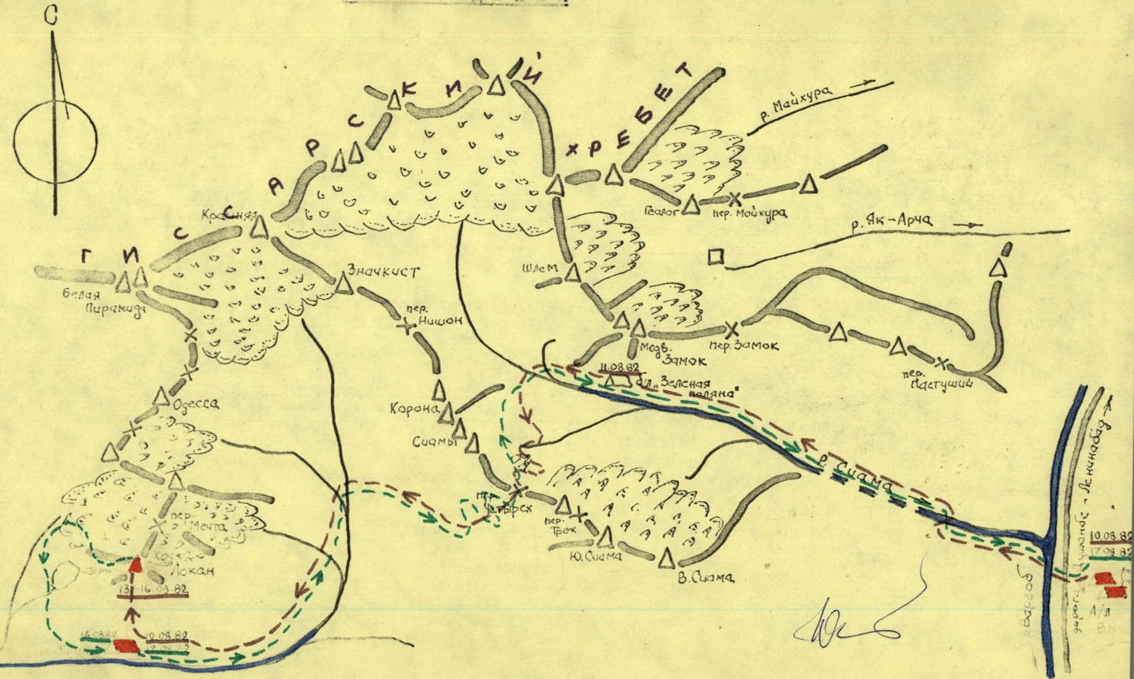
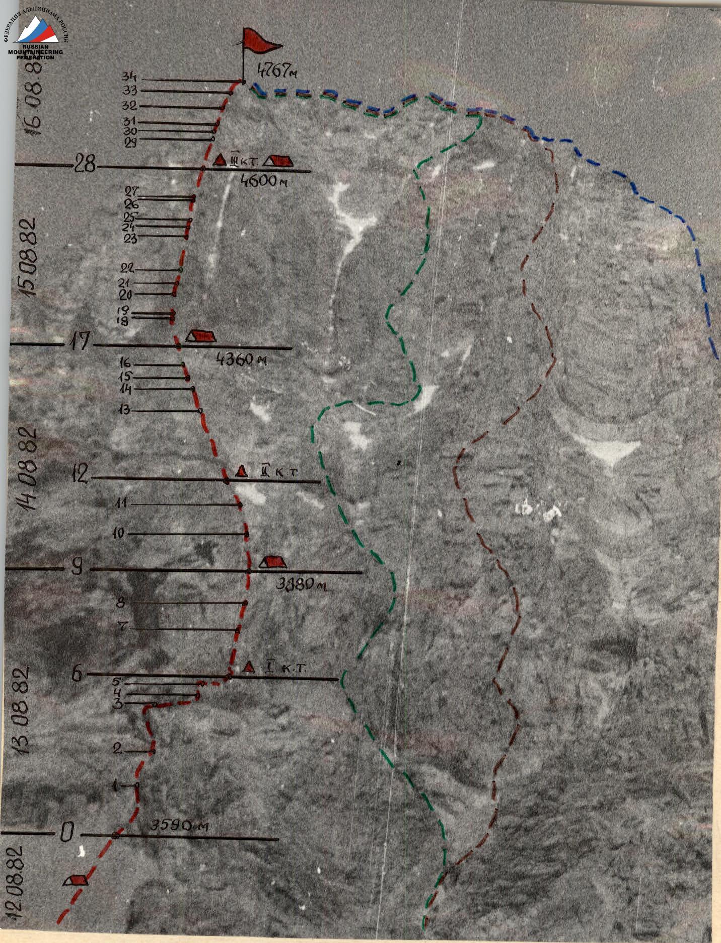
Table of Main Characteristics of the Ascent Route
on peak Khodzha Lokan via the Western part of the South face (4767 m) — first ascent.
| Date | Designation | Average Steepness | Length, m | Terrain Characteristics | Difficulty | Condition | Weather Conditions | Rock Pitons | Ice Chocks | Bolt Pitons | Ice Pitons |
|---|---|---|---|---|---|---|---|---|---|---|---|
| 13.08.1982 | R0–R1 | 90 | 40 | internal angle | V | monolith | good, sunny | 4 | 3 | – | – |
| R1–R2 | 90 | 60 | wall with overhangs | V | monolith | – " – | 6 | 5(1) | – | – | |
| R2–R3 | 85 | 50 | oblique shelf under a cornice | VI | monolith | – " – | 5 | 4(2) | – | – | |
| R3–R4 | 90 | 20 | wall with an internal angle | VI | monolith | – " – | 3 | 4 | – | – | |
| R4–R5 | 85 | 30 | oblique shelf under a cornice | VI | monolith | – " – | 4(1) | 4 | – | – | |
| R5–R6 | 95 | 10 | sheer chimney | VI | monolith | – " – | 2 | 4(1) | – | – | |
| R6–R7 | 80 | 60 | wall with small ledges | VI | monolith | – " – | 8 | 5(1) | – | – | |
| R7–R8 | 80 | 20 | chimney | V | monolith with live rocks | – " – | 2 | 4 | – | – | |
| R8–R9 | 80 | 15 | internal angle | V | broken rock | – " – | 1 | 5 | – | – | |
| Departure on the route — 8:30; stop for bivouac — 20:30; climbing hours — 12 hours; bivouac conditions satisfactory, semi-reclining, no water. | |||||||||||
| 14.08.1982 | R9–R10 | 75 | 60 | narrow, sloping shelf | IV | broken rock | good, sunny | 3, ledges | 3 | – | – |
| R10–R11 | 80 | 60 | corrie throat | V | monolith, few cracks | – " – | 4 | 6 | – | – | |
| R11–R12 | 70 | 50 | walls with shelves | III | broken rocks | – " – | ledges | – | – | – | |
| R12–R13 | 70 | 150 | ridge | IV | walls, broken rock | – " – | ledges | 5 | – | – | |
| R13–R14 | 80 | 80 | wall with smoothed slabs | V | monolith, few cracks | – " – | 4 | 6 | – | – | |
| R14–R15 | 90 | 20 | chimney | V | monolith | – " – | 2 | 3 | – | – | |
| R15–R16 | 80 | 20 | sloping slab | V | monolith | – " – | 3 | 2 | – | – | |
| R16–R17 | 90 | 40 | internal angle | V | monolith | – " – | 5 | 2 | – | – | |
| Departure on the route — 9:00; stop for bivouac — 19:00; climbing hours — 10 hours; bivouac conditions satisfactory, sitting, water/snow, ice available. | |||||||||||
| 15.08.1982 | R17–R18 | 90 | 25 | slab-like wall | VI | monolith | satisfactory, fog | 5(1) | 4(1) | – | – |
| R18–R19 | 95 | 5 | cornice | VI | monolith | – " – | 2(1) | 2(1) | – | – | |
| R19–R20 | 90 | 30 | slab-like wall | VI | monolith | – " – | 4 | 7(1) | – | – | |
| R20–R21 | 100 | 20 | cornice with a chimney | VI | monolith | – " – | 5(1) | 4(1) | – | – | |
| R21–R22 | 90 | 25 | internal angle | V | monolith | sunny | 5 | 3 | – | – | |
| R22–R23 | 95 | 35 | sheer internal angle | VI | monolith | – " – | 8(2) | 6(1) | – | – | |
| R23–R24 | 90 | 15 | wall | VI | monolith | – " – | 3 | 5 | – | – | |
| R24–R25 | 95 | 10 | cornice | VI | monolith | – " – | 3 | 6(2) | 1 | – | |
| R25–R26 | 90 | 30 | wall with cornices | VI | monolith | – " – | 6 | 9(1) | – | – | |
| R26–R27 | 95 | 5 | cornice | VI | monolith | – " – | 3 | 4(2) | – | – | |
| R27–R28 | 85 | 40 | wall with overhangs | V | monolith | – " – | 3 | 4 | – | – | |
| Departure on the route — 9:00; stop for bivouac — 20:00; climbing hours — 11 hours; bivouac conditions satisfactory, sitting (for 4 people), snow and ice available. | |||||||||||
| 16.08.1982 | R28–R29 | 95 | 20 | wall with cornices | VI | monolith | fog | 10 | 3(2) | – | – |
| R29–R30 | 90 | 15 | internal angle | V | monolith | – " – | 2 | 3 | – | – | |
| R30–R31 | 95 | 25 | wall with a cornice | VI | monolith | – " – | 5 | 10(2) | – | – | |
| R31–R32 | 75 | 60 | walls, internal angles | V | monolith | cloudy | 4, ledges | – | – | – | |
| R32–R33 | 80 | 60 | ridge with walls | V | monolith, broken rock | – " – | ledges | 7 | – | – | |
| R33–R34 | 70 | 40 | ridge | IV | broken rock | sunny | ledges | – | – | – |
Brief Description of the Table of Main Characteristics of the First Ascent Route
August 12, 1982. Base camp near the Kadam-Tash River under the south face of peak Khodzha Lokan. The team observed the route throughout the day. Reviewing the most potentially complex sections of the route using binoculars. Reviewing and selecting equipment according to the observations. The team departed under the start of the route at 17:00 (2 hours 30 minutes).
August 13, 1982. Sections R0–R2 are traversed with piton belay. The rocks are clean, not prone to rockfall, and the belay locations are inconvenient.
We approach the first key of the route. Along a complex, smoothed shelf, we traverse rightward under a huge, overhanging cornice (R2–R3). We overcome the wall along an internal angle (R3–R4), then continue along the oblique shelf (R4–R5) under the cornice and reach the start of a sheer chimney (R5–R6). Very complex climbing (R2–R6), heavily smoothed. Overcome with piton belay using artificial holds. Through the sheer chimney (R5–R6), with very complex climbing, we emerge above the cornice at the base of a large vertical wall. There is a tiny platform above a characteristic break (space for two people only). The first control cairn is built here. The wall (R6–R7) is 60 m long and is traversed with very complex climbing, mostly on of friction, with very few cracks and minimal holds.
Further, from the shelf (on two people), first along a chimney (R7–R8), then transitioning to an internal angle (R8–R9) with piton belay, we emerge onto stepped shelves, where we planned to bivouac. The bivouac is inconvenient, semi-reclining — we settle on two shelves, and there is no water.
August 14, 1982. From the bivouac, along a narrow, inclined shelf to the right, we make our way to the corrie throat (R9–R10). Along the left side of the throat (R10–R11), without descending into the corrie (due to rockfall danger!), we emerge along simple rocks (R11–R12) onto the left side of the corrie. Here, there are convenient bivouac locations, but there is no water in the second half of summer; water is available in the central part of the corrie, but rockfall danger limits access to it. The second control cairn is built here.
From the control cairn, along a clearly defined, destroyed ridge of the spur (R12–R13) with increasing steepness, we approach the base of the spur, above which the summit bastion rises sheer. Belay is organized using ledges and chocks.
The ridge ends at the base of a wall composed of smoothed slabs (R13–R14). Climbing is complex. The wall leads to the base of a huge gendarme with sheer walls. We bypass the gendarme on the right along a sheer chimney (R14–R15), then along an inclined slab (R15–R16) and a sheer internal angle (R16–R17). We use piton belay. We emerge at the sheer face of the summit bastion.
Further, as anticipated, a very complex task lies ahead. There are no paths to bypass the bastion. To the right and left — sheers with cornices; the summit couloirs on both sides are clearly prone to rockfall.
The shelves for bivouac are tiny; again, we have to set up sitting, separate (for four people) bivouacs. To fetch snow and ice, we have to descend from the shelves with belay to the crevices in the sides.
August 15, 1982. The upcoming sections of the bastion prove to be more complex than anticipated, as no bypasses for the most difficult sections are found. Weather conditions are satisfactory, foggy, but visibility in the clearances is up to 100 m.
Further path along the ridge part of the bastion. Very complex climbing along a slab-like wall (R17–R18) with piton belay, mostly on friction. The wall is cut by a convexity of the rock, forming a sheer cornice (R18–R19), which we traverse on ladders, with rucksacks suspended "American-style". Further, it seems, the continuation of the wall section to the cornice (R19–R20), extremely difficult climbing. The wall is crowned with an overhanging cornice, the middle part of which is cut by a sheer chimney (R20–R21); ladders, pitons, and chocks are used. Very complex rope work. Belay is on a harness.
The chimney above the cornice transitions into a sheer internal angle (R21–R22). The sun appears. The internal angle in the upper part transitions into an overhang (R22–R23), which we traverse on ladders with piton belay. A section of a sheer wall (R23–R24) with complex climbing leads under a 10-meter cornice (R24–R25) with a small number of good cracks, which we traverse on ladders with piton belay. For safety, a bolt piton is driven here.
The last section (R25–R27) is characterized by a wall with cornice outcrops, the last of which (R26–R27) is traversed on ladders with piton belay. Very complex.
The wall of the bastion becomes less steep. Section (R27–R28) is traversed with piton belay. Approximately 1.5 very complex passes are still visible. On tiny shelves, we set up sitting bivouacs for 8 people; for a group of 4, lying-down bivouacs are possible. There is snow and ice in the cracks of the sides. The third control cairn is built here.
August 16, 1982. A wall with cornices (R28–R29), very complex climbing, traversed with piton belay. The wall becomes less steep (R29–R30) and is traversed along a vertical internal angle with piton belay. The last sheer ascent of the bastion (R30–R31) is traversed using ladders and numerous chocks. Only here does the second key of the route end, the basis of which is approximately 200 m of very complex climbing (sheer walls, cornices, etc.). Psychologically very complex sections, but traversed without pulling up rucksacks.
Further, the bastion becomes less steep, transitioning into a destroyed ridge (R31–R33) with episodic wall sections. A steep ridge section (R33–R34) leads us directly to the summit. ![img-2.jpeg]{"width":1654,"height":1915,"format":"Jpeg","uri":"https://summitx.info/media/1/5FcYvyjyfE6WNfGPXbKBDvnLqGNrKGua/img-2.jpeg","id":64790298}↗)
Section R2–R3
Khodzha Lokan
![img-3.jpeg]{"width":2187,"height":2158,"format":"Jpeg","uri":"https://summitx.info/media/1/xe6j2TR6WohuN1EWDh6gaZTr1sNSKlMg/img-3.jpeg","id":64790299}↗) ![img-4.jpeg]{"width":1597,"height":1896,"format":"Jpeg","uri":"https://summitx.info/media/1/RySGyjOsJafyG7QVrWHR5zJhoUzUkzky/img-4.jpeg","id":64790300}↗)