Ascent Passport
- Ascent class — rock climbing.
- Ascent area — Pamir-Alay, Gissar Ridge.
- Peak, its height, ascent route — p. Ular, 4000 m, via the southern counterfort. S. wall.
- Estimated difficulty category — 3B.
- Route characteristics: a) Height difference — 250 m. b) Length of sections with 4A difficulty category – 50 m, 3rd category – 200 m. c) Average steepness — 60°.
- Pitons driven: a) Rock — 15 b) Ice — none c) Bolt — none
- Number of travel hours — 5–7 hours.
- Number of overnight stays and their characteristics — none.
- Surname, name, patronymic of participants, their qualification:
- Mikaelyan Arutyun Mikaelovich — Candidate for Master of Sports.
- Oganesov Artem Oganesovich — Candidate for Master of Sports.
- Coach — Sogrina Emma Grigoryevna, senior instructor, Master of Sports.
- Date of departure on the route and return:
August 2, 1979 at 7:00 AM departure from the "Green Glade" bivouac. August 2, 1979 at 4:00 PM return to the bivouac.
From the "Green Glade" bivouac in the Igizakov gorge, go upstream along the stream flowing from the left circus to the old moraine of the Ular glacier. From the moraine, ascend the snowfield to the Ular glacier plateau, from which exit to the Vorobьиный Pass. Descend from the Vorobьиный Pass towards the Khodzha-Obi-Garm gorge – 70 m. Then traverse left 150–200 m, crossing small ridges, approach the 30-meter couloir, which leads to a "window" in the ridge. The window is formed by a large horizontally lying stone. To the right of the window is a rock tooth. At the beginning of the season, there is snow in the couloir, and the window opens when approaching it. On the platform above the window — a signal cairn — the start of the route. The signal cairn is clearly visible from afar.
The approach takes 2.5 hours.
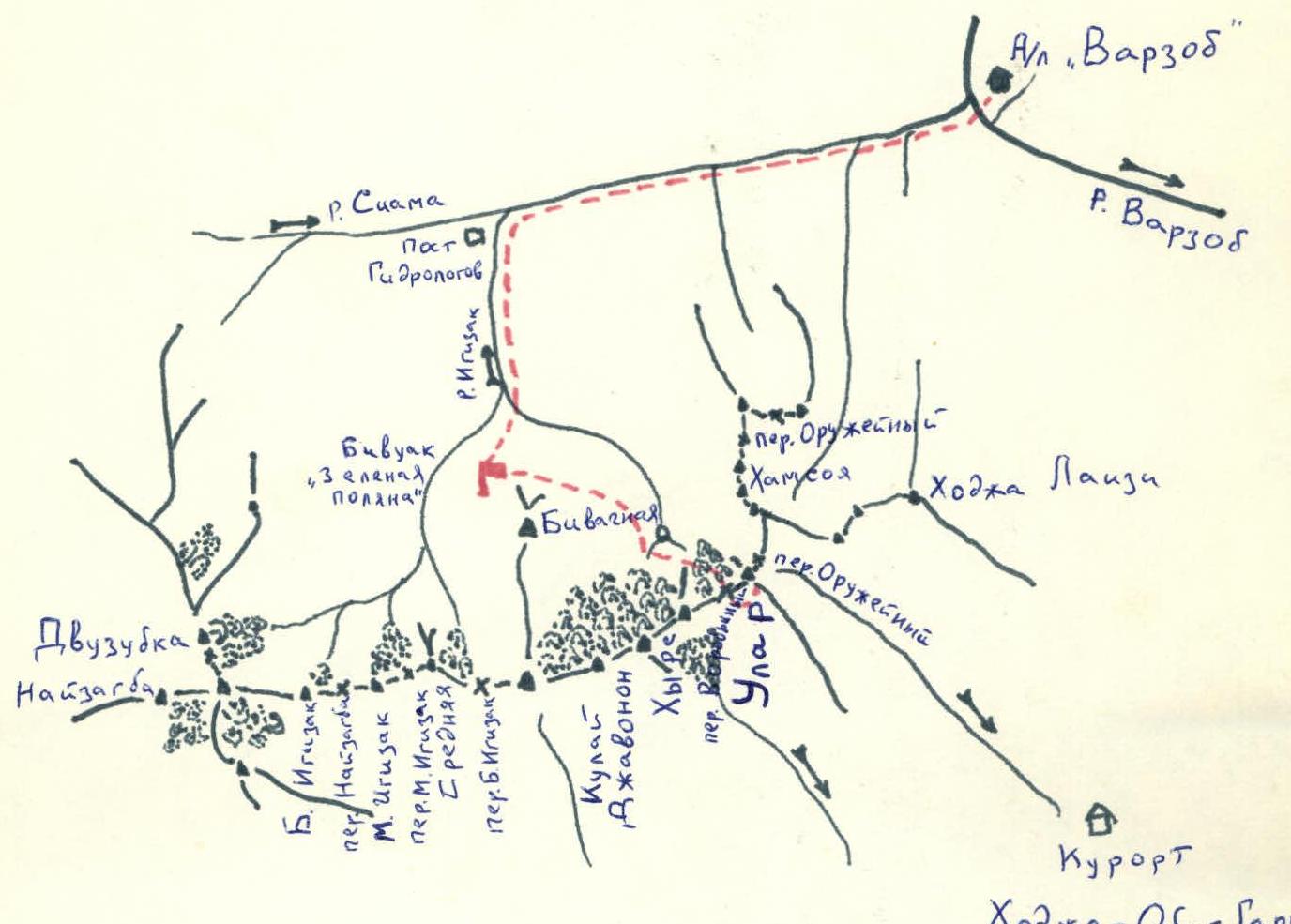
Igizakov area diagram.
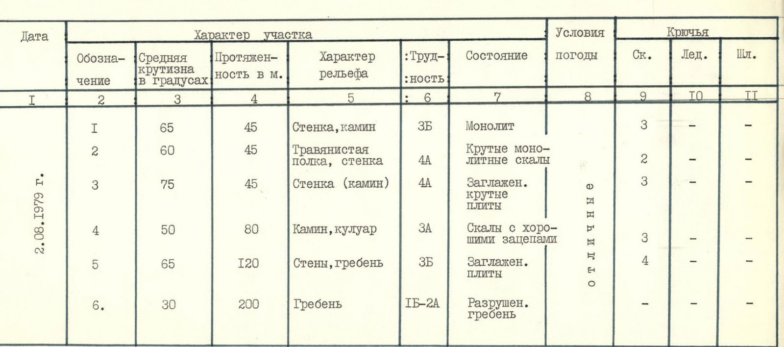
Table.
| Date | Designation | Average steepness in degrees | Length in m | Relief character | Difficulty | Condition | Weather conditions | Rock Pitons | Ice Pitons | Bolt Pitons |
|---|---|---|---|---|---|---|---|---|---|---|
| August 2, 1979 | 1 | 65 | 45 | Wall, chimney | 3B | Monolith | Excellent | 3 | - | - |
| 2 | 60 | 45 | Grassy ledge, wall | 4A | Steep monolithic rocks | Excellent | 2 | - | - | |
| 3 | 75 | 45 | Wall (chimney) | 4A | Smoothed steep slabs | Excellent | 3 | - | - | |
| 4 | 50 | 80 | Chimney, couloir | 3A | Rocks with good holds | Excellent | 3 | - | - | |
| 5 | 65 | 120 | Walls, ridge | 3B | Smoothed slabs | Excellent | 4 | - | - | |
| 6 | 30 | 200 | Ridge | 1B–2A | Destroyed ridge | Excellent | - | - | - |
Explanation of the table.
Section 1.
From the platform above the "window," a 15-meter wall with good holds leads to a ledge. Then move along a 30-meter chimney:
- After 8 meters along the chimney — a plug, which is passed on the left;
- The chimney leads to a grassy ledge. Climbing is difficult, piton belay.
Section 2.
Along grassy ledges, 15 meters approach a diagonal crack. 30 meters of steep rocks lead to a platform. Piton belay.
Section 3.
Up and to the right along gentle rocks, 15 meters approach a wall consisting of steep smooth slabs. 30 meters of difficult climbing, piton belay, few cracks for pitons. At the top, a platform, a control cairn (a can hanging on a piton above the platform). A second variant of ascent to the control cairn is possible:
- From the right edge of the platform, up a wide steep 20-meter chimney.
- Then up and left to a round gendarme.
- Followed by a descent from it to the platform to the control cairn.
Section 4.
Along the ridge, 10 meters approach two parallel chimneys, each 60 meters long. The left chimney is steep with a plug in the middle. The path goes through the right chimney. Then:
- Across a sheer smooth 2-meter wall with a rappel, transfer to the right chimney.
- Then up the chimney 30 meters along rocks of average difficulty.
- The chimney turns into a couloir, which after 40 meters leads to a platform under a gendarme on the ridge.
Section 5.
The gendarme is flanked on both sides by walls. The gendarme is passed head-on. 60 meters of smooth slabs lead to the top of the gendarme. Steep, piton belay. Descent from the gendarme along simple rocks. Then along the ridge, approach under an 8-meter wall resembling a ram's forehead, which from afar seems impassable. Overcoming this wall head-on, moving slightly from right to left, exit onto a simple ridge.
Section 6.
Then along average rocks, along the destroyed ridge, gaining and losing height, move in the direction of the summit. Overcoming the summit ascent, exit to the summit. At the beginning of the season, there is snow on the ridge, and cornices are possible! Descent from the summit along a couloir to the glacier — 1B category.
The ascent takes 9–11 hours.
The route is rated 3B category.
Recommended for sports groups and well-trained rock climbing training groups.

Section 1. Start of the route.
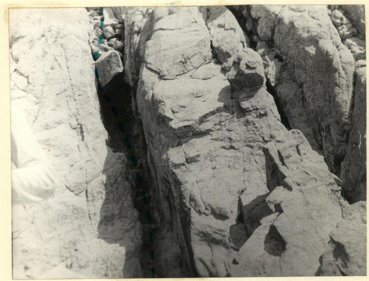
Section 1. Chimney with a plug.

Section 3. First variant of ascent to the control cairn. Second variant.