- Climbing category — winter ascent
- Climbing area — Gissar Range, Sur-Kuh spur.
- Peak, its height, and ascent route — Surkh-Nu peak (2980 m) via the right counterfort, left part of the southeast wall.
- Estimated difficulty category — 3A.
- Route characteristics: height difference — 880 m, average steepness: wall section — 56°, ridge — 30°–35°, section lengths: 1st difficulty category — 500 m, 2nd difficulty category — 330 m, 3rd difficulty category — 180 m, 4th difficulty category — 70 m, 5th difficulty category — 0 m, 6th difficulty category — 0 m.
- Pitons used: rock 10 (0), ice 0 (0), bolted 0 (0), chocks 6 (0).
- Number of climbing hours — 6 (not including approach to the wall 4 hours and descent from the summit 2 hours).
- Number of nights, their characteristics — one in the base camp.
- Surname, name, patronymic of the leader and participants, their sports qualification:
- Kashina Olga Gennadievna CMS
- Leonov Konstantin Nikolaevich CMS
- Yakhontova Elena Borisovna 1st sports category
- Porotnikov Vladimir Leonidovich 1st sports category
- Coach: Leonov Konstantin Nikolaevich CMS
- Date of departure on the route and return:
February 16, 1985 — arrival at the base camp
February 17, 1985 — summit, descent to the base camp
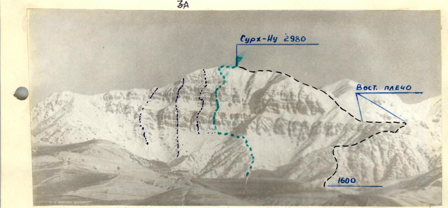
Panorama of Surkh-Nu peak, Southeast wall. "Zenit" camera with "Helios-44" lens, shooting point #1, time — 9:30.
- – Recommended route, 3A difficulty category.
- – E. Lorenz route, 1B difficulty category. — descent path.
| Section # | Chocks | Bolted pitons | Ice pitons | Climbing hours | Section length, m | Steepness, ° | Difficulty category |
|---|---|---|---|---|---|---|---|
| R1 | – | – | – | 1 | 500 | 30° | 1 |
| R2 | 2 | – | – | 1 | 100 | 50° | 3 |
| R3 | 1 | 2 | – | 1 | 80 | 50° | 2 |
| R4 | 4 | 2 | – | 1 | 80 | 60° | 3 |
| R5 | 2 | 2 | – | 0.5 | 70 | 60° | 4 |
| R6 | – | – | – | 0.5 | 150 | 45° | 2 |
| R7 | 1 | – | – | 1 | 100 | 45° | 2 |
Route description by sections
The route follows the right counterfort of the left part of the SE wall of Surkh-Nu peak. Before reaching the rock massif, traverse left to the second couloir, to the beginning of the 1st rock belt. Section R0–R1. Ascend through simple rocks to a sloping snow shelf and further to the snow belt. Before reaching the snow belt — a control cairn. Section R1–R2. Along the snow belt, leaving the rock bastion to the right, approach the beginning of the 2nd rock belt. Section R2–R3. Ascend a small wall, steepness 60°, to the wall of the couloir, its left side. Section R3–R4. Continue via an internal corner, steepness 60° (caution: loose rocks!). Section R4–R5. Move right along the ridge. Through small walls alternating with snow shelves, approach the beginning of a short snow ridge. Section R5–R6. Along the ridge to a small wall, pass the wall, and reach a small snow shelf. Across the shelf left to a large sloping slab (caution at the end of the slab — rocks!). Section R6–R7. Having passed the slab, reach the pre-summit ridge and along it to the summit (caution on the ridge — cornices!).
Descent from the summit via the SW ridge, 1B difficulty category. The ascent takes 12–13 hours (including approach to the wall and descent from the summit to the base camp).