
-
Climbing category — winter ascents.
-
Climbing area — Gissar Range, Surkh-Kuh spur.
-
Peak, its height, and ascent route — Surkh-Nu peak (2980 m) via the left counterfort, left part of the southeast wall.
-
Estimated difficulty category — 3B.
-
Route characteristics: height difference — 880 m, average steepness of the wall section — 56°, ridge — 30–35°; section lengths: R1 — 500 m, R2 — 240 m, R3 — 260 m, R4 — 85 m, R5 — 15 m, R6 — .
-
Pitons hammered:
for belaying for creating anchor points rock 18 pcs. ice — bolts — protection 21 pcs.
- Total climbing hours — 6 hours (excluding 4 hours approach to the wall and 2 hours descent from the summit).
- Number of bivouacs, their characteristics — one in the base camp.
- Surname, name, patronymic of the leader and participants, their sports qualification:
- Shakirzhanov Vitaly Nikolaevich CMS
- Prilepa Evgeny Alexandrovich CMS
- Coach: Leonov K.N. CMS.
- Date of departure and return:
February 9, 1985 — arrival at base camp;
February 10, 1985 — summit;
February 10, 1985 — descent to base camp.
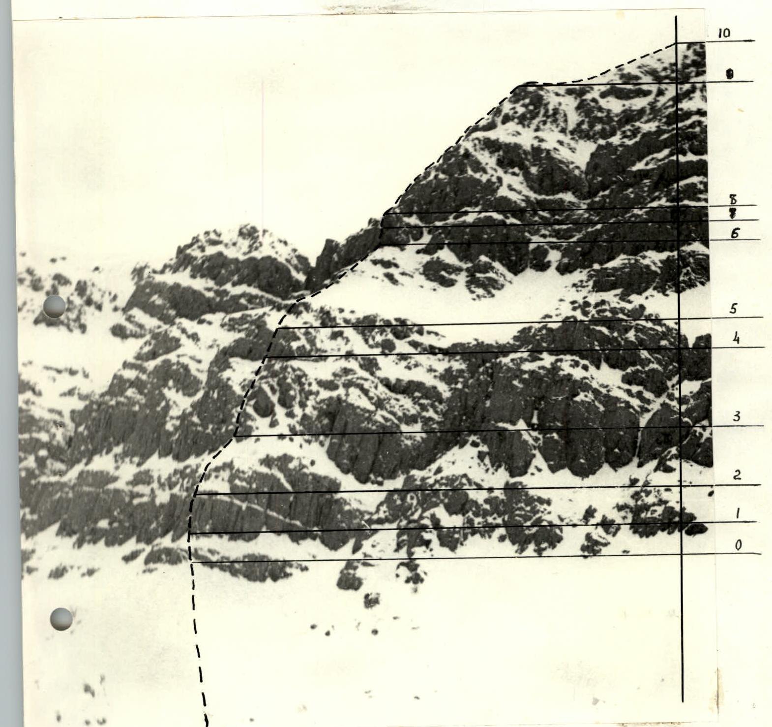
 “Southeast wall, Surkh-Nu peak”. “Zenit” camera with “Helios-44” lens, shooting point #1, time — 9:30.
 “Surkh-Nu peak. Profile from the right”. “Smena” camera, shooting point #2, time — 10:40.
Approach Description
The ascent to Surkh-Nu peak is made from the Surkh-Nu river cirque. The approach from Lyuchob village along the old dirt road takes 1 hour 30 minutes to the mouth of the Surkh-Nu river. 200 meters before the Surkh-Nu river, there is a hut on the slope to the left where the base camp can be set up.
From the base camp, follow along the bank of the Surkh-Nu river, crossing several times over large stones from one bank to the other. Then ascend the snowy slope to the base of the wall.
The approach to the route from the hut takes 4–5 hours.
Area Map

Table of Main Route Characteristics
| Rock Pitons | Protection | Bolt Pitons | Ice Pitons | Climbing Hours | Route Diagram. Scale 1:53 000 | Length, m | Steepness, ° | Difficulty Category |
|---|---|---|---|---|---|---|---|---|
| – | – | – | – | 1 | Pre-summit snow ridge, built without scale. | 500 | 35 | 1 |
| 3 | 4 | – | – | 5 |  | 140 | 55 | 3 |
| 4 | 2 | – | – | – | 2 — rock belt. | 75 | 75 | 5 |
| 2 | 4 | – | – | – | 15 | 70 | 4 | |
| – | – | – | – | – | Large snow shelf. | 130 | 45 | 2 |
| 2 | 3 | – | – | – | Rocky bastion. | 30 | 70 | 4 |
| 2 | 3 | – | – | – | 120 | 60 | 3 | |
| 1 | 1 | – | – | – | 80 | 50 | 2 | |
| 3 | 4 | – | – | – | 2 — rock belt. | 40 | 70 | 4 |
| 1 | – | – | – | – | 30 | 50 | 2 |
Route Description
The route passes through the left counterfort of the left part of the southeast wall. Section R0–R1.
- Approach the I rock belt via the snowy slope.
- A short 10 m wall (50°) is overcome directly upwards.
- Then follow a small snow shelf to the base of the I rock belt. Steepness 45°. Section R1–R2.
- Ascend a steep wall (65°) to an internal corner, straight up the corner for 25 m.
- Steepness 70°.
- Holds and cracks are filled with snow and ice. Control cairn.
Section R2–R3. 80 m along a snow shelf (50°). The shelf has small rocky islands covered with ice. Section R3–R4.
- Ascend 120 m through a series of short walls, chimneys, and snow shelves (average steepness 55–60°) to a small rocky bastion.
Section R4–R5. The rocky bastion is overcome:
- via a chimney with a plug, 20 m (70°)
- and a smoothed, steep slab with small holds, 10 m (60°). Difficult. Section R5–R6.
- After the bastion, reach a large snow shelf that crosses almost the entire southeast wall. 130 m.
- Steepness 40–45°.
- Follow the shelf to the base of the 2nd rock belt.
Section R6–R7.
- Ascend a steep wall upwards 10 m (70°).
- Then traverse left along a slab 5 m (75°).
- Protection placements are good.
- Many loose rocks.
- Ice accretion. Difficult. Section R7–R8. Key section of the route.
- After the traverse, exit into the counterfort gap.
- From the gap, ascend right upwards along the wall 15 m. Steepness 75°.
- Difficult.
- Few holds.
- All cracks for pitons are filled with snow and ice. Section Emotional. The wall drops down with vertical monolithic slabs. Photographs of this section are missing due to development defects. Section R8–R9.
- Then follow a combined ridge 140 m (50–55°).
- Encounter short walls, slabs covered with ice.
Section R9–R10.
- Reach the pre-summit snow ridge.
- Rucksacks, “hardware”, and hammers can be left behind.
- Follow the ridge 500 m to the summit. Steepness 30–35°.
- Cornices are possible on the ridge.
Descent from the summit is via the southeast ridge, category 1B difficulty. The ascent takes 13–14 hours (including the approach to the wall and descent from the summit to the base camp).