Ascent Passport
I. Ascent class — rock climbing 2. Ascent area — Pamir-Alay, spur of the Gissar Ridge 3. Peak, its height, ascent route — I tower of the Siama Crown, 3950 m, via the bastion from the east. 4. Difficulty category (assumed) — 3B 5. Route characteristics: a. height difference of the wall section — 260 m; b. total height difference — 400 m; c. average steepness of the wall section — 60°; d. length of sections: total — 505 m; 2nd difficulty category — 200 m; 3rd difficulty category — 95 m; 4th difficulty category — 120 m
-
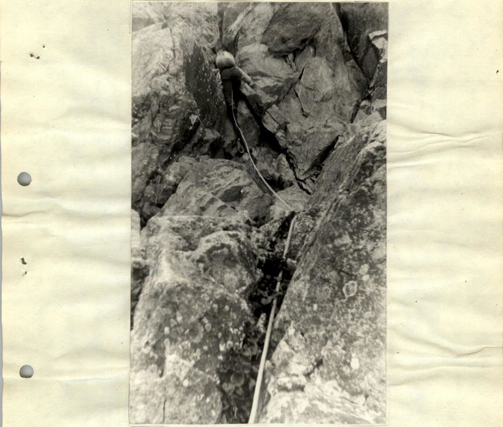
Pitons hammered: rock — 14; ice — none; bolt — none; chockstones — none
-
Number of travel hours from bivouacs to the summit — 8 hours, no bivouacs.
-
Full names of participants and their qualifications: Leonov V.V. — CMS Kuleshova E.V. — CMS
-
Team coach — Kapitanov O.V. — MS
-
Date of departure and return — July 18, 1981
Route Description
From the "Green Hotel" base camp, up the left orographic side of the Siama River. Cross the river in its upper part (in the first half of summer — snow bridge) and then move towards the Chetyrekh Pass. 100 m before the pass, start traversing the snow slope towards the rock island. A distinctive feature of the route are the triangles (five) through which the route passes, leading to the pre-summit ridge. The largest of them is the eastern bastion of the I tower of the Siama Crown. The route is limited on the right by a rugged rockfall-prone couloir, on the left — by the Chetyrekh Pass. From the rock island to the right, up to a wide talus shelf, where a signal cairn is built — simultaneous movement. Then left along the shelf, bypassing the wall, we reach the inclined slabs (20 m) — simultaneous movement. Up to the base of the bastion — 35 m. Belay is via pitons. The further route represents a monolithic wall 120 m long — the key section of the route. Belay is via pitons. 46 m from the start of the bastion, a control cairn is built. The relief of the bastion does not allow more than two people to gather at belay points. Average steepness of the bastion — 65°. The direction of movement along the bastion is from left to right, exiting onto its edge, bordering on the black dyke in the upper part. Then along the internal angle formed by the dyke and the edge, exit onto the northern ridge of the I tower. To the summit, movement is along the ridge — 200–250 m. On some sections of the ridge, variable belay through ledges is required. Descent from the summit is via the 2B category difficulty route. The route is recommended for a sports group (not more than 4 people) with good rock climbing training. Thin rock pitons of various lengths were used during the ascent (14 pieces). Optimal rope length on the route — 40 m.
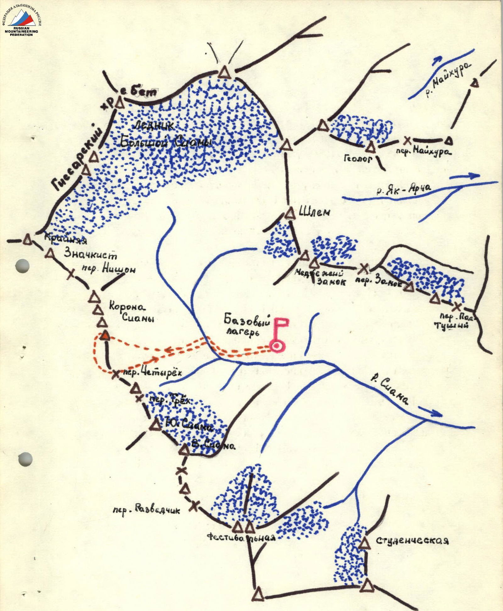
Siama Area Diagram
Table of Main Route Characteristics
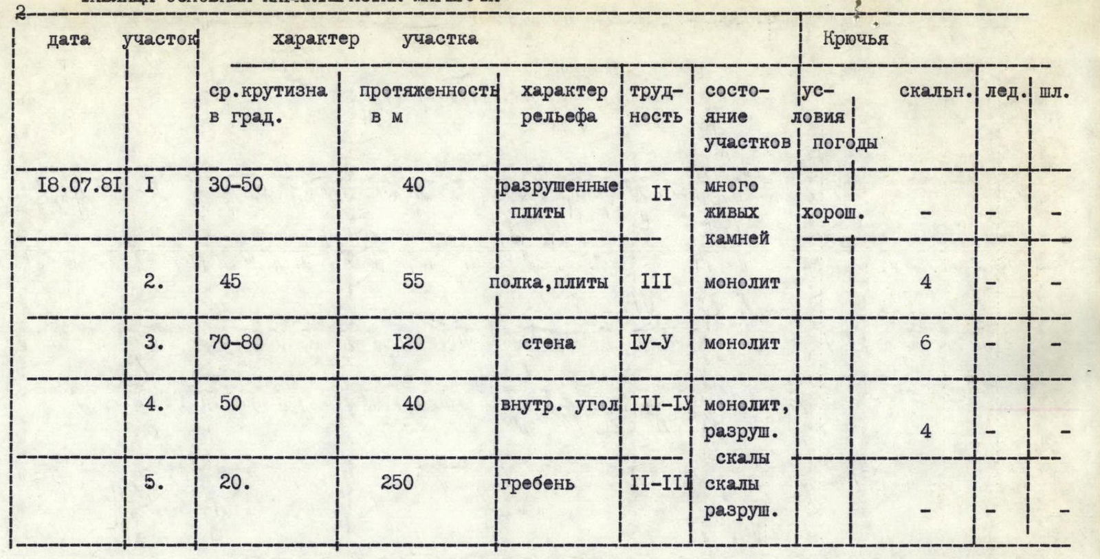
| Date | Section | Average steepness in degrees | Length in m | Terrain character | Difficulty | Section condition | Weather conditions | Pitons: rock | Pitons: ice | Pitons: bolt |
|---|---|---|---|---|---|---|---|---|---|---|
| July 18, 1981 | R1 | 30–50 | 40 | broken slabs | II | many loose rocks | good | – | – | – |
| R2 | 45 | 55 | shelf, slabs | III | monolithic | 4 | – | – | ||
| R3 | 70–80 | 120 | wall | IV-V | monolithic | 6 | – | – | ||
| R4 | 50 | 40 | internal angle | III-IV | monolithic, broken rocks | 4 | – | – | ||
| R5 | 20 | 250 | ridge | II-III | broken rocks | – | – | – |