Ascent Passport
I. Ascent category — Rock climbing II. Ascent area — Pamir-Alay, Hissar mountain range III. Ascent route — Zamin Karor peak, 3709 m, R0–R3 summit via the center of the West wall IV. Ascent characteristics elevation gain — 1150 m (total route elevation gain), steepness — 80° length of difficult sections — 940 m, including the lower rock belt — 1400 m) V. Pitons used: rock — 204, ice — none, bolted — 4 VI. Total climbing hours — 79 VII. Number of nights on the route: two, both sitting on ledges. VIII. Ascent participants: group from a/l "Varzob" Grushevsky V.G. — leader, Candidate for Master of Sports Shadskaya L.I. — participant, Candidate for Master of Sports Belyntsev V.I. — participant, Candidate for Master of Sports Kozlov P.V. — participant, Candidate for Master of Sports Shklyar G.Z. — participant, Candidate for Master of Sports Bakman A.R. — participant, Candidate for Master of Sports IX. Coach: Sogrina E.G. X. Ascent dates: June 13, 1978 — route preparation June 14, 1978 — start of ascent June 16, 1978 — reaching the summit and descending to the base camp
Sections 1 and 2
70 m of very steep rocks resembling "ram's foreheads" lead to a sheer wall of the bastion. In the right part... a crack is visible... to the right, a small cornice...
Explanatory note to the table
The ascent route passes through the center to R0–R3, the summit and massif of Zamin Karor, via the West wall, and is the second passage. The wall's vertical height exceeds 1 km. The steepness of the wall section of the route is slightly more than 80°. The wall's relief is technically extremely difficult. The rocks are primarily composed of marbleized limestones, heavily smoothed.
Consultations with the first ascensionists, a team from the Sports Committee of the Tajik SSR, and a reconnaissance sortie directly under the wall allowed us to establish that there is a starting path for the route that differs somewhat from that of the first ascensionists and is more logical and technically simpler. A steep, interrupted ledge was discovered, leading to the upper part of the "belly" — the black bastion. In all other respects, the route taken by the "Varzob" team exactly replicates that of the first ascensionists.
The group's tactics were planned as follows:
- Day 1:
- Processing and fixing ropes (240 m)
- Supplying part of the equipment and drinking water (18 l)
Next, the lead pair processes the path and fixes ropes (the first without a backpack), while the other participants move along the secured ropes with jumar. Backpacks are carried using the "American" method, i.e., suspended on a short cordelette from the harness. The group completely abandoned pulling backpacks up on the rope, which increased the pace of movement along the route. The tactical plan was fully adhered to.
The assault camp is set up on a terrace on the wall in the "birch grove", accessible by overcoming a 250-meter rock belt consisting of alternating walls with несложным лазанием and "ram's foreheads" and slabs. On the day of preparation, a steep ledge and the beginning of a giant internal angle are covered. 230 m of ropes are fixed. Drinking water and part of the equipment are supplied to the wall. The "processors" return to the assault camp.
On June 14, the group passes the processed sections and begins further movement. The route goes through an internal angle with a cleft. Climbing is extremely difficult. The angle leads to the "foreheads" of light-gray limestone, forming a wall. Holds are very small; climbing is difficult. Above, again an internal angle, but wider than in the lower part. Walls are sheer, composed of blocks of light-gray limestone. Ascent is along the right side of the angle. The angle ends in a cornice, which is bypassed on the left through a 3-meter overhang by free climbing. Further, there is a 30-meter smoothed wall of rocks resembling "ram's foreheads". Climbing is very difficult.
A narrow ledge leads under a cornice, which is passed on ladders, and then an internal angle and very steep "ram's foreheads". It is decided to stay overnight on the ledge under the cornice; the overnight stay is sitting and semi-suspended. The lead rope processes the path further and fixes another rope (60 m): "Ram's foreheads" end in a wall of rock "feathers", with a steepness of 90°; holds are fragile. Climbing is extremely difficult, and there is a significant psychological load. The next section is no less difficult — a sheer, and in some places overhanging, wall. However, there are many cracks. This facilitates movement. Ladders are used. The wall ends in a ledge where one can rest a bit. Further up, a sheer, wide chimney with a cork, somewhat overhanging in the upper part, goes up. Under the cork, there is a transition to the left wall of the chimney and, via a cleft, an exit to a wall of smoothed rocks of light-gray limestone. Next is a ledge under an overhang of huge limestone blocks. Overnight stay. The pair continues to process the path for the next day. The path is very difficult: a smooth slab-wall. There are practically no holds. Ladders and bolted pitons are used. The next day, we ascend via the fixed ropes under the cornice. Here, there are cracks. The cornice is passed using a platform and ladders. Behind it is an internal angle, which is traversed along its left wall and leads to a small ledge. Further — another cornice. Climbing is extremely difficult. Again, ladders are used. Having overcome a 40-meter wall by free climbing, the group reaches the summit ridge. Along the not steep, with good holds, rocks of the ridge, we approach under the summit tower and then — to the summit. On the same day, we descend down to the base camp under the wall.
Group leader V. Grushevsky
Table of main characteristics of the ascent route
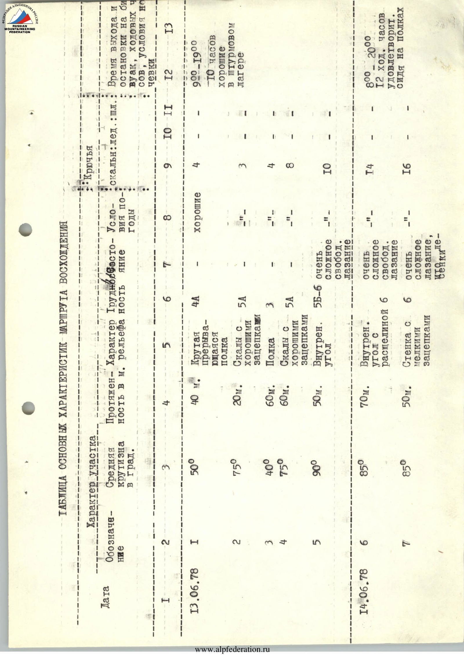
| Date | Designation | Average steepness in degrees | Length in m. | Character of relief | Difficulty | Weather conditions | Pitons: rock | Pitons: ice | Pitons: bolted | Time of departure and stop for bivouac | Climbing hours | Overnight conditions |
|---|---|---|---|---|---|---|---|---|---|---|---|---|
| June 13, 1978 | R1 | 50° | 40 m | Steep interrupted ledge | 4 | good | 4 | — | — | 9:00–19:00 | 10 h | good in the assault camp |
| R2 | 75° | 20 m | Rocks with good holds | 5 | — | 3 | — | — | ||||
| R3 | 40° | 60 m | Ledge | 3 | — | 4 | — | — | ||||
| R4 | 75° | 60 m | Rocks with good holds | 5 | — | 8 | — | — | ||||
| R5 | 90° | 50 m | Internal angle, very difficult free climbing | 5–6 | — | 10 | — | — | ||||
| June 14, 1978 | R6 | 85° | 70 m | Internal angle with a cleft, very difficult free climbing | 6 | T4 | 16 | — | — | 8:00–20:00 | 12 h | satisfactory sitting on ledges |
| R7 | 85° | 50 m | Wall with small holds, very difficult climbing, Chelyakievskie | 6 | — | 10 | — | — | ||||
| R8 | 90° | 60 m | Bypassing a cornice along a sheer rock with several holds and an overhang. Transition to an internal angle. Its left wall — smooth, smoothed rocks | 6 | cloudy, light rain | 17 | — | — | ||||
| R9 | 95° | 3 m | Overhanging rocks-cornice | 6 | satisfactory cloudiness | 2 | — | 1 | ||||
| R10 | 85° | 30 m | Ram's foreheads, heavily smoothed limestone, covered with fine dust (slippery) | 5 | satisfactory, occasional rain | 6 | — | — | ||||
| June 15, 1978 | R11 | 95° | 2 m | Cornice | 6 | satisfactory cloudiness, wind | 3 | — | — | 9:00–21:00 | 13 h | satisfactory sitting on a ledge |
| R12 | 90° | 10 m | Internal angle with a cleft | 5 | — | 4 | — | — | ||||
| R13 | 85° | 100 m | Ram's foreheads, transitioning into a wall | 5 | — | 18 | — | 1 | ||||
| R14 | 90° | 10 m | Overhanging rock feathers | 6 | — | 4 | — | — | ||||
| R15 | 90° | 20 m | Wall with a slight overhang | 6 | — | 10 | — | — | ||||
| June 16, 1978 | R16 | 85° | 20 m | Chimney with a cork at the top | 5 | — | 5 | — | — | 7:00–21:00 | 14 h | — |
| R17 | 80° | 50 m | Smoothed wall of light limestone | 5 | cloudy, light rain | 6 | — | — | ||||
| R18 | 85° | 20 m | Wall | 5 | satisfactory cloudiness | 3 | — | — | ||||
| R19 | 85° | 50 m | Smooth wall transitioning into a slab, practically without holds | 6 | good | 14 | — | 2 | ||||
| R20 | 100° | 5 m | Cornice | 6 | — | 8 | — | — | ||||
| R21 | 90° | 20 m | Wall with a slit | 6 | — | 12 | — | — | ||||
| R22 | 85° | 25 m | Internal angle along the left wall | 5 | — | 5 | — | — | ||||
| R23 | 100° | 5 m | Overhanging wall-cornice | 6 | — | 6 | — | — | ||||
| R24 | 85° | 40 m | Wall with good holds | 5 | — | 5 | — | — | ||||
| R25 | 70° | 150 m | Slabs and ram's foreheads, light-gray limestone | 5 | — | 17 | — | — |
Reaching the summit; descending to the base camp.
