Ascent Passport
- Ascent class — rock climbing.
- Ascent area — Pamir-Alay, Gissar Ridge, Yaghnob Wall area.
- Peak, its height, and ascent route — Zamin-Karor West shoulder, 3910 m, via the center of the NW wall.
- Estimated difficulty category — 4A.
- Height difference (from the base of the wall) — 1100 m.
- Average steepness — 60°.
- Total route length — 1600 m.
- Length of sections: 1st cat. diff. — 230 m; 2nd cat. diff. — 100 m; 3rd cat. diff. — 580 m; 4th cat. diff. — 420 m; 5th cat. diff. — 140 m.
- Number of pitons driven:
| for belaying | for creating ITO | |
|---|---|---|
| rock | 67 | 3 |
| ice | — | — |
| bolt | — | — |
| stoppers | 4 | 4 |
- Number of climbing hours — 13.
- Number of overnight stays — none.
Group composition
-
Virchenko Yu.P. — leader — 2nd sports category.
-
Lebedev A.B. — 2nd sports category.
-
Shvets A.B. — 2nd sports category.
-
Fedorov A.G. — 2nd sports category.
-
Leibfreid M.A. — 2nd sports category.
-
Team coach: Poberezovsky V.I.
-
Date of departure for the route — August 12, 1980, date of return — August 12, 1980.

Ascent route via the NW wall through the cave, category 4B.
Brief description of the approach to the route
The Zamin-Karor massif (Yaghnob Wall) is located in a spur of the Gissar Ridge, east of the Anzob Pass. The massif is connected to the main watershed of the Gissar Ridge by a high ridge, on which the Khosilot peak (4626 m) is located. To the north of the Yaghnob Wall are individual peaks reaching 4000 m. Along the entire northern foot of the Yaghnob Wall, a narrow strip of glacier is located. The massif is bounded by the Pindor River valley to the west and the Tagrich River valley to the east, both flowing into the Yaghnob River. The approach to the Yaghnob Wall is as follows:
- First, by road from the mouth of the Yaghnob River to the village of Upper Margib, located at the mouth of the Pindor River;
- Then by trail, starting 200 m above the village;
- The trail ascends to a plateau under the NW walls of Zamin-Karor;
- The ascent takes 1 hour.
On the plateau near a stream is a convenient location for a base camp. The base camp is at an elevation of 2694 m. To the southeast of the base camp rises the NW wall of the Zamin-Karor West shoulder peak. On this wall, heavily destroyed in its upper part, two fairly distinct ridges can be identified, descending from the crest to the base of the wall. The route begins to the left of a standalone protrusion (finger) standing out in the lower part of the left ridge, 100 m above the base of the wall.
The approach to the route is as follows:
- First, by trail along the left (orographic) bank of the stream towards the Central Pass;
- Then from the trail to the right, up the scree to a snow tongue located at the base of the wall under the finger;
- The approach takes 1 hour.
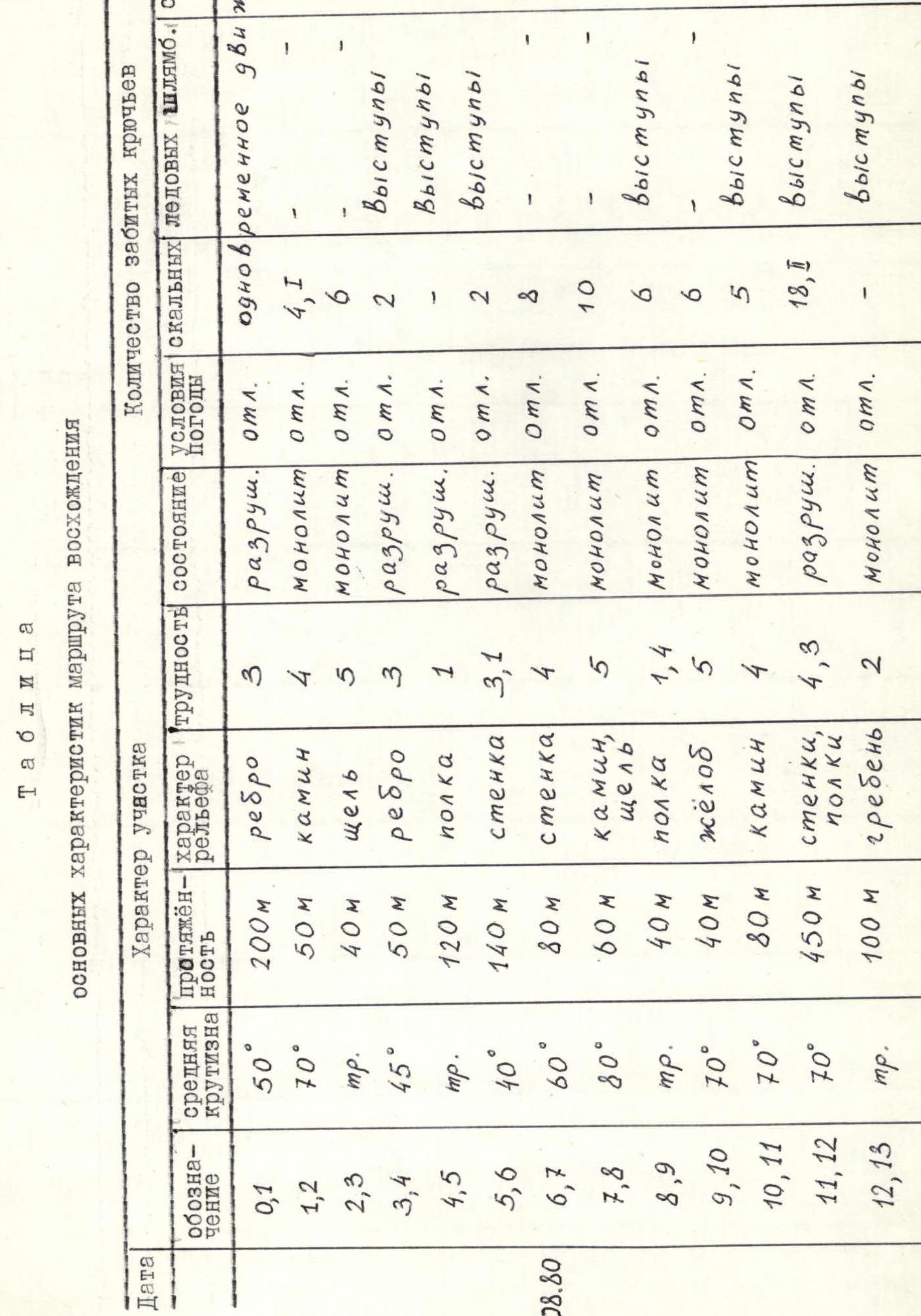
Table of main characteristics of the ascent route
| Designation | Average steepness | Length | Terrain character | Difficulty | Condition | Weather conditions | Rock | Ice | Bolt | Stoppers |
|---|---|---|---|---|---|---|---|---|---|---|
| R0–R1 | 50° | 200 m | ridge | 3 | destroyed | good, simultaneous movement | 0 | 0 | 0 | 0 |
| R1–R2 | 70° | 50 m | chimney | 4 | monolith | good | 4 | 0 | 0 | 1 |
| R2–R3 | steep | 40 m | crack | 5 | monolith | good | 6 | 0 | 0 | 2 |
| R3–R4 | 45° | 50 m | ridge | 3 | destroyed | good, ledges | 2 | 0 | 0 | 0 |
| R4–R5 | steep | 120 m | shelf | 1 | destroyed | good, ledges | 0 | 0 | 0 | 0 |
| R5–R6 | 40° | 140 m | wall | 3, 1 | destroyed | good, ledges | 2 | 0 | 0 | 0 |
| R6–R7 | 60° | 80 m | wall | 4 | monolith | good | 8 | 0 | 0 | 0 |
| R7–R8 | 80° | 60 m | chimney, crack | 5 | monolith | good | 10 | 0 | 0 | 6 |
| R8–R9 | steep | 40 m | shelf | 1, 4 | monolith | good, ledges | 6 | 0 | 0 | 0 |
| R9–R10 | 70° | 40 m | groove | 5 | monolith | good | 6 | 0 | 0 | 0 |
| R10–R11 | 70° | 80 m | chimney | 4 | monolith | good, ledges | 5 | 0 | 0 | 0 |
| R11–R12 | 70° | 450 m | walls, shelf | 4, 3 | destroyed | good, ledges | 18 | 0 | 0 | 1 |
| R12–R13 | steep | 100 m | ridge | 2 | monolith | good, ledges | 0 | 0 | 0 | 0 |
Explanation for the table
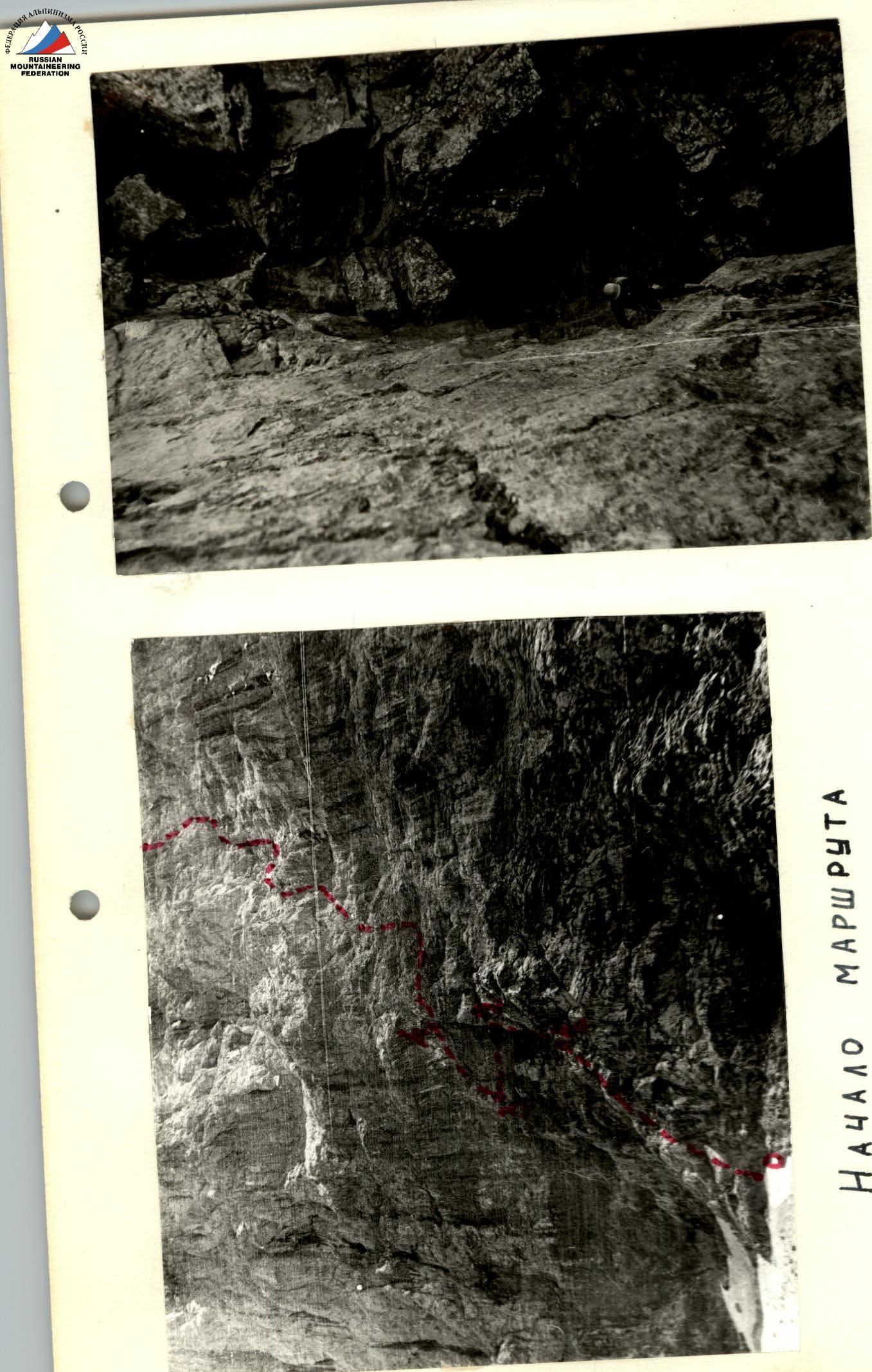
After preliminary observation of the wall, an objectively safe route variant was chosen via the NW wall of the Zamin-Karor West shoulder peak. The route passes from the snow tongue at the base of the wall, to the left of a rock outcrop (finger), towards a pronounced groove in the center of the wall, to the left of a cave and to the right of a rock ridge formed by reddish rocks. The route then follows the groove and exits to the destroyed upper part of the NW wall, moving along which by the most logical path — exit to the ridge.
On August 12, 1980, at 6:00, the group departed from the base camp located on the plateau before the Zamin-Karor massif to the route. Having overcome the scree, the group approached the base of the NW wall of the Zamin-Karor West shoulder peak to the snow tongue to the left of the finger.
Movement along the route was carried out as follows:
Section R0–R1: From the snow tongue upwards along moderately difficult destroyed rocks — exit under the finger and, bypassing it to the left, along easy rocks — approach to a wide vertical crack turning into a chimney in its upper part (0.5 hour).
- Length of section: 200 m
- Average steepness: 50°
Section R1–R2: Upwards along the vertical crack, and then along the chimney intersected by two shelves. The chimney ends in a large niche with a convenient belay location. Climbing is above average difficulty (5 rock pitons). Total length of section 50 m. Average steepness — 70°. The group took 1 hour to overcome this section.
Section R2–R3: From the niche to the left along a horizontal crack, partly turning into a narrow shelf, traverse 40 m to the end of the crack (1 hour). Climbing is difficult (6 rock pitons, 2 stoppers). The first person climbs without a backpack.
Section R3–R4: From the end of the crack to the right and upwards along destroyed rocks 50 m to a horizontal shelf (0.5 hour). Climbing is of moderate difficulty. Belaying via ledges and pitons (2 rock pitons). Average steepness 45°.
Section R4–R5: Along the horizontal shelf traverse to the right 120 m to a place with a noticeably reduced slope. The rocks in this area are light gray with a reddish tint (15 minutes). Movement is simultaneous. Belaying via ledges.
Section R5–R6: To the left and upwards 60 m to the next shelf along moderately difficult rocks. Steepness 45°. Belaying is via pitons and ledges (2 rock pitons). Along an inclined shelf (steepness 25–30°) traverse to the left 80 m to an inclined crack going upwards to the right. Movement is simultaneous (0.5 hour).
Section R6–R7: Along the crack to the right and upwards 80 m along rocks above moderate difficulty to the base of a small 4-meter chimney (1 hour). Belaying is via pitons and ledges (8 rock pitons. Pitons are hard to drive). Average steepness 60°.
Section R7–R8: Key section. Along a vertical chimney 4 m, and then along a vertical crack into which the chimney turns — exit to a wide reddish shelf (1.5 hours). Climbing is difficult. Rocks are of 5th category difficulty. Legs work mainly on friction during climbing. ITO is used. Belaying is via pitons and stoppers (10 rock pitons, 6 stoppers). The first person climbs without a backpack. Length of section 60 m. Average steepness 80°.
Section R8–R9: Along the inclined reddish shelf traverse to the right 40 m to a pronounced groove with heavily smoothed rocks. At the end of the shelf above it, there is an overhang, which greatly hinders movement due to a very narrow passage. In this place, the first person climbs without a backpack (1 hour). Belaying is via pitons and ledges (6 rock pitons).
Section R9–R10: Upwards along the groove 40 m to a scree shelf (1.5 hours). Movement is difficult, holds are very smoothed. The first person climbs without a backpack. Belaying is via pitons, pitons are hard to drive (6 rock pitons). Average steepness 70°. Along the scree shelf traverse to the right — approach to a small cave with an opening in the ceiling. In the cave is a control cairn. To the right of the cave is a small wall with a steepness of 60° with small holds, leading to the next shelf. However, a simpler exit to the shelf is through the opening in the cave ceiling.
Section R10–R11: Through the cave — exit to a shelf, at the back of which is a chimney. Along the chimney 40 m upwards, then along moderately difficult rocks to the left and upwards 40 m to a small shelf (1 hour). Belaying is via pitons and ledges (5 rock pitons). Average steepness 70°.
Section R11–R12: Further path to the ridge represents an alternation of short walls (5–10 m) with short shelves or small platforms. There are no noticeable landmarks. By the most logical path, moving mainly straight up — exit to the ridge. Climbing is above moderate difficulty. Before the ridge — 40 m of complex climbing (2 hours). Belaying is via pitons and ledges (about 20 rock pitons). Total length 400–450 m. Average steepness 70°.
Section R12–R13: Traverse to the left along the ridge to the summit along easy rocks. Movement is simultaneous. Belaying via ledges. Length of section 100 m (15 minutes).
Descent to the south is easy and passes along slabs and scree slopes by a route not exceeding category 2B.

Route profile: visible sections of the route, invisible sections of the route.
Conclusion about the route and recommendations
The route passed is technically complex. It is characterized by a large amount of rock climbing (including rocks of 4th and 5th category difficulty) compared to 4A category routes in the Caucasus. Passing this route requires a sufficiently high level of technical rock climbing and psychological preparation from climbers. The route is purely rock — completely devoid of ice, snow, and practically water.
Overall, the climatic conditions for climbing in the area should be considered favorable. This allows for taking a minimum of camping gear on the route. The weight of participants' backpacks was no more than 6 kg.
The rock relief on the route is very diverse. The rocks are composed of marbleized limestones, partly heavily smoothed. In some areas, driving pitons is very challenging. The route was passed mainly by free climbing (in climbing shoes). On sections R2–R3, R7–R8, R8–R9, R9–R10, the first person in the group climbed without a backpack. On section R7–R8, ladders were used.
The sports qualification (all participants had sports categories in rock climbing) and the group's cohesion allowed them to pass this route at a good pace and reliably cope with technical difficulties. The group members in this composition had previously passed the following routes:
- Cheget-Kara via the NW ridge, category 3B.
- Cheget-Kara via the NW counterfort, category 4A.
- Traverse of MNR from SW to NE, category 3B.
- MNR SW via the S ridge, category 4A.
- Peak Vladivostok via the W ridge, category 3B.
- Peak Vladivostok via the NE ridge, category 3B.
- Zamin-Karor West shoulder via the NW wall through the cave, category 4B.
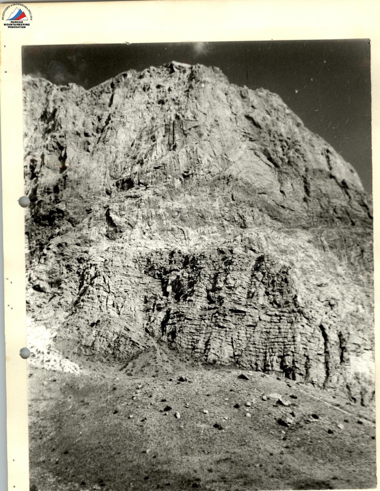
General view of the Zamin-Karor West shoulder peak.


