Climbing Certificate
- Type of ascent — high-altitude and technical.
- Area of ascent — Pamir-Alay, Gissar Range.
- Peak — Zamin-Karor 1st Western (4303 m) via the NW wall, a combination of the Yefimov and Kapitanov routes.
- Difficulty category — proposed 6B.
- Route characteristics:
- height difference — 1300 m;
- total length — 1500 m;
- average steepness of the wall section 82°;
- length of sections with V–VI difficulty — 1250 m.
- Number of pitons used:
- rock pitons — 152+5ˣ(42+2ˣ);
- chocks — 84 (30);
- friends — 44 (21);
- ice screws — 0 (0);
- bolt pitons — 4+35ˣ(20ˣ);
- sky-hooks — 43;
- Fifi hooks — 11.
- Number of climbing hours — 61 hours (including processing); days — 4 (including descent) + 2 days of processing.
- Overnights — 3, all on ledges; 1 and 2 are bivouac sacks.
- Names, initials of the team leader, participants, and their qualifications:
| captain: | Volodin V.G. | Master of Sports |
|---|---|---|
| participants: | Kozlov G.S. | 1st sports category |
| Kochetkov G.S. | 1st sports category | |
| Savelyev D.S. | 1st sports category |
- Team coach: Volodin V.G., Timme E.A.
- Dates of departure and return to base camp:
| — departure on the route | August 16, 2005 |
|---|---|
| — reaching the summit | August 21, 2005 at 11:00 |
| — return to BC | August 21, 2005 |
- Organizing body — CSKA named after A.S. Demchenko.
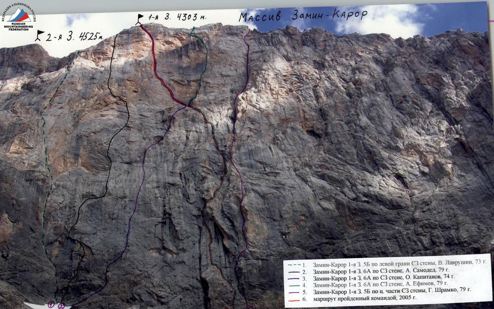
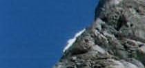
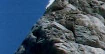
General Photo of the Wall
- Zamin-Karor 1st W. 5B on the left edge of the NW wall, V. Lavrushin, 1973.
- Zamin-Karor 1st W. 6A on the NW wall, A. Samoded, 1979.
- Zamin-Karor 1st W. 6A on the NW wall, O. Kapitanov, 1974.
- Zamin-Karor 1st W. 6A on the NW wall, A. Yefimov, 1979.
- Zamin-Karor 1st W. 5B on the central part of the NW wall, G. Shramko, 1979.
- The route climbed by the team, 2005.
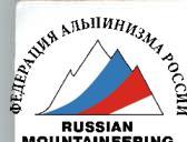
Profile Diagram of the Route
Left Wall Profile Photo
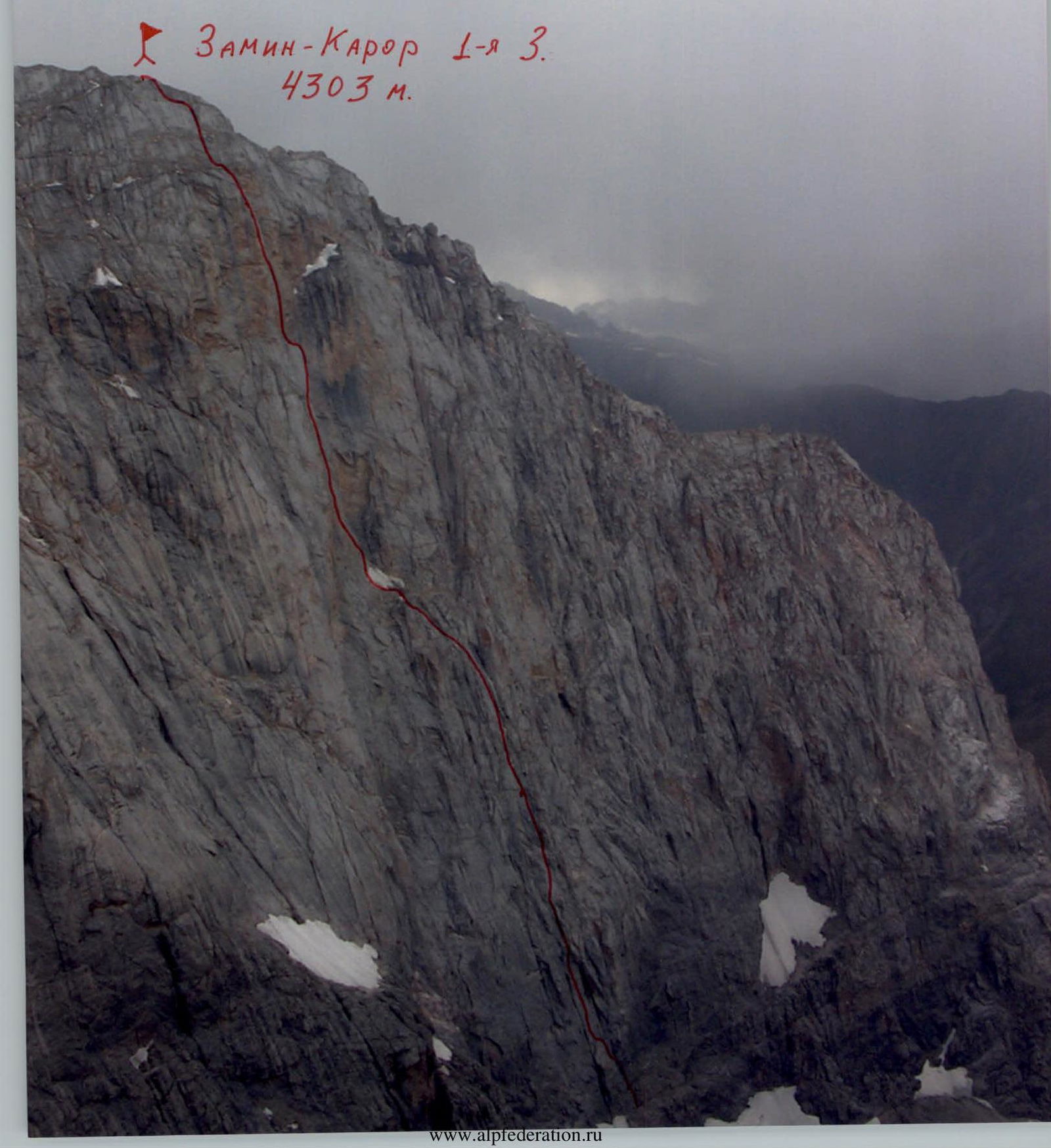 Zamin-Karor 1st Western, 4303 m.
Area Map
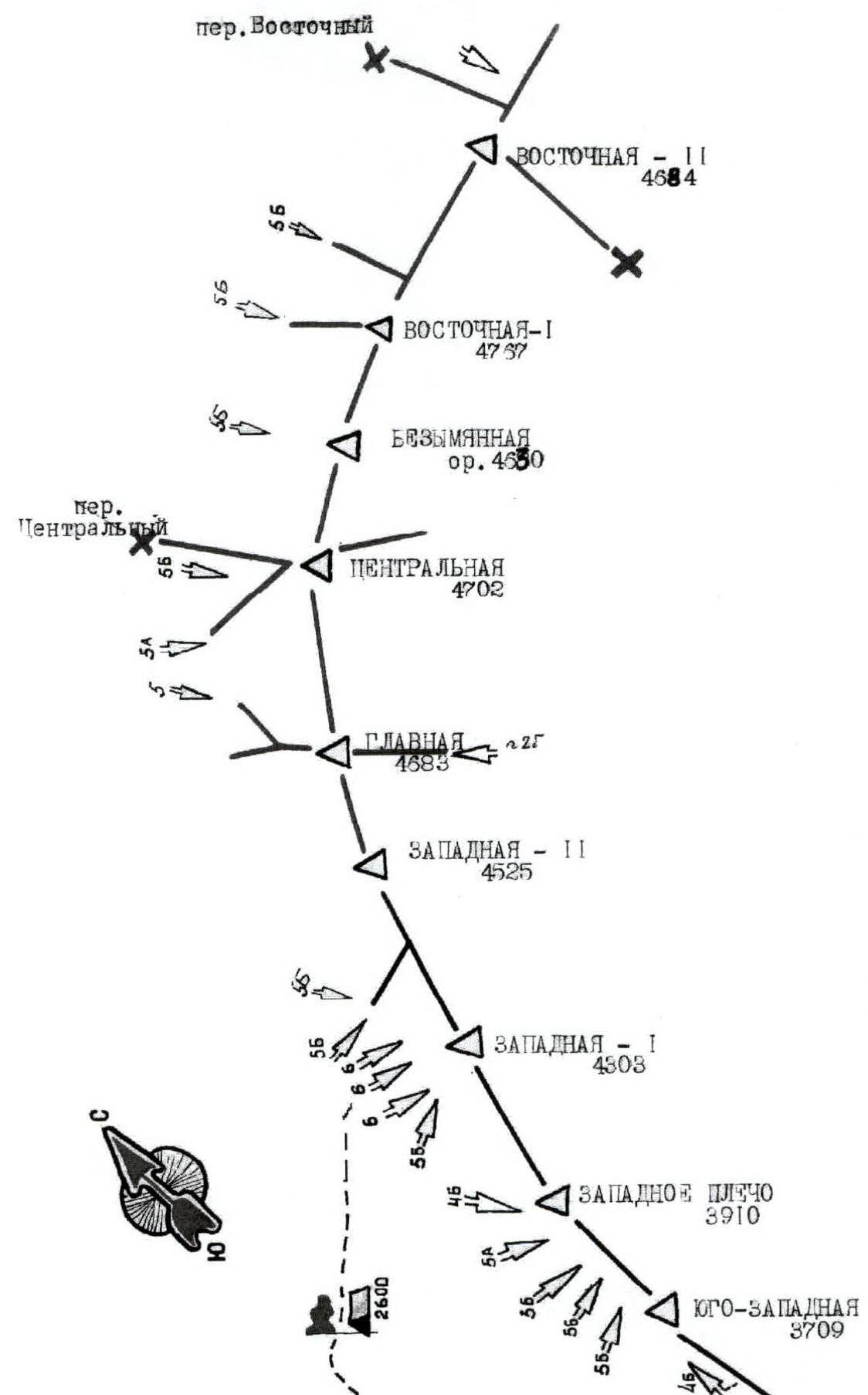
Fig. 1. Ascent Area Diagram
Massif Panorama
The Zamin-Karor massif (Yaghnob Wall) is located in a spur of the Gissar Range, east of the Anzob Pass. The massif is connected to the main watershed of the Gissar Range by a high ridge, where the peak Khosilot (4625 m) is located. To the north of the Yaghnob Wall are individual peaks reaching 4000 m.
Along the entire northern foot of the Yaghnob Wall, a narrow strip of glacier is located.
The massif is bounded:
- to the west — by the Pindor River valley,
- to the east — by the Tagrich River valley, both rivers flow into the Yaghnob River.
The Zamin-Karor massif stretches in a latitudinal direction for 8 km. The highest point is Eastern Zamin-Karor, 4767 m. The eastern part of the wall has significant glaciation from the north. The western part of the massif is purely rocky, with significant steepness.
Although the area is known for relatively stable hot weather, in recent years, the Pamir-Alay region has experienced poor and unstable weather in August. This was confirmed during the training camp near the Yaghnob Wall. Out of 25 days of the UTS, about 20 were marked by bad weather, accompanied by:
- heavy rainfall,
- even snowfall.
It should be noted that the Yaghnob Wall area had not been visited by climbers for 15 years. Obtaining any consultation on the condition and choice of routes was not possible.
After analyzing descriptions and reports, the choice of the ascent route was made on a combination of the Yefimov and Kapitanov routes on the 1st Western peak of the Zamin-Karor massif via its NW wall (4303 m), as the most complex and lengthy combination of routes in this area. The climbed route leads directly to the summit and retains its logic and feasibility.
The route is complex and requires:
- comprehensive preparation of the team members,
- experience in climbing complex wall routes of great length and steepness.
The wall relief is technically extremely difficult. The main forms of relief are walls with a minimal number of cracks, often smoothed. The significant overhang of the upper part of the route, above the snow ledge, is noteworthy. Many overhanging, opening internal corners and chimneys are inconvenient for both free climbing and artificial technical climbing (ITC).
Thus, based on the reports of the Yefimov (lower part, up to the snow ledge) and Kapitanov (above the snow ledge) teams on their first ascents, a предполагаемая «нитка» for the ascent was formed.
Organizational and Tactical Plan of the Ascent
Before climbing the wall, the team conducted a visual observation of the route, outlined the "thread" of the path, identified key areas, and possible overnight locations. Reports of previously climbed teams were reviewed.
According to the plan, considering the bad weather conditions, two days were allocated for processing the wall. Three overnight stays were planned directly on the route. All turned out to be lying on ledges, with two being bivouac sacks.
In the Yaghnob Wall area, CSKA named after Demchenko conducted a training camp this year. Thus, a group of observers and a rescue team consisting of qualified athletes were present in the base camp during the ascent, in agreement with other camp members.
Before departing on the route, all team members in the summer 2005 season had climbed various routes with 5B–6A difficulty in different mountain systems, and also participated in the Russian Championship in Erydag, where they ranked 4th. The team had also climbed two routes on the Zamin-Karor SW peak:
- on the right part of the 3rd wall, 5A;
- by the shortest path on the 3rd wall, 5B.
Communication between the team and the base camp was carried out using Motorola VHF radios.
The tactical plan was as follows:
- August 16, 2005 — departure from the base camp. Processing of 3 ropes on the lower part of the Yefimov route. Return to the base camp.
- August 17, 2005 — departure from the base camp. Processing of 3 ropes. Return to the base camp.
- August 18, 2005 — departure from the base camp. Start. Climbing part of the route to overnight stays under the snow ledge. Processing.
- August 19, 2005 — climbing the previously anchored belays. Climbing the section to a huge overhanging internal corner. Processing.
- August 20, 2005 — climbing the previously anchored belays. Climbing as much of the remaining wall as possible. Overnight on the summit.
- August 21, 2005 — descent from the summit.
In general, the tactical plan was followed, and the team successfully reached the summit on August 21, 2005, and descended to the base camp on the same day.
During the ascent, modern climbing equipment was used:
- main rope — 4 × 50 m;
- auxiliary cord — 15 m;
- rock hammer — 2 pcs.;
- rock pitons — 20 pcs. (of various purposes);
- anchor pitons — 7 pcs.;
- Fifi hooks — 2 pcs.;
- axes — 3 pcs.;
- sky-hooks — 6 pcs. (of various purposes);
- chock stones — 25 pcs.;
- friends — 8 pcs.;
- slings (of various lengths) — 5 pcs.;
- quickdraws (of various lengths) — 30 pcs.;
- claw hooks — 1 pair;
- ladders — 1 pair;
- bolt kit — 1 set;
- personal and bivouac gear sets.

Weather conditions:
- August 16, 2005 — rain throughout the day.
- August 17, 2005 — cloudy weather in the afternoon, rain.
- August 18, 2005 — sunny during the day. Strong rain after 16:00.
- August 19, 2005 — clear weather. Wind picked up towards evening.
- August 20, 2005 — light cloudiness. Relatively clear.
- August 21, 2005 — sunny. Quite cold.
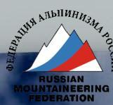
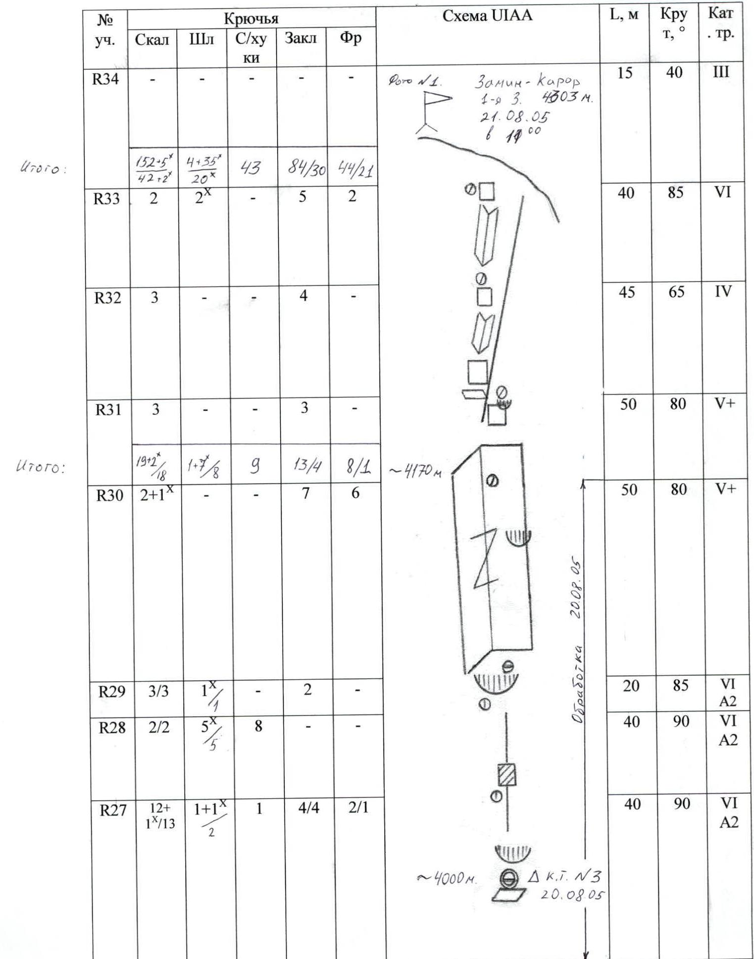
Route Diagram in UIAA Symbols
| Pitch # | Rock | Bolt | Sky-hooks | Chocks | Friends | UIAA Diagram | L, m | Steepness, ° | Difficulty |
|---|---|---|---|---|---|---|---|---|---|
| R0 | - | - | - | - | - | 400 | 30–45 | III | |
| R1 | 5 | - | - | 7/3 | 5/2 | 45 | 80–95 | VI A1 | |
| R2 | 1 | - | - | 5 | 2 | 35 | 75 | V+ | |
| R3 | 5/5 | 6ˣ/6ˣ | 8 | 4/3 | 3 | 40 | 85 | VI A2 | |
| R4 | - | - | 7ˣ/17ˣ | 7 | - | 45 | 80 | VI A2 | |
| R5 | 2/2 | 5ˣ/5ˣ | 5 | - | - | 40 | 85 | VI A2 | |
| R6 | 4/2 | - | - | 5/1 | 3 | 35 | 70–95 | V+, 10 m VI A2 | |
| R7 | 3 | - | - | 5 | 4 | 45 | 75 | V+ | |
| R8 | 3+1ˣ/12 | - | - | 5 | 2 | 40 | 90 | VI A1 | |
| R9 | 3 | - | - | 6 | 2 | 40 | 70 | V+ | |
| R10 | 2 | - | - | 5 | 4 | 45 | 75 | V+ | |
| R11 | - | - | - | - | - | 25 | - | III | |
| R12–R13 | 8/6 | - | - | 9/5 | 6 |  | 100 | 85 | VI A2 |
| R14–R17 | 15/2 | 3 | 2 | 16/1 | 10 | 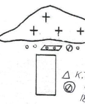 | 180 | 70–80 | V+ 5m VI A2 |
| R18 | - | - | - | - | - | 75 | 40 | III | |
| R19 | 5 | - | - | 7 | 2 | 50 | 90–95 | VI | |
| R20 | 4 | - | - | 6/2 | 3 | 35 | 80 | VI A1 | |
| R21 | 4/1 | - | - | 7/5 | 4/2 |  | 45 | 120 | VI A2 |
| R22 | 3 | - | - | 8 | 3 | 35 | 95 | VI | |
| R23 | 3 | - | - | 8 | 5 | 40 | 80 | V+ | |
| R24 | 2 | - | - | 6/4 | 4/2 | 40 | 90–100 | VI A2 | |
| R25 | 5/4 | - | - | 7/7 | 5/5 | 45 | 95 | VI A2 | |
| R26 | 2/2 | 2ˣ/2ˣ | - | 4/3 | 3/3 | 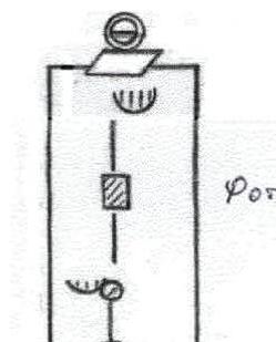 | 30 | 110 | VI A2 |
| R27 | 12+/1ˣ/13 | 1+1ˣ/2 | 1 | 4/4 | 2/1 | 40 | 90 | VI A2 | |
| R28 | 2/2 | 5ˣ/5ˣ | 8 | - | - | 40 | 90 | VI A2 | |
| R29 | 3/3 | 1ˣ/1ˣ | - | 2 | - | 20 | 85 | VI A2 | |
| R30 | 2+1ˣ/18 | 1-7ˣ/8 | 9 | 13/4 | 8/1 | 50 | 80 | V+ | |
| R31 | 3 | - | - | 3 | - | 50 | 80 | V+ | |
| R32 | 3 | - | - | 4 | - | 45 | 65 | IV | |
| R33 | 2 | 2ˣ | - | 5 | 2 | 40 | 85 | VI | |
| R34 | - | - | - | - | - | 15 | 40 | III |
Route Description by Pitches
R0 — The snow slope leads to the base of the NW wall, then right along the snow "tongue" and the "ram's foreheads" to the "unit" (a large delamination in the form of a unit). The wall section of the Yefimov route begins here. 400 m, 30–45°, III.
R1 — The wall has an overhang in the middle part. Climbed with partial use of ITC. 45 m, 80–95°, VI A1.
R2 — A wet internal corner leads to the top of the "unit". 35 m, 75°, V+.
R3–R5 — A smooth slab-"mirror". Climbed using sky-hooks. Protection is bolted. The belay point is in a comfortable niche on bolts. 125 m, 85°, VI A2.
R6 — Through a wall and a chimney, pass right through an overhang via a "split-off". Control spur. 35 m, 70–95°, V+, 10 m VI A2.
R7 — A destroyed internal corner. 45 m, 75°, V+.
R8 — The internal corner turns into a chimney with an overhang. Wet and dirty. Rocks are heavily destroyed. 40 m, 90°, VI A1.
R9–R10 — Monolithic slabs separated by ledges. Many loose stones. 40 m, 75°, V+.
R11 — An inclined slab leads to the base of an internal corner (traverse). 25 m, III.
R12–R13 — A series of internal corners and cracks, dirty and wet. 100 m, 85°, VI A2.
R14–R17 — Slabs with cracks and an internal corner leading to a large snow ledge at the base of the "goblet". 180 m, 70–80°, V+, 5 m VI A2.
R18 — Bypassing the snow on the left, exit into the "goblet". 75 m, 40°, III.
R19–R20 — A series of cracks climbed by free climbing, partially on ITC. 85 m, 80–95°, VI A1.
R21 — A huge overhanging, opening internal corner-chimney. Extremely difficult climbing. 45 m, 120°, VI A2.
R22 — A wall with two cornices. Difficult climbing. 35 m, 95°, VI.
R23 — An internal corner turning into a chimney. Pleasant climbing. 40 m, 80°, V+.
R24 — An opening, overhanging chimney. Then left along the internal corner. 40 m, 90–100°, VI A2.
R25 — An overhanging crack. ITC used. 45 m, 95°, VI A2.
R26 — A very difficult crack to climb. Ends with a cornice. Exit to a ledge. 30 m, 110°, VI A2.
R27 — Bypassing the cornice on the left, exit into a "blind" crack climbed using ITC. 40 m, 90°, VI A2.
R28 — The crack turns into bare slabs. Sky-hooks. Bolt protection. 40 m, 90°, VI A2.
R29 — First on ITC, then climb under a large internal corner-"book", bypassing the cornice on the right. 20 m, 85°, VI A2.
R30 — Overcome the internal corner by free climbing. Good protection. 50 m, 80°, V+.
R31 — Along inclined slabs (inside a "bowl") exit to a ledge. Limited protection. 50 m, 80°, V+.
R32–R33 — Upwards along internal corners and slabs to the left of the ridge, exit to the main ridge. 85 m, 70–85°, VI.
R34 — Along the ridge, walk to the summit. 15 m, 40°, III.