Ascent Log
- Ascent category — technical
- Ascent area, Pamir-Alay range, Kichik-Alay ridge
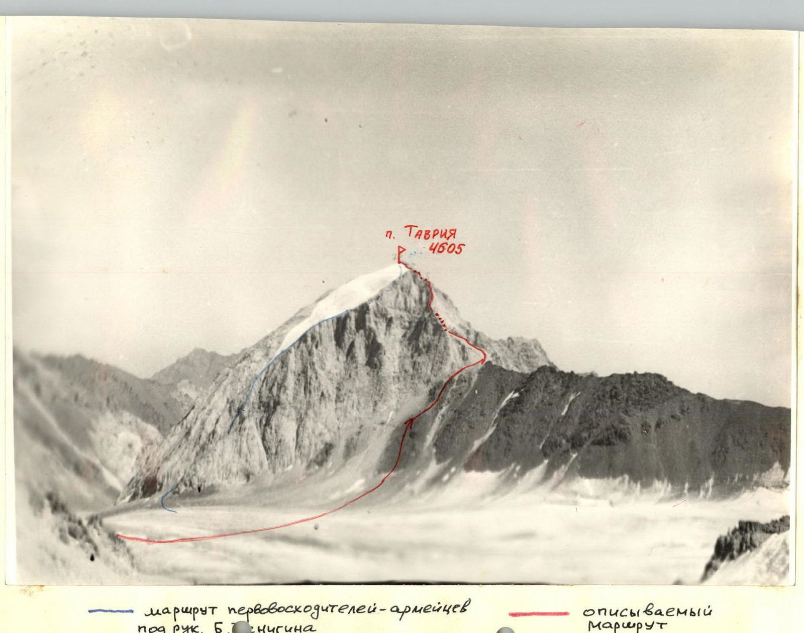
- Peak Tavriya, height 4605 m, ascent route via the western ridge
- Proposed category difficulty 2B
- Route characteristics: elevation gain 800 m, section length 5–6 km, average slope 40°
- Pitons hammered: For belay: Rock — 8 Ice — - Bolt — - For creating RPS (Rope Protection System): Rock — - Ice — - Bolt — -
- Number of travel hours — 5.9
- Number of overnight stays and their characteristics: one — at Joldjilga pass in a tent
- Full name of the leader, participants, and their qualification:
- Agafonov A. A. — leader — II sports category
- Khandyuk S. A. — II sports category
- Averina N. V. — I sports category
- Belkov S. A. — III sports category
- Volodko A. P. — II sports category
- Team coach — Master of Sports Levin I. S.
- Date of departure and return: September 4, 1977, September 5, 1977
September 4, 1977, approach from the base camp 2800 m in Suychikty gorge to the bivouac at Joldjilga pass 3700 m — 3 h 30 min. September 5, 1977, descent from Joldjilga pass to Tavriya glacier and crossing the glacier — 30 min.
| Date, time | Designation | Avg. slope | Length | Terrain characteristics | Difficulty | Condition, weather | Belay | Passage |
|---|---|---|---|---|---|---|---|---|
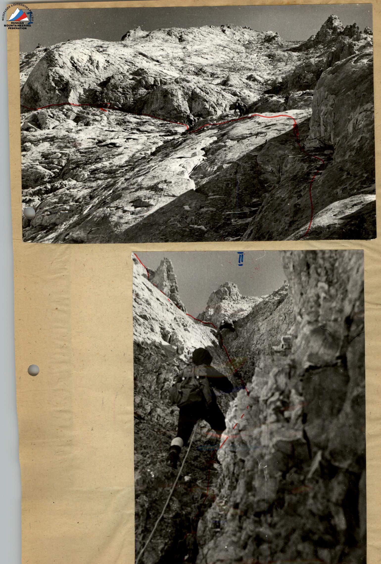
| 7:30–9:00 | R0–R1 | 30° | 500 m | Scree slope | I | Clear sky. Live rocks. | Ice axe self-belay while moving | Simultaneous walking |
| 10:00–10:20 | R1–R2 | 45° | 40 m | "Ram's Forehead" | 2B | Rough rocks. | Alternating via outcrops | Free climbing |
| 10:25–10:40 | R2–R3 | 15° | 65 m | Wide ledge | I | Live rocks | Simultaneously via outcrops | Walking |
| 10:40–12:00 | R3–R4 | 35° | 80 m | Couloir | 2B | - | Four rock pitons, via outcrops alternately | Free climbing |
| 12:00–12:55 | R4–R5 | 25° | 300 m | Rocky ridge | 2A | - | Simultaneously via outcrops | Free climbing |
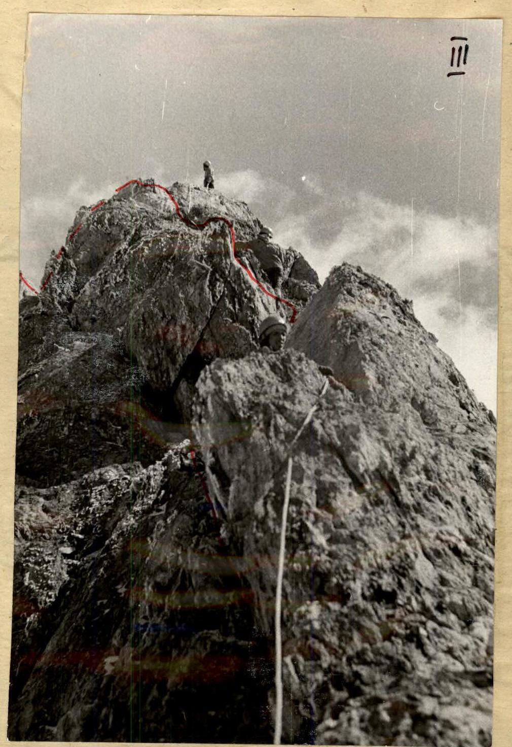
| 13:00–13:40 | R5–R6 | 50° | 40 m | Rocky wall | 3A | Layered slabs | Four rock pitons, via outcrops alternately | Free climbing |
| 13:40–14:00 | R6–R7 | 20° | 160 m | Glacier leading to the summit cairn | I | Solid ice | Simultaneously | Walking |
Retrieved a note left by the first ascensionists, a group from the USSR Armed Forces led by B. Tenigin, from July 1977. Descent via the ascent route and through Joldjilga pass to the base camp 2800 m in Suychichty gorge from 15:00 to 20:30.
Approach: Osh — Iskinaukat — Karakoy forestry — bridge over Kuragan river past the forestry — by any vehicle; from the bridge and up Suychikty gorge to the lower boundary of the juniper forest on the western slopes of Mt. Mazar — only by truck with a cooperative driver. Cross the juniper forest to Joldjilga river and along its right (or.) bank, then along the left bank upwards, bypassing the eastern wall of Gelintash from the left, and then the base of the northern edge of Kyzkochkan. From here, Joldjilga pass is visible, and to the left behind it — the peak Tavriya (4605 m). From the bridge over Kuragan river to Joldjilga pass (bivouac) — 4–5 h with backpacks.
Classification Proposals
The route seems more difficult than 2B, but it is short in terms of technical sections. Nevertheless, it is a very strong and interesting 2B, similar to Amangel'dy, South MNR. The group proposes to include the route they took in the Classification table of routes to mountain peaks of the USSR as:
Tavriya peak 4605, 2B, rocky, via the 3rd ridge.