PASSAGE II ROUTE DOCUMENT
-
Climbing Location — Rock Climbing Category.
-
Climbing Region — Alay Range, Kichik-Alay.
-
Climbing Route — Peak LVO (4003 m) via the Northeast Face.
-
Difficulty Category according to KTGV — 5B category.
-
Route Characteristics:
- Route length — 1000 m,
- Elevation gain — 700 m,
- Length of sections — IV category — 300 m
- V category — 280 m
- VI category — 40 m
- Average steepness — 65°.
- Pitons hammered:
- for belaying (rock) — 61
- for creating artificial holds (rock) — 6.
- Total climbing hours — 8.5 hours
- Number of nights and their characteristics:
- The "two-person team" completed the route without overnight stays. There's a "lying down" overnight stay with water near the 1st cairn, and on the summit ridge; the rest are "sitting" overnight stays.
- Full names of the climbers in the "two-person team":
Dzhibrayev Yuri Georgievich — CMS. Golubev Nikolai Nikolaevich — CMS. 10. Team Coach — Master of Sports of the USSR Gaas Arthur Vasilyevich. 11. Date of departure and return — July 14, 1977.
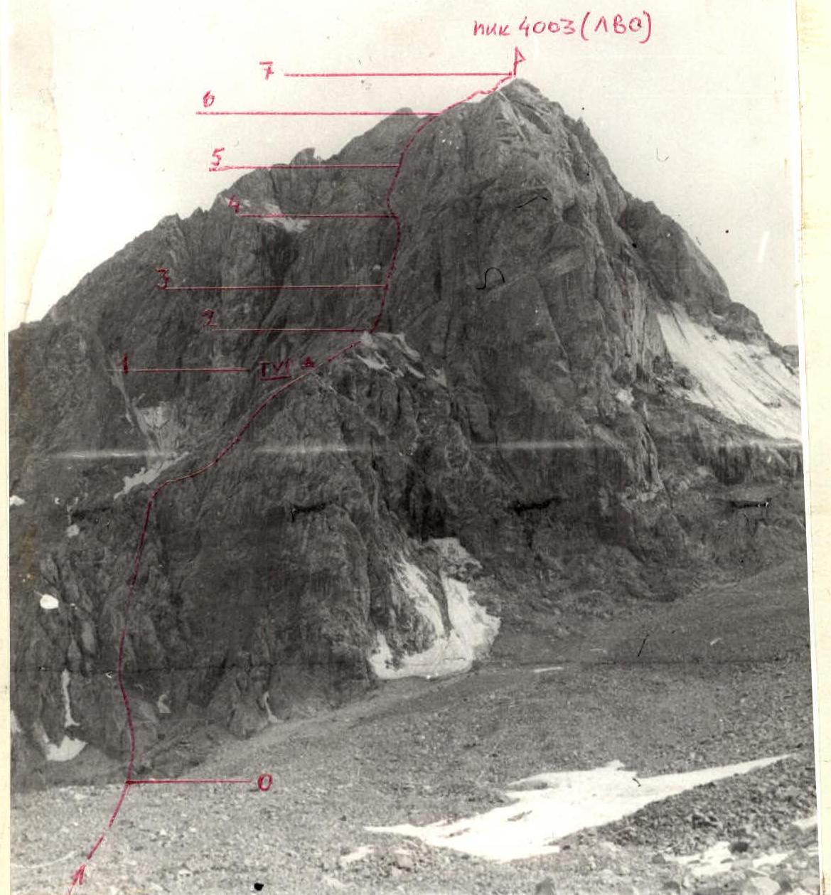
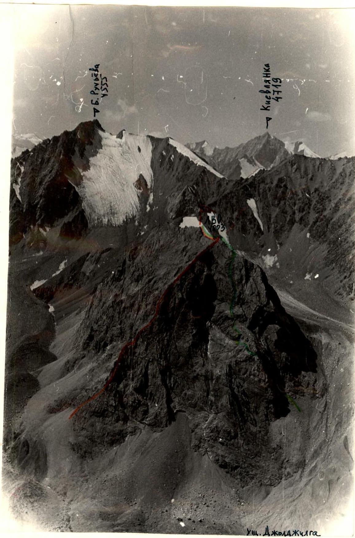
View of Peak LVO from the left bank of the Djoldilta River. Route via the Northeast Face Photo taken from a location 300 m below the foot of the peak.
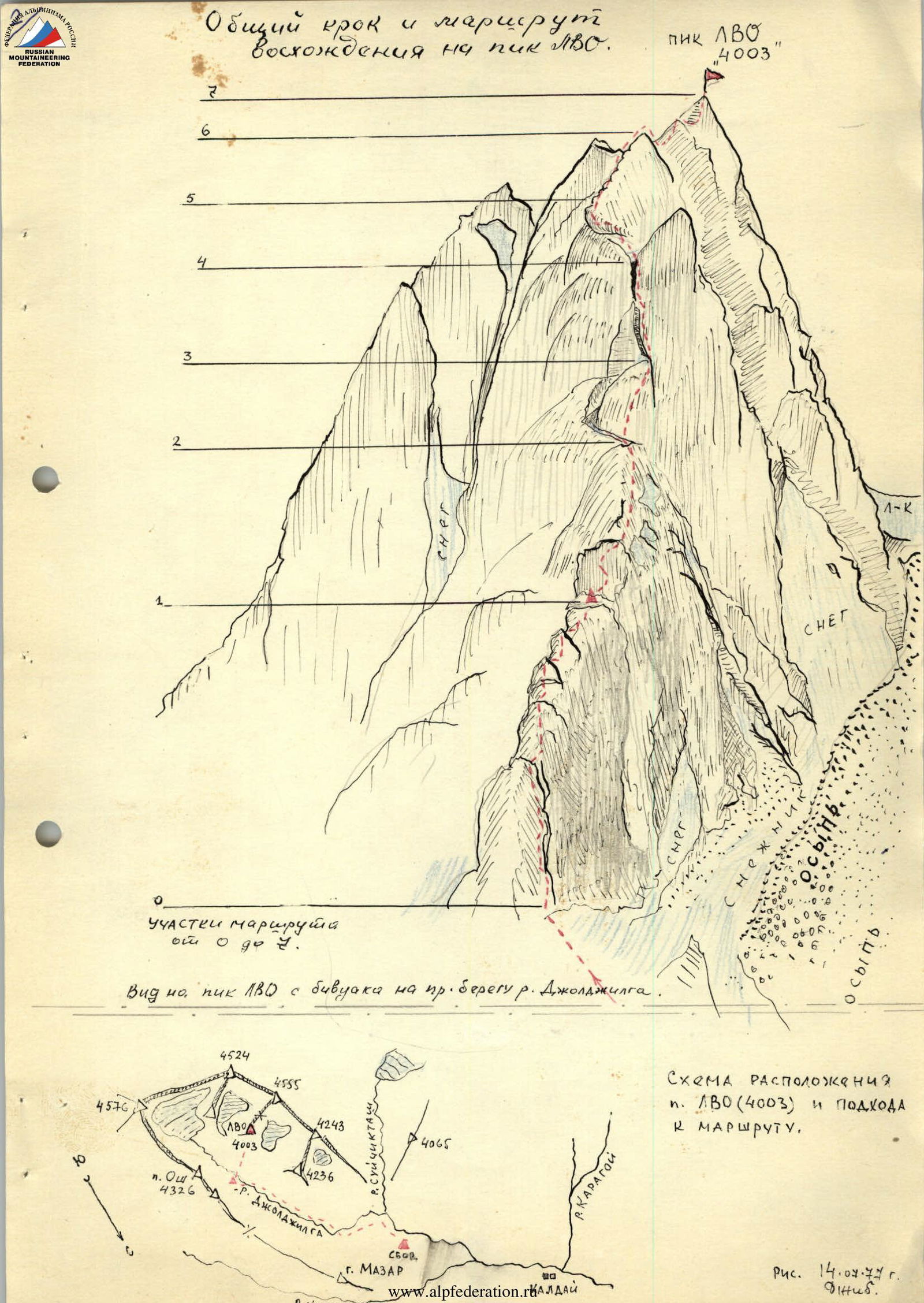
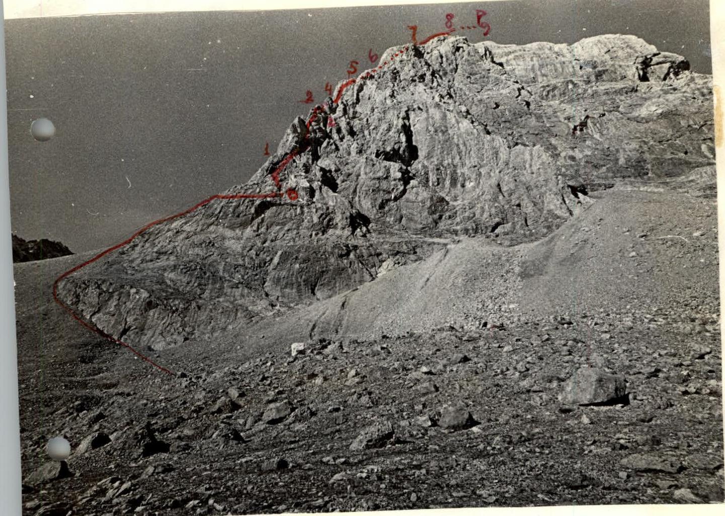
General view and climbing route to Peak LVO. Route sections 0 to 9. View of Peak LVO from the bivouac on the right bank of the Djolajilga River. Layout of Peak LVO (4003) and approach to the route. Drawn on July 14, 1977. Djib.
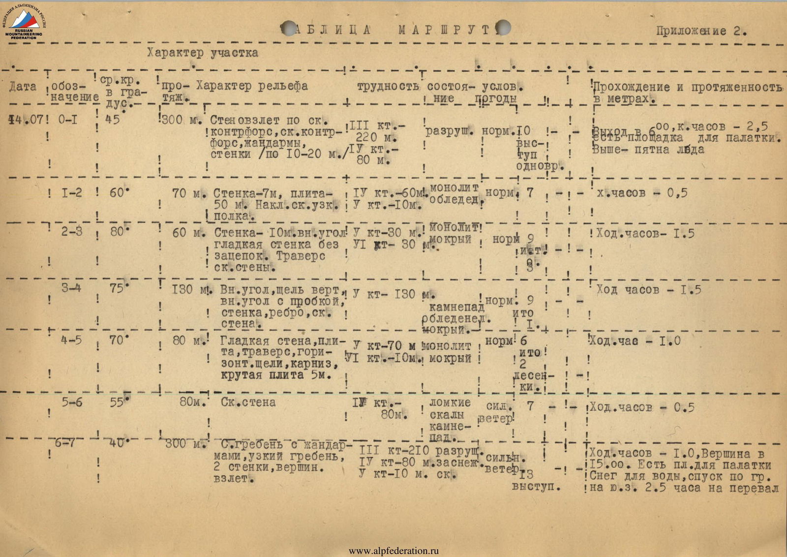
Route Table
Brief explanation for table № 2.
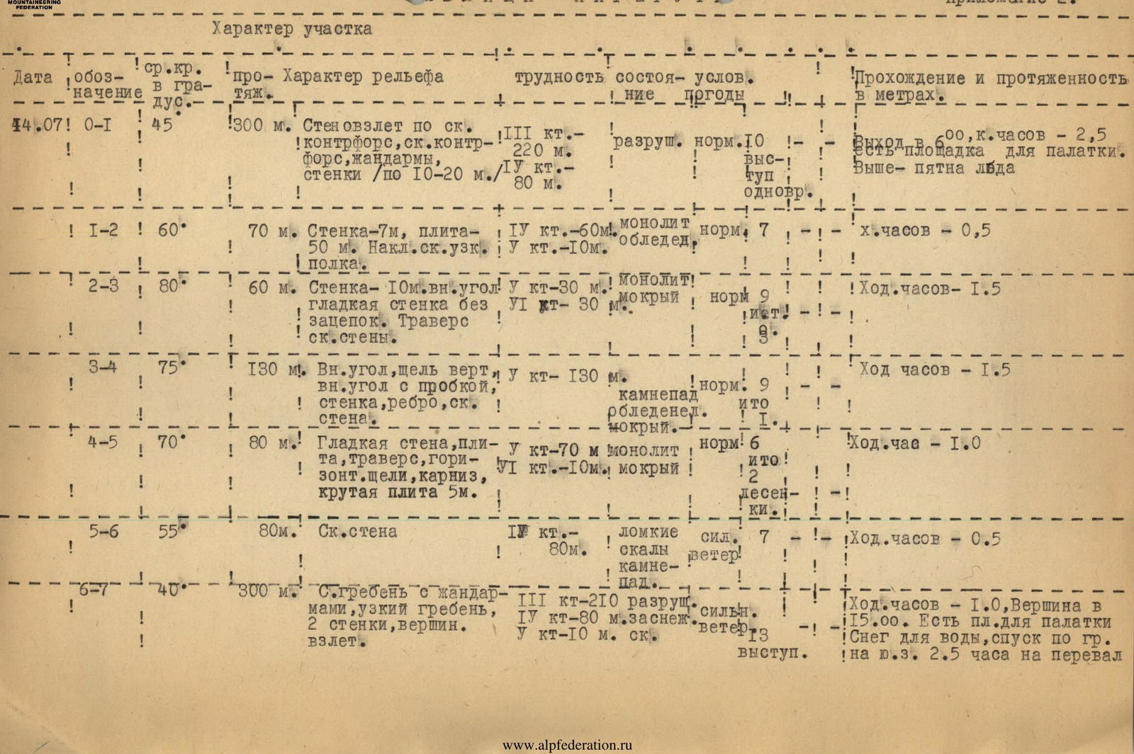
- The route starts on the right side (in the direction of travel) of the counterfort's base, abutting the middle of the wall. The beginning is on a rocky spur, transitioning into a vertical outer corner and a take-off.
- Up to the first cairn, climbing is generally of medium difficulty. The rocks are quite degraded. Walls encountered on the counterfort have holds and are not prolonged. The two-person team took 2.5 hours of climbing time to reach the control cairn, hammering 10 pitons; many places had belays through protrusions and simultaneous movement.
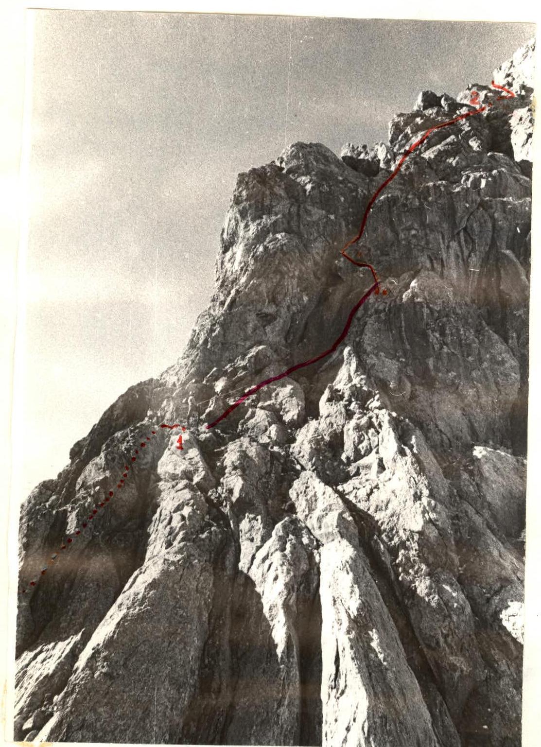
- After the control cairn (section 1–2), a smooth, steep slab with patches of ice and snow remains on the right. It's climbed on friction.
- The route then becomes a pure wall climb with 70° steepness. Section 2–3 — its lower part — is the 1st key point: a 10-meter smooth vertical wall without holds, transitioning into a 5-meter inner wet corner. Here, three pitons are hammered for artificial holds.
- Section 3–4 — 130 m long — a series of sheer gullies and inner corners with boulders and eaves; there are icy sections. Climbers are always one above the other, with a risk of rockfall!!!
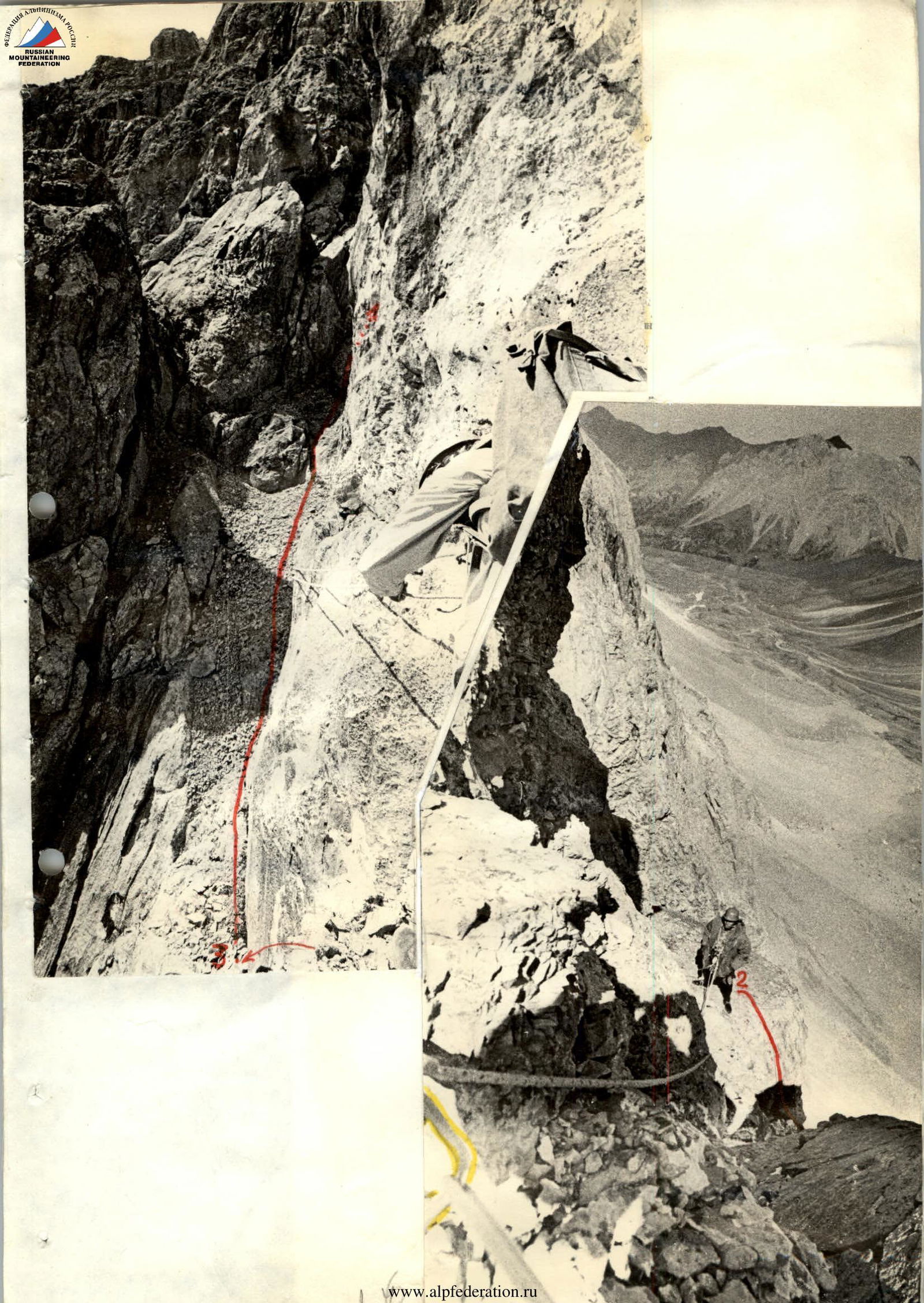
- Section 4–5 — a vertical rocky ridge transitioning into a smooth slab. A traverse to the left starts on a 60° slab, transitioning into a horizontal crack on the slab and approaches a cornice after 15 m (a psychologically challenging spot due to the wall drop below) — ladders are hung here. There are micro-holds. Two pitons are hammered for artificial holds.
- Section 5–6 — an 80 m rock wall with brittle rocks, leading to the northeast ridge.
- Movement along the ridge is blocked by 2 gendarmes; they are climbed directly, with piton belays and living rock anchors (caution). There are convenient spots for overnight stays on the ridge and at the summit.
 The described route.
Route of the Master of Sports of the USSR team–74 (leader A. Gaas) via the Northeast Face, 5B category.
The described route.
Route of the Master of Sports of the USSR team–74 (leader A. Gaas) via the Northeast Face, 5B category.
 x — Ladder here.
XX — See photo on the adjacent page.
x — Ladder here.
XX — See photo on the adjacent page.
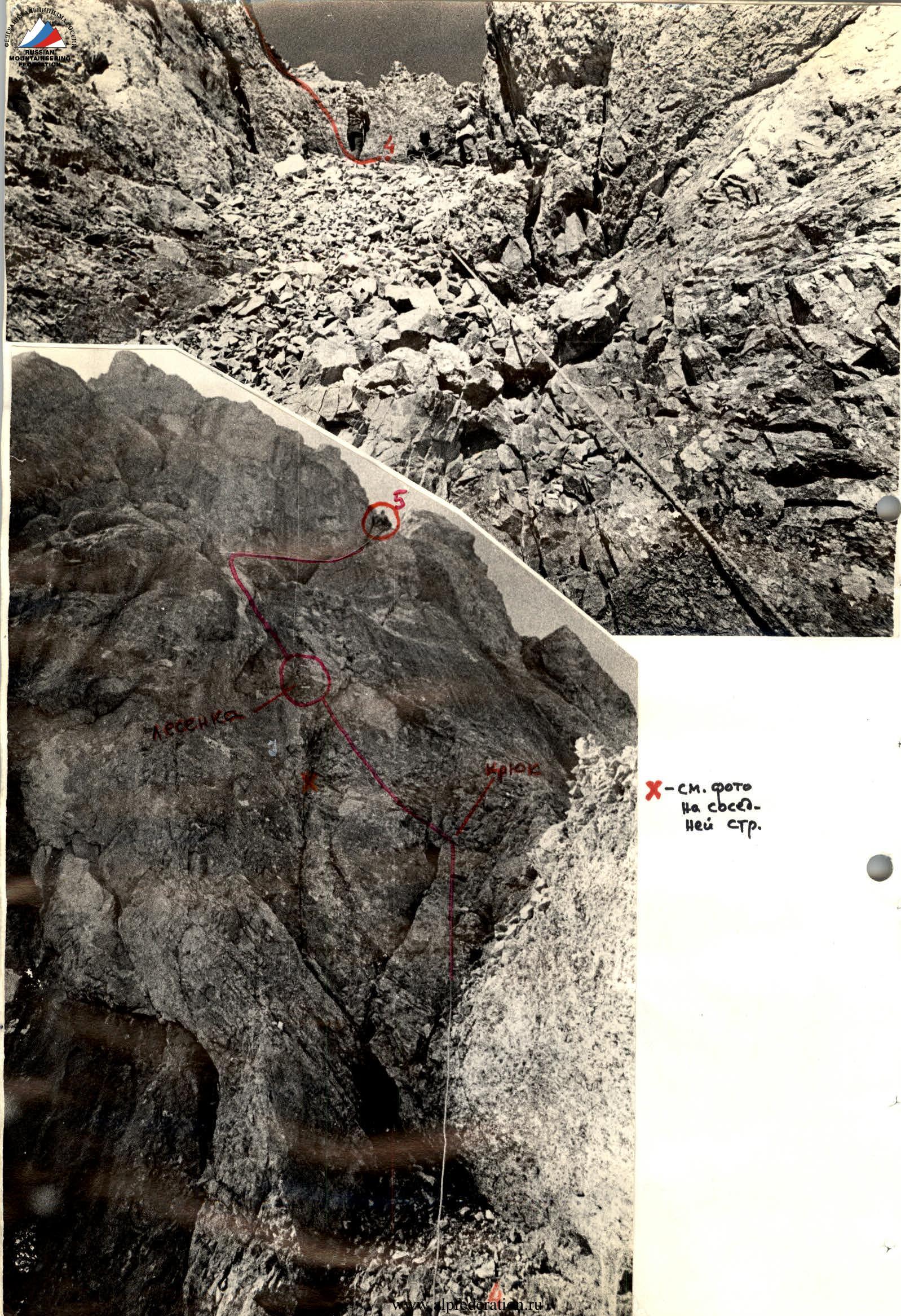 Ladder. Piton.
X — See photo on the adjacent page.
Ladder. Piton.
X — See photo on the adjacent page.
 Section 4–5.

 At the summit of Peak LVO
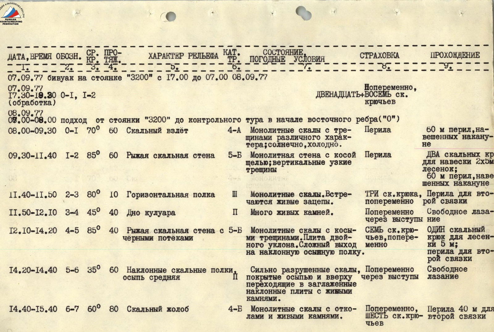

Appendix 2. September 7, 1977, bivouac at the "3200" campsite from 17:00 to 07:00 on September 8, 1977.
| Date, Time | Section | Avg. Steepness | Length | Terrain Characteristics | Category | Conditions, Weather Conditions | Belaying | Climbing |
|---|---|---|---|---|---|---|---|---|
| 07.09.77 | 0–1, 1–2 | (processing) | Alternating, twelve–eight rock pitons | |||||
| 08.09.77 | ||||||||
| 08:00–08:00 | approach | from "3200" campsite to the control cairn at the start of the east ridge ("0") | ||||||
| 08:00–09:30 | 0–1 | 70° | 60 | Rocky ascent | 4 | Monolithic rocks with various cracks; sunny, cold. | Ropes | 60 m of pre-hung ropes |
| 09:30–11:40 | 1–2 | 85° | 60 | Reddish rocky wall | 5 | Monolithic wall with an oblique gap; vertical narrow cracks | Ropes | Two rock pitons for hanging 2×5 m ladders; 60 m of pre-hung ropes |
| 11:40–11:50 | 2–3 | 80° | 10 | Horizontal ledge | 3 | Monolithic rocks. Live holds encountered. | Three rock pitons, alternating | Ropes for the second team |
| 11:50–12:10 | 3–4 | 45° | 40 | Bottom of a gully | 2 | Many loose rocks. | Alternating through protrusions | Free climbing |
| 12:10–14:20 | 4–5 | 85° | 40 | Reddish rocky wall with black streaks | 5 | Monolithic rocks with oblique cracks. Double-slope slab. Complex exit to an inclined scree ledge. | Seven rock pitons, alternating | One rock piton for a 5 m ladder; ropes for the second team |
| 14:20–14:40 | 5–6 | 35° | 60 | Inclined rocky ledges, medium scree | 2 | Heavily degraded rocks, covered with scree and transitioning into smoothed inclined slabs with loose rocks at the top. | Alternating through protrusions | Free climbing |
| 14:40–15:40 | 6–7 | 60° | 80 | Rocky gully | 4 | Monolithic rocks with breaks and loose rocks. | Alternating, six rock pitons | 40 m of ropes for the second team |
| 15:40–16:30 | 7–8 | 40° | 300 | Jagged rocky ridge | 2 | Scree ledges on the ridge covered with loose rocks | Simultaneous, using a thrown rope | Free climbing |
| 16:30–17:00 | 8–9 | 50° | 150 | Rocky ascent leading to the summit of Peak LVO — 3A, slabs with scree ledges, snow. | 3 | Slabs with scree ledges, snow. | Alternating, two rock pitons and protrusions |
17:30–20:00 — descent via the Southwest Ridge, oriented 3B category, then 2×20 m sport climbing to the right, onto the moraines below Kyzkochkan and from there to the "3200" assault camp.
Notes on the table
- The control cairn at the start of the route is at the end of the scree on the left of a narrow gully.
- "3" — a bridge, the reddish overhang beyond it ("4–5") is climbed on the left part, then a transition to the right under the overhanging slab along a narrow crack above vertical drops.
- The cork in the gully ("6–7") is more easily bypassed on the left.
- Places for overnight stays — at "4" and "9".
- On key sections ("1–2") and ("4–5"), it's rational to use double ropes.
Approach
- By car — Osh–Iskinaukat–Karakoy forestry–lower boundary of the juniper forest near the city of Mazar in the Suichikty gorge.
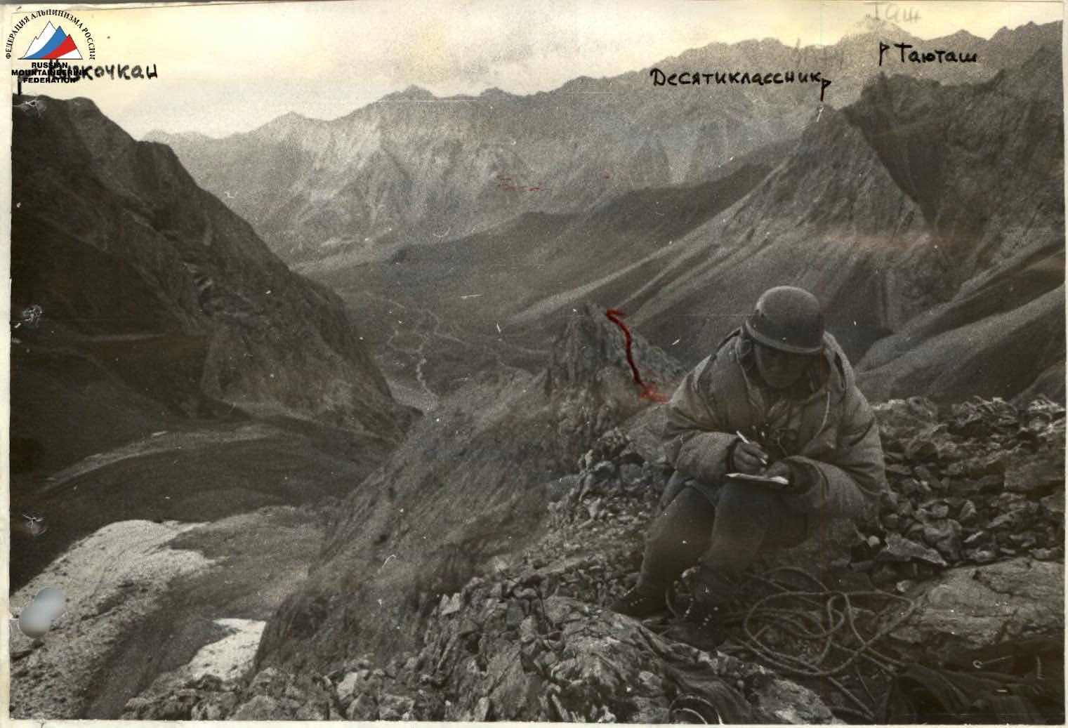
- From here to the "3200" campsite, from where Peak LVO and the profile of its east ridge are visible: through the juniper forest to the Djolajilga River and up along it, bypassing the eastern walls of Gelintas and the base of the north ridge of Kyzkochkan, to the green meadows by the Djolajilga River.
- From the "3200" campsite along the alignment of the moraines on the left (oriented) side of the Djolajilga gorge, without approaching the eastern walls of Kyzkochkan too closely.


