Area of ascent, ridge: PAMIR-ALAI, KICHIK-ALAI ridge Peak: IRBIS peak Height: 4200 m Route: via SE ridge Category: rock climbing FIRST ASCENT Proposed: 1B category difficulty Technical part height difference - 230 m (visual estimate) Total length - 470 m (visual estimate) Sections of V-VI category difficulty - NONE Average steepness of technical sections - 40° Protection - through rock formations Climbing time - 3.5 hours I. LEADER - PERK Yuri Eduardovich, Instructor
Team members: 2. ANDREEV Andrei Alexandrovich, 2nd Class 3. VLADIMIROV Alexei Nikolaevich, unranked 4. VLADIMIROV Andrei Viktorovich, unranked 5. GUSEV Sergei Nikolaevich, unranked 6. KARPENKO Oleg Vasilievich, Instructor 7. NEUGOmonOV Vitaly Petrovich, 2nd Class 8. NIKITIN Dmitri Alekseevich, 2nd Class 9. OVECHKIN Andrei Vasilievich, unranked 10. UILDANOV Vadim Raufovich, unranked II. YAKOVLEVA Natalia Pavlovna, Candidate Master of Sports/Instructor, 1st category
Coach: LEVIN Mikhail Semenovich, Master of Sports of the USSR/Instructor, 1st category - (first passed the key section, set up the rope and returned, handing over the leadership to the head of the "IRBIS" training center)
Date of departure and return: August 16, 1992
ALPINISM FEDERATION
of MAGNITOGORSK
1992
 www.alpfederation.ru↗

NOTE: T1, T2, T3 - photo shooting points

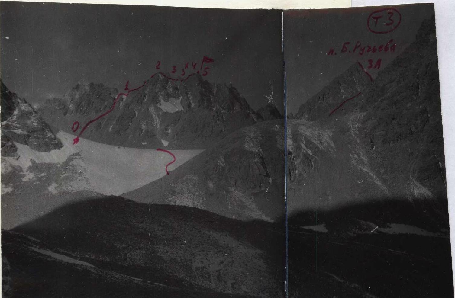
TABLE OF MAIN CHARACTERISTICS of the 1B category difficulty route to IRBIS peak
| DATE and time | Section | Average steepness | Length | Terrain characteristics | Category difficulty | Terrain condition | Weather conditions | Rock anchors |
|---|---|---|---|---|---|---|---|---|
| August 16, 1992 | R0-R1 | 35° | 200 m | Scree with rock outcrops | 1 | Easier to move on rocks - scree is loose, few snow patches | Calm, clear, +12° | - |
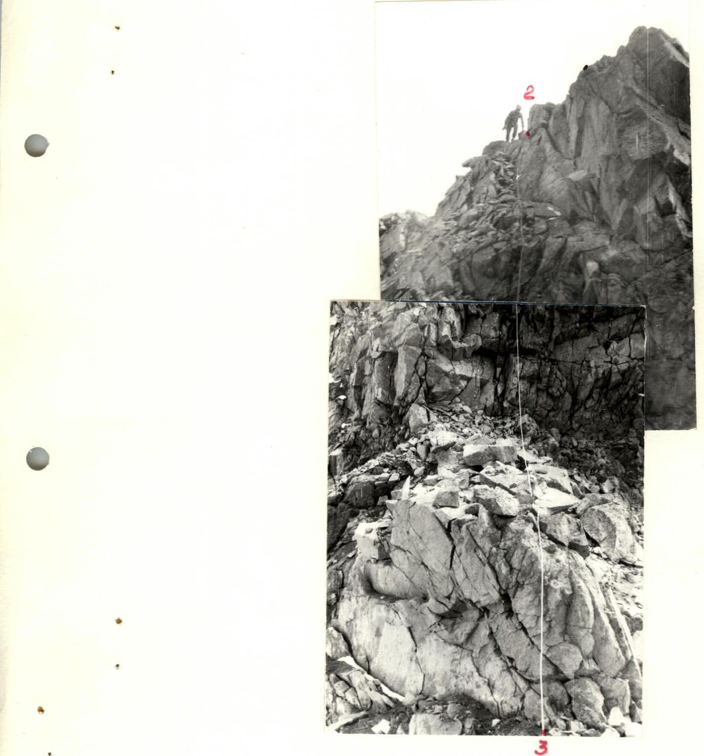
| 8:15-11:45 | R1-R2 | 35° | 150 m | Rocky islands | 1 | Simple for "gendarmes"; ridge narrows | - | - |
| R2-R3 | 60° (20 m) | Inclined ledge (descent) | 3 | Double-slope ledge above a cliff. Do not remove ropes to use them for ascent. | - | 2 | ||
| R3-R3X | - | (80 m) | Scree ridge | 1 | Traverse on scree | - | - | |
| R3X-R4 | 35° | 70 m | Rocky islands | 1 | Not "gendarmes" either; ridge narrows | - | - | |
| R4-R5 | 40° | 50 m | Ridge | 2 | Jagged rocky ridge, many loose rocks on handholds | - | - |
NOTE: No signs of presence on the ridge and summit were found. Only on the "I" saddle a note was found from Ashkhabad tourists who made a radial exit from the upper Suychikty lake on July 12, 1990. "TO BAGIR PASS". The name is not accepted, as the nearby Uraltsev pass, named by Magnitogorsk resident V. I. Mironov in 1977, being 100 m lower than this saddle, is convenient for crossing from N to S, while from S to N the path is more direct through the saddle west of Uraltsev pass. Between the two pass points about 300 m in total, and by analogy with Koy-avgan-aush, it is proposed to call them "Uraltsev pass" and "false Uraltsev pass".
Brief description of the 1B category difficulty route to IRBIS peak: From the confluence of Joldjilga and Suychikty rivers, up the Joldjilga river. In 2-3 hours, ascend to the first terminal moraine of the Joldjilga glacier (not to the second one, 500 m further!) - here is the "3700" base. Having ascended along the junction of the second moraine and the right (or.) slope of the gorge, cross the moraine set to the right-forward and turn behind the southern scree shoulder of Karatash. From here, the summit of Irbis peak is visible against the sky, but the beginning of the path will only open after ascending to the glacier (easier to bypass its tongue R1-R2 35° 150 m to the right). The rocky ridge between Uraltsev pass and the "I" saddle of the route has sections of IV-V category difficulty, so ascending to Uraltsev pass means then descending from it to the west and bypassing the rocky ridge with an exit then to the "I" saddle (false Uraltsev pass - R0-R1 35° 200 m). On the saddle, tie in and simultaneously to "2", here descent-bypass to the right along the ledge and wall (ROPES). Further traverse of the scree ridge. Along rocky islands and narrowing rocky ridge - exit to the summit. Descent via the ascent route.
Descent option:
- Down the couloir from the summit to Suychikty gorge
- Then traverse to the left
- Ascent to Uraltsev pass


