
Ascent Passport. No. 14
- Ascent class: technical
- Ascent region: Pamir-Alay range, Kichik-Alay ridge
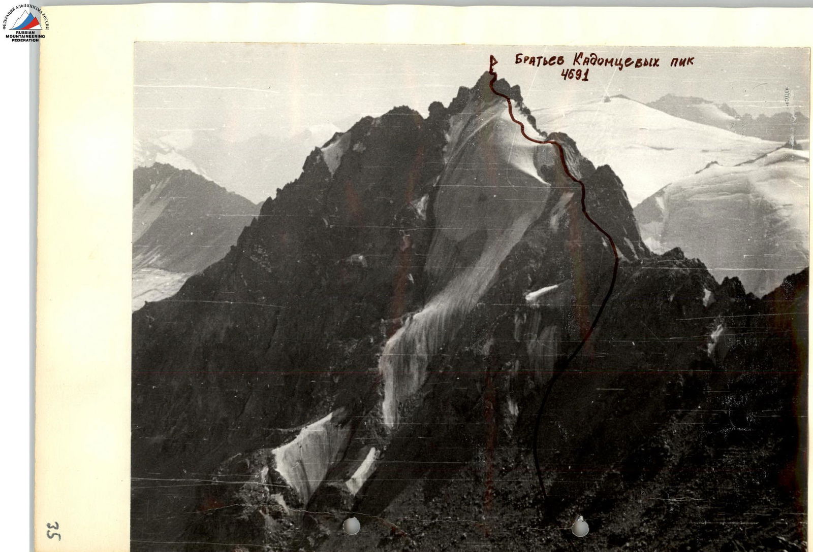
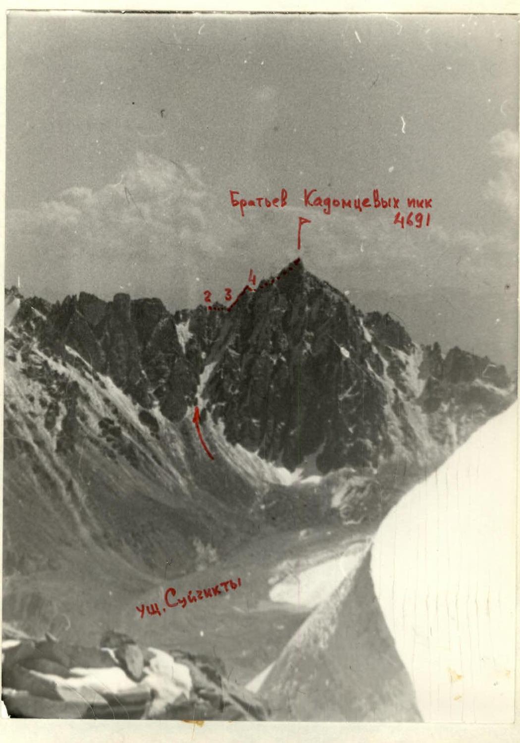
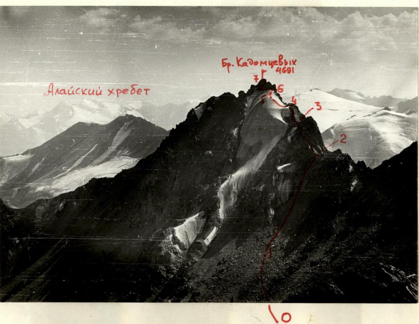
- Summit: Brothers Kadomtsevs Jiiirty Height: 4697 m Ascent route: from the south to the eastern ridge
- Proposed difficulty category: 3A
- Route characteristics:
- Elevation gain: 800 m
- Route length: 5–6 km
- Average slope: 40°
- Pitons used:
- For belay:
- Rock: —
- Ice: 8
- Bolt: —
- For artificial climbing obstacles (I.T.O.):
- Rock: —
- Ice: —
- Bolt: —
- For belay:
- Climbing time: 4.2 hours
- Number of bivouacs and their characteristics: —
- Leader's name, participants, and their qualifications:
- Chernokun S.P. — leader, 2nd sports category
- Sokolov S.A. — 1st sports category
- Eroshina R.I. — 2nd sports category
- Lukyanov A.A. — 2nd sports category
- Samokotin Yu.T. — 2nd sports category
- Team coach: Master of Sports Levin M.S.
- Date of departure and return: September 5, 1977 – September 6, 1977
On September 5, 1977, having ascended to the peak of Legendarnaya Magnitka from the Uraltsi pass, category II, (bivouac from September 4 to 5 on the green meadow "3200" in the Joljilga valley) — 7 working hours, the group descended from the summit to the western ridge and from it immediately to the south for more than 300 m to a small lake, where they set up a bivouac. There is also water under the route, but the bivouac there is threatened by rockfall.
| Date, time | Section | Average slope, length | Terrain characteristics | Difficulty | Conditions, weather | Belay | Ascent |
|---|---|---|---|---|---|---|---|
| September 6, 1977 | |||||||
| 06:30–06:50 | 0–1 | 20°, 500 m | Southern slope of a rocky ridge | 1 | Crossing scree, rocky outcrops. Clear, calm. | — | Walking |
| 07:00–07:50 | 1–2 | 35°, 300 m | Couloir | 1 | Medium and large scree, rocky outcrops | Simultaneous | Walking, free climbing |
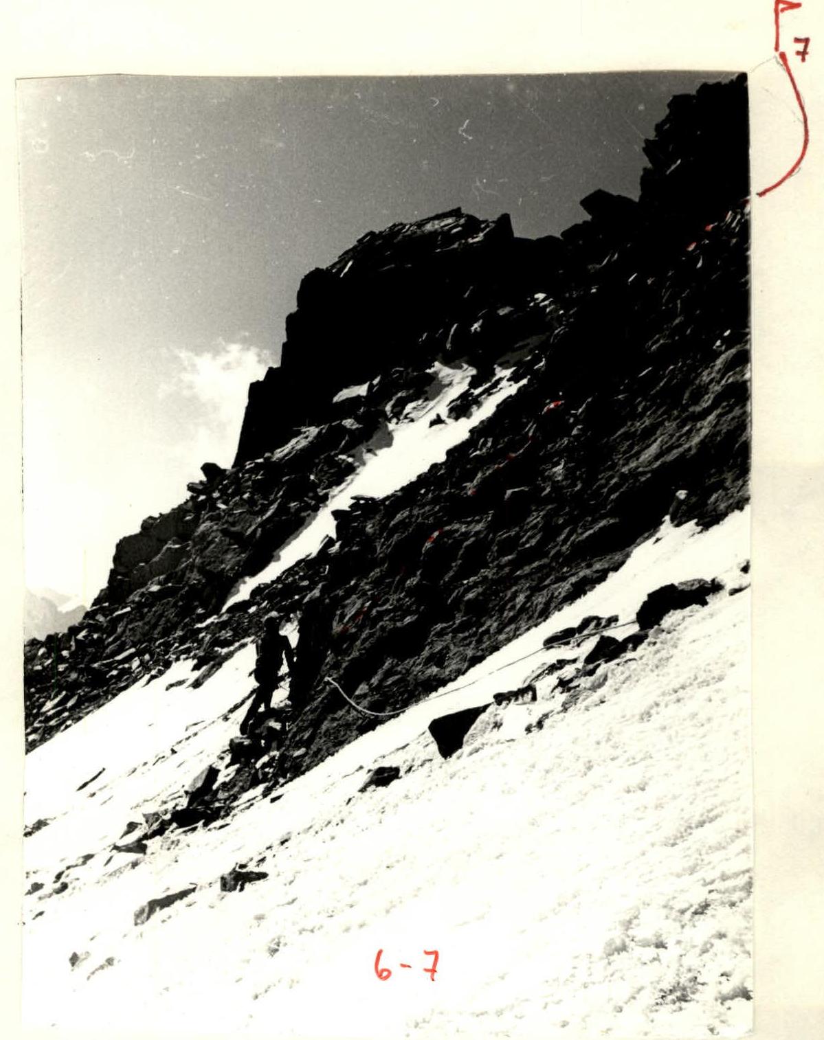
| 08:00–08:30 | 2–3 | 35°, 70 m | Bypass of a gendarme | 2A | Left on slabs, destroyed blocks | Alternating, via ledges | Free climbing |
| 08:30–09:00 | 3–4 | 40°, 50 m | Rocky wall | 2B | Heavily destroyed, wet. Loose rocks. | — | — |
| 09:00–09:50 | 4–5 | 35°, 40 m | Snow-ice slope | 2B | Not more than 10 cm of snow on firm ice | Four ice screws, alternating | Ropes 40 m, steps |
| 09:50–10:30 | 5–6 | 40°, 40 m | — | 3A | — | Four ice screws, alternating | Ropes 40 m, steps |
| 10:30–11:00 | 6–7 | 45°, 50 m | Bypass of the summit tower and ascent to the summit | 3A | Loose slabs, destroyed blocks. To the summit via an internal corner 80°. | Alternating, via ledges | Ropes 40 m |
On the summit, they were surprised to find a can and a poorly preserved note from climbers of the "Alga" sports society from 1959 — out of three surnames, they managed to decipher only "Mukhametvaleev" (current head of the "Ala-Archa" camp). The route is not indicated in the note at all — probably, they ascended from the northwest via a dark couloir.
Descent: Via the ascent route and further through the summit of peak Legendarnaya Magnitka to the Uraltsi pass and down the Suichikty valley to the base camp "2800" — 8 hours.
Approach:
- Osh city — western slopes of Mount Mazar (via Iski-Naukat, Karakol forestry) — by car.
- Cross the juniper grove to the Joljilga river and up along it. Through the Joljilga valley, along the axial part, bypassing the Karatash massif and beyond it to the Uraltsi pass.
- From the Uraltsi pass, follow the route of Yu. Samokotin's group (ChOKVAM-77) to peak Legendarnaya Magnitka — approximately 2A–3B.
- From the summit, descend to the ridge connecting to peak Brothers Kadomtsevs, and from it immediately down to the south to the lake — here is a safe bivouac.
Classification proposals:
Unfortunately, the route turned out to be easier than it looks — there are few sections of category III difficulty. But among other routes of category 2B difficulty climbed by group members, there were no such "fall-prone" ones, lying above steepness and requiring meticulously organized and absolutely reliable belay. Especially unpleasant is the descent via the ascent route, and there are no other options.
Taking into account the above, the group requests to include the route they climbed in the All-Union classification table of mountain routes as:
Brothers Kadomtsevs peak 4691 m 3A combined from the south to the eastern ridge
Biographical note
Brothers Kadomtsev — famous Ural revolutionary Leninists.
Kadomtsev Erasm Samuilovich (born in 1881) — professional revolutionary, member of the RSDLP(b) since 1901. From 1896 to 1900, he worked in Zlatoust, promoting Marxism among workers. In 1905–1907, he organized the first combat squads in the Urals. In Ufa, he met with V.I. Lenin, on whose advice he entered a military school. After graduating from the school, he conducted active work among soldiers. With the arrival of October, he headed all the armed forces of the Southern Urals. In 1918, he worked under the leadership of the remarkable Bolshevik A.D. Tsyurupa.
Kadomtsev Ivan Samuilovich (1884–1918) — professional revolutionary, member of the RSDLP since 1902. Together with his older brother, he led the workers' squads of the Southern Urals. He created an armed detachment at the Zlatoust railway workshops. In October 1917, he took the Kremlin. He died in 1918, defending the gains of the October Revolution in the Urals from the Dutov gangs and wealthy Cossacks.
Kadomtsev Mikhail Samuilovich (1886–1918) — professional revolutionary, member of the RSDLP since 1905. In 1905, he led an armed uprising in Simbirsk, then — chief of staff of the South Ural combat squads. In 1917, he fought against the bands of Ataman Dutov in the Urals, then took command of all armed forces under Samara. There he died for the sacred cause of the Revolution.
The names of the Kadomtsev brothers are given to streets in Chelyabinsk, Ufa, Zlatoust, Miass, and other cities of the Southern Urals.